Long Creek, South Carolina
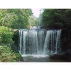
Long Creek: Brasstowne Falls is a series of falls off Hwy 76, in the Long Creek mailing area. About a six minuet slow walk from parking area, will take you to the top of the main falls. The best views are down paths along side the falls.
- add
your
Submit your own pictures of this place and show them to the world
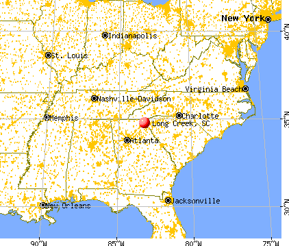
- OSM Map
- General Map
- Google Map
- MSN Map

| Males: 1,189 | |
| Females: 1,126 |
| Median resident age: | 38.0 years |
| South Carolina median age: | 35.4 years |
Zip code: 29693
| Long Creek: | $46,000 |
| SC: | $64,115 |
Estimated per capita income in 2022: $28,451 (it was $14,524 in 2000)
Long Creek CCD income, earnings, and wages data
Estimated median house or condo value in 2022: $191,211 (it was $72,500 in 2000)
| Long Creek: | $191,211 |
| SC: | $254,600 |
Detailed information about poverty and poor residents in Long Creek, SC


- 2,12597.7%White alone
- 180.8%Hispanic
- 120.6%Two or more races
- 70.3%American Indian alone
- 70.3%Asian alone
- 40.2%Other race alone
- 30.1%Black alone

Races in Long Creek detailed stats: ancestries, foreign born residents, place of birth
 Recent articles from our blog. Our writers, many of them Ph.D. graduates or candidates, create easy-to-read articles on a wide variety of topics.
Current Local Time: EST time zone
Land area: 117.5 square miles.
Population density: 20 people per square mile (very low).
| Long Creek CCD: | 0.4% ($260) |
| South Carolina: | 0.6% ($510) |
Nearest city with pop. 50,000+: Greenville, SC  (47.9 miles , pop. 56,002).
Nearest city with pop. 200,000+: Atlanta, GA (96.7 miles , pop. 416,474).
Nearest city with pop. 1,000,000+: Chicago, IL (546.1 miles , pop. 2,896,016).
Nearest cities:
), Latitude: 34.76 N, Longitude: 83.22 W
Area code commonly used in this area: 864


| Here: | 2.9% |
| South Carolina: | 3.1% |

- Construction (15.5%)
- Educational services (7.8%)
- Health care (7.7%)
- Textile mills & textile products (7.1%)
- Accommodation & food services (5.0%)
- Utilities (4.4%)
- Agriculture, forestry, fishing & hunting (4.3%)

- Construction (28.0%)
- Textile mills & textile products (8.2%)
- Utilities (6.4%)
- Agriculture, forestry, fishing & hunting (6.0%)
- Metal & metal products (5.8%)
- Administrative & support & waste management services (4.5%)
- Food & beverage stores (3.7%)

- Health care (13.3%)
- Educational services (12.7%)
- Accommodation & food services (9.3%)
- Textile mills & textile products (5.9%)
- Miscellaneous manufacturing (5.1%)
- Food & beverage stores (4.7%)
- Electrical equipment, appliances, components (4.4%)

- Other production occupations, including supervisors (9.8%)
- Other sales and related occupations, including supervisors (4.9%)
- Electrical equipment mechanics and other installation, maintenance, and repair workers, including supervisors (4.9%)
- Metal workers and plastic workers (4.3%)
- Textile, apparel, and furnishings workers (3.9%)
- Carpenters (3.8%)
- Construction traders workers except carpenters, electricians, painters, plumbers, and construction laborers (3.4%)

- Electrical equipment mechanics and other installation, maintenance, and repair workers, including supervisors (9.3%)
- Other production occupations, including supervisors (8.4%)
- Carpenters (7.2%)
- Other sales and related occupations, including supervisors (6.8%)
- Construction traders workers except carpenters, electricians, painters, plumbers, and construction laborers (6.6%)
- Driver/sales workers and truck drivers (5.4%)
- Metal workers and plastic workers (4.5%)

- Other production occupations, including supervisors (11.4%)
- Other office and administrative support workers, including supervisors (6.6%)
- Cashiers (5.5%)
- Textile, apparel, and furnishings workers (5.3%)
- Health technologists and technicians (5.1%)
- Retail sales workers, except cashiers (5.1%)
- Metal workers and plastic workers (4.0%)
Average climate in Long Creek, South Carolina
Based on data reported by over 4,000 weather stations


(lower is better)

Air Quality Index (AQI) level in 2023 was 52.3. This is better than average.
| City: | 52.3 |
| U.S.: | 72.6 |

Sulfur Dioxide (SO2) [ppb] level in 2019 was 0.0756. This is significantly better than average. Closest monitor was 3.3 miles away from the city center.
| City: | 0.0756 |
| U.S.: | 1.5147 |

Ozone [ppb] level in 2023 was 27.9. This is about average. Closest monitor was 3.3 miles away from the city center.
| City: | 27.9 |
| U.S.: | 33.3 |

Particulate Matter (PM2.5) [µg/m3] level in 2019 was 6.17. This is better than average. Closest monitor was 3.3 miles away from the city center.
| City: | 6.17 |
| U.S.: | 8.11 |
Tornado activity:
Long Creek-area historical tornado activity is near South Carolina state average. It is 10% greater than the overall U.S. average.
On 3/27/1994, a category F3 (max. wind speeds 158-206 mph) tornado 12.0 miles away from the Long Creek place center injured 37 people and caused between $500,000 and $5,000,000 in damages.
On 3/27/1994, a category F3 tornado 14.4 miles away from the place center killed 3 people and injured 45 people and caused between $5,000,000 and $50,000,000 in damages.
Earthquake activity:
Long Creek-area historical earthquake activity is significantly above South Carolina state average. It is 38% greater than the overall U.S. average.On 8/2/1974 at 08:52:09, a magnitude 4.9 (4.3 MB, 4.9 LG, Class: Light, Intensity: IV - V) earthquake occurred 74.3 miles away from Long Creek center
On 11/30/1973 at 07:48:41, a magnitude 4.7 (4.7 MB, 4.6 ML) earthquake occurred 83.2 miles away from the city center
On 8/9/2020 at 12:07:37, a magnitude 5.1 (5.1 MW, Depth: 4.7 mi, Class: Moderate, Intensity: VI - VII) earthquake occurred 168.5 miles away from Long Creek center
On 4/29/2003 at 08:59:39, a magnitude 4.9 (4.4 MB, 4.6 MW, 4.9 LG) earthquake occurred 138.2 miles away from the city center
On 7/27/1980 at 18:52:21, a magnitude 5.2 (5.1 MB, 4.7 MS, 5.0 UK, 5.2 UK) earthquake occurred 241.6 miles away from Long Creek center
On 4/29/2003 at 08:59:39, a magnitude 4.6 (4.6 MW, Depth: 12.3 mi) earthquake occurred 138.3 miles away from the city center
Magnitude types: regional Lg-wave magnitude (LG), body-wave magnitude (MB), local magnitude (ML), surface-wave magnitude (MS), moment magnitude (MW)
Natural disasters:
The number of natural disasters in Oconee County (12) is smaller than the US average (15).Major Disasters (Presidential) Declared: 3
Emergencies Declared: 5
Causes of natural disasters: Hurricanes: 3, Storms: 3, Floods: 2, Ice Storms: 2, Tornadoes: 2, Winds: 2, Drought: 1, Tropical Storm: 1, Winter Storm: 1, Other: 1 (Note: some incidents may be assigned to more than one category).
Hospitals and medical centers near Long Creek:
- MOUNTAIN VIEW HEALTH CARE (Nursing Home, about 13 miles away; CLAYTON, GA)
- FRESENIUS MEDICAL CARE TOCCOA (Dialysis Facility, about 14 miles away; TOCCOA, GA)
- HERITAGE HEALTHCARE OF TOCCOA (Nursing Home, about 14 miles away; TOCCOA, GA)
- OMH HOSPICE OF THE FOOTHILLS (Hospital, about 14 miles away; SENECA, SC)
- MOUNTAIN LAKES MEDICAL CENTER Critical Access Hospitals (about 14 miles away; CLAYTON, GA)
- RABUN COUNTY HOSPITAL (Hospital, about 14 miles away; CLAYTON, GA)
- OMH HOME HEALTH (Home Health Center, about 14 miles away; SENECA, SC)
Operable nuclear power plants near Long Creek:
- 16 miles: Oconee 1 and 2 in Seneca, SC.
- 16 miles: Oconee 3 in Seneca, SC.
Colleges/universities with over 2000 students nearest to Long Creek:
- Piedmont College (about 23 miles; Demorest, GA; Full-time enrollment: 2,251)
- Clemson University (about 23 miles; Clemson, SC; FT enrollment: 20,131)
- Tri-County Technical College (about 26 miles; Pendleton, SC; FT enrollment: 5,174)
- Western Carolina University (about 37 miles; Cullowhee, NC; FT enrollment: 8,684)
- Anderson University (about 38 miles; Anderson, SC; FT enrollment: 2,510)
- Furman University (about 46 miles; Greenville, SC; FT enrollment: 2,988)
- University of North Georgia (about 47 miles; Dahlonega, GA; FT enrollment: 12,445)
Points of interest:
Notable locations in Long Creek: Yellow Branch Campground (A), Cassidy Bridge Campground (B), Woodall Shoals Recreation Site (C), Pine Mountain Hunt Camp (D), Cedar Creek Rifle Range (E), Brysons Apple Orchard (F), Round Mountain Apple Orchard (G), Chattooga Belle Farm (H), Oconee County Rural Fire Department Long Creek (I). Display/hide their locations on the map
Churches in Long Creek include: Long Mountain Church (A), Church of God (B), Mountain Rest Baptist Church (C), Mountain Grove Baptist Church (D), Damascus Baptist Church (E), Brasstown Baptist Church (F), Belmont Baptist Church (G), Zion Church (H), Laurel Spring Church (I). Display/hide their locations on the map
Cemeteries: Rocky Fork Cemetery (1), Rider Mountain Cemetery (2), Mountain Grove Cemetery (3), Laurel Springs Cemetery (4), Damascus Cemetery (5), Brasstown Cemetery (6), Belmont Cemetery (7). Display/hide their locations on the map
Reservoirs: Roletter Pond (A), Tugaloo Lake (B), Yonah Lake (C), Collins Lake (D), Butts Pond (E), Lake Jemike (F), Horseshoe Lake (G), Lake Yonah (H). Display/hide their locations on the map
Streams, rivers, and creeks: Yellow Branch (A), Woodall Branch (B), Swaford Creek (C), Stump Branch (D), Spy Rock Creek (E), Spider Valley Creek (F), Shoulder Bone Branch (G), Sawyer Branch (H), Sawhead Branch (I). Display/hide their locations on the map
Park in Long Creek: Chauga River Scenic Area (1). Display/hide its location on the map
Drinking water stations with addresses in Long Creek that have no violations reported:
- WILD WATER LTD (3770909) (Population served: 68, Primary Water Source Type: Groundwater)
| This place: | 2.5 people |
| South Carolina: | 2.5 people |
| This place: | 68.1% |
| Whole state: | 67.5% |
| This place: | 6.4% |
| Whole state: | 6.0% |
Likely homosexual households (counted as self-reported same-sex unmarried-partner households)
- Lesbian couples: 0.4% of all households
- Gay men: 0.4% of all households
| This place: | 14.1% |
| Whole state: | 14.1% |
| This place: | 5.7% |
| Whole state: | 6.5% |
8 people in workers' group living quarters and job corps centers in 2010
For population 15 years and over in Long Creek:

- Never married: 16.1%
- Now married: 67.6%
- Separated: 1.6%
- Widowed: 7.3%
- Divorced: 9.0%
For population 25 years and over in Long Creek:
- High school or higher: 65.3%
- Bachelor's degree or higher: 9.9%
- Graduate or professional degree: 1.9%
- Unemployed: 1.0%
- Mean travel time to work (commute): 32.9 minutes


| Here: | 14.7 |
| South Carolina average: | 13.2 |
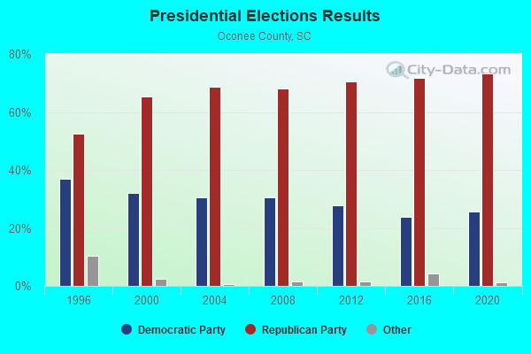
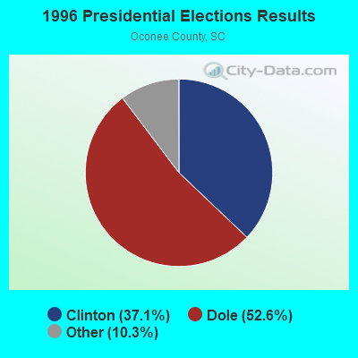


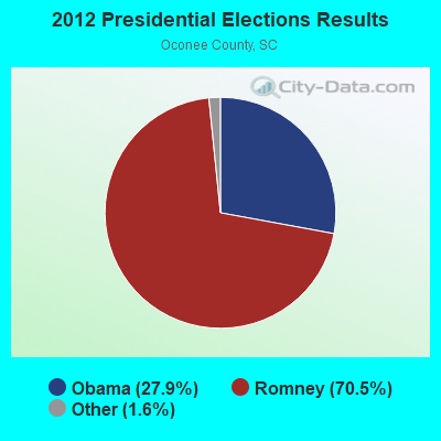
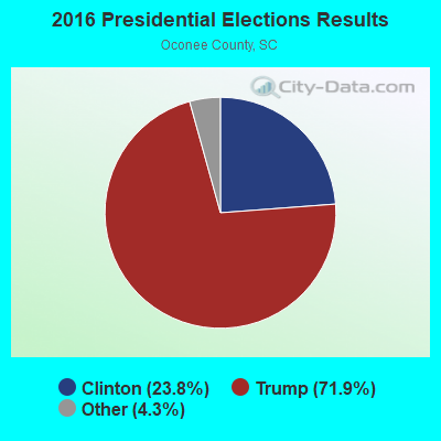
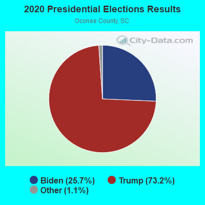
Graphs represent county-level data. Detailed 2008 Election Results
Religion statistics for Long Creek, SC (based on Oconee County data)
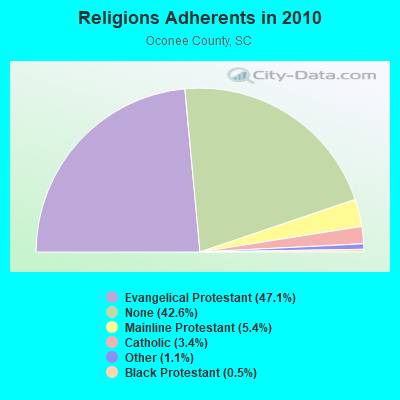
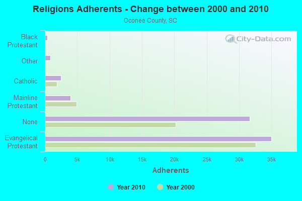
| Religion | Adherents | Congregations |
|---|---|---|
| Evangelical Protestant | 34,998 | 142 |
| Mainline Protestant | 3,996 | 22 |
| Catholic | 2,491 | 2 |
| Other | 818 | 4 |
| Black Protestant | 358 | 4 |
| None | 31,612 | - |
Food Environment Statistics:
| Oconee County: | 1.84 / 10,000 pop. |
| South Carolina: | 1.99 / 10,000 pop. |
| Oconee County: | 0.14 / 10,000 pop. |
| South Carolina: | 0.15 / 10,000 pop. |
| Oconee County: | 1.27 / 10,000 pop. |
| South Carolina: | 0.85 / 10,000 pop. |
| Here: | 4.39 / 10,000 pop. |
| South Carolina: | 5.38 / 10,000 pop. |
| Here: | 6.51 / 10,000 pop. |
| South Carolina: | 7.75 / 10,000 pop. |
| Oconee County: | 11.1% |
| South Carolina: | 10.6% |
| Oconee County: | 28.6% |
| South Carolina: | 29.4% |
| Oconee County: | 16.7% |
| South Carolina: | 13.4% |
Strongest AM radio stations in Long Creek:
- WLFJ (660 AM; daytime; 50 kW; GREENVILLE, SC; Owner: CLEAR CHANNEL BROADCASTING LICENSES, INC.)
- WCSZ (1070 AM; 50 kW; SANS SOUCI, SC; Owner: WHYZ RADIO, L.P.)
- WLET (1420 AM; 5 kW; TOCCOA, GA; Owner: TOCCOA FALLS COLLEGE)
- WGHC (1370 AM; daytime; 2 kW; CLAYTON, GA; Owner: SUTTON RADIOCASTING CORPORATION)
- WCNN (680 AM; 50 kW; NORTH ATLANTA, GA; Owner: DICKEY BROADCASTING COMPANY)
- WDUN (550 AM; 10 kW; GAINESVILLE, GA; Owner: JWJ PROPERTIRS, INC.)
- WSB (750 AM; 50 kW; ATLANTA, GA; Owner: CXR HOLDINGS, INC.)
- WFGW (1010 AM; 50 kW; BLACK MOUNTAIN, NC; Owner: BLUE RIDGE BROADCASTING CORP.)
- WTBI (1540 AM; daytime; 10 kW; PICKENS, SC; Owner: TABERNACLE CHRISTIAN SCHOOLS)
- WGST (640 AM; 50 kW; ATLANTA, GA; Owner: CITICASTERS LICENSES, L.P.)
- WRIX (1020 AM; daytime; 10 kW; HOMELAND PARK, SC; Owner: AM 1020 INCORPORATED)
- WGCR (720 AM; daytime; 10 kW; PISGAH FOREST, NC; Owner: ANCHOR BAPTIST BROADCASTING ASSOCIATION)
- WKVL (850 AM; daytime; 50 kW; KNOXVILLE, TN; Owner: HORNE RADIO, LLC)
Strongest FM radio stations in Long Creek:
- WRBN (104.1 FM; CLAYTON, GA; Owner: SUTTON RADIOCASTING CORPORATION)
- WHZT (98.1 FM; SENECA, SC; Owner: CXR HOLDINGS, INC.)
- W269AY (101.7 FM; HIGHLANDS, NC; Owner: WESTERN NORTH CAROLINA PUBLIC RADIO)
- W277AL (103.3 FM; HIGHLANDS, NC; Owner: CHARISMA RADIO CORPORATION)
- WHLC (104.5 FM; HIGHLANDS, NC; Owner: CHARISMA RADIO CORP.)
- WFQS (91.3 FM; FRANKLIN, NC; Owner: WESTERN NORTH CAROLINA PUBLIC RADIO)
- WRAF (90.9 FM; TOCCOA FALLS, GA; Owner: TOCCOA FALLS COLLEGE)
- W237AR (95.3 FM; HAZELWOOD, ETC., NC; Owner: WESTERN NORTH CAROLINA PUBLIC RADIO)
- WKSF (99.9 FM; ASHEVILLE, NC; Owner: CAPSTAR TX LIMITED PARTNERSHIP)
- WESC-FM (92.5 FM; GREENVILLE, SC; Owner: CLEAR CHANNEL BROADCASTING LICENSES, INC.)
- WCVP-FM (95.9 FM; ROBBINSVILLE, NC; Owner: CHEROKEE BROADCASTING COMPANY, INC.)
- WGOG (96.3 FM; WALHALLA, SC; Owner: APPALACHIAN BROADCASTING CO., INC.)
- WNCC-FM (96.7 FM; FRANKLIN, NC; Owner: SUTTON RADIOCASTING CORPORATION)
- W220CD (91.9 FM; ENKA, NC; Owner: CALVARY CHAPEL OF TWIN FALLS, INC.)
- WNGC (106.1 FM; TOCCOA, GA; Owner: SOUTHERN BROADCASTING OF PENSACOLA, INC)
- WMYI (102.5 FM; HENDERSONVILLE, NC; Owner: CAPSTAR TX LIMITED PARTNERSHIP)
- WBTS (95.5 FM; ATHENS, GA; Owner: CXR HOLDINGS, INC.)
- W218AD (91.5 FM; BREVARD, NC; Owner: WESTERN NORTH CAROLINA PUBLIC RADIO)
- WJMZ-FM (107.3 FM; ANDERSON, SC; Owner: CXR HOLDINGS, INC.)
- WCON-FM (99.3 FM; CORNELIA, GA; Owner: HABERSHAM BROADCASTING CO.)
TV broadcast stations around Long Creek:
- W50AB (Channel 50; HIAWASSEE, GA; Owner: GEORGIA PUBLIC TELECOMMUNICATIONS COMMISSION)
- WNEG-TV (Channel 32; TOCCOA, GA; Owner: MEDIA GENERAL BROADCASTING OF SO. CAROLINA HOLDINGS, INC.)
- WHNS (Channel 21; ASHEVILLE, NC; Owner: MEREDITH CORPORATION)
- W22AC (Channel 22; HARTWELL & ROYSTON, GA; Owner: GEORGIA PUBLIC TELECOMMUNICATIONS COMMISSION)

- 46.8%Electricity
- 30.0%Bottled, tank, or LP gas
- 13.8%Wood
- 8.1%Fuel oil, kerosene, etc.
- 0.7%Utility gas
- 0.7%No fuel used

- 43.1%Electricity
- 27.7%Bottled, tank, or LP gas
- 18.2%Wood
- 10.9%Fuel oil, kerosene, etc.
Long Creek compared to South Carolina state average:
- Unemployed percentage significantly below state average.
- Black race population percentage significantly below state average.
- Hispanic race population percentage significantly below state average.
- Foreign-born population percentage significantly below state average.
- Renting percentage below state average.
- Length of stay since moving in significantly above state average.
- Number of rooms per house significantly below state average.
- House age significantly below state average.
- Percentage of population with a bachelor's degree or higher significantly below state average.