Little Rock, South Carolina
Submit your own pictures of this place and show them to the world
- OSM Map
- General Map
- Google Map
- MSN Map

| Males: 1,702 | |
| Females: 1,829 |
| Median resident age: | 29.9 years |
| South Carolina median age: | 35.4 years |
Zip code: 29567
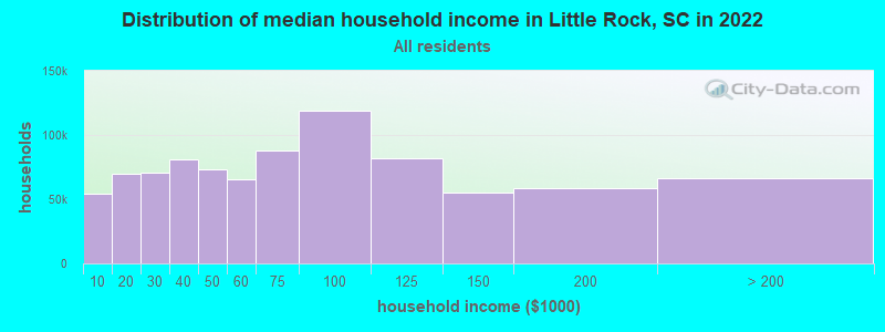
| Little Rock: | $49,469 |
| SC: | $64,115 |
Estimated per capita income in 2022: $18,246 (it was $10,958 in 2000)
Little Rock CCD income, earnings, and wages data
Estimated median house or condo value in 2022: $99,073 (it was $47,000 in 2000)
| Little Rock: | $99,073 |
| SC: | $254,600 |
Mean prices in 2022: all housing units: $165,028; detached houses: $193,514; townhouses or other attached units: $100,842; mobile homes: $81,831
Detailed information about poverty and poor residents in Little Rock, SC


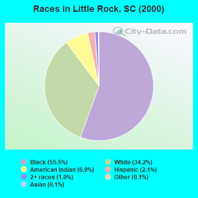
- 1,95855.5%Black alone
- 1,20434.2%White alone
- 2446.9%American Indian alone
- 732.1%Hispanic
- 371.0%Two or more races
- 40.1%Asian alone
- 50.1%Other race alone
Races in Little Rock detailed stats: ancestries, foreign born residents, place of birth
 Recent articles from our blog. Our writers, many of them Ph.D. graduates or candidates, create easy-to-read articles on a wide variety of topics.
Current Local Time: EST time zone
Elevation: 135 feet
Land area: 66.8 square miles.
Population density: 53 people per square mile (very low).

| Little Rock CCD: | 0.6% ($270) |
| South Carolina: | 0.6% ($510) |
Nearest city with pop. 50,000+: Fayetteville, NC  (47.1 miles , pop. 121,015).
Nearest city with pop. 200,000+: Charlotte, NC (93.8 miles , pop. 540,828).
Nearest city with pop. 1,000,000+: Philadelphia, PA (445.7 miles , pop. 1,517,550).
Nearest cities:
), ), ), ), ), Latitude: 34.52 N, Longitude: 79.41 W

| Here: | 4.2% |
| South Carolina: | 3.1% |

- Textile mills & textile products (15.2%)
- Accommodation & food services (11.1%)
- Construction (7.5%)
- Food (7.3%)
- Educational services (7.0%)
- Agriculture, forestry, fishing & hunting (5.7%)
- Machinery (4.2%)

- Textile mills & textile products (18.3%)
- Construction (12.9%)
- Agriculture, forestry, fishing & hunting (10.2%)
- Accommodation & food services (7.2%)
- Food (4.6%)
- Transportation equipment (4.2%)
- Truck transportation (3.8%)

- Accommodation & food services (15.6%)
- Educational services (12.8%)
- Textile mills & textile products (11.5%)
- Food (10.3%)
- Health care (5.6%)
- Public administration (5.5%)
- Machinery (4.8%)

- Other production occupations, including supervisors (9.5%)
- Building and grounds cleaning and maintenance occupations (6.5%)
- Textile, apparel, and furnishings workers (6.2%)
- Metal workers and plastic workers (5.2%)
- Agricultural workers, including supervisors (3.8%)
- Other management occupations, except farmers and farm managers (3.6%)
- Cashiers (3.6%)

- Building and grounds cleaning and maintenance occupations (8.3%)
- Metal workers and plastic workers (7.7%)
- Other production occupations, including supervisors (7.5%)
- Driver/sales workers and truck drivers (6.4%)
- Other material moving workers, except laborers (6.2%)
- Electrical equipment mechanics and other installation, maintenance, and repair workers, including supervisors (6.1%)
- Laborers and material movers, hand (5.4%)

- Other production occupations, including supervisors (11.8%)
- Textile, apparel, and furnishings workers (8.9%)
- Cashiers (7.6%)
- Other office and administrative support workers, including supervisors (5.5%)
- Building and grounds cleaning and maintenance occupations (4.5%)
- Preschool, kindergarten, elementary, and middle school teachers (3.7%)
- Secretaries and administrative assistants (3.7%)
Average climate in Little Rock, South Carolina
Based on data reported by over 4,000 weather stations


(lower is better)

Lead (Pb) [µg/m3] level in 2001 was 0.00334. This is significantly better than average. Closest monitor was 6.9 miles away from the city center.
| City: | 0.00334 |
| U.S.: | 0.00931 |
Tornado activity:
Little Rock-area historical tornado activity is near South Carolina state average. It is 13% greater than the overall U.S. average.
On 3/28/1984, a category F4 (max. wind speeds 207-260 mph) tornado 11.3 miles away from the Little Rock place center killed 7 people and injured 100 people and caused between $5,000,000 and $50,000,000 in damages.
On 3/28/1984, a category F4 tornado 13.5 miles away from the place center killed 4 people and injured 395 people and caused between $5,000,000 and $50,000,000 in damages.
Earthquake activity:
Little Rock-area historical earthquake activity is significantly above South Carolina state average. It is 47% smaller than the overall U.S. average.On 8/23/2011 at 17:51:04, a magnitude 5.8 (5.8 MW, Depth: 3.7 mi, Class: Moderate, Intensity: VI - VII) earthquake occurred 248.6 miles away from Little Rock center
On 8/9/2020 at 12:07:37, a magnitude 5.1 (5.1 MW, Depth: 4.7 mi) earthquake occurred 165.4 miles away from Little Rock center
On 11/22/1974 at 05:25:55, a magnitude 4.7 (4.7 MB, Class: Light, Intensity: IV - V) earthquake occurred 119.7 miles away from the city center
On 8/2/1974 at 08:52:09, a magnitude 4.9 (4.3 MB, 4.9 LG) earthquake occurred 181.8 miles away from Little Rock center
On 8/21/1992 at 16:31:55, a magnitude 4.4 (4.1 MB, 4.1 LG, 4.4 LG, Depth: 6.2 mi) earthquake occurred 109.4 miles away from Little Rock center
On 9/25/2006 at 05:44:20, a magnitude 3.7 (3.7 ML, Depth: 3.1 mi, Class: Light, Intensity: II - III) earthquake occurred 2.4 miles away from Little Rock center
Magnitude types: regional Lg-wave magnitude (LG), body-wave magnitude (MB), local magnitude (ML), moment magnitude (MW)
Natural disasters:
The number of natural disasters in Dillon County (18) is near the US average (15).Major Disasters (Presidential) Declared: 9
Emergencies Declared: 5
Causes of natural disasters: Hurricanes: 10, Winter Storms: 3, Floods: 2, Storms: 2, Ice Storm: 1, Tropical Storm: 1, Other: 1 (Note: some incidents may be assigned to more than one category).
Hospitals and medical centers near Little Rock:
- HERITAGE HEALTHCARE CENTER AT THE PINES (Nursing Home, about 7 miles away; DILLON, SC)
- HAVEN HOSPICE OF ST EUGENE COM HOSP (Hospital, about 8 miles away; DILLON, SC)
- MCLEOD MEDICAL CENTER - DILLON Acute Care Hospitals (about 8 miles away; DILLON, SC)
- ST EUGENE COMM HOSP SK MED REHAB UNIT (Nursing Home, about 8 miles away; DILLON, SC)
- COMMUNITY HOME CARE AND HOSPICE (Hospital, about 8 miles away; DILLON, SC)
- DILLON COMM. RES. (Hospital, about 8 miles away; DILLON, SC)
- FRESENIUS MEDICAL CARE DILLON (Dialysis Facility, about 8 miles away; DILLON, SC)
Colleges/universities with over 2000 students nearest to Little Rock:
- University of North Carolina at Pembroke (about 17 miles; Pembroke, NC; Full-time enrollment: 5,548)
- Robeson Community College (about 25 miles; Lumberton, NC; FT enrollment: 2,322)
- Francis Marion University (about 27 miles; Florence, SC; FT enrollment: 3,624)
- Florence-Darlington Technical College (about 31 miles; Florence, SC; FT enrollment: 4,468)
- Richmond Community College (about 32 miles; Hamlet, NC; FT enrollment: 2,106)
- Fayetteville Technical Community College (about 47 miles; Fayetteville, NC; FT enrollment: 10,114)
- Fayetteville State University (about 49 miles; Fayetteville, NC; FT enrollment: 5,297)
Points of interest:
Notable locations in Little Rock: Glasdrum Farms (A), Oakland Volunteer Fire Department (B). Display/hide their locations on the map
Churches in Little Rock include: State Line Church (A), Pee Dee Chapel (B), New Holy Church (C), Mount Zion Church (D), Fairview Church (E), Carolina Church (F), Beulah Church (G), Millers Chapel (H), Minturn Church (I). Display/hide their locations on the map
Cemeteries: Baker Cemetery (1), Price Cemetery (2), Sherwood Cemetery (3), Little Rock Cemetery (4), Oakland United Methodist Church Cemetery (5), Leland Grove Cemetery (6), Fairview Church Cemetery (7). Display/hide their locations on the map
Swamps: Donohoe Bay (A). Display/hide its location on the map
Streams, rivers, and creeks: Shoe Heel Creek (A), Wash Branch (B), Hayes Swamp (C), Sweat Swamp (D), Carolina Branch (E), Beaverdam Creek (F), Martins Branch (G). Display/hide their locations on the map
| This place: | 3.0 people |
| South Carolina: | 2.5 people |
| This place: | 75.0% |
| Whole state: | 67.5% |
| This place: | 7.7% |
| Whole state: | 6.0% |
Likely homosexual households (counted as self-reported same-sex unmarried-partner households)
- Lesbian couples: 0.3% of all households
- Gay men: 0.4% of all households
| This place: | 25.5% |
| Whole state: | 14.1% |
| This place: | 12.8% |
| Whole state: | 6.5% |
For population 15 years and over in Little Rock:

- Never married: 34.9%
- Now married: 51.4%
- Separated: 4.7%
- Widowed: 7.6%
- Divorced: 6.1%
For population 25 years and over in Little Rock:
- High school or higher: 58.2%
- Bachelor's degree or higher: 7.0%
- Graduate or professional degree: 1.3%
- Unemployed: 9.3%
- Mean travel time to work (commute): 42.7 minutes


| Here: | 14.0 |
| South Carolina average: | 13.2 |
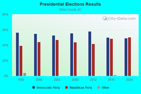
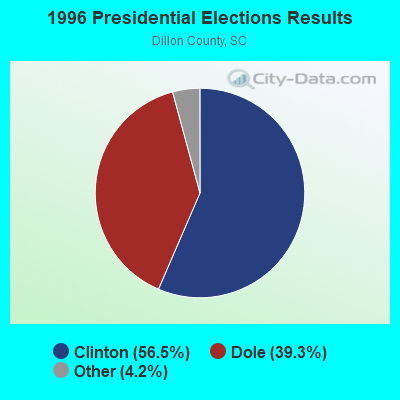
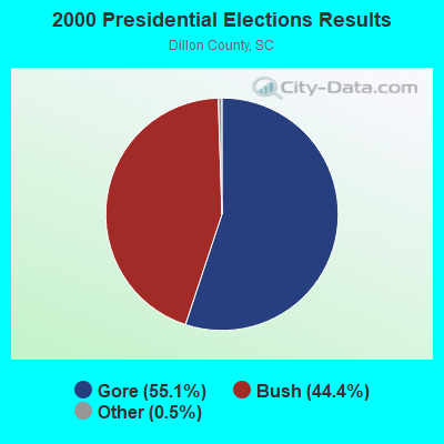
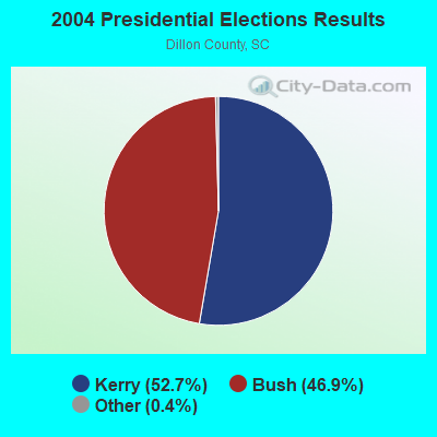
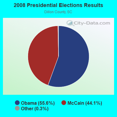
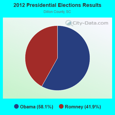
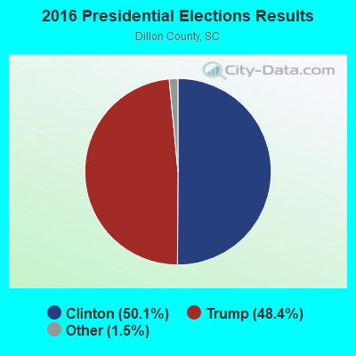
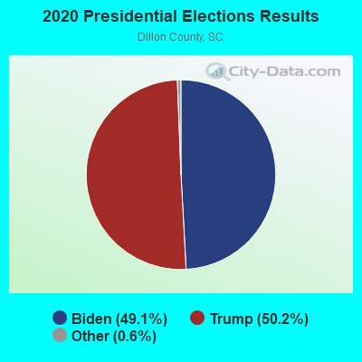
Graphs represent county-level data. Detailed 2008 Election Results
Religion statistics for Little Rock, SC (based on Dillon County data)
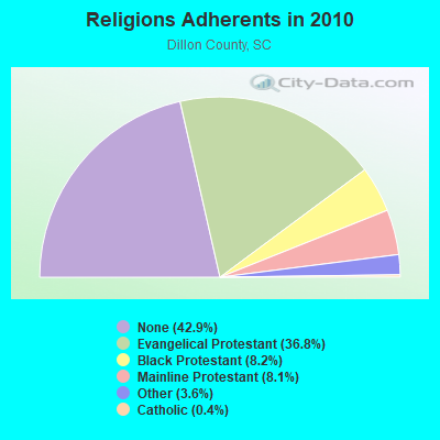
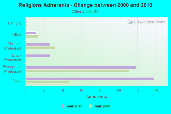
| Religion | Adherents | Congregations |
|---|---|---|
| Evangelical Protestant | 11,799 | 48 |
| Black Protestant | 2,645 | 15 |
| Mainline Protestant | 2,592 | 24 |
| Other | 1,155 | - |
| Catholic | 128 | 1 |
| None | 13,743 | - |
Food Environment Statistics:
| This county: | 2.93 / 10,000 pop. |
| South Carolina: | 1.99 / 10,000 pop. |
| Here: | 1.96 / 10,000 pop. |
| South Carolina: | 0.85 / 10,000 pop. |
| Dillon County: | 7.83 / 10,000 pop. |
| South Carolina: | 5.38 / 10,000 pop. |
| Dillon County: | 6.85 / 10,000 pop. |
| South Carolina: | 7.75 / 10,000 pop. |
| Dillon County: | 13.1% |
| South Carolina: | 10.6% |
| This county: | 33.6% |
| State: | 29.4% |
| Dillon County: | 14.3% |
| South Carolina: | 13.4% |
Strongest AM radio stations in Little Rock:
- WBSC (1550 AM; 10 kW; BENNETTSVILLE, SC; Owner: D-MITCH BROADCASTING, INC.)
- WJMX (970 AM; 10 kW; FLORENCE, SC; Owner: QANTUM OF FLORENCE LICENSE COMPANY, LLC)
- WDSC (800 AM; 1 kW; DILLON, SC; Owner: QANTUM OF FLORENCE LICENSE COMPANY, LLC)
- WEWO (1460 AM; 5 kW; LAURINBURG, NC; Owner: SERVICE MEDIA, INC.)
- WCEO (840 AM; daytime; 50 kW; COLUMBIA, SC; Owner: EASTERN BROADCASTING GROUP, INC.)
- WPTF (680 AM; 50 kW; RALEIGH, NC; Owner: FIRST STATE COMMUNICATIONS)
- WFNC (640 AM; 10 kW; FAYETTEVILLE, NC; Owner: CUMULUS LICENSING CORP.)
- WYRU (1160 AM; 5 kW; RED SPRINGS, NC; Owner: WDAS LICENSE LIMITED PARTNERSHIP)
- WJAY (1280 AM; 4 kW; MULLINS, SC; Owner: THE GREATER HWY CHURCH OF CHRIST)
- WBAJ (890 AM; daytime; 50 kW; BLYTHEWOOD, SC; Owner: FAMILY FIRST)
- WBT (1110 AM; 50 kW; CHARLOTTE, NC; Owner: JEFFERSON-PILOT COMMUNICATNS CO. OF NORTH CAROLINA)
- WLWL (770 AM; daytime; 5 kW; ROCKINGHAM, NC; Owner: SANDHILLS BROADCASTING CO., INC.)
- WKKE (1080 AM; daytime; 5 kW; ST. PAULS, NC; Owner: FERRIS YARNELL LOCKLEAR)
Strongest FM radio stations in Little Rock:
- WEGX (92.9 FM; DILLON, SC; Owner: QANTUM OF FLORENCE LICENSE COMPANY, LLC)
- WCMG (94.3 FM; LATTA, SC; Owner: CUMULUS LICENSING CORP.)
- WFLB (96.5 FM; LAURINBURG, NC; Owner: WFLB LICENSE LIMITED PARTNERSHIP)
- WHLZ (100.5 FM; MARION, SC; Owner: CUMULUS LICENSING CORP.)
- WKML (95.7 FM; LUMBERTON, NC; Owner: WKML LICENSE LIMITED PARTNERSHIP)
- WUKS (107.7 FM; ST. PAULS, NC; Owner: WDAS LICENSE LIMITED PARTNERSHIP)
- WZFX (99.1 FM; WHITEVILLE, NC; Owner: WDAS LICENSE LIMITED PARTNERSHIP)
- WQSD (107.1 FM; BRIARCLIFF ACRES, SC; Owner: QANTUM OF MYRTLE BEACH LICENSE COMPANY, LLC)
- WJMX-FM (103.3 FM; CHERAW, SC; Owner: QANTUM OF FLORENCE LICENSE COMPANY, LLC)
- WJSG (104.3 FM; HAMLET, NC; Owner: JACKSON BROADCASTING COMPANY)
- WYNN-FM (106.3 FM; FLORENCE, SC; Owner: CUMULUS LICENSING CORP.)
TV broadcast stations around Little Rock:
- WPDE-TV (Channel 15; FLORENCE, SC; Owner: GRAND STRAND COMMUNICATIONS)
- WWMB (Channel 21; FLORENCE, SC; Owner: ATLANTIC MEDIA GROUP, INC.)
- WBTW (Channel 13; FLORENCE, SC; Owner: MEDIA GENERAL BROADCASTING OF SO. CAROLINA HOLDINGS, INC.)
- WSFX-TV (Channel 26; WILMINGTON, NC; Owner: SOUTHEASTERN MEDIA HOLDINGS, INC.)
- WUNU (Channel 31; LUMBERTON, NC; Owner: UNIVERSITY OF NORTH CAROLINA)
- W66DE (Channel 50; FLORENCE, SC; Owner: CAROLINA CHRISTIAN BROADCASTING, INC.)
- WLPS-LP (Channel 7; LUMBERTON/PEMBROKE, NC; Owner: BILLY RAY LOCKLEAR)
- WJPM-TV (Channel 33; FLORENCE, SC; Owner: SOUTH CAROLINA EDUCATIONAL TV COMMISSION)
- WECT (Channel 6; WILMINGTON, NC; Owner: RAYCOM AMERICA, INC.)
- WFPX (Channel 62; FAYETTEVILLE, NC; Owner: PAXSON COMMUNICATIONS LICENSE COMPANY, LLC)
- W67DU (Channel 67; LUMBERTON, NC; Owner: TRINITY BROADCASTING NETWORK)
- WPEM-LP (Channel 47; LUMBERTON, NC; Owner: GERALD LOCKLEAR)
- W19CA (Channel 19; LUMBERTON, NC; Owner: PACIFIC MEDIA CORPORATION)
FCC Registered Antenna Towers:
13 (See the full list of FCC Registered Antenna Towers in Little Rock)FCC Registered Broadcast Land Mobile Towers:
1- Minturn Rd (Lat: 34.517167 Lon: -79.474333), Type: Building, Structure height: 3 m, Overall height: 4.3 m, Call Sign: WRAQ289,
Assigned Frequencies: 160.785 MHz, Grant Date: 01/26/2018, Expiration Date: 01/26/2028, Certifier: Shantrice Cruse-Scott, Registrant: Csx Transportation Inc, 6735 Southpoint Dr S, 4th Flr J958, Jacksonville, FL 32216, Phone: (904) 332-5925, Fax: (904) 332-6013, Email:
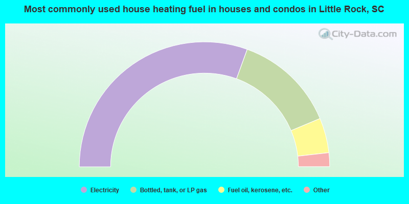
- 61.1%Electricity
- 26.3%Bottled, tank, or LP gas
- 9.0%Fuel oil, kerosene, etc.
- 1.1%Utility gas
- 1.0%No fuel used
- 0.9%Other fuel
- 0.7%Wood
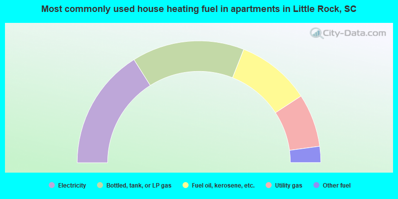
- 32.1%Electricity
- 29.9%Bottled, tank, or LP gas
- 19.6%Fuel oil, kerosene, etc.
- 14.1%Utility gas
- 4.3%Other fuel
Little Rock compared to South Carolina state average:
- Median house value significantly below state average.
- Black race population percentage above state average.
- Hispanic race population percentage significantly below state average.
- Median age below state average.
- Foreign-born population percentage significantly below state average.
- Length of stay since moving in significantly above state average.
- Number of rooms per house significantly below state average.
- House age significantly below state average.
- Percentage of population with a bachelor's degree or higher significantly below state average.
Little Rock on our top lists:
- #31 on the list of "Top 101 cities with the largest percentage of people in homes for the mentally ill (population 1,000+)"