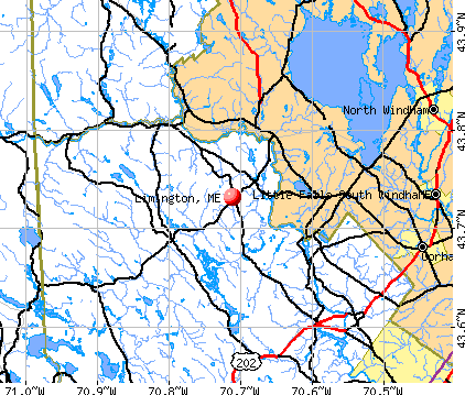
Limington, Maine
Submit your own pictures of this town and show them to the world
- OSM Map
- General Map
- Google Map
- MSN Map
Population change since 2000: +9.1%
 |
| Males: 1,855 | |
| Females: 1,858 |
| Median resident age: | 38.9 years |
| Maine median age: | 43.0 years |
Zip codes: 04049.
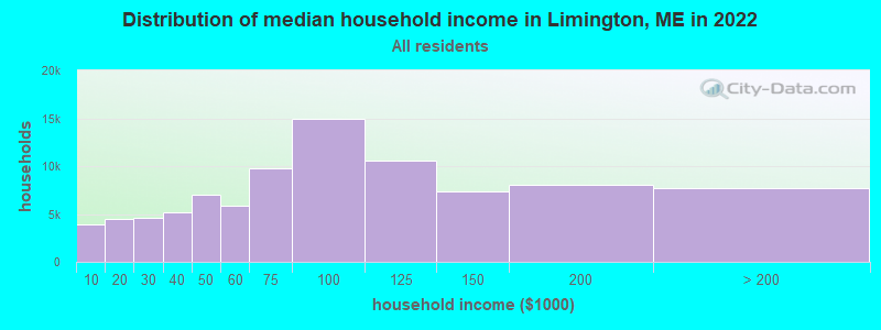
| Limington: | $78,910 |
| ME: | $69,543 |
Estimated per capita income in 2022: $34,782 (it was $17,097 in 2000)
Limington town income, earnings, and wages data
Estimated median house or condo value in 2022: $307,276 (it was $96,200 in 2000)
| Limington: | $307,276 |
| ME: | $290,600 |
Mean prices in 2022: all housing units: $451,552; detached houses: $470,451; townhouses or other attached units: $577,335; in 2-unit structures: $383,179; in 3-to-4-unit structures: $310,696; in 5-or-more-unit structures: $252,113; mobile homes: $105,501
Detailed information about poverty and poor residents in Limington, ME
Compare current foreclosures near Limington, ME:
| Photo | Address | Area | Beds / Baths | Price | Details |
|---|---|---|---|---|---|

|
#1
Cape Rd
Limington, ME 04049
|
- sq. feet
|
- baths - beds |
show details | |

|
#2
Harlan Dr
Limington, ME 04049
|
- sq. feet
|
- baths - beds |
show details | |

|
#3
Sokokis Ave
Limington, ME 04049
|
- sq. feet
|
- baths - beds |
show details | |

|
#4
Motorcycle Dr
Windham, ME 04062
|
2,772 sq. feet
|
2 baths 3 beds |
show details | |

|
#5
Webbs Mills Rd
Raymond, ME 04071
|
2,457 sq. feet
|
2 baths 4 beds |
show details | |

|
#6
High St
Windham, ME 04062
|
933 sq. feet
|
1 baths 2 beds |
show details | |

|
#7
Dollys Way
Scarborough, ME 04074
|
1,821 sq. feet
|
2 baths 3 beds |
show details | |

|
#8
Running Brook Rd
Windham, ME 04062
|
1,749 sq. feet
|
2 baths 3 beds |
show details | |

|
#9
Ring Landing Rd
Casco, ME 04015
|
1,296 sq. feet
|
1 baths 3 beds |
show details | |

|
#10
Emerson Dr
Windham, ME 04062
|
1,080 sq. feet
|
1 baths 3 beds |
show details |
| Photo | Address | Area | Beds / Baths | Price | Details |
|---|---|---|---|---|---|

|
#11
Main St
Gorham, ME 04038
|
691 sq. feet
|
1 baths 2 beds |
show details | |

|
#12
Windham Center Rd
Windham, ME 04062
|
1,576 sq. feet
|
1 baths 3 beds |
show details | |

|
#13
Saco St Unit 2
Westbrook, ME 04092
|
1,725 sq. feet
|
2 baths 4 beds |
show details | |

|
#14
Jennifer Way
Gorham, ME 04038
|
1,414 sq. feet
|
1 baths 3 beds |
show details | |

|
#15
Goldie Ln
Standish, ME 04084
|
2,273 sq. feet
|
1 baths 3 beds |
show details | |

|
#16
College Ave # 125
Gorham, ME 04038
|
- sq. feet
|
- baths - beds |
show details | |

|
#17
Webster Rd
Buxton, ME 04093
|
- sq. feet
|
- baths - beds |
show details | |

|
#18
Emma Ln
Gorham, ME 04038
|
- sq. feet
|
- baths - beds |
show details | |

|
#19
Hooper Rd
Shapleigh, ME 04076
|
528 sq. feet
|
- baths - beds |
show details | |

|
#20
Basswood St
Alfred, ME 04002
|
- sq. feet
|
- baths - beds |
show details |
| Photo | Address | Area | Beds / Baths | Price | Details |
|---|---|---|---|---|---|

|
#21
Ross Corner Rd
Shapleigh, ME 04076
|
- sq. feet
|
- baths - beds |
show details | |

|
#22
Narragansett Trl
Buxton, ME 04093
|
- sq. feet
|
- baths - beds |
show details | |

|
#23
Tall Pines Ln
Parsonsfield, ME 04047
|
- sq. feet
|
- baths - beds |
show details | |

|
#24
Sebago Rd
Sebago, ME 04029
|
- sq. feet
|
- baths - beds |
show details | |

|
#25
New Dam Rd
North Waterboro, ME 04061
|
- sq. feet
|
- baths - beds |
show details | |

|
#26
Elm St
Limerick, ME 04048
|
- sq. feet
|
- baths - beds |
show details | |

|
Check over 1 million property listings on Foreclosure.com!
|
browse all offers | |||

- 3,56195.9%White alone
- 571.5%Two or more races
- 441.2%Hispanic
- 180.5%Asian alone
- 120.3%American Indian alone
- 80.2%Black alone
- 80.2%Other race alone
- 50.1%Native Hawaiian and Other
Pacific Islander alone
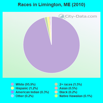
Races in Limington detailed stats: ancestries, foreign born residents, place of birth
According to our research of Maine and other state lists, there were 9 registered sex offenders living in Limington, Maine as of May 28, 2024.
The ratio of all residents to sex offenders in Limington is 413 to 1.
 Recent articles from our blog. Our writers, many of them Ph.D. graduates or candidates, create easy-to-read articles on a wide variety of topics.

 | Moving to ME from Hawaii (10 replies) |
| 2 tornado touchdowns in 2 weeks? (17 replies) |
| The best place to live in Maine. (394 replies) |
| moving north and looking for low cost of living (56 replies) |
| What's it like to live in Porter, ME? (10 replies) |
| Help Buying a House? (197 replies) |
Latest news from Limington, ME collected exclusively by city-data.com from local newspapers, TV, and radio stations
Ancestries: English (17.0%), Irish (14.1%), United States (13.8%), French (13.6%), German (6.7%), French Canadian (6.0%).
Current Local Time: EST time zone
Incorporated on 02/09/1792
Elevation: 474 feet
Land area: 42.0 square miles.
Population density: 88 people per square mile (very low).
42 residents are foreign born
| This town: | 1.2% |
| Maine: | 2.9% |
| Limington town: | 1.2% ($1,171) |
| Maine: | 1.5% ($1,417) |
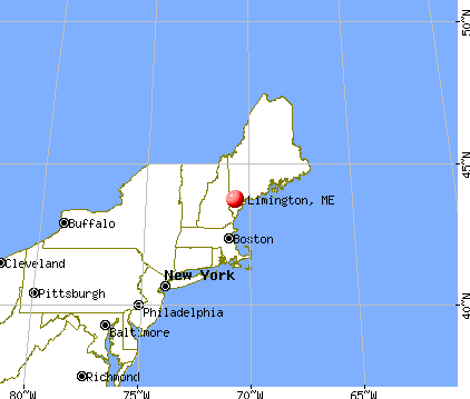
Nearest city with pop. 50,000+: Portland, ME  (22.2 miles , pop. 64,249).
Nearest city with pop. 200,000+: Boston, MA (99.6 miles , pop. 589,141).
Nearest city with pop. 1,000,000+: Bronx, NY (257.2 miles , pop. 1,332,650).
Nearest cities:
), ), )Latitude: 43.73 N, Longitude: 70.70 W
Area code: 207

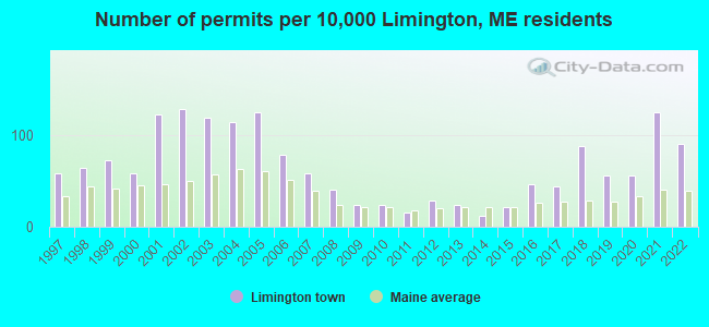
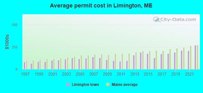
Single-family new house construction building permits:
- 2022: 31 buildings, average cost: $274,200
- 2021: 43 buildings, average cost: $209,500
- 2020: 19 buildings, average cost: $212,600
- 2019: 19 buildings, average cost: $193,300
- 2018: 30 buildings, average cost: $179,500
- 2017: 15 buildings, average cost: $175,000
- 2016: 16 buildings, average cost: $128,800
- 2015: 7 buildings, average cost: $178,000
- 2014: 4 buildings, average cost: $193,800
- 2013: 8 buildings, average cost: $160,600
- 2012: 10 buildings, average cost: $96,500
- 2011: 5 buildings, average cost: $92,000
- 2010: 8 buildings, average cost: $98,900
- 2009: 8 buildings, average cost: $110,100
- 2008: 14 buildings, average cost: $128,700
- 2007: 20 buildings, average cost: $141,400
- 2006: 27 buildings, average cost: $126,900
- 2005: 43 buildings, average cost: $118,400
- 2004: 39 buildings, average cost: $128,500
- 2003: 41 buildings, average cost: $116,400
- 2002: 44 buildings, average cost: $104,400
- 2001: 42 buildings, average cost: $101,900
- 2000: 20 buildings, average cost: $87,800
- 1999: 25 buildings, average cost: $88,000
- 1998: 22 buildings, average cost: $67,000
- 1997: 20 buildings, average cost: $84,200
| Here: | 3.4% |
| Maine: | 3.4% |
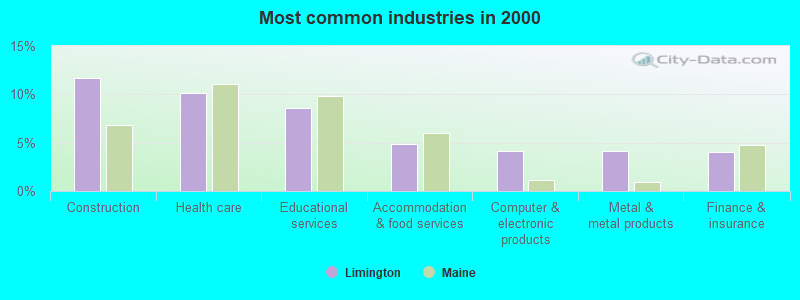
- Construction (11.7%)
- Health care (10.1%)
- Educational services (8.6%)
- Accommodation & food services (4.8%)
- Computer & electronic products (4.2%)
- Metal & metal products (4.1%)
- Finance & insurance (4.1%)
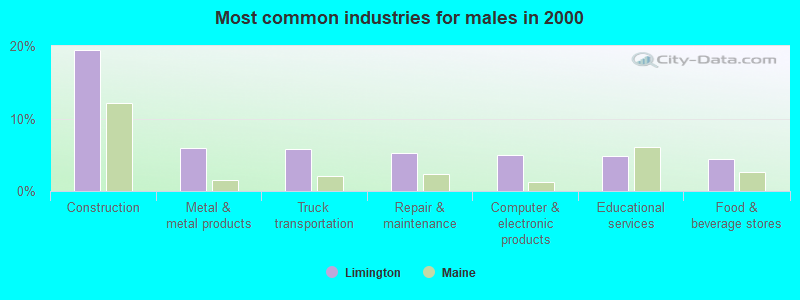
- Construction (19.5%)
- Metal & metal products (6.0%)
- Truck transportation (5.9%)
- Repair & maintenance (5.2%)
- Computer & electronic products (5.0%)
- Educational services (4.8%)
- Food & beverage stores (4.5%)
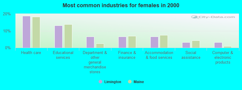
- Health care (18.8%)
- Educational services (13.2%)
- Department & other general merchandise stores (6.5%)
- Finance & insurance (6.5%)
- Accommodation & food services (6.5%)
- Social assistance (3.2%)
- Computer & electronic products (3.2%)
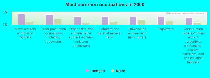
- Metal workers and plastic workers (5.1%)
- Other production occupations, including supervisors (4.9%)
- Other office and administrative support workers, including supervisors (4.0%)
- Laborers and material movers, hand (3.9%)
- Driver/sales workers and truck drivers (3.8%)
- Carpenters (3.8%)
- Construction traders workers except carpenters, electricians, painters, plumbers, and construction laborers (3.5%)
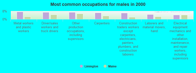
- Metal workers and plastic workers (7.6%)
- Driver/sales workers and truck drivers (7.0%)
- Other production occupations, including supervisors (6.9%)
- Carpenters (6.6%)
- Construction traders workers except carpenters, electricians, painters, plumbers, and construction laborers (6.4%)
- Laborers and material movers, hand (4.8%)
- Electrical equipment mechanics and other installation, maintenance, and repair workers, including supervisors (4.5%)

- Other office and administrative support workers, including supervisors (6.3%)
- Preschool, kindergarten, elementary, and middle school teachers (5.8%)
- Secretaries and administrative assistants (5.5%)
- Registered nurses (5.0%)
- Cashiers (4.9%)
- Other teachers, instructors, education, training, and library occupations (4.2%)
- Nursing, psychiatric, and home health aides (3.6%)
Average climate in Limington, Maine
Based on data reported by over 4,000 weather stations


(lower is better)
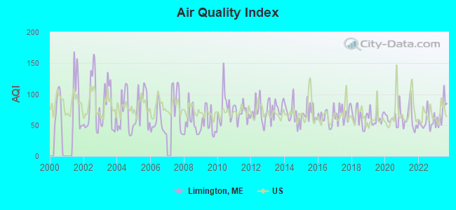
Air Quality Index (AQI) level in 2023 was 70.1. This is about average.
| City: | 70.1 |
| U.S.: | 72.6 |
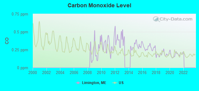
Carbon Monoxide (CO) [ppm] level in 2021 was 0.192. This is better than average. Closest monitor was 22.3 miles away from the city center.
| City: | 0.192 |
| U.S.: | 0.251 |
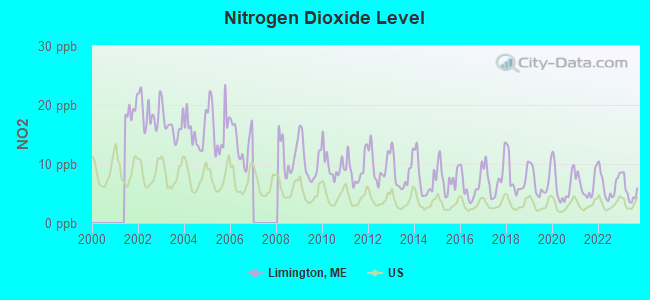
Nitrogen Dioxide (NO2) [ppb] level in 2023 was 5.47. This is about average. Closest monitor was 22.3 miles away from the city center.
| City: | 5.47 |
| U.S.: | 5.11 |
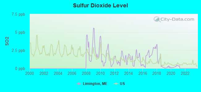
Sulfur Dioxide (SO2) [ppb] level in 2020 was 0.222. This is significantly better than average. Closest monitor was 17.3 miles away from the city center.
| City: | 0.222 |
| U.S.: | 1.515 |

Ozone [ppb] level in 2023 was 28.6. This is about average. Closest monitor was 6.5 miles away from the city center.
| City: | 28.6 |
| U.S.: | 33.3 |

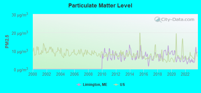
Particulate Matter (PM2.5) [µg/m3] level in 2023 was 6.48. This is better than average. Closest monitor was 17.2 miles away from the city center.
| City: | 6.48 |
| U.S.: | 8.11 |
Tornado activity:
Limington-area historical tornado activity is above Maine state average. It is 73% smaller than the overall U.S. average.
On 10/10/1966, a category F2 (max. wind speeds 113-157 mph) tornado 21.4 miles away from the Limington town center caused between $5000 and $50,000 in damages.
On 7/18/1963, a category F2 tornado 26.6 miles away from the town center caused between $5000 and $50,000 in damages.
Earthquake activity:
Limington-area historical earthquake activity is significantly above Maine state average. It is 74% smaller than the overall U.S. average.On 10/16/2012 at 23:12:25, a magnitude 4.7 (4.7 ML, Depth: 10.0 mi, Class: Light, Intensity: IV - V) earthquake occurred 9.7 miles away from the city center
On 4/20/2002 at 10:50:47, a magnitude 5.3 (5.3 ML, Depth: 3.0 mi, Class: Moderate, Intensity: VI - VII) earthquake occurred 158.1 miles away from the city center
On 1/19/1982 at 00:14:42, a magnitude 4.7 (4.5 MB, 4.7 MD, 4.5 LG) earthquake occurred 47.8 miles away from Limington center
On 4/20/2002 at 10:50:47, a magnitude 5.2 (5.2 MB, 4.2 MS, 5.2 MW, 5.0 MW) earthquake occurred 158.5 miles away from the city center
On 10/7/1983 at 10:18:46, a magnitude 5.3 (5.1 MB, 5.3 LG, 5.1 ML) earthquake occurred 182.2 miles away from Limington center
On 8/21/1996 at 07:54:14, a magnitude 3.8 (3.8 LG, 3.6 LG, Depth: 6.2 mi, Class: Light, Intensity: II - III) earthquake occurred 44.9 miles away from Limington center
Magnitude types: regional Lg-wave magnitude (LG), body-wave magnitude (MB), duration magnitude (MD), local magnitude (ML), surface-wave magnitude (MS), moment magnitude (MW)
Natural disasters:
The number of natural disasters in York County (31) is a lot greater than the US average (15).Major Disasters (Presidential) Declared: 23
Emergencies Declared: 8
Causes of natural disasters: Floods: 21, Storms: 16, Winter Storms: 6, Snows: 5, Winds: 3, Heavy Rains: 2, Hurricanes: 2, Blizzard: 1, Ice Storm: 1, Mudslide: 1, Snowfall: 1, Snowstorm: 1, Tornado: 1, Tropical Storm: 1 (Note: some incidents may be assigned to more than one category).

Airports located in Limington:
- Limington-Harmon Airport (63B) (Runways: 1, Itinerant Ops: 2,500, Local Ops: 10,000, Military Ops: 3)
Colleges/universities with over 2000 students nearest to Limington:
- Saint Joseph's College of Maine (about 13 miles; Standish, ME; Full-time enrollment: 2,010)
- University of Southern Maine (about 22 miles; Portland, ME; FT enrollment: 6,647)
- Southern Maine Community College (about 25 miles; South Portland, ME; FT enrollment: 4,666)
- University of New England (about 25 miles; Biddeford, ME; FT enrollment: 4,539)
- University of New Hampshire-Main Campus (about 44 miles; Durham, NH; FT enrollment: 15,243)
- Plymouth State University (about 50 miles; Plymouth, NH; FT enrollment: 4,838)
- NHTI-Concord's Community College (about 55 miles; Concord, NH; FT enrollment: 2,865)
Public elementary/middle school in Limington:
- H B EMERY JR MEMORIAL SCHOOL (Location: 908 CAPE ROAD, Grades: PK-5)
Points of interest:
Notable locations in Limington: Davis Memorial Library (A), Limington Fire and Emergency Medical Services (B), Limington Volunteer Fire Department Station 2 (C). Display/hide their locations on the map
Church in Limington: Limington Congregation Church (A). Display/hide its location on the map
Cemeteries: Marrs Cemetery (1), Gordon Cemetery (2), Cole Cemeteries (3). Display/hide their locations on the map
Lakes, reservoirs, and swamps: Wards Pond (A), Boyd Pond (B), Doles Pond (C), Dollar Pond (D), Foss Ponds (E), Sand Pond (F), Horne Pond (G), Webster Millpond (H). Display/hide their locations on the map
Streams, rivers, and creeks: Back Brook (A), Hamlin Brook (B), Pease Brook (C), Horse Pond Brook (D), Little Ossipee River (E), Black Brook (F). Display/hide their locations on the map
Tourist attraction: Riverbend Guide Service (Tours & Charters; 793 Sokokis Avenue) (1). Display/hide its approximate location on the map
Drinking water stations with addresses in Limington and their reported violations in the past:
RUNWAY RESTAURANT (Population served: 150, Groundwater):Past monitoring violations:
- 14 routine major monitoring violations
| This town: | 2.7 people |
| Maine: | 2.3 people |
| This town: | 73.9% |
| Whole state: | 62.9% |
| This town: | 9.5% |
| Whole state: | 9.4% |
Likely homosexual households (counted as self-reported same-sex unmarried-partner households)
- Lesbian couples: 0.4% of all households
- Gay men: 0.3% of all households
| This town: | 12.9% |
| Whole state: | 10.9% |
| This town: | 5.2% |
| Whole state: | 4.1% |
People in group quarters in Limington in 2000:
- 133 people in nursing homes
- 26 people in other noninstitutional group quarters
- 3 people in homes for the mentally retarded
- 3 people in other group homes
For population 15 years and over in Limington:

- Never married: 23.9%
- Now married: 57.0%
- Separated: 0.9%
- Widowed: 7.0%
- Divorced: 11.3%
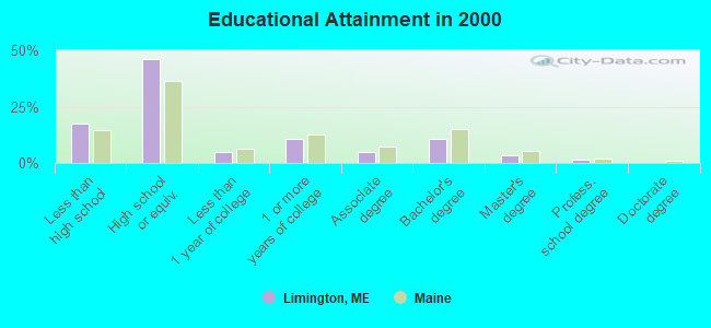
For population 25 years and over in Limington:
- High school or higher: 82.5%
- Bachelor's degree or higher: 15.5%
- Graduate or professional degree: 5.0%
- Unemployed: 4.1%
- Mean travel time to work (commute): 34.0 minutes

| Here: | 10.3 |
| Maine average: | 11.2 |


Graphs represent county-level data. Detailed 2008 Election Results
Religion statistics for Limington, ME (based on York County data)
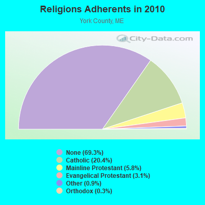

| Religion | Adherents | Congregations |
|---|---|---|
| Catholic | 40,283 | 16 |
| Mainline Protestant | 11,480 | 64 |
| Evangelical Protestant | 6,086 | 51 |
| Other | 1,847 | 18 |
| Orthodox | 625 | 3 |
| Black Protestant | 119 | 1 |
| None | 136,691 | - |
Food Environment Statistics:
| Here: | 2.24 / 10,000 pop. |
| Maine: | 2.80 / 10,000 pop. |
| Here: | 0.05 / 10,000 pop. |
| Maine: | 0.14 / 10,000 pop. |
| York County: | 2.09 / 10,000 pop. |
| Maine: | 2.20 / 10,000 pop. |
| York County: | 4.23 / 10,000 pop. |
| Maine: | 5.75 / 10,000 pop. |
| York County: | 12.53 / 10,000 pop. |
| State: | 11.02 / 10,000 pop. |
| York County: | 7.7% |
| State: | 8.2% |
| This county: | 24.0% |
| Maine: | 25.0% |
Strongest AM radio stations in Limington:
- WMTW (870 AM; 10 kW; GORHAM, ME; Owner: RADIO PARTNERS OF MAINE, L.P.)
- WGAN (560 AM; 5 kW; PORTLAND, ME; Owner: SAGA COMMUNICATIONS OF NEW ENGLAND, LLC)
- WJAE (1440 AM; 5 kW; WESTBROOK, ME; Owner: ALTANTIC COAST RADIO, LLC)
- WZAN (970 AM; 5 kW; PORTLAND, ME; Owner: SAGA COMMUNICATIONS OF NEW ENGLAND, LLC)
- WLOB (1310 AM; 5 kW; PORTLAND, ME; Owner: ATLANTIC COAST RADIO, LLC)
- WGIN (930 AM; 10 kW; ROCHESTER, NH; Owner: CAPSTAR TX LIMITED PARTNERSHIP)
- WRKO (680 AM; 50 kW; BOSTON, MA; Owner: ENTERCOM BOSTON LICENSE, LLC)
- WEEI (850 AM; 50 kW; BOSTON, MA; Owner: ENTERCOM BOSTON LICENSE, LLC)
- WBZ (1030 AM; 50 kW; BOSTON, MA; Owner: INFINITY BROADCASTING OPERATIONS, INC.)
- WASR (1420 AM; 5 kW; WOLFEBORO, NH; Owner: RADIO WOLFEBORO, INC.)
- WTME (780 AM; 10 kW; RUMFORD, ME; Owner: MOUNTAIN VALLEY BROADCASTING, INC.)
- WCRN (830 AM; 50 kW; WORCESTER, MA; Owner: CARTER BROADCASTING CORPORATION)
- WKOX (1200 AM; 50 kW; FRAMINGHAM, MA; Owner: CAPSTAR TX LIMITED PARTNERSHIP)
Strongest FM radio stations in Limington:
- WMEA (90.1 FM; PORTLAND, ME; Owner: MAINE PUBLIC BROADCASTING CORPORATION)
- WBLM (102.9 FM; PORTLAND, ME; Owner: CITADEL BROADCASTING COMPANY)
- WPKQ (103.7 FM; NORTH CONWAY, NH; Owner: CITADEL BROADCASTING COMPANY)
- WHOM (94.9 FM; MT. WASHINGTON, NH; Owner: CITADEL BROADCASTING COMPANY)
- WSCY (106.9 FM; MOULTONBOROUGH, NH; Owner: NORTHEAST COMMUNICATIONS CORPORATION)
- WJBQ (97.9 FM; PORTLAND, ME; Owner: CITADEL BROADCASTING COMPANY)
- WTHT (107.5 FM; LEWISTON, ME; Owner: RADIO PARTNERS OF MAINE, L.P.)
- WVFM (105.7 FM; CAMPTON, NH; Owner: DEVON BROADCASTING COMPANY, INC.)
- WPOR (101.9 FM; PORTLAND, ME; Owner: SAGA COMMUNICATIONS OF NEW ENGLAND, LLC)
- WMTW-FM (106.7 FM; NORTH WINDHAM, ME; Owner: RADIO PARTNERS OF MAINE, L.P.)
- WMSJ (89.3 FM; FREEPORT, ME; Owner: DOWNEAST CHRISTIAN COMMUNICATIONS)
- WPHX-FM (92.1 FM; SANFORD, ME; Owner: FNX BROADCASTING LLC)
- WSEW (88.5 FM; SANFORD, ME; Owner: WORD RADIO EDUCATIONAL FOUNDATION)
- WCYY (94.3 FM; BIDDEFORD, ME; Owner: CITADEL BROADCASTING COMPANY)
- WLKZ (104.9 FM; WOLFEBORO, NH; Owner: TELE-MEDIA COMPANY OF NEW HAMPSHIRE, L.L.C.)
- WMEK-FM (99.9 FM; AUBURN, ME; Owner: RADIO PARTNERS OF MAINE, L.P.)
- WRED (95.9 FM; SACO, ME; Owner: ATLANTIC COAST RADIO, LLC)
- WMPG (90.9 FM; GORHAM, ME; Owner: UNIVERSITY OF MAINE SYSTEM)
- WMEX (106.5 FM; FARMINGTON, NH; Owner: WIMMEX, LLC)
- WMGX (93.1 FM; PORTLAND, ME; Owner: SAGA COMMUNICATIONS OF NEW ENGLAND, LLC)
TV broadcast stations around Limington:
- WMTW-TV (Channel 8; POLAND SPRING, ME; Owner: WMTW BROADCAST GROUP, LLC)
- WCSH (Channel 6; PORTLAND, ME; Owner: PACIFIC AND SOUTHERN COMPANY, INC.)
- WGME-TV (Channel 13; PORTLAND, ME; Owner: WGME LICENSEE, LLC)
- WMEA-TV (Channel 26; BIDDEFORD, ME; Owner: MAINE PUBLIC BROADCASTING CORP.)
- WPXT (Channel 51; PORTLAND, ME; Owner: HMW, INC.)
- WPME (Channel 35; LEWISTON, ME; Owner: KB PRIME MEDIA LLC)
- W32CA (Channel 32; PORTLAND, ME; Owner: NATIONAL MINORITY T.V., INC.)
- W58CM (Channel 58; BANGOR, ME; Owner: MS COMMUNICATIONS, LLC)
- W57AP (Channel 57; FALMOUTH, ME; Owner: SHERWOOD H. CRAIG)
- WLLB-LP (Channel 15; PORTLAND, ME; Owner: CARTER BROADCASTING CORPORATION)
- National Bridge Inventory (NBI) Statistics
- 5Number of bridges
- 46ft / 13.9mTotal length
- 12,446Total average daily traffic
- 621Total average daily truck traffic
- 17,726Total future (year 2036) average daily traffic
FCC Registered Antenna Towers:
15 (See the full list of FCC Registered Antenna Towers in Limington)FCC Registered Microwave Towers:
1- Limington St, 162 Sokokis Ave (Lat: 43.717667 Lon: -70.725806), Type: Mtower, Structure height: 45.7 m, Call Sign: WQSV266,
Assigned Frequencies: 10775.0 MHz, Grant Date: 10/17/2023, Expiration Date: 11/20/2033, Certifier: John E Monday, Registrant: At&t Services, Inc., 208 S Akard St, 20f, Dallas, TX 75202, Phone: (855) 699-7073, Email:
FCC Registered Amateur Radio Licenses:
19 (See the full list of FCC Registered Amateur Radio Licenses in Limington)FAA Registered Aircraft:
11 (See the full list of FAA Registered Aircraft in Limington)2004 - 2018 National Fire Incident Reporting System (NFIRS) incidents
- Fire incident types reported to NFIRS in Limington, ME
- 10846.6%Structure Fires
- 8737.5%Outside Fires
- 208.6%Mobile Property/Vehicle Fires
- 177.3%Other
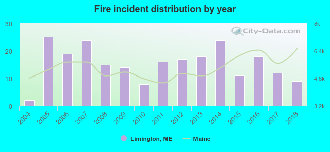 According to the data from the years 2004 - 2018 the average number of fire incidents per year is 15. The highest number of fires - 25 took place in 2005, and the least - 2 in 2004. The data has a growing trend.
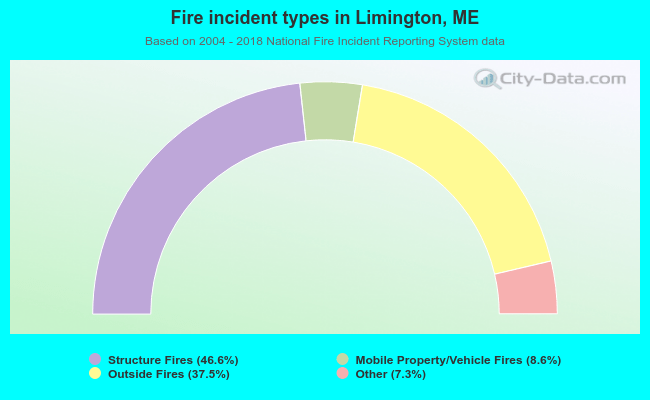 When looking into fire subcategories, the most reports belonged to: Structure Fires (46.6%), and Outside Fires (37.5%).
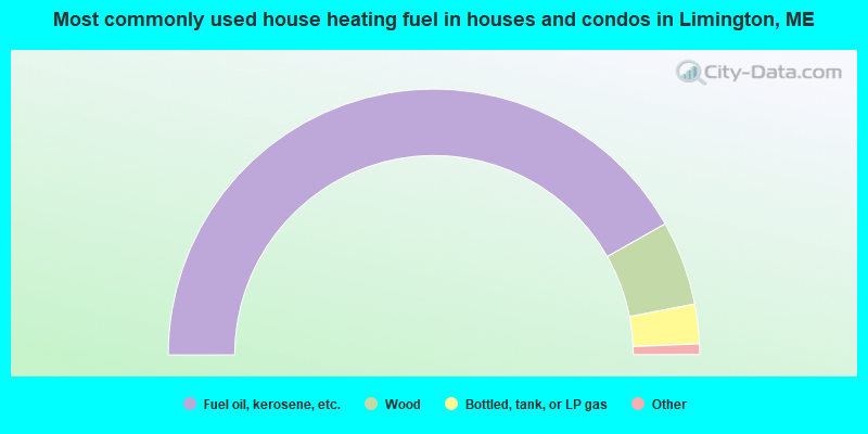
- 83.6%Fuel oil, kerosene, etc.
- 10.3%Wood
- 4.8%Bottled, tank, or LP gas
- 0.9%Utility gas
- 0.4%Other fuel

- 91.6%Fuel oil, kerosene, etc.
- 5.4%Bottled, tank, or LP gas
- 3.0%Electricity
Limington compared to Maine state average:
- Unemployed percentage significantly below state average.
- Black race population percentage significantly below state average.
- Median age below state average.
- Foreign-born population percentage significantly below state average.
- Renting percentage below state average.
- Length of stay since moving in significantly above state average.
- Number of rooms per house significantly below state average.
- House age significantly below state average.
- Institutionalized population percentage above state average.
- Number of college students below state average.
- Percentage of population with a bachelor's degree or higher below state average.

|
Total of 11 patent applications in 2008-2024.