Lenhartsville, Pennsylvania
Submit your own pictures of this borough and show them to the world
- OSM Map
- General Map
- Google Map
- MSN Map

Population change since 2000: +2.9%
 |
| Males: 78 | |
| Females: 100 |
| Median resident age: | 38.0 years |
| Pennsylvania median age: | 40.9 years |
Zip code: 19534
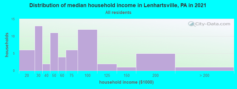
| Lenhartsville: | $61,876 |
| PA: | $71,798 |
Estimated per capita income in 2022: $31,415 (it was $16,998 in 2000)
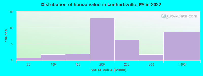
Estimated median house or condo value in 2022: $212,130 (it was $84,600 in 2000)
| Lenhartsville: | $212,130 |
| PA: | $245,500 |
Mean prices in 2022: all housing units: $257,920; detached houses: $280,901; townhouses or other attached units: $176,105
Median gross rent in 2022: $937.
Detailed information about poverty and poor residents in Lenhartsville, PA
Compare current foreclosures near Lenhartsville, PA:
| Photo | Address | Area | Beds / Baths | Price | Details |
|---|---|---|---|---|---|

|
#1
Rd
Lenhartsville, PA 19534
|
- sq. feet
|
- baths - beds |
show details | |

|
#2
Donat Rd
Lenhartsville, PA 19534
|
- sq. feet
|
- baths - beds |
show details | |

|
#3
Ash Cir
Andreas, PA 18211
|
988 sq. feet
|
1 baths 2 beds |
$24,215
|
show details |

|
#4
S Margaretta St
Schuylkill Haven, PA 17972
|
1,264 sq. feet
|
1 baths 3 beds |
$114,614
|
show details |

|
#5
Parkway
Schuylkill Haven, PA 17972
|
1,428 sq. feet
|
1 baths 3 beds |
$85,871
|
show details |

|
#6
Grey Hawk Dr
Orwigsburg, PA 17961
|
2,240 sq. feet
|
2 baths 3 beds |
$266,560
|
show details |

|
#7
Orwigsburg St
Tamaqua, PA 18252
|
1,455 sq. feet
|
1 baths 3 beds |
$47,280
|
show details |

|
#8
Chestnut Rd
Orwigsburg, PA 17961
|
1,674 sq. feet
|
1 baths 3 beds |
$4,256
|
show details |

|
#9
Hazle St
Tamaqua, PA 18252
|
1,576 sq. feet
|
1 baths 3 beds |
$69,864
|
show details |

|
#10
Linden St
Reading, PA 19604
|
1,236 sq. feet
|
1 baths 3 beds |
$40,706
|
show details |
| Photo | Address | Area | Beds / Baths | Price | Details |
|---|---|---|---|---|---|

|
#11
Market St
Tamaqua, PA 18252
|
1,265 sq. feet
|
1 baths 3 beds |
$63,376
|
show details |

|
#12
Pottsville St
Cressona, PA 17929
|
1,308 sq. feet
|
1 baths 3 beds |
$108,472
|
show details |

|
#13
Graeff St
Cressona, PA 17929
|
1,176 sq. feet
|
1 baths 2 beds |
$94,435
|
show details |

|
#14
Callery Dr
Blandon, PA 19510
|
1,616 sq. feet
|
2 baths 3 beds |
$188,265
|
show details |

|
#15
E Liberty St
Schuylkill Haven, PA 17972
|
1,176 sq. feet
|
1 baths 3 beds |
$106,662
|
show details |

|
#16
Wilshire Rd
Temple, PA 19560
|
1,272 sq. feet
|
1 baths 4 beds |
show details | |

|
#17
Washington Street
Auburn, PA 17922
|
1,526 sq. feet
|
1 baths 2 beds |
show details | |

|
#18
Rivervale Rd
Reading, PA 19605
|
3,036 sq. feet
|
3 baths 4 beds |
show details | |

|
#19
Washington St
Topton, PA 19562
|
1,204 sq. feet
|
1 baths 3 beds |
show details | |

|
#20
Chestnut St
Reading, PA 19605
|
964 sq. feet
|
1 baths 2 beds |
show details |
| Photo | Address | Area | Beds / Baths | Price | Details |
|---|---|---|---|---|---|

|
#21
Frush Valley Rd
Reading, PA 19605
|
1,040 sq. feet
|
1 baths 3 beds |
show details | |

|
#22
W Church St
Orwigsburg, PA 17961
|
1,620 sq. feet
|
1 baths 3 beds |
show details | |

|
#23
Willow Rd
Fleetwood, PA 19522
|
1,604 sq. feet
|
2 baths 4 beds |
show details | |

|
#24
N Canal St
Leesport, PA 19533
|
1,140 sq. feet
|
1 baths 3 beds |
show details | |

|
#25
Girard Ave
Reading, PA 19605
|
1,309 sq. feet
|
1 baths 3 beds |
show details | |

|
#26
W Columbia St
Schuylkill Haven, PA 17972
|
1,129 sq. feet
|
1 baths 2 beds |
show details | |

|
#27
Washington St
Middleport, PA 17953
|
- sq. feet
|
1 baths 2 beds |
show details | |

|
#28
Baltzer Ave
Bernville, PA 19506
|
- sq. feet
|
2 baths 4 beds |
show details | |

|
#29
Benfield Rd
Macungie, PA 18062
|
1,400 sq. feet
|
1 baths 3 beds |
show details | |

|
#30
N Front St
Reading, PA 19601
|
1,897 sq. feet
|
2 baths 4 beds |
show details |
| Photo | Address | Area | Beds / Baths | Price | Details |
|---|---|---|---|---|---|

|
#31
Comanche Dr
Auburn, PA 17922
|
2,177 sq. feet
|
2 baths 3 beds |
show details | |

|
#32
Willow St
Schuylkill Haven, PA 17972
|
1,316 sq. feet
|
1 baths 3 beds |
show details | |

|
#33
Lincoln St
Reading, PA 19601
|
1,372 sq. feet
|
1 baths 2 beds |
show details | |

|
#34
N Garfield Ave
Schuylkill Haven, PA 17972
|
904 sq. feet
|
1 baths 2 beds |
show details | |

|
#35
Hatchet Cv
Auburn, PA 17922
|
1,260 sq. feet
|
2 baths 4 beds |
show details | |

|
#36
Friedensburg Rd
Reading, PA 19606
|
1,084 sq. feet
|
1 baths 3 beds |
show details | |

|
#37
Pear St
Reading, PA 19601
|
1,573 sq. feet
|
1 baths 3 beds |
show details | |

|
#38
Grove St
Cressona, PA 17929
|
2,202 sq. feet
|
2 baths 5 beds |
show details | |

|
#39
George St
Pottsville, PA 17901
|
1,520 sq. feet
|
1 baths 2 beds |
show details | |

|
#40
Muhlenberg St
Reading, PA 19602
|
1,516 sq. feet
|
1 baths 4 beds |
show details |
| Photo | Address | Area | Beds / Baths | Price | Details |
|---|---|---|---|---|---|

|
#41
Laurel Rd
Orwigsburg, PA 17961
|
1,591 sq. feet
|
2 baths 3 beds |
show details | |

|
#42
S 15th St
Reading, PA 19602
|
2,086 sq. feet
|
1 baths 4 beds |
show details | |

|
#43
Moselem Spring Rd
Hamburg, PA 19526
|
1,056 sq. feet
|
2 baths 3 beds |
show details | |

|
#44
N 4th St
Hamburg, PA 19526
|
1,320 sq. feet
|
1 baths 3 beds |
show details | |

|
#45
Main St
Shoemakersville, PA 19555
|
1,936 sq. feet
|
1 baths 4 beds |
show details | |

|
#46
Blacksmith Rd
New Tripoli, PA 18066
|
4,251 sq. feet
|
5 baths 8 beds |
show details | |

|
#47
Best Station Rd
Slatington, PA 18080
|
1,044 sq. feet
|
1 baths 2 beds |
show details | |

|
#48
Mayo Dr
Reading, PA 19601
|
2,009 sq. feet
|
2 baths 3 beds |
show details | |

|
#49
Linden St
Reading, PA 19604
|
1,689 sq. feet
|
1 baths 4 beds |
show details | |

|
Check over 1 million property listings on Foreclosure.com!
|
browse all offers | |||


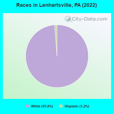
- 15995.8%White alone
- 21.2%Hispanic
According to our research of Pennsylvania and other state lists, there were 3 registered sex offenders living in Lenhartsville, Pennsylvania as of May 28, 2024.
The ratio of all residents to sex offenders in Lenhartsville is 55 to 1.
 Recent articles from our blog. Our writers, many of them Ph.D. graduates or candidates, create easy-to-read articles on a wide variety of topics.

 | PennDOT announces plans for tolls on I-79 bridge south of Pittsburgh (78 replies) |
| TV antenna in Lehigh Valley (11 replies) |
| Family camping areas near Philadelphia? (4 replies) |
| Terrible Road conditions on Route 78 (2 replies) |
Latest news from Lenhartsville, PA collected exclusively by city-data.com from local newspapers, TV, and radio stations
Ancestries: German (48.1%), Pennsylvania German (9.3%), Irish (7.4%), Polish (7.4%), American (3.7%), Dutch (1.9%).
Current Local Time: EST time zone
Incorporated in 1887
Elevation: 370 feet
Land area: 0.13 square miles.
Population density: 1,334 people per square mile (low).

4 residents are foreign born (2.4% Europe).
| This borough: | 2.4% |
| Pennsylvania: | 7.3% |
Median real estate property taxes paid for housing units with mortgages in 2022: $3,783 (1.5%)
Median real estate property taxes paid for housing units with no mortgage in 2022: $3,099 (1.6%)
Nearest city with pop. 50,000+: Reading, PA  (16.2 miles , pop. 81,207).
Nearest city with pop. 200,000+: Philadelphia, PA (55.8 miles , pop. 1,517,550).
Nearest cities:
), ), ), ), Latitude: 40.57 N, Longitude: 75.89 W

| Here: | 3.0% |
| Pennsylvania: | 2.9% |
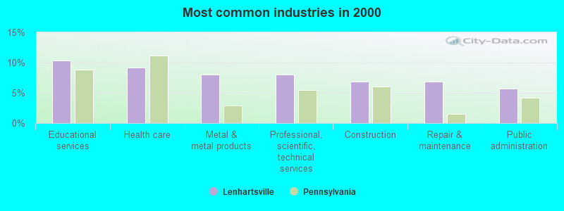
- Educational services (10.3%)
- Health care (9.2%)
- Metal & metal products (8.0%)
- Professional, scientific, technical services (8.0%)
- Construction (6.9%)
- Repair & maintenance (6.9%)
- Public administration (5.7%)
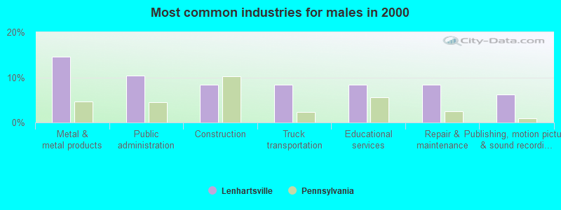
- Metal & metal products (14.6%)
- Public administration (10.4%)
- Construction (8.3%)
- Truck transportation (8.3%)
- Educational services (8.3%)
- Repair & maintenance (8.3%)
- Publishing, motion picture & sound recording industries (6.2%)

- Health care (20.5%)
- Professional, scientific, technical services (15.4%)
- Educational services (12.8%)
- Other direct selling establishments (7.7%)
- Agriculture, forestry, fishing & hunting (5.1%)
- Construction (5.1%)
- Music stores (5.1%)

- Other office and administrative support workers, including supervisors (9.2%)
- Other food preparation and serving workers, including supervisors (8.0%)
- Preschool, kindergarten, elementary, and middle school teachers (6.9%)
- Secretaries and administrative assistants (5.7%)
- Sales representatives, services, wholesale and manufacturing (4.6%)
- Vehicle and mobile equipment mechanics, installers, and repairers (4.6%)
- Assemblers and fabricators (4.6%)

- Sales representatives, services, wholesale and manufacturing (8.3%)
- Vehicle and mobile equipment mechanics, installers, and repairers (8.3%)
- Assemblers and fabricators (8.3%)
- Metal workers and plastic workers (8.3%)
- Preschool, kindergarten, elementary, and middle school teachers (6.2%)
- Other food preparation and serving workers, including supervisors (6.2%)
- Other sales and related occupations, including supervisors (6.2%)

- Other office and administrative support workers, including supervisors (15.4%)
- Secretaries and administrative assistants (12.8%)
- Other food preparation and serving workers, including supervisors (10.3%)
- Preschool, kindergarten, elementary, and middle school teachers (7.7%)
- Retail sales workers, except cashiers (7.7%)
- Information and record clerks, except customer service representatives (5.1%)
- Other health diagnosing and treating practitioners and technical occupations (5.1%)
Average climate in Lenhartsville, Pennsylvania
Based on data reported by over 4,000 weather stations


(lower is better)
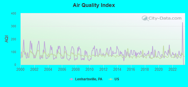
Air Quality Index (AQI) level in 2023 was 103. This is significantly worse than average.
| City: | 103 |
| U.S.: | 73 |
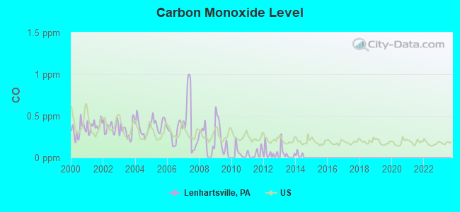
Carbon Monoxide (CO) [ppm] level in 2013 was 0.0450. This is significantly better than average. Closest monitor was 13.8 miles away from the city center.
| City: | 0.0450 |
| U.S.: | 0.2513 |
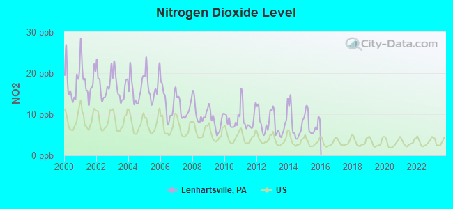
Nitrogen Dioxide (NO2) [ppb] level in 2015 was 7.80. This is significantly worse than average. Closest monitor was 6.8 miles away from the city center.
| City: | 7.80 |
| U.S.: | 5.11 |
Sulfur Dioxide (SO2) [ppb] level in 2023 was 0.247. This is significantly better than average. Closest monitor was 13.8 miles away from the city center.
| City: | 0.247 |
| U.S.: | 1.515 |
Ozone [ppb] level in 2022 was 30.6. This is about average. Closest monitor was 6.8 miles away from the city center.
| City: | 30.6 |
| U.S.: | 33.3 |
Particulate Matter (PM10) [µg/m3] level in 2022 was 13.0. This is significantly better than average. Closest monitor was 12.0 miles away from the city center.
| City: | 13.0 |
| U.S.: | 19.2 |
Particulate Matter (PM2.5) [µg/m3] level in 2023 was 14.4. This is significantly worse than average. Closest monitor was 12.7 miles away from the city center.
| City: | 14.4 |
| U.S.: | 8.1 |
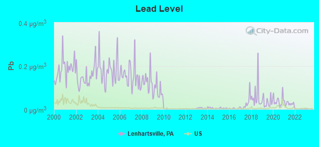
Lead (Pb) [µg/m3] level in 2021 was 0.0255. This is significantly worse than average. Closest monitor was 4.9 miles away from the city center.
| City: | 0.0255 |
| U.S.: | 0.0093 |
Tornado activity:
Lenhartsville-area historical tornado activity is slightly above Pennsylvania state average. It is 7% greater than the overall U.S. average.
On 5/31/1998, a category F3 (max. wind speeds 158-206 mph) tornado 6.5 miles away from the Lenhartsville borough center injured 7 people and caused $1 million in damages.
On 11/4/1950, a category F3 tornado 12.2 miles away from the borough center injured one person and caused between $50,000 and $500,000 in damages.
Earthquake activity:
Lenhartsville-area historical earthquake activity is significantly above Pennsylvania state average. It is 65% smaller than the overall U.S. average.On 8/23/2011 at 17:51:04, a magnitude 5.8 (5.8 MW, Depth: 3.7 mi, Class: Moderate, Intensity: VI - VII) earthquake occurred 214.5 miles away from the city center
On 1/16/1994 at 01:49:16, a magnitude 4.6 (4.6 MB, 4.6 LG, Depth: 3.1 mi, Class: Light, Intensity: IV - V) earthquake occurred 18.6 miles away from Lenhartsville center
On 1/16/1994 at 00:42:43, a magnitude 4.2 (4.2 MB, 4.0 LG, Depth: 3.1 mi) earthquake occurred 18.2 miles away from the city center
On 10/7/1983 at 10:18:46, a magnitude 5.3 (5.1 MB, 5.3 LG, 5.1 ML) earthquake occurred 246.8 miles away from the city center
On 9/25/1998 at 19:52:52, a magnitude 5.2 (4.8 MB, 4.3 MS, 5.2 LG, 4.5 MW, Depth: 3.1 mi) earthquake occurred 243.7 miles away from Lenhartsville center
On 4/20/2002 at 10:50:47, a magnitude 5.3 (5.3 ML, Depth: 3.0 mi) earthquake occurred 294.4 miles away from the city center
Magnitude types: regional Lg-wave magnitude (LG), body-wave magnitude (MB), local magnitude (ML), surface-wave magnitude (MS), moment magnitude (MW)
Natural disasters:
The number of natural disasters in Berks County (19) is greater than the US average (15).Major Disasters (Presidential) Declared: 15
Emergencies Declared: 4
Causes of natural disasters: Floods: 5, Storms: 5, Tropical Storms: 4, Hurricanes: 3, Winter Storms: 3, Snowstorms: 2, Blizzard: 1, Heavy Rain: 1, Mudslide: 1, Snowfall: 1, Tornado: 1, Water Shortage: 1, Other: 1 (Note: some incidents may be assigned to more than one category).

Hospitals and medical centers near Lenhartsville:
- LAUREL CENTER (Nursing Home, about 7 miles away; HAMBURG, PA)
- FRESENIUS MEDICAL CARE KUTZTOWN (Dialysis Facility, about 7 miles away; KUTZTOWN, PA)
- KUTZTOWN MANOR (Nursing Home, about 8 miles away; KUTZTOWN, PA)
- MANORCARE HEALTH SERVICES-LAURELDALE (Nursing Home, about 13 miles away; LAURELDALE, PA)
- LEADER NSG/REHAB LAURELDALE (Nursing Home, about 13 miles away; READING, PA)
- SETON MANOR INC (Nursing Home, about 14 miles away; ORWIGSBURG, PA)
- ODYSSEY HEALTHCARE OF ALLENTOWN (Hospital, about 15 miles away; ALLENTOWN, PA)
Colleges/universities with over 2000 students nearest to Lenhartsville:
- Kutztown University of Pennsylvania (about 7 miles; Kutztown, PA; Full-time enrollment: 9,099)
- Albright College (about 15 miles; Reading, PA; FT enrollment: 2,319)
- Pennsylvania State University-Penn State Berks (about 16 miles; Reading, PA; FT enrollment: 2,605)
- Lehigh Carbon Community College (about 16 miles; Schnecksville, PA; FT enrollment: 4,391)
- Reading Area Community College (about 17 miles; Reading, PA; FT enrollment: 2,941)
- Alvernia University (about 19 miles; Reading, PA; FT enrollment: 2,461)
- McCann School of Business & Technology (about 20 miles; Pottsville, PA; FT enrollment: 3,412)
Public elementary/middle school in Lenhartsville:
- GREENWICH-LENHARTSVILLE EL SCH (Students: 188, Location: 1457 SR 737 KRUMSVILLE RD, Grades: KG-5)
Points of interest:
Notable location: Lenhartsville Borough Hall (A). Display/hide its location on the map
Creek: Furnace Creek (A). Display/hide its location on the map
Hotel: Greg's Top Motel (1530 Krumsville Rd).
Drinking water stations with addresses in Lenhartsville and their reported violations in the past:
CHRISTMAN LAKE WATER SYSTEM (Population served: 80, Groundwater):Past monitoring violations:KRUMSVILLE INN (Population served: 65, Groundwater):
- 56 regular monitoring violations
Past health violations:ROBIN HILL CAMPGROUND (Population served: 50, Groundwater):
- MCL, Monthly (TCR) - In SEP-2011, Contaminant: Coliform. Follow-up actions: St Public Notif requested (OCT-31-2011), St Public Notif received (OCT-31-2011), St Compliance achieved (OCT-31-2011), St Formal NOV issued (OCT-31-2011)
- MCL, Monthly (TCR) - Between JUL-2011 and SEP-2011, Contaminant: Coliform. Follow-up actions: St Public Notif requested (SEP-26-2011), St Public Notif received (SEP-26-2011), St Compliance achieved (SEP-26-2011), St Formal NOV issued (SEP-26-2011)
- MCL, Monthly (TCR) - Between APR-2005 and JUN-2005, Contaminant: Coliform. Follow-up actions: St Public Notif requested (MAR-01-2006), St Public Notif received (MAR-01-2006), St Compliance achieved (MAR-01-2006), St Violation/Reminder Notice (MAR-01-2006)
Past health violations:RAUCHS SHELL FOOD MART (Population served: 25, Groundwater):
- MCL, Monthly (TCR) - Between OCT-2013 and DEC-2013, Contaminant: Coliform. Follow-up actions: St Public Notif requested (NOV-27-2013), St Formal NOV issued (NOV-27-2013), St Compliance achieved (JUL-15-2014), St Public Notif received (JUL-15-2014)
- MCL, Monthly (TCR) - In JUL-2013, Contaminant: Coliform. Follow-up actions: St Public Notif requested (SEP-04-2013), St Public Notif received (SEP-04-2013), St Compliance achieved (SEP-04-2013), St Violation/Reminder Notice (SEP-04-2013)
- MCL, Acute (TCR) - Between APR-2013 and JUN-2013, Contaminant: Coliform. Follow-up actions: St Public Notif requested (JUL-29-2013), St Violation/Reminder Notice (JUL-29-2013), St Public Notif received (AUG-01-2013), St Compliance achieved (JAN-06-2014)
- MCL, Monthly (TCR) - Between APR-2013 and JUN-2013, Contaminant: Coliform. Follow-up actions: St Public Notif requested (JUL-29-2013), St Violation/Reminder Notice (JUL-29-2013), St Public Notif received (AUG-01-2013), St Compliance achieved (AUG-13-2014)
Past health violations:Past monitoring violations:
- MCL, Monthly (TCR) - Between OCT-2013 and DEC-2013, Contaminant: Coliform. Follow-up actions: St Public Notif requested (NOV-21-2013), St Public Notif received (NOV-21-2013), St Compliance achieved (NOV-21-2013), St Formal NOV issued (NOV-21-2013)
- MCL, Monthly (TCR) - In JUL-2010, Contaminant: Coliform. Follow-up actions: St Public Notif received (SEP-08-2010), St Formal NOV issued (SEP-08-2010), St Compliance achieved (SEP-08-2010), St Public Notif requested (SEP-08-2010)
- MCL, Monthly (TCR) - Between APR-2010 and JUN-2010, Contaminant: Coliform. Follow-up actions: St Public Notif requested (JUL-29-2010), St Public Notif received (JUL-29-2010), St Compliance achieved (JUL-29-2010), St Formal NOV issued (JUL-29-2010)
- MCL, Monthly (TCR) - Between JUL-2009 and SEP-2009, Contaminant: Coliform. Follow-up actions: St Public Notif requested (OCT-28-2009), St Public Notif received (OCT-28-2009), St Compliance achieved (OCT-28-2009), St Formal NOV issued (OCT-28-2009)
- 2 regular monitoring violations
| This borough: | 2.3 people |
| Pennsylvania: | 2.5 people |
| This borough: | 59.2% |
| Whole state: | 65.0% |
| This borough: | 12.7% |
| Whole state: | 6.6% |
No gay or lesbian households reported
For population 15 years and over in Lenhartsville:
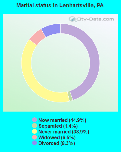
- Never married: 38.9%
- Now married: 44.9%
- Separated: 1.4%
- Widowed: 6.5%
- Divorced: 8.3%
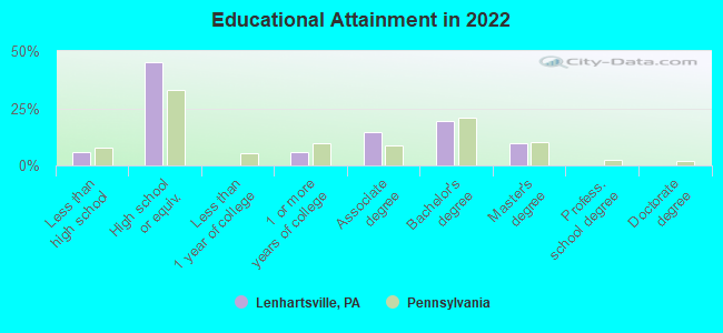
For population 25 years and over in Lenhartsville:
- High school or higher: 92.1%
- Bachelor's degree or higher: 28.1%
- Graduate or professional degree: 10.5%
- Unemployed: 5.4%
- Mean travel time to work (commute): 26.0 minutes

| Here: | 8.8 |
| Pennsylvania average: | 11.4 |
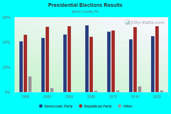
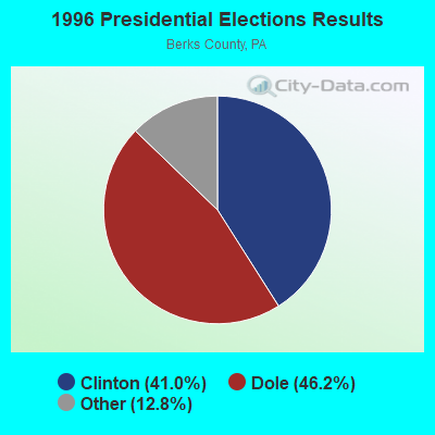
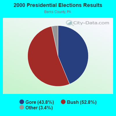

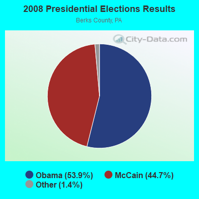
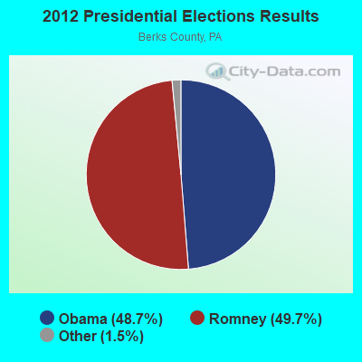
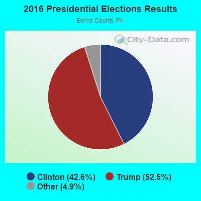
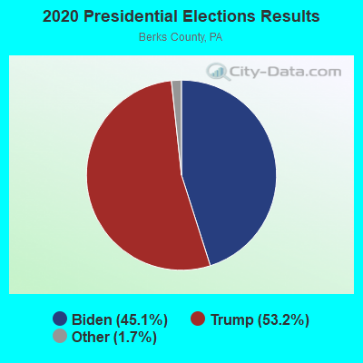
Graphs represent county-level data. Detailed 2008 Election Results
Religion statistics for Lenhartsville, PA (based on Berks County data)
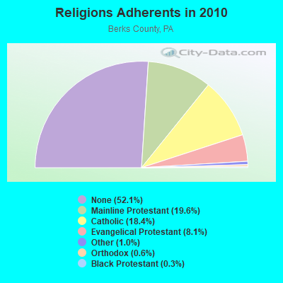
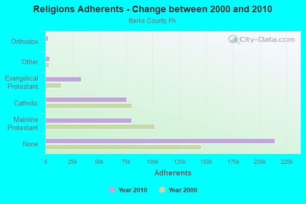
| Religion | Adherents | Congregations |
|---|---|---|
| Mainline Protestant | 80,575 | 177 |
| Catholic | 75,672 | 22 |
| Evangelical Protestant | 33,376 | 168 |
| Other | 3,996 | 23 |
| Orthodox | 2,275 | 5 |
| Black Protestant | 1,062 | 7 |
| None | 214,486 | - |
Food Environment Statistics:
| This county: | 1.87 / 10,000 pop. |
| Pennsylvania: | 2.04 / 10,000 pop. |
| This county: | 0.10 / 10,000 pop. |
| State: | 0.09 / 10,000 pop. |
| Berks County: | 0.37 / 10,000 pop. |
| Pennsylvania: | 0.88 / 10,000 pop. |
| Here: | 2.86 / 10,000 pop. |
| Pennsylvania: | 2.52 / 10,000 pop. |
| Berks County: | 6.28 / 10,000 pop. |
| Pennsylvania: | 7.12 / 10,000 pop. |
| Berks County: | 7.4% |
| Pennsylvania: | 9.1% |
| Here: | 28.0% |
| Pennsylvania: | 27.2% |
| Berks County: | 13.0% |
| Pennsylvania: | 11.5% |
Health and Nutrition:
| Here: | 49.7% |
| Pennsylvania: | 50.2% |
| This city: | 44.6% |
| Pennsylvania: | 47.1% |
| Lenhartsville: | 28.6 |
| Pennsylvania: | 28.7 |
| This city: | 19.3% |
| Pennsylvania: | 20.8% |
| Lenhartsville: | 7.1% |
| Pennsylvania: | 10.9% |
| This city: | 6.8 |
| State: | 6.8 |
| This city: | 26.9% |
| State: | 34.3% |
| This city: | 57.7% |
| State: | 56.2% |
| This city: | 74.7% |
| State: | 78.3% |
More about Health and Nutrition of Lenhartsville, PA Residents
| Local government employment and payroll (March 2022) | |||||
| Function | Full-time employees | Monthly full-time payroll | Average yearly full-time wage | Part-time employees | Monthly part-time payroll |
|---|---|---|---|---|---|
| Financial Administration | 0 | $0 | 1 | $162 | |
| Other Government Administration | 0 | $0 | 9 | $6,467 | |
| Totals for Government | 0 | $0 | 10 | $6,629 | |
Lenhartsville government finances - Expenditure in 2017 (per resident):
- Current Operations - Sewerage: $49,000 ($275.28)
Central Staff Services: $20,000 ($112.36)
Solid Waste Management: $11,000 ($61.80)
General - Other: $7,000 ($39.33)
Regular Highways: $6,000 ($33.71)
Protective Inspection and Regulation - Other: $1,000 ($5.62)
Local Fire Protection: $1,000 ($5.62)
- General - Interest on Debt: $17,000 ($95.51)
Lenhartsville government finances - Revenue in 2017 (per resident):
- Charges - Sewerage: $75,000 ($421.35)
- State Intergovernmental - Other: $6,000 ($33.71)
- Tax - Individual Income: $25,000 ($140.45)
Property: $8,000 ($44.94)
Public Utility License: $2,000 ($11.24)
Documentary and Stock Transfer: $2,000 ($11.24)
Lenhartsville government finances - Debt in 2017 (per resident):
- Long Term Debt - Beginning Outstanding - Unspecified Public Purpose: $416,000 ($2337.08)
Outstanding Unspecified Public Purpose: $397,000 ($2230.34)
Retired Unspecified Public Purpose: $19,000 ($106.74)
Lenhartsville government finances - Cash and Securities in 2017 (per resident):
- Other Funds - Cash and Securities: $175,000 ($983.15)
4.47% of this county's 2021 resident taxpayers lived in other counties in 2020 ($58,739 average adjusted gross income)
| Here: | 4.47% |
| Pennsylvania average: | 5.27% |
0.02% of residents moved from foreign countries ($86 average AGI)
Berks County: 0.02% Pennsylvania average: 0.01%
Top counties from which taxpayers relocated into this county between 2020 and 2021:
| from Montgomery County, PA | |
| from Lehigh County, PA | |
| from Lancaster County, PA |
4.50% of this county's 2020 resident taxpayers moved to other counties in 2021 ($60,184 average adjusted gross income)
| Here: | 4.50% |
| Pennsylvania average: | 5.44% |
0.02% of residents moved to foreign countries ($95 average AGI)
Berks County: 0.02% Pennsylvania average: 0.01%
Top counties to which taxpayers relocated from this county between 2020 and 2021:
| to Montgomery County, PA | |
| to Lancaster County, PA | |
| to Chester County, PA |
Strongest AM radio stations in Lenhartsville:
- WEEU (830 AM; 20 kW; READING, PA; Owner: WEEU BROADCASTING COMPANY)
- WWJZ (640 AM; 50 kW; MOUNT HOLLY, NJ; Owner: ABC, INC.)
- WZZD (990 AM; 50 kW; PHILADELPHIA, PA; Owner: PENNSYLVANIA MEDIA ASSOCIATES, INC.)
- WVCH (740 AM; 50 kW; CHESTER, PA; Owner: WVCH COMMUNICATIONS, INC.)
- KYW (1060 AM; 50 kW; PHILADELPHIA, PA; Owner: INFINITY BROADCASTING OPERATIONS, INC.)
- WPEN (950 AM; 50 kW; PHILADELPHIA, PA; Owner: GREATER PHILADELPHIA RADIO, INC.)
- WNWR (1540 AM; 50 kW; PHILADELPHIA, PA)
- WPPA (1360 AM; 5 kW; POTTSVILLE, PA; Owner: POTTSVILLE BROADCASTING CO.)
- WPHT (1210 AM; 50 kW; PHILADELPHIA, PA; Owner: INFINITY BROADCASTING OPERATIONS, INC.)
- WAEB (790 AM; 4 kW; ALLENTOWN, PA; Owner: CAPSTAR TX LIMITED PARTNERSHIP)
- WLSH (1410 AM; 5 kW; LANSFORD, PA; Owner: J-SYSTEMS FRANCHISING CORP.)
- WMCA (570 AM; 50 kW; NEW YORK, NY; Owner: SALEM MEDIA OF NEW YORK, LLC)
- WYNS (1160 AM; 4 kW; LEHIGHTON, PA; Owner: NASSAU BROADCASTING HOLDINGS, INC.)
Strongest FM radio stations in Lenhartsville:
- W290AC (105.9 FM; PALMERTON, PA; Owner: FAMILY STATIONS, INC.)
- WRFY-FM (102.5 FM; READING, PA; Owner: CLEAR CHANNEL BROADCASTING LICENSES, INC.)
- WLEV (100.7 FM; ALLENTOWN, PA; Owner: CITADEL BROADCASTING COMPANY)
- WRTL (90.7 FM; EPHRATA, PA; Owner: TEMPLE UNIV OF COMMONWEALTH SYSTEM)
- WDIY (88.1 FM; ALLENTOWN, PA; Owner: LEHIGH VALLEY COMMUNITY BR/CST ASSOC)
- WIOV-FM1 (105.1 FM; READING, PA; Owner: REGENT BROADCASTING OF LANCASTER, INC.)
- W220BE (91.9 FM; ST. CLAIR, PA; Owner: SALT & LIGHT MEDIA MINISTRIES, INC.)
- WJCS (89.3 FM; ALLENTOWN, PA; Owner: BEACON BROADCASTING CORPORATION)
- WBSX (97.9 FM; HAZLETON, PA; Owner: CITADEL BROADCASTING COMPANY)
- WMGH-FM (105.5 FM; TAMAQUA, PA; Owner: J-SYSTEMS FRANCHISING CORP.)
- WIOV-FM (105.1 FM; EPHRATA, PA; Owner: REGENT BROADCASTING OF LANCASTER, INC.)
- WAEB-FM (104.1 FM; ALLENTOWN, PA; Owner: CAPSTAR TX LIMITED PARTNERSHIP)
- WBYN (107.5 FM; BOYERTOWN, PA; Owner: WDAC RADIO COMPANY)
- W278AI (103.5 FM; CENTER VALLEY, PA; Owner: BUX-MONT EDUCATIONAL RADIO ASSOCIATION)
- WMGS (92.9 FM; WILKES-BARRE, PA; Owner: CITADEL BROADCASTING COMPANY)
- WVIA-FM (89.9 FM; SCRANTON, PA; Owner: NORTHEASTERN PENNSYLVANIA EDUCATIONAL TV ASSN.)
- WWPJ (89.5 FM; PEN ARGYL, PA; Owner: MERCER COUNTY COMMUNITY COLLEGE)
- W224AU (92.7 FM; ALLENTOWN, PA; Owner: MERCER COUNTY COMMUNITY COLLEGE)
- WFYY (106.5 FM; BLOOMSBURG, PA; Owner: RADIO FRIENDZ, INC.)
- W246AA (97.1 FM; ALLENTOWN, ETC., PA; Owner: TEMPLE UNIV. OF THE COMMONWEALTH,ETC)
TV broadcast stations around Lenhartsville:
- WTVE (Channel 51; READING, PA; Owner: READING BROADCASTING, INC.)
- WFMZ-TV (Channel 69; ALLENTOWN, PA; Owner: MARANATHA BROADCASTING COMPANY, INC.)
- WLYH-TV (Channel 15; LANCASTER, PA; Owner: TELEVISION STATION GROUP LICENSE SUBSIDIARY, LLC)
- WLVT-TV (Channel 39; ALLENTOWN, PA; Owner: LEHIGH VALLEY PUBLIC TELECOMMUNICATIONS CORP.)
- WPHL-TV (Channel 17; PHILADELPHIA, PA; Owner: TRIBUNE TELEVISION COMPANY)
- WBPH-TV (Channel 60; BETHLEHEM, PA; Owner: SONSHINE FAMILY TELEVISION CORPORATION)
- W07DC (Channel 7; ALLENTOWN/BETHLEHEM, PA; Owner: NEW YORK TIMES MANAGEMENT SERVICES)
- WPPX (Channel 61; WILMINGTON, DE; Owner: PAXSON PHILADELPHIA LICENSE, INC.)
- WPVI-TV (Channel 6; PHILADELPHIA, PA; Owner: ABC, INC.)
- National Bridge Inventory (NBI) Statistics
- 17Number of bridges
- 177ft / 53.6mTotal length
- $1,792,000Total costs
- 269,317Total average daily traffic
- 87,956Total average daily truck traffic
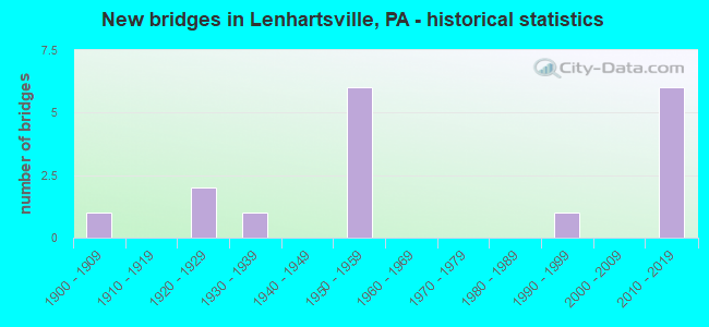
- New bridges - historical statistics
- 11900-1909
- 21920-1929
- 11930-1939
- 61950-1959
- 11990-1999
- 62010-2019
FCC Registered Antenna Towers:
25 (See the full list of FCC Registered Antenna Towers in Lenhartsville)FCC Registered Broadcast Land Mobile Towers:
1- I-78 At Mile Marker 40 (Lat: 40.577222 Lon: -75.799361), Type: Pole, Structure height: 0 m, Overall height: 15 m, Call Sign: WQKP521,
Assigned Frequencies: 1.63000 MHz, Grant Date: 05/23/2019, Expiration Date: 08/03/2029, Certifier: Michael Summerville, Registrant: Pennsylvania Department Of Transportation, 17th And Arsenal, Harrisburg, PA 17102, Phone: (717) 712-3580, Fax: (717) 783-4438, Email:
FCC Registered Microwave Towers:
3- LENHARTSVILLE, Rural Route 3 Box 3359r (Lat: 40.576139 Lon: -75.926167), Type: Tower, Structure height: 54.9 m, Overall height: 56.4 m, Call Sign: WMS886,
Assigned Frequencies: 6197.24 MHz, Grant Date: 03/08/2011, Expiration Date: 02/01/2021, Cancellation Date: 11/28/2016, Certifier: Carol L Tacker, Registrant: At&t Mobility LLC, 1120 20th Street, Nw - Suite 1000, Washington, DC 20036, Phone: (202) 457-2055, Fax: (202) 457-3073, Email:
- EPA0534, 90 Penn St (006672) (Lat: 40.572278 Lon: -75.894389), Type: Ltower, Structure height: 55.4 m, Overall height: 56.6 m, Call Sign: WQTA385,
Assigned Frequencies: 10735.0 MHz, 10935.0 MHz, 10735.0 MHz, 10935.0 MHz, 10735.0 MHz, 10935.0 MHz, 10735.0 MHz, 10935.0 MHz, 10735.0 MHz, 10935.0 MHz... (+10 more), Grant Date: 12/18/2013, Expiration Date: 12/18/2023, Cancellation Date: 07/10/2020, Certifier: Karl Kuykendall, Registrant: Uniti Fiber LLC, 107 St. Francis Street, Suite 1800, Mobile, AL 36602, Phone: (877) 652-2321, Email:
- LENHARTSVILLE, 90 Penn St (006672) (Lat: 40.572278 Lon: -75.894389), Type: Ltower, Structure height: 55.4 m, Overall height: 56.6 m, Call Sign: WQXR891,
Assigned Frequencies: 11055.0 MHz, 11095.0 MHz, 11055.0 MHz, 11095.0 MHz, 11055.0 MHz, 11095.0 MHz, 11055.0 MHz, 11095.0 MHz, 11055.0 MHz, 11095.0 MHz... (+6 more), Grant Date: 05/20/2016, Expiration Date: 05/20/2026, Cancellation Date: 11/14/2017, Certifier: Amir Rajwany, Registrant: Wilkinson Barker Knauer, LLP, 1800 M Street, Nw, Suite 800n, Washington, DC 20036, Phone: (202) 783-4141, Fax: (202) 783-5851, Email:
FCC Registered Amateur Radio Licenses:
10 (See the full list of FCC Registered Amateur Radio Licenses in Lenhartsville)FAA Registered Aircraft:
1- Aircraft: BRM AERO BRISTELL S-LSA (Category: Land, Seats: 2, Weight: Up to 12,499 Pounds), Engine: ROTAX 912ULS SERIES (100 HP) (4 Cycle)
N-Number: 288PT, N288PT, N-288PT, Serial Number: 022/2012, Year manufactured: 2012, Airworthiness Date: 04/13/2012, Certificate Issue Date: 07/28/2017
Registrant (Co-Owned): Terry L Endy, 2195 Old 22, Lenhartsville, PA 19534, Other Owners: Luann K Endy
2004 - 2018 National Fire Incident Reporting System (NFIRS) incidents
- Fire incident types reported to NFIRS in Lenhartsville, PA
- 4943.0%Mobile Property/Vehicle Fires
- 2925.4%Structure Fires
- 2824.6%Outside Fires
- 87.0%Other
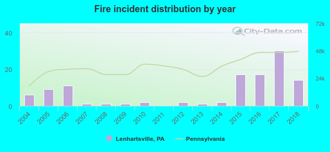 According to the data from the years 2004 - 2018 the average number of fire incidents per year is 8. The highest number of reported fire incidents - 30 took place in 2017, and the least - 0 in 2011. The data has an increasing trend.
 When looking into fire subcategories, the most incidents belonged to: Mobile Property/Vehicle Fires (43.0%), and Structure Fires (25.4%).
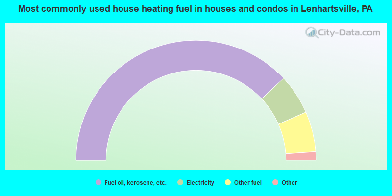
- 77.8%Fuel oil, kerosene, etc.
- 11.1%Electricity
- 11.1%Other fuel
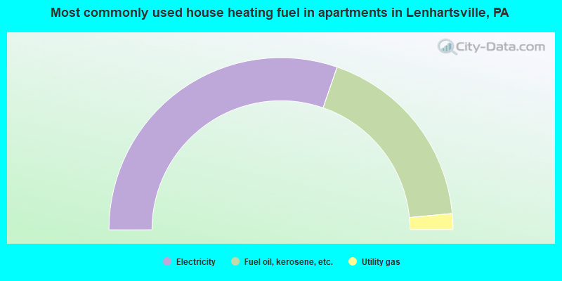
- 60.6%Electricity
- 36.4%Fuel oil, kerosene, etc.
- 3.0%Utility gas
Lenhartsville compared to Pennsylvania state average:
- Unemployed percentage below state average.
- Black race population percentage significantly below state average.
- Hispanic race population percentage significantly below state average.
- Foreign-born population percentage significantly below state average.
- Length of stay since moving in below state average.
- House age above state average.

|
|
Total of 9 patent applications in 2008-2024.