Langell, Oregon
Submit your own pictures of this place and show them to the world
- OSM Map
- General Map
- Google Map
- MSN Map

| Males: 810 | |
| Females: 764 |
| Median resident age: | 43.8 years |
| Oregon median age: | 36.3 years |
| Langell: | $47,421 |
| OR: | $75,657 |
Estimated per capita income in 2022: $30,076 (it was $15,141 in 2000)
Langell CCD income, earnings, and wages data
Estimated median house or condo value in 2022: $257,133 (it was $84,100 in 2000)
| Langell: | $257,133 |
| OR: | $475,600 |
Mean prices in 2022: all housing units: $286,996; detached houses: $312,975; townhouses or other attached units: $346,878; in 2-unit structures: $194,997; in 3-to-4-unit structures: $278,241; in 5-or-more-unit structures: $239,640; mobile homes: $149,678; occupied boats, rvs, vans, etc.: $27,202
Detailed information about poverty and poor residents in Langell, OR


- 1,34689.1%White alone
- 865.7%Hispanic
- 372.4%Two or more races
- 251.7%American Indian alone
- 70.5%Black alone
- 50.3%Asian alone
- 40.3%Native Hawaiian and Other
Pacific Islander alone - 10.07%Other race alone

Races in Langell detailed stats: ancestries, foreign born residents, place of birth
 Recent articles from our blog. Our writers, many of them Ph.D. graduates or candidates, create easy-to-read articles on a wide variety of topics.
Current Local Time: PST time zone
Land area: 982.8 square miles.
Population density: 1.6 people per square mile (very low).

| Langell CCD: | 0.6% ($478) |
| Oregon: | 1.2% ($1,687) |
Nearest city with pop. 50,000+: Medford, OR  (90.5 miles , pop. 63,154).
Nearest city with pop. 200,000+: Northwest Clackamas, OR (224.3 miles , pop. 224,220).
Nearest city with pop. 1,000,000+: Los Angeles, CA (590.0 miles , pop. 3,694,820).
Nearest cities:
), ), )Latitude: 42.35 N, Longitude: 121.09 W
Area code commonly used in this area: 541


| Here: | 5.6% |
| Oregon: | 3.9% |

- Agriculture, forestry, fishing & hunting (27.8%)
- Educational services (9.2%)
- Health care (8.3%)
- Wood products (6.8%)
- Public administration (5.7%)
- Truck transportation (5.0%)
- Accommodation & food services (4.4%)

- Agriculture, forestry, fishing & hunting (48.2%)
- Public administration (8.3%)
- Wood products (7.5%)
- Truck transportation (7.1%)
- Educational services (5.5%)
- Motor vehicle & parts dealers (3.6%)
- Health care (3.6%)

- Educational services (12.4%)
- Health care (12.4%)
- Agriculture, forestry, fishing & hunting (10.0%)
- Accommodation & food services (8.3%)
- Private households (7.9%)
- Social assistance (7.2%)
- Department & other general merchandise stores (6.9%)

- Farmers and farm managers (18.6%)
- Cooks and food preparation workers (6.3%)
- Retail sales workers, except cashiers (6.3%)
- Driver/sales workers and truck drivers (5.0%)
- Other teachers, instructors, education, training, and library occupations (4.8%)
- Agricultural workers, including supervisors (4.6%)
- Supervisors and other personal care and service workers, except child care workers (4.4%)

- Farmers and farm managers (32.8%)
- Life and physical scientists (8.7%)
- Agricultural workers, including supervisors (8.3%)
- Driver/sales workers and truck drivers (7.1%)
- Retail sales workers, except cashiers (6.3%)
- Other material moving workers, except laborers (5.1%)
- Vehicle and mobile equipment mechanics, installers, and repairers (5.1%)

- Cooks and food preparation workers (11.7%)
- Supervisors and other personal care and service workers, except child care workers (8.3%)
- Operations specialties managers, except financial managers (6.9%)
- Other teachers, instructors, education, training, and library occupations (6.6%)
- Nursing, psychiatric, and home health aides (6.6%)
- Farmers and farm managers (6.2%)
- Retail sales workers, except cashiers (6.2%)
Average climate in Langell, Oregon
Based on data reported by over 4,000 weather stations


Earthquake activity:
Langell-area historical earthquake activity is significantly above Oregon state average. It is 3577% greater than the overall U.S. average.On 10/3/1915 at 06:52:48, a magnitude 7.6 (7.6 UK, Class: Major, Intensity: VIII - XII) earthquake occurred 225.8 miles away from the city center
On 4/18/1906 at 13:12:21, a magnitude 7.9 (7.9 UK) earthquake occurred 317.1 miles away from Langell center, causing $524,000,000 total damage
On 1/31/1922 at 13:17:28, a magnitude 7.6 (7.6 UK) earthquake occurred 257.6 miles away from the city center
On 11/8/1980 at 10:27:34, a magnitude 7.2 (6.2 MB, 7.2 MS, 7.2 MW, 7.0 ML) earthquake occurred 186.4 miles away from the city center
On 4/25/1992 at 18:06:04, a magnitude 7.2 (6.3 MB, 7.1 MS, 7.2 MW, 7.1 MW, Depth: 9.4 mi) earthquake occurred 207.3 miles away from the city center, causing $75,000,000 total damage
On 1/22/1923 at 09:04:18, a magnitude 7.2 (7.2 UK) earthquake occurred 254.4 miles away from Langell center
Magnitude types: body-wave magnitude (MB), local magnitude (ML), surface-wave magnitude (MS), moment magnitude (MW)
Natural disasters:
The number of natural disasters in Klamath County (8) is smaller than the US average (15).Major Disasters (Presidential) Declared: 4
Emergencies Declared: 2
Causes of natural disasters: Fires: 2, Floods: 2, Drought: 1, Earthquake: 1, Heavy Rain: 1, Hurricane: 1, Wind: 1, Winter Storm: 1, Other: 1 (Note: some incidents may be assigned to more than one category).
Colleges/universities with over 2000 students nearest to Langell:
- Oregon Institute of Technology (about 37 miles; Klamath Falls, OR; Full-time enrollment: 2,900)
- Southern Oregon University (about 83 miles; Ashland, OR; FT enrollment: 4,650)
- Rogue Community College (about 118 miles; Grants Pass, OR; FT enrollment: 3,600)
- Central Oregon Community College (about 120 miles; Bend, OR; FT enrollment: 5,217)
- Shasta College (about 135 miles; Redding, CA; FT enrollment: 5,645)
- Lane Community College (about 152 miles; Eugene, OR; FT enrollment: 6,373)
- University of Oregon (about 155 miles; Eugene, OR; FT enrollment: 23,329)
Public high school in Langell:
- JOHN F KENNEDY HIGH SCHOOL (Students: 248, Location: 890 E MARQUAM ST, Grades: 9-12)
Public elementary/middle schools in Langell:
- ST MARYS PUBLIC SCHOOL (Students: 341, Location: 590 E COLLEGE, Grades: KG-5)
- BUTTE CREEK ELEMENTARY SCHOOL (Students: 284, Location: 37569 S HWY 213, Grades: KG-8)
- MT ANGEL MIDDLE SCHOOL (Students: 204, Location: 460 E MARQUAM ST, Grades: 6-8)
Points of interest:
Notable locations in Langell: McCartie Ranch (A), Ivory Pine Mill (B), Mud Spring Camp (C), Kitts Mill (D), Keno Springs Ranch (E), Keno Guard Station (F), Camp Six Guard Station (G), Johnson Ranch (H), Irwins Pump (I), Fishhole Substation (J), Lee Adkins Place (K), Obenchain Ranch (L), BK Ranch (M), Campbell Ranch (N), North Fork Ranch (O), Hunt Ranch (P), Griffin Ranch (Q), B K Ranch (R), Glover Ranch (S), Gerber Ranch (T). Display/hide their locations on the map
Cemeteries: Bedfield Cemetery (1), Bonanza Memorial Park (2), Haynesville Cemetery (3). Display/hide their locations on the map
Lakes, reservoirs, and swamps: Klipple Lake (A), Lost Lake (B), Pankey Lake (C), Pitch Lake (D), Lockey Flat (E), Noble Pond (F), Goodlow Pond (G), Rock Pond (H). Display/hide their locations on the map
Streams, rivers, and creeks: Yaden Creek (A), Gayheart Slough (B), Leonard Slough (C), Modoc Billy Creek (D), Fritz Creek (E), Fishhole Creek (F), Deming Creek (G), Currier Creek (H), Cain Creek (I). Display/hide their locations on the map
Parks in Langell include: Antelope Reservoir Day-Use Area (1), Paddock Camp (2), Klamath Falls-Lakeview Forest State Park (3), Goodlow Mountain Research Natural Area (4). Display/hide their locations on the map
| This place: | 2.6 people |
| Oregon: | 2.5 people |
| This place: | 63.1% |
| Whole state: | 66.3% |
| This place: | 3.6% |
| Whole state: | 6.3% |
Likely homosexual households (counted as self-reported same-sex unmarried-partner households)
- Lesbian couples: 0.2% of all households
- Gay men: 0.0% of all households
| This place: | 19.4% |
| Whole state: | 11.6% |
| This place: | 5.8% |
| Whole state: | 5.0% |
For population 15 years and over in Langell:

- Never married: 12.6%
- Now married: 65.0%
- Separated: 0.0%
- Widowed: 7.3%
- Divorced: 15.1%
For population 25 years and over in Langell:
- High school or higher: 75.4%
- Bachelor's degree or higher: 12.8%
- Graduate or professional degree: 5.0%
- Unemployed: 8.3%
- Mean travel time to work (commute): 21.3 minutes


| Here: | 11.2 |
| Oregon average: | 11.5 |
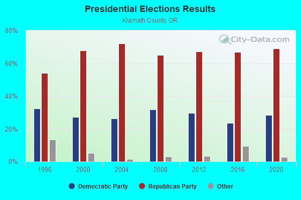
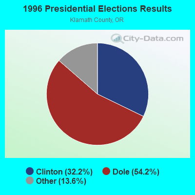
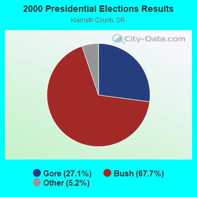
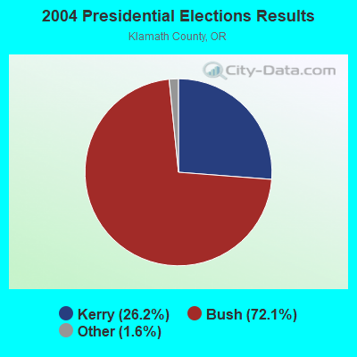
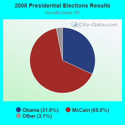
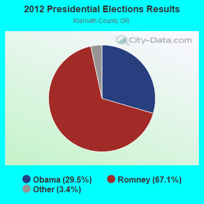
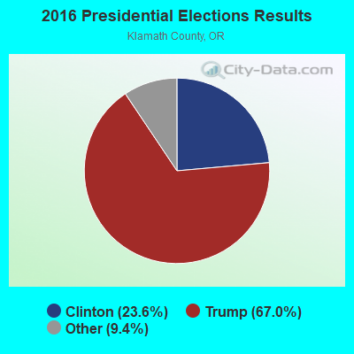
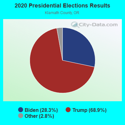
Graphs represent county-level data. Detailed 2008 Election Results
Religion statistics for Langell, OR (based on Klamath County data)
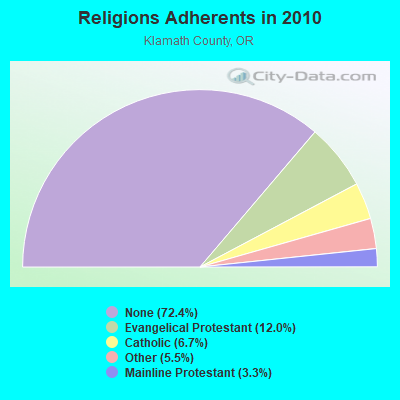
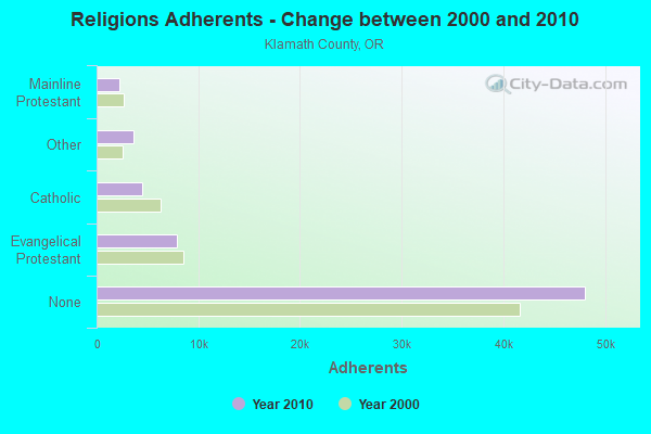
| Religion | Adherents | Congregations |
|---|---|---|
| Evangelical Protestant | 7,945 | 63 |
| Catholic | 4,460 | 7 |
| Other | 3,677 | 14 |
| Mainline Protestant | 2,218 | 14 |
| Black Protestant | 30 | 1 |
| None | 48,050 | - |
Food Environment Statistics:
| This county: | 2.41 / 10,000 pop. |
| State: | 2.03 / 10,000 pop. |
| Klamath County: | 0.30 / 10,000 pop. |
| Oregon: | 0.33 / 10,000 pop. |
| This county: | 1.81 / 10,000 pop. |
| Oregon: | 2.01 / 10,000 pop. |
| This county: | 2.71 / 10,000 pop. |
| State: | 1.69 / 10,000 pop. |
| Klamath County: | 8.88 / 10,000 pop. |
| State: | 9.93 / 10,000 pop. |
| This county: | 8.3% |
| Oregon: | 7.4% |
| Here: | 25.0% |
| Oregon: | 25.6% |
| Klamath County: | 12.0% |
| Oregon: | 14.2% |
7.87% of this county's 2021 resident taxpayers lived in other counties in 2020 ($50,573 average adjusted gross income)
| Here: | 7.87% |
| Oregon average: | 8.20% |
0.09% of residents moved from foreign countries ($401 average AGI)
Klamath County: 0.09% Oregon average: 0.01%
Top counties from which taxpayers relocated into this county between 2020 and 2021:
| from Deschutes County, OR | |
| from Jackson County, OR | |
| from Lane County, OR |
Strongest AM radio stations in Langell:
- KKJX (960 AM; 5 kW; KLAMATH FALLS, OR; Owner: NEW NORTHWEST BROADCASTERS, LLC)
- KAGO (1150 AM; 5 kW; KLAMATH FALLS, OR; Owner: NEW NORTHWEST BROADCASTERS, LLC)
- KTMT (580 AM; 10 kW; ASHLAND, OR; Owner: MAPLETON COMMUNICATIONS, LLC)
- KGRV (700 AM; 25 kW; WINSTON, OR; Owner: PACIFIC CASCADE COMMUNICATIONS CORP.)
- KPNW (1120 AM; 50 kW; EUGENE, OR; Owner: CAPSTAR TX LIMITED PARTNERSHIP)
- KAPL (1300 AM; 20 kW; PHOENIX, OR; Owner: APPLEGATE MEDIA, INC.)
- KKOH (780 AM; 50 kW; RENO, NV; Owner: CITADEL BROADCASTING COMPANY)
- KDUN (1030 AM; 50 kW; REEDSPORT, OR; Owner: PAMPLIN BROADCASTING-OREGON, INC.)
- KPOJ (620 AM; 50 kW; PORTLAND, OR; Owner: CITICASTERS LICENSES, L.P.)
- KCFJ (570 AM; 5 kW; ALTURAS, CA; Owner: EDI MEDIA, INC.)
- KXL (750 AM; 50 kW; PORTLAND, OR; Owner: ROSE CITY RADIO CORPORATION)
- KBOI (670 AM; 50 kW; BOISE, ID; Owner: CITADEL BROADCASTING COMPANY)
- KRTA (610 AM; 5 kW; MEDFORD, OR; Owner: OPUS BROADCASTING SYSTEMS, INC.)
Strongest FM radio stations in Langell:
- KKRB (106.9 FM; KLAMATH FALLS, OR; Owner: WYNNE BROADCASTING COMPANY, INC.)
- KYSF (102.9 FM; BONANZA, OR; Owner: NEW NORTHWEST BROADCASTERS, LLC)
- KSKF (90.9 FM; KLAMATH FALLS, OR; Owner: ST OF OREGON ACT BY ST BOARD OF HIGH ED)
- K210BY (89.9 FM; KLAMATH FALLS, OR; Owner: PENSACOLA CHRISTIAN COLLEGE, INC.)
- KLMF (88.5 FM; KLAMATH FALLS, OR; Owner: THE STATE BOARD OF HIGHER EDUCATION)
- KFLS-FM (96.5 FM; TULELAKE, CA; Owner: WYNNE BROADCASTING COMPANY, INC.)
- KLAD-FM (92.5 FM; KLAMATH FALLS, OR; Owner: NEW NORTHWEST BROADCASTERS, LLC)
- KFEG (104.7 FM; KLAMATH FALLS, OR; Owner: COVE ROAD PUBLISHING LLC)
- KKLJ (88.9 FM; KLAMATH FALLS, OR; Owner: EDUCATIONAL MEDIA FOUNDATION)
- KRAT (97.7 FM; ALTAMONT, OR; Owner: GEORGE J. WADE)
- KAGO-FM (99.5 FM; KLAMATH FALLS, OR; Owner: NEW NORTHWEST BROADCASTERS, LLC)
- KQIK-FM (93.5 FM; LAKEVIEW, OR; Owner: CLAUSE CHARITABLE REMAINDER TRUST)
- KLCR (95.3 FM; LAKEVIEW, OR; Owner: WOODROW MICHAEL WARREN)

- 34.6%Wood
- 29.3%Electricity
- 28.0%Fuel oil, kerosene, etc.
- 5.3%Bottled, tank, or LP gas
- 2.4%No fuel used
- 0.4%Other fuel

- 35.4%Fuel oil, kerosene, etc.
- 33.1%Electricity
- 19.7%Wood
- 7.9%Bottled, tank, or LP gas
- 3.9%Utility gas
Langell compared to Oregon state average:
- Median household income below state average.
- Median house value below state average.
- Unemployed percentage below state average.
- Black race population percentage significantly below state average.
- Hispanic race population percentage below state average.
- Median age above state average.
- Foreign-born population percentage significantly below state average.
- Renting percentage significantly below state average.
- Length of stay since moving in significantly above state average.
- Number of rooms per house significantly below state average.
- House age significantly below state average.
- Percentage of population with a bachelor's degree or higher below state average.