Kentucky Ridge, Kentucky
Submit your own pictures of this place and show them to the world
- OSM Map
- General Map
- Google Map
- MSN Map

| Males: 1,122 | |
| Females: 971 |
| Median resident age: | 33.8 years |
| Kentucky median age: | 35.9 years |
Zip code: 40977
| Kentucky Ridge: | $26,517 |
| KY: | $59,341 |
Estimated per capita income in 2022: $11,632 (it was $6,865 in 2000)
Kentucky Ridge CCD income, earnings, and wages data
Estimated median house or condo value in 2022: $70,580 (it was $34,600 in 2000)
| Kentucky Ridge: | $70,580 |
| KY: | $196,300 |
Mean prices in 2022: all housing units: $126,319; detached houses: $148,633; townhouses or other attached units: $90,266; in 2-unit structures: $102,201; in 3-to-4-unit structures: $378,810; mobile homes: $61,459
Kentucky Ridge, KY residents, houses, and apartments details
Detailed information about poverty and poor residents in Kentucky Ridge, KY
Compare current foreclosures near Kentucky Ridge, KY:
| Photo | Address | Area | Beds / Baths | Price | Details |
|---|---|---|---|---|---|

|
#1
John Bailey Rd
Arjay, KY 40902
|
- sq. feet
|
- baths - beds |
$17,900
|
show details |

|
#2
Big Brush Church Creek Rd
Trosper, KY 40995
|
- sq. feet
|
- baths - beds |
$11,900
|
show details |

|
#3
Edgewood Dr
Barbourville, KY 40906
|
2,104 sq. feet
|
3 baths 4 beds |
show details | |

|
#4
N 16th St
Middlesboro, KY 40965
|
672 sq. feet
|
1 baths 2 beds |
show details | |

|
#5
Sandefur Ridge Rd
Harrogate, TN 37752
|
2,639 sq. feet
|
2 baths - beds |
show details | |

|
#6
Kent Rd
Harrogate, TN 37752
|
2,439 sq. feet
|
2 baths - beds |
show details | |

|
#7
Clyde St
Harrogate, TN 37752
|
1,001 sq. feet
|
1 baths - beds |
show details | |

|
#8
Forge Ridge Rd
Harrogate, TN 37752
|
1,215 sq. feet
|
1 baths - beds |
show details | |

|
#9
Providence Rd
Cumberland Gap, TN 37724
|
1,000 sq. feet
|
1 baths - beds |
show details | |

|
#10
Dogwood Trl
Pineville, KY 40977
|
2,255 sq. feet
|
3 baths - beds |
show details |
| Photo | Address | Area | Beds / Baths | Price | Details |
|---|---|---|---|---|---|

|
#11
Valley Ln
Speedwell, TN 37870
|
1,792 sq. feet
|
2 baths - beds |
show details | |

|
#12
Brantley Acres Rd
Speedwell, TN 37870
|
1,836 sq. feet
|
2 baths - beds |
show details | |

|
#13
Back Valley Rd
Speedwell, TN 37870
|
1,008 sq. feet
|
1 baths - beds |
show details | |

|
#14
Russell Hill Rd
Speedwell, TN 37870
|
1,488 sq. feet
|
2 baths - beds |
show details | |

|
#15
Toppy Russell Rd
Speedwell, TN 37870
|
1,404 sq. feet
|
1 baths - beds |
show details | |

|
#16
Opal St
Tazewell, TN 37879
|
936 sq. feet
|
1 baths - beds |
show details | |

|
#17
Summit Dr
Speedwell, TN 37870
|
2,552 sq. feet
|
2 baths - beds |
show details | |

|
#18
Roosevelt St
Harrogate, TN 37752
|
1,040 sq. feet
|
1 baths - beds |
show details | |

|
#19
Williams Branch Right Fork Rd
Pineville, KY 40977
|
1,056 sq. feet
|
1 baths - beds |
show details | |

|
#20
N 28th St
Middlesboro, KY 40965
|
1,113 sq. feet
|
1 baths - beds |
show details |
| Photo | Address | Area | Beds / Baths | Price | Details |
|---|---|---|---|---|---|

|
#21
Benfield Ln # 29
Harrogate, TN 37752
|
- sq. feet
|
- baths - beds |
show details | |

|
#22
Highway 90
Clairfield, TN 37715
|
672 sq. feet
|
- baths - beds |
show details | |

|
#23
Rose Rd
Pineville, KY 40977
|
- sq. feet
|
- baths - beds |
show details | |

|
#24
Progress Rd
Bimble, KY 40915
|
- sq. feet
|
- baths - beds |
show details | |

|
#25
The Meadow Trl
Barbourville, KY 40906
|
- sq. feet
|
- baths - beds |
show details | |

|
#26
Warren Camp Rd
Barbourville, KY 40906
|
- sq. feet
|
- baths - beds |
show details | |

|
#27
Allen Ln
Hulen, KY 40845
|
- sq. feet
|
- baths - beds |
show details | |

|
#28
Shelton Rd
Williamsburg, KY 40769
|
- sq. feet
|
- baths - beds |
show details | |

|
#29
Sampson Ln
Barbourville, KY 40906
|
- sq. feet
|
- baths - beds |
show details | |

|
#30
Catron Ave
Barbourville, KY 40906
|
- sq. feet
|
- baths - beds |
show details |
| Photo | Address | Area | Beds / Baths | Price | Details |
|---|---|---|---|---|---|

|
#31
W Chester Ave Apt 2
Middlesboro, KY 40965
|
- sq. feet
|
- baths - beds |
show details | |

|
#32
Cumberland Ave Apt 2b
Barbourville, KY 40906
|
- sq. feet
|
- baths - beds |
show details | |

|
#33
N Us Highway 25e
Barbourville, KY 40906
|
- sq. feet
|
- baths - beds |
show details | |

|
#34
Rock Creek Ridge Rd
Clairfield, TN 37715
|
- sq. feet
|
- baths - beds |
show details | |

|
#35
Old Pineville Pike
Middlesboro, KY 40965
|
- sq. feet
|
- baths - beds |
show details | |

|
#36
Ky 6
Barbourville, KY 40906
|
- sq. feet
|
- baths - beds |
show details | |

|
#37
Blue Diamond Camp Rd
Pathfork, KY 40863
|
- sq. feet
|
- baths - beds |
show details | |

|
#38
Ky 1304
Hinkle, KY 40953
|
- sq. feet
|
- baths - beds |
show details | |

|
#39
Mcgaffie Loop
Pineville, KY 40977
|
- sq. feet
|
- baths - beds |
show details | |

|
#40
G And A Ln
Hinkle, KY 40953
|
- sq. feet
|
- baths - beds |
show details |
| Photo | Address | Area | Beds / Baths | Price | Details |
|---|---|---|---|---|---|

|
#41
Parsons Ln
Tazewell, TN 37879
|
- sq. feet
|
- baths - beds |
show details | |

|
#42
Highway 1534
Pineville, KY 40977
|
- sq. feet
|
- baths - beds |
show details | |

|
#43
Bull Run Rd
Barbourville, KY 40906
|
- sq. feet
|
- baths - beds |
show details | |

|
#44
Fairview Trl
Bimble, KY 40915
|
- sq. feet
|
- baths - beds |
show details | |

|
#45
Cumberland Ave Apt 1c
Barbourville, KY 40906
|
- sq. feet
|
- baths - beds |
show details | |

|
#46
Washington Ave
Harrogate, TN 37752
|
- sq. feet
|
- baths - beds |
show details | |

|
#47
Westend Homes
Middlesboro, KY 40965
|
- sq. feet
|
- baths - beds |
show details | |

|
#48
Ramsey Branch Rd
Artemus, KY 40903
|
- sq. feet
|
- baths - beds |
show details | |

|
#49
Duncan Ln
Middlesboro, KY 40965
|
- sq. feet
|
- baths - beds |
show details | |

|
Check over 1 million property listings on Foreclosure.com!
|
browse all offers | |||

- 2,06895.4%White alone
- 753.5%Black alone
- 90.4%Two or more races
- 70.3%Asian alone
- 40.2%American Indian alone
- 40.2%Hispanic

Races in Kentucky Ridge detailed stats: ancestries, foreign born residents, place of birth
 Recent articles from our blog. Our writers, many of them Ph.D. graduates or candidates, create easy-to-read articles on a wide variety of topics.
Current Local Time: EST time zone
Land area: 41.7 square miles.
Population density: 50 people per square mile (very low).

| Kentucky Ridge CCD: | 0.9% ($321) |
| Kentucky: | 0.8% ($610) |
Nearest city with pop. 50,000+: Knoxville, TN  (51.8 miles , pop. 173,890).
Nearest city with pop. 200,000+: Fayette, KY (100.3 miles , pop. 260,512).
Nearest city with pop. 1,000,000+: Chicago, IL (412.7 miles , pop. 2,896,016).
Nearest cities:
), ), ), ), )Latitude: 36.71 N, Longitude: 83.75 W
Area code commonly used in this area: 606


| Here: | 5.3% |
| Kentucky: | 3.8% |

- Educational services (21.6%)
- Health care (15.3%)
- Construction (10.6%)
- Mining, quarrying, oil & gas extraction (8.0%)
- Furniture & related product manufacturing (6.9%)
- Public administration (5.3%)
- Accommodation & food services (4.7%)

- Educational services (21.9%)
- Construction (13.2%)
- Mining, quarrying, oil & gas extraction (12.6%)
- Health care (9.4%)
- Furniture & related product manufacturing (7.4%)
- Repair & maintenance (5.2%)
- Agriculture, forestry, fishing & hunting (4.2%)

- Health care (25.6%)
- Educational services (21.1%)
- Accommodation & food services (12.8%)
- Public administration (7.8%)
- Department & other general merchandise stores (6.7%)
- Furniture & related product manufacturing (6.1%)
- Construction (6.1%)

- Vehicle and mobile equipment mechanics, installers, and repairers (8.6%)
- Cooks and food preparation workers (8.0%)
- Laborers and material movers, hand (6.1%)
- Other teachers, instructors, education, training, and library occupations (5.9%)
- Metal workers and plastic workers (5.9%)
- Information and record clerks, except customer service representatives (4.7%)
- Registered nurses (4.7%)

- Vehicle and mobile equipment mechanics, installers, and repairers (13.5%)
- Metal workers and plastic workers (9.4%)
- Cooks and food preparation workers (7.7%)
- Laborers and material movers, hand (6.1%)
- Construction traders workers except carpenters, electricians, painters, plumbers, and construction laborers (5.5%)
- Extraction workers (4.8%)
- Postsecondary teachers (4.2%)

- Registered nurses (12.8%)
- Information and record clerks, except customer service representatives (12.8%)
- Other teachers, instructors, education, training, and library occupations (11.7%)
- Secretaries and administrative assistants (9.4%)
- Cooks and food preparation workers (8.3%)
- Nursing, psychiatric, and home health aides (7.2%)
- Cashiers (6.7%)
Average climate in Kentucky Ridge, Kentucky
Based on data reported by over 4,000 weather stations


(lower is better)

Air Quality Index (AQI) level in 2023 was 80.8. This is about average.
| City: | 80.8 |
| U.S.: | 72.6 |

Carbon Monoxide (CO) [ppm] level in 2000 was 0.127. This is significantly better than average. Closest monitor was 6.8 miles away from the city center.
| City: | 0.127 |
| U.S.: | 0.251 |

Ozone [ppb] level in 2023 was 30.8. This is about average. Closest monitor was 6.8 miles away from the city center.
| City: | 30.8 |
| U.S.: | 33.3 |

Particulate Matter (PM2.5) [µg/m3] level in 2022 was 9.68. This is about average. Closest monitor was 6.8 miles away from the city center.
| City: | 9.68 |
| U.S.: | 8.11 |
Tornado activity:
Kentucky Ridge-area historical tornado activity is significantly below Kentucky state average. It is 39% smaller than the overall U.S. average.
On 5/9/1988, a category F3 (max. wind speeds 158-206 mph) tornado 7.3 miles away from the Kentucky Ridge place center killed one person and injured 15 people and caused between $5,000,000 and $50,000,000 in damages.
On 3/12/1967, a category F3 tornado 20.6 miles away from the place center .
Earthquake activity:
Kentucky Ridge-area historical earthquake activity is significantly above Kentucky state average. It is 66% greater than the overall U.S. average.On 7/27/1980 at 18:52:21, a magnitude 5.2 (5.1 MB, 4.7 MS, 5.0 UK, 5.2 UK, Class: Moderate, Intensity: VI - VII) earthquake occurred 104.2 miles away from the city center
On 8/9/2020 at 12:07:37, a magnitude 5.1 (5.1 MW, Depth: 4.7 mi) earthquake occurred 148.4 miles away from the city center
On 11/30/1973 at 07:48:41, a magnitude 4.7 (4.7 MB, 4.6 ML, Class: Light, Intensity: IV - V) earthquake occurred 63.8 miles away from Kentucky Ridge center
On 8/23/2011 at 17:51:04, a magnitude 5.8 (5.8 MW, Depth: 3.7 mi) earthquake occurred 330.5 miles away from Kentucky Ridge center
On 4/18/2008 at 09:36:59, a magnitude 5.4 (5.1 MB, 4.8 MS, 5.4 MW, 5.2 MW) earthquake occurred 256.8 miles away from the city center
On 9/7/1988 at 02:28:09, a magnitude 4.6 (4.5 MB, 4.6 LG) earthquake occurred 99.7 miles away from Kentucky Ridge center
Magnitude types: regional Lg-wave magnitude (LG), body-wave magnitude (MB), local magnitude (ML), surface-wave magnitude (MS), moment magnitude (MW)
Natural disasters:
The number of natural disasters in Bell County (21) is greater than the US average (15).Major Disasters (Presidential) Declared: 14
Emergencies Declared: 2
Causes of natural disasters: Floods: 14, Storms: 12, Mudslides: 5, Landslides: 4, Tornadoes: 4, Fires: 2, Snows: 2, Winds: 2, Winter Storms: 2, Blizzard: 1, Freeze: 1, Hurricane: 1, Snowfall: 1, Snowstorm: 1, Other: 1 (Note: some incidents may be assigned to more than one category).
Hospitals and medical centers near Kentucky Ridge:
- PINEVILLE COMMUNITY HOSPITAL Acute Care Hospitals (about 5 miles away; PINEVILLE, KY)
- MIDDLESBORO HEALTH CARE FACILITY (Nursing Home, about 7 miles away; MIDDLESBORO, KY)
- MIDDLESBORO APPALACHIAN REGIONAL HEALTHCARE HOSPIT Acute Care Hospitals (about 7 miles away; MIDDLESBORO, KY)
- MIDDLESBORO ARH HOME HEALTH AGENCY (Home Health Center, about 8 miles away; MIDDLESBORO, KY)
- AMEDISYS HOME HEALTH CARE (Home Health Center, about 8 miles away; MIDDLESBORO, KY)
- TRI STATE HEALTH AND REHABILITATION CENTER (Nursing Home, about 11 miles away; HARROGATE, TN)
- BARBOURVILLE HEALTH AND REHABILITATION CENTER (Nursing Home, about 15 miles away; BARBOURVILLE, KY)
Colleges/universities with over 2000 students nearest to Kentucky Ridge:
- Lincoln Memorial University (about 11 miles; Harrogate, TN; Full-time enrollment: 3,706)
- University of the Cumberlands (about 23 miles; Williamsburg, KY; FT enrollment: 3,585)
- Walters State Community College (about 44 miles; Morristown, TN; FT enrollment: 4,359)
- Southeast Kentucky Community and Technical College (about 46 miles; Cumberland, KY; FT enrollment: 2,196)
- Hazard Community and Technical College (about 49 miles; Hazard, KY; FT enrollment: 2,087)
- The University of Tennessee-Knoxville (about 53 miles; Knoxville, TN; FT enrollment: 25,483)
- Somerset Community College (about 54 miles; Somerset, KY; FT enrollment: 4,698)
Points of interest:
Notable locations in Kentucky Ridge: Hemlock Garden Picnic Area (A), Pine Mountain Lodge (B), Bell County Volunteer Fire Department Clear Creek Station (C). Display/hide their locations on the map
Churches in Kentucky Ridge include: Fuson Chapel (A), Harmony Church (B), Salem Church (C), Salem Number 2 Church (D). Display/hide their locations on the map
Cemeteries: Mason Cemetery (1), Bratcher Cemetery (2), Peavier Cemetery (3), Head Cemetery (4), Lee Cemetery (5), Knuckle Cemetery (6), Shelton Cemetery (7). Display/hide their locations on the map
Reservoirs: Cannon Creek Lake (A), Pine Mountain Lake (B). Display/hide their locations on the map
Streams, rivers, and creeks: Bear Creek (A), Becky Branch (B), Bens Fork (C), Bratcher Branch (D), Brooks Branch (E), Phoebe Branch (F), Webb Branch (G), Water Tank Branch (H), Collins Branch (I). Display/hide their locations on the map
Park in Kentucky Ridge: Pine Mountain State Resort Park (1). Display/hide its location on the map
| This place: | 2.3 people |
| Kentucky: | 2.5 people |
| This place: | 66.9% |
| Whole state: | 66.9% |
| This place: | 3.7% |
| Whole state: | 6.4% |
Likely homosexual households (counted as self-reported same-sex unmarried-partner households)
- Lesbian couples: 0.5% of all households
- Gay men: 0.5% of all households
| This place: | 35.1% |
| Whole state: | 15.8% |
| This place: | 20.2% |
| Whole state: | 6.6% |
People in group quarters in Kentucky Ridge in 2010:
- 298 people in correctional residential facilities
- 288 people in college/university student housing
- 79 people in nursing facilities/skilled-nursing facilities
People in group quarters in Kentucky Ridge in 2000:
- 225 people in state prisons
- 96 people in nursing homes
- 66 people in college dormitories (includes college quarters off campus)
For population 15 years and over in Kentucky Ridge:

- Never married: 18.2%
- Now married: 67.8%
- Separated: 2.4%
- Widowed: 5.5%
- Divorced: 8.5%
For population 25 years and over in Kentucky Ridge:
- High school or higher: 58.1%
- Bachelor's degree or higher: 6.2%
- Graduate or professional degree: 2.6%
- Unemployed: 14.5%
- Mean travel time to work (commute): 24.5 minutes


| Here: | 16.0 |
| Kentucky average: | 13.8 |
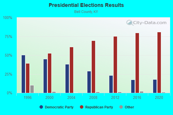
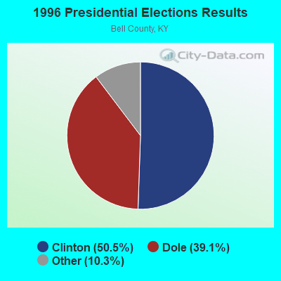
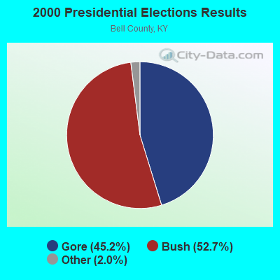

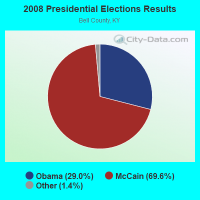
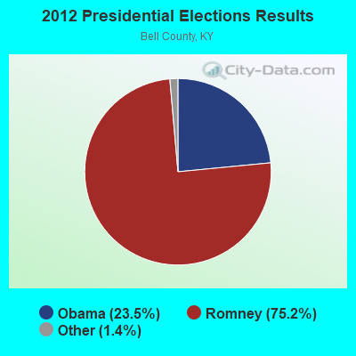
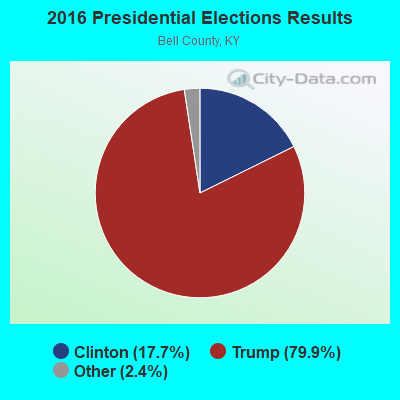
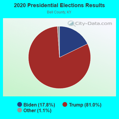
Graphs represent county-level data. Detailed 2008 Election Results
Religion statistics for Kentucky Ridge, KY (based on Bell County data)
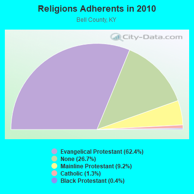
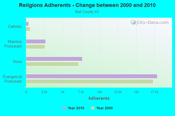
| Religion | Adherents | Congregations |
|---|---|---|
| Evangelical Protestant | 17,897 | 64 |
| Mainline Protestant | 2,651 | 12 |
| Catholic | 372 | 2 |
| Black Protestant | 119 | 1 |
| Other | 2 | - |
| None | 7,650 | - |
Food Environment Statistics:
| Bell County: | 4.14 / 10,000 pop. |
| Kentucky: | 2.19 / 10,000 pop. |
| Bell County: | 0.34 / 10,000 pop. |
| Kentucky: | 0.25 / 10,000 pop. |
| Here: | 2.41 / 10,000 pop. |
| Kentucky: | 4.36 / 10,000 pop. |
| Here: | 3.45 / 10,000 pop. |
| Kentucky: | 5.74 / 10,000 pop. |
| Bell County: | 13.5% |
| State: | 11.0% |
| Bell County: | 34.2% |
| Kentucky: | 30.0% |
| Here: | 19.4% |
| Kentucky: | 15.9% |
Strongest AM radio stations in Kentucky Ridge:
- WMIK (560 AM; 2 kW; MIDDLESBORO, KY; Owner: GATEWAY BROADCASTING, INC.)
- WANO (1230 AM; 1 kW; PINEVILLE, KY; Owner: CUMBERLAND MEDIA GROUP, INC.)
- WKVL (850 AM; daytime; 50 kW; KNOXVILLE, TN; Owner: HORNE RADIO, LLC)
- WFXY (1490 AM; 1 kW; MIDDLESBORO, KY; Owner: COUNTRY WIDE BROADCASTERS, INC.)
- WRWB (740 AM; 1 kW; HARROGATE, TN; Owner: PINE HILLS OF TENNESSEE, INC.)
- WEKC (710 AM; daytime; 4 kW; WILLIAMSBURG, KY; Owner: GERALD PARKS)
- WYWY (950 AM; 1 kW; BARBOURVILLE, KY; Owner: BARBOURVILLE-COMMNITY BROADC/G CO IN)
- WFSR (970 AM; 5 kW; HARLAN, KY; Owner: EASTERN BROADCASTING COMPAY)
- WHLN (1410 AM; 5 kW; HARLAN, KY)
- WKDP (1330 AM; 5 kW; CORBIN, KY; Owner: EUBANKS BROADCASTING, INC.)
- WNOX (990 AM; 10 kW; KNOXVILLE, TN)
- WKLB (1290 AM; 5 kW; MANCHESTER, KY; Owner: BARKER BROADCASTING COMPANY, INC.)
- WFGW (1010 AM; 50 kW; BLACK MOUNTAIN, NC; Owner: BLUE RIDGE BROADCASTING CORP.)
Strongest FM radio stations in Kentucky Ridge:
- WRIL (106.3 FM; PINEVILLE, KY; Owner: PINE HILLS BROADCASTING, INC.)
- WMIK-FM (92.7 FM; MIDDLESBORO, KY; Owner: GATEWAY BROADCASTING, INC.)
- WCTU (105.9 FM; TAZEWELL, TN; Owner: STAIR COMPANY, INC)
- WLMU (91.3 FM; HARROGATE, TN; Owner: LINCOLN MEMORIAL UNIVERSITY)
- WEKX (102.7 FM; JELLICO, TN; Owner: WHITLEY BROADCASTING CO., INC.)
- WIMZ-FM (103.5 FM; KNOXVILLE, TN; Owner: SOUTH CENTRAL COMM., CORP.)
- WDVX (89.9 FM; CLINTON, TN; Owner: CUMBERLAND COMMUNITIES COMMUNI CORP.)
- WKDP-FM (99.5 FM; CORBIN, KY; Owner: EUBANKS BROADCASTING, INC.)
- WTUK (105.1 FM; HARLAN, KY; Owner: EASTERN BROADCASTING COMPANY)
- WSEH (102.7 FM; CUMBERLAND, KY; Owner: CUMBERLAND CITY BROADCASTING, INC.)
- WXJB (96.5 FM; HARROGATE, TN; Owner: JBD INCORPORATED)
- WOKI-FM (100.3 FM; OAK RIDGE, TN; Owner: OAK RIDGE FM, INC.)
- WAXM (93.5 FM; BIG STONE GAP, VA; Owner: VALLEY BROADCASTING, INC.)
- WJDT (106.5 FM; ROGERSVILLE, TN; Owner: C & S BROADCASTING)
- WKKQ (96.1 FM; BARBOURVILLE, KY; Owner: BARBOURVILLE COMMUNITY B/NG CO.INC.)
- WBGQ (100.7 FM; BULLS GAP, TN; Owner: CHEROKEE BROADCASTING)
- WEZJ-FM (104.3 FM; WILLIAMSBURG, KY; Owner: WHITLEY BROADCASTING CO., INC.)
- WSGS (101.1 FM; HAZARD, KY; Owner: MOUNTAIN BROADCASTING SERVICE, INC.)
- WUOT (91.9 FM; KNOXVILLE, TN; Owner: UNIVERSITY OF TENNESSEE)
- WTFM (98.5 FM; KINGSPORT, TN; Owner: HOLSTON VALLEY BROADCASTING CORP.)
TV broadcast stations around Kentucky Ridge:
- WKOP-TV (Channel 15; KNOXVILLE, TN; Owner: EAST TENNESSEE PUBLIC COMMUNICATIONS CORP.)
- WVLT-TV (Channel 8; KNOXVILLE, TN; Owner: WVLT LICENSEE CORP.)
- WBIR-TV (Channel 10; KNOXVILLE, TN; Owner: GANNETT PACIFIC CORPORATION)
- WATE-TV (Channel 6; KNOXVILLE, TN; Owner: WATE, G.P.)
- WAGV (Channel 44; HARLAN, KY; Owner: LIVING FAITH MINISTRIES, INC.)
- WTNZ (Channel 43; KNOXVILLE, TN; Owner: RAYCOM AMERICA, INC.)
- W14AQ (Channel 14; HARROGATE, TN; Owner: LINCOLN MEMORIAL UNIVERSITY)
- W18AN (Channel 18; HARROGATE, TN; Owner: LINCOLN MEMORIAL UNIVERSITY)

- 58.8%Electricity
- 18.1%Coal or coke
- 11.0%Utility gas
- 6.6%Fuel oil, kerosene, etc.
- 2.7%Bottled, tank, or LP gas
- 2.7%Wood

- 64.0%Electricity
- 14.9%Utility gas
- 7.3%Wood
- 5.8%Fuel oil, kerosene, etc.
- 5.8%Coal or coke
- 2.2%Bottled, tank, or LP gas
Kentucky Ridge compared to Kentucky state average:
- Median household income below state average.
- Median house value significantly below state average.
- Black race population percentage below state average.
- Hispanic race population percentage significantly below state average.
- Median age below state average.
- Foreign-born population percentage significantly below state average.
- Length of stay since moving in significantly above state average.
- Number of rooms per house significantly below state average.
- House age significantly below state average.
- Institutionalized population percentage significantly above state average.
- Percentage of population with a bachelor's degree or higher significantly below state average.