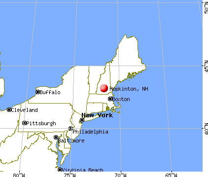
Hopkinton, New Hampshire
Submit your own pictures of this town and show them to the world
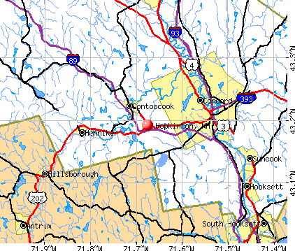
- OSM Map
- General Map
- Google Map
- MSN Map
Population change since 2000: +3.5%
 |
| Males: 2,732 | |
| Females: 2,857 |
| Median resident age: | 45.8 years |
| New Hampshire median age: | 43.9 years |
Zip codes: 03229.
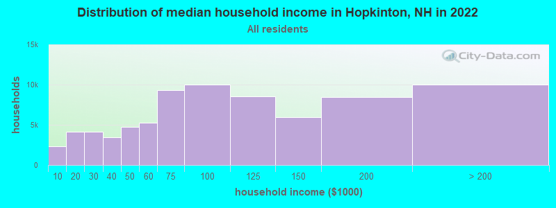
| Hopkinton: | $103,996 |
| NH: | $89,992 |
Estimated per capita income in 2022: $61,601 (it was $30,753 in 2000)
Hopkinton town income, earnings, and wages data
Estimated median house or condo value in 2022: $451,580 (it was $144,300 in 2000)
| Hopkinton: | $451,580 |
| NH: | $384,700 |
Mean prices in 2022: all housing units: $378,901; detached houses: $416,256; townhouses or other attached units: $317,750; in 2-unit structures: $298,869; in 3-to-4-unit structures: $371,619; in 5-or-more-unit structures: $216,601; mobile homes: $110,180; occupied boats, rvs, vans, etc.: $74,347
Detailed information about poverty and poor residents in Hopkinton, NH
Compare current foreclosures near Hopkinton, NH:
| Photo | Address | Area | Beds / Baths | Price | Details |
|---|---|---|---|---|---|

|
#1
Fisherville Rd Unit 21
Concord, NH 03303
|
990 sq. feet
|
1 baths 2 beds |
show details | |

|
#2
-8 Pleasant Street
Suncook, NH 03275
|
2,116 sq. feet
|
2 baths 5 beds |
show details | |

|
#3
Valley Of Industry
Concord, NH 03303
|
2,703 sq. feet
|
1 baths 4 beds |
show details | |

|
#4
N State St
Concord, NH 03301
|
1,920 sq. feet
|
1 baths 3 beds |
show details | |

|
#5
Hampshire Dr
Concord, NH 03301
|
858 sq. feet
|
1 baths 2 beds |
show details | |

|
#6
Mont Vernon Rd
New Boston, NH 03070
|
3,854 sq. feet
|
2 baths 3 beds |
show details | |

|
#7
Center St
Goffstown, NH 03045
|
2,308 sq. feet
|
4 baths 3 beds |
show details | |

|
#8
Forest St
Bradford, NH 03221
|
1,009 sq. feet
|
1 baths 2 beds |
show details | |

|
#9
N State St
Concord, NH 03301
|
6,861 sq. feet
|
7 baths 5 beds |
show details | |

|
#10
Duck Pond Ln
Warner, NH 03278
|
1,120 sq. feet
|
1 baths 3 beds |
show details |
| Photo | Address | Area | Beds / Baths | Price | Details |
|---|---|---|---|---|---|

|
#11
Diamond Ln
Goffstown, NH 03045
|
2,464 sq. feet
|
1 baths 4 beds |
show details | |

|
#12
Wedgewood Cir Unit 9
Hooksett, NH 03106
|
1,942 sq. feet
|
2 baths 2 beds |
show details | |

|
#13
Wallace Rd
Goffstown, NH 03045
|
1,698 sq. feet
|
1 baths 2 beds |
show details | |

|
#14
Van Ger Dr
Bow, NH 03304
|
2,498 sq. feet
|
2 baths 3 beds |
show details | |

|
#15
Hidden Ranch Dr
Hooksett, NH 03106
|
903 sq. feet
|
1 baths 1 beds |
show details | |

|
#16
Forest St
Bradford, NH 03221
|
1,152 sq. feet
|
1 baths 3 beds |
show details | |

|
#17
Hackney C B
Goffstown, NH 03045
|
1,540 sq. feet
|
1 baths 2 beds |
show details | |

|
#18
New Rd
Canterbury, NH 03224
|
3,115 sq. feet
|
2 baths 4 beds |
show details | |

|
#19
Richmond Dr
Concord, NH 03303
|
1,776 sq. feet
|
2 baths 3 beds |
show details | |

|
#20
Longbrook Rd
Goffstown, NH 03045
|
1,960 sq. feet
|
2 baths 3 beds |
show details |
| Photo | Address | Area | Beds / Baths | Price | Details |
|---|---|---|---|---|---|

|
#21
S Fruit St
Concord, NH 03301
|
1,768 sq. feet
|
2 baths 4 beds |
show details | |

|
#22
Abbott Rd
Concord, NH 03303
|
1,386 sq. feet
|
1 baths 2 beds |
show details | |

|
#23
Pinnacle St
Hooksett, NH 03106
|
2,238 sq. feet
|
2 baths 3 beds |
show details | |

|
#24
Etta Ln
Weare, NH 03281
|
1,425 sq. feet
|
1 baths 3 beds |
show details | |

|
#25
Portage Rd
Goffstown, NH 03045
|
1,886 sq. feet
|
1 baths 3 beds |
show details | |

|
#26
Cross Country Rd
Suncook, NH 03275
|
- sq. feet
|
1 baths 3 beds |
show details | |

|
#27
Coral Ave
Manchester, NH 03104
|
2,464 sq. feet
|
2 baths 3 beds |
show details | |

|
#28
Portsmouth St
Concord, NH 03301
|
2,048 sq. feet
|
2 baths 3 beds |
show details | |

|
#29
Whitney Rd
Hillsboro, NH 03244
|
- sq. feet
|
2 baths 3 beds |
show details | |

|
#30
Melody Ln
Hillsboro, NH 03244
|
- sq. feet
|
1 baths 2 beds |
show details |
| Photo | Address | Area | Beds / Baths | Price | Details |
|---|---|---|---|---|---|

|
#31
Blake Rd # A
Weare, NH 03281
|
- sq. feet
|
1 baths 3 beds |
show details | |

|
#32
Hemlock St
Hillsboro, NH 03244
|
- sq. feet
|
2 baths 4 beds |
show details | |

|
#33
Mill St
New Boston, NH 03070
|
- sq. feet
|
3 baths 4 beds |
show details | |

|
#34
Lakeview Dr
Weare, NH 03281
|
- sq. feet
|
2 baths 3 beds |
show details | |

|
#35
Holly Hill Farm Rd
Weare, NH 03281
|
- sq. feet
|
2 baths 3 beds |
show details | |

|
#36
School St
Suncook, NH 03275
|
- sq. feet
|
- baths - beds |
show details | |

|
#37
County Rd
Bradford, NH 03221
|
- sq. feet
|
- baths - beds |
show details | |

|
#38
River St Apt 1k
Franklin, NH 03235
|
- sq. feet
|
- baths - beds |
show details | |

|
#39
High St
Bradford, NH 03221
|
- sq. feet
|
- baths - beds |
show details | |

|
#40
Country Club Dr Apt 29
Manchester, NH 03102
|
- sq. feet
|
- baths - beds |
show details |
| Photo | Address | Area | Beds / Baths | Price | Details |
|---|---|---|---|---|---|

|
#41
Reed St Apt 105
Goffstown, NH 03045
|
- sq. feet
|
- baths - beds |
show details | |

|
#42
Chichester Rd
Loudon, NH 03307
|
- sq. feet
|
- baths - beds |
show details | |

|
#43
Country Club Dr Apt 2
Manchester, NH 03102
|
- sq. feet
|
- baths - beds |
show details | |

|
#44
Swiftwater Dr
Suncook, NH 03275
|
- sq. feet
|
- baths - beds |
show details | |

|
#45
Scribner Rd # 78
Tilton, NH 03276
|
- sq. feet
|
- baths - beds |
show details | |

|
#46
Princeton Dr Unit 304
Hooksett, NH 03106
|
- sq. feet
|
- baths - beds |
show details | |

|
#47
Greenview Dr Apt 11
Manchester, NH 03102
|
- sq. feet
|
- baths - beds |
show details | |

|
#48
Swiftwater Drive Unit No. 2 Aka Unit No. 2c, Building C
Suncook, NH 03275
|
- sq. feet
|
- baths - beds |
show details | |

|
#49
St
Franklin, NH 03235
|
- sq. feet
|
- baths - beds |
show details | |

|
Check over 1 million property listings on Foreclosure.com!
|
browse all offers | |||

- 5,41596.9%White alone
- 601.1%Two or more races
- 551.0%Hispanic
- 320.6%Asian alone
- 160.3%Black alone
- 70.1%American Indian alone
- 30.05%Native Hawaiian and Other
Pacific Islander alone - 10.02%Other race alone

Races in Hopkinton detailed stats: ancestries, foreign born residents, place of birth
According to our research of New Hampshire and other state lists, there were 4 registered sex offenders living in Hopkinton, New Hampshire as of May 29, 2024.
The ratio of all residents to sex offenders in Hopkinton is 1,397 to 1.
The ratio of registered sex offenders to all residents in this city is much lower than the state average.
Type |
2009 |
2010 |
2011 |
2012 |
2013 |
2014 |
2015 |
2016 |
2017 |
2018 |
2019 |
2020 |
2021 |
2022 |
|---|---|---|---|---|---|---|---|---|---|---|---|---|---|---|
| Murders (per 100,000) | 0 (0.0) | 0 (0.0) | 0 (0.0) | 0 (0.0) | 0 (0.0) | 0 (0.0) | 0 (0.0) | 0 (0.0) | 0 (0.0) | 0 (0.0) | 0 (0.0) | 0 (0.0) | 0 (0.0) | 0 (0.0) |
| Rapes (per 100,000) | 0 (0.0) | 0 (0.0) | 0 (0.0) | 0 (0.0) | 0 (0.0) | 1 (17.9) | 0 (0.0) | 0 (0.0) | 0 (0.0) | 0 (0.0) | 1 (17.4) | 0 (0.0) | 1 (17.1) | 1 (16.5) |
| Robberies (per 100,000) | 0 (0.0) | 0 (0.0) | 1 (17.9) | 0 (0.0) | 0 (0.0) | 0 (0.0) | 0 (0.0) | 0 (0.0) | 0 (0.0) | 0 (0.0) | 0 (0.0) | 0 (0.0) | 0 (0.0) | 0 (0.0) |
| Assaults (per 100,000) | 1 (17.8) | 1 (17.9) | 4 (71.5) | 10 (178.4) | 10 (178.6) | 5 (89.3) | 8 (142.7) | 0 (0.0) | 1 (17.8) | 0 (0.0) | 0 (0.0) | 0 (0.0) | 2 (34.2) | 0 (0.0) |
| Burglaries (per 100,000) | 11 (195.9) | 11 (196.8) | 8 (143.0) | 4 (71.4) | 7 (125.0) | 5 (89.3) | 6 (107.0) | 8 (142.5) | 2 (35.5) | 2 (35.2) | 2 (34.7) | 2 (34.6) | 0 (0.0) | 0 (0.0) |
| Thefts (per 100,000) | 31 (552.0) | 34 (608.3) | 47 (839.9) | 51 (909.7) | 47 (839.4) | 31 (553.9) | 19 (338.9) | 34 (605.6) | 23 (408.6) | 26 (457.7) | 16 (277.8) | 24 (415.2) | 30 (512.6) | 14 (230.3) |
| Auto thefts (per 100,000) | 0 (0.0) | 1 (17.9) | 3 (53.6) | 0 (0.0) | 2 (35.7) | 0 (0.0) | 1 (17.8) | 1 (17.8) | 2 (35.5) | 4 (70.4) | 2 (34.7) | 1 (17.3) | 4 (68.4) | 1 (16.5) |
| Arson (per 100,000) | 0 (0.0) | 0 (0.0) | 0 (0.0) | 0 (0.0) | 0 (0.0) | 0 (0.0) | 0 (0.0) | 0 (0.0) | 0 (0.0) | 0 (0.0) | 0 (0.0) | 1 (17.3) | 0 (0.0) | 0 (0.0) |
| City-Data.com crime index | 39.4 | 43.1 | 67.5 | 77.1 | 80.9 | 60.6 | 51.0 | 35.6 | 25.2 | 26.4 | 30.2 | 20.4 | 46.5 | 23.7 |
The City-Data.com crime index weighs serious crimes and violent crimes more heavily. Higher means more crime, U.S. average is 246.1. It adjusts for the number of visitors and daily workers commuting into cities.
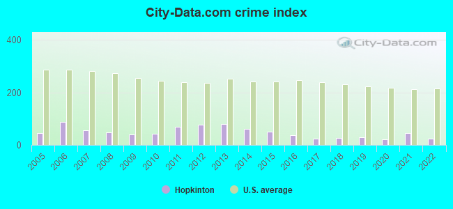
Crime rate in Hopkinton detailed stats: murders, rapes, robberies, assaults, burglaries, thefts, arson
Full-time law enforcement employees in 2021, including police officers: 5 (4 officers - 4 male; 0 female).
| Officers per 1,000 residents here: | 0.68 |
| New Hampshire average: | 2.14 |
 Recent articles from our blog. Our writers, many of them Ph.D. graduates or candidates, create easy-to-read articles on a wide variety of topics.

 | thoughts about moving to Hopkinton, NH (10 replies) |
| Concord Area for Young Family (6 replies) |
| Concord or Manchester Heathcare (18 replies) |
| Hopkinton info needed please (1 reply) |
| Oregon to NH (42 replies) |
| Moving to the Manchester Area - Advice Please :) (13 replies) |
Latest news from Hopkinton, NH collected exclusively by city-data.com from local newspapers, TV, and radio stations
Ancestries: English (28.2%), Irish (19.3%), German (13.0%), French (10.1%), Scottish (7.6%), French Canadian (7.3%).
Current Local Time: EST time zone
Incorporated in 1765
Elevation: 505 feet
Land area: 43.3 square miles.
Population density: 129 people per square mile (very low).
189 residents are foreign born (1.5% North America, 1.3% Europe, 0.4% Latin America).
| This town: | 3.5% |
| New Hampshire: | 4.4% |
| Hopkinton town: | 2.5% ($3,582) |
| New Hampshire: | 2.3% ($2,946) |
Nearest city with pop. 50,000+: Manchester, NH  (19.8 miles , pop. 107,006).
Nearest city with pop. 200,000+: Boston, MA (68.6 miles , pop. 589,141).
Nearest city with pop. 1,000,000+: Bronx, NY (197.4 miles , pop. 1,332,650).
Nearest cities:
), ), ), Latitude: 43.20 N, Longitude: 71.71 W
Area code commonly used in this area: 603

Single-family new house construction building permits:
- 2022: 26 buildings, average cost: $358,400
- 2021: 14 buildings, average cost: $259,200
- 2020: 13 buildings, average cost: $248,200
- 2019: 14 buildings, average cost: $282,200
- 2018: 10 buildings, average cost: $249,800
- 2017: 10 buildings, average cost: $248,100
- 2016: 16 buildings, average cost: $261,800
- 2015: 8 buildings, average cost: $241,400
- 2014: 8 buildings, average cost: $241,400
- 2013: 10 buildings, average cost: $233,900
- 2012: 3 buildings, average cost: $184,000
- 2011: 4 buildings, average cost: $172,800
- 2010: 5 buildings, average cost: $165,900
- 2009: 9 buildings, average cost: $178,900
- 2008: 8 buildings, average cost: $182,400
- 2007: 8 buildings, average cost: $181,200
- 2006: 10 buildings, average cost: $171,000
- 2005: 13 buildings, average cost: $150,200
- 2004: 20 buildings, average cost: $138,800
- 2003: 23 buildings, average cost: $130,700
- 2002: 21 buildings, average cost: $130,700
- 2001: 19 buildings, average cost: $121,400
- 2000: 16 buildings, average cost: $118,000
- 1999: 21 buildings, average cost: $109,200
- 1998: 16 buildings, average cost: $101,700
- 1997: 18 buildings, average cost: $91,700


| Here: | 2.1% |
| New Hampshire: | 2.5% |


- Health care (14.7%)
- Educational services (11.9%)
- Professional, scientific, technical services (11.3%)
- Public administration (8.0%)
- Construction (5.8%)
- Finance & insurance (4.9%)
- Accommodation & food services (2.9%)

- Professional, scientific, technical services (15.6%)
- Construction (10.5%)
- Health care (10.1%)
- Educational services (5.8%)
- Finance & insurance (5.0%)
- Public administration (4.5%)
- Repair & maintenance (3.0%)

- Health care (19.9%)
- Educational services (18.8%)
- Public administration (11.9%)
- Professional, scientific, technical services (6.5%)
- Finance & insurance (4.8%)
- Administrative & support & waste management services (3.7%)
- Used merchandise, gift, novelty, souvenir, other miscellaneous stores (3.4%)

- Other office and administrative support workers, including supervisors (6.1%)
- Other sales and related occupations, including supervisors (5.0%)
- Secretaries and administrative assistants (4.3%)
- Other management occupations, except farmers and farm managers (4.2%)
- Preschool, kindergarten, elementary, and middle school teachers (3.9%)
- Registered nurses (3.8%)
- Counselors, social workers, and other community and social service specialists (2.9%)

- Other sales and related occupations, including supervisors (6.3%)
- Other management occupations, except farmers and farm managers (5.2%)
- Top executives (4.4%)
- Physicians and surgeons (4.3%)
- Electrical equipment mechanics and other installation, maintenance, and repair workers, including supervisors (4.0%)
- Driver/sales workers and truck drivers (3.7%)
- Operations specialties managers, except financial managers (3.7%)

- Other office and administrative support workers, including supervisors (8.9%)
- Secretaries and administrative assistants (8.5%)
- Preschool, kindergarten, elementary, and middle school teachers (7.2%)
- Registered nurses (6.9%)
- Information and record clerks, except customer service representatives (4.7%)
- Other sales and related occupations, including supervisors (3.5%)
- Counselors, social workers, and other community and social service specialists (3.5%)
Average climate in Hopkinton, New Hampshire
Based on data reported by over 4,000 weather stations


(lower is better)

Air Quality Index (AQI) level in 2022 was 52.6. This is better than average.
| City: | 52.6 |
| U.S.: | 72.6 |

Nitrogen Dioxide (NO2) [ppb] level in 2010 was 8.02. This is significantly worse than average. Closest monitor was 7.8 miles away from the city center.
| City: | 8.02 |
| U.S.: | 5.11 |

Sulfur Dioxide (SO2) [ppb] level in 2016 was 1.05. This is significantly better than average. Closest monitor was 7.8 miles away from the city center.
| City: | 1.05 |
| U.S.: | 1.51 |

Ozone [ppb] level in 2022 was 29.4. This is about average. Closest monitor was 8.7 miles away from the city center.
| City: | 29.4 |
| U.S.: | 33.3 |

Tornado activity:
Hopkinton-area historical tornado activity is slightly above New Hampshire state average. It is 43% smaller than the overall U.S. average.
On 7/2/1961, a category F2 (max. wind speeds 113-157 mph) tornado 7.2 miles away from the Hopkinton town center caused between $500 and $5000 in damages.
On 6/9/1953, a category F3 (max. wind speeds 158-206 mph) tornado 40.6 miles away from the town center injured 5 people and caused between $5000 and $50,000 in damages.
Earthquake activity:
Hopkinton-area historical earthquake activity is significantly above New Hampshire state average. It is 71% smaller than the overall U.S. average.On 4/20/2002 at 10:50:47, a magnitude 5.3 (5.3 ML, Depth: 3.0 mi, Class: Moderate, Intensity: VI - VII) earthquake occurred 134.3 miles away from Hopkinton center
On 10/7/1983 at 10:18:46, a magnitude 5.3 (5.1 MB, 5.3 LG, 5.1 ML) earthquake occurred 141.8 miles away from Hopkinton center
On 1/19/1982 at 00:14:42, a magnitude 4.7 (4.5 MB, 4.7 MD, 4.5 LG, Class: Light, Intensity: IV - V) earthquake occurred 21.2 miles away from the city center
On 4/20/2002 at 10:50:47, a magnitude 5.2 (5.2 MB, 4.2 MS, 5.2 MW, 5.0 MW) earthquake occurred 133.9 miles away from the city center
On 10/16/2012 at 23:12:25, a magnitude 4.7 (4.7 ML, Depth: 10.0 mi) earthquake occurred 59.4 miles away from the city center
On 8/21/1996 at 07:54:14, a magnitude 3.8 (3.8 LG, 3.6 LG, Depth: 6.2 mi, Class: Light, Intensity: II - III) earthquake occurred 70.1 miles away from the city center
Magnitude types: regional Lg-wave magnitude (LG), body-wave magnitude (MB), duration magnitude (MD), local magnitude (ML), surface-wave magnitude (MS), moment magnitude (MW)
Natural disasters:
The number of natural disasters in Merrimack County (27) is a lot greater than the US average (15).Major Disasters (Presidential) Declared: 17
Emergencies Declared: 9
Causes of natural disasters: Storms: 13, Floods: 12, Winter Storms: 4, Snowstorms: 3, Hurricanes: 2, Snows: 2, Blizzard: 1, Ice Storm: 1, Snowfall: 1, Tornado: 1, Tropical Storm: 1, Wind: 1, Other: 1 (Note: some incidents may be assigned to more than one category).

Hospitals and medical centers near Hopkinton:
- HEALTHSOUTH REHABILITATION HOSPITAL (Hospital, about 8 miles away; CONCORD, NH)
- CONCORD HOSPITAL Acute Care Hospitals (about 8 miles away; CONCORD, NH)
- NEW HAMPSHIRE KIDNEY CENTER (FMC) (Dialysis Facility, about 8 miles away; CONCORD, NH)
- PLEASANT VIEW CENTER, GENESIS HEALTHCARE (Nursing Home, about 8 miles away; CONCORD, NH)
- PRESIDENTIAL OAKS (Nursing Home, about 8 miles away; CONCORD, NH)
- NEW HAMPSHIRE HOSP-MED SURG BLDG (Hospital, about 9 miles away; CONCORD, NH)
- NEW HAMPSHIRE HOSP-PSYCH UNIT (Hospital, about 9 miles away; CONCORD, NH)
Colleges/universities with over 2000 students nearest to Hopkinton:
- NHTI-Concord's Community College (about 9 miles; Concord, NH; Full-time enrollment: 2,865)
- Southern New Hampshire University (about 18 miles; Manchester, NH; FT enrollment: 16,552)
- Saint Anselm College (about 19 miles; Manchester, NH; FT enrollment: 2,059)
- Mount Washington College (about 21 miles; Manchester, NH; FT enrollment: 2,187)
- Franklin Pierce University (about 35 miles; Rindge, NH; FT enrollment: 2,139)
- Keene State College (about 35 miles; Keene, NH; FT enrollment: 5,098)
- Plymouth State University (about 39 miles; Plymouth, NH; FT enrollment: 4,838)
Public elementary/middle school in Hopkinton:
- HAROLD MARTIN SCHOOL (Students: 276, Location: 271 MAIN ST., Grades: PK-3)
Points of interest:
Notable locations in Hopkinton: Camp Merrimack (A), Gould Hill Orchards (B), Hopkinton Fair Grounds (C), Duston Country Club (D), Bates Library (E), New Hampshire Antiquarian Society Library (F), New Hampshire Antiquarian Society (G), Hopkinton Town Hall (H), Hopkinton Fire Department Hopkinton Station (I), William H Long Memorial Library (J), Hopkinton Fire Department Contoocook Station (K). Display/hide their locations on the map
Churches in Hopkinton include: Saint Andrews Episcopal Church (A), First Congregational Church (B), Saint Marys Church (C). Display/hide their locations on the map
Cemeteries: Old Hop Cemetery (1), Contoocook Cemetery (2), New Cemetery (3), Putney Cemetery (4), Blackwater Cemetery (5). Display/hide their locations on the map
Lakes, reservoirs, and swamps: Carr Pond (A), Clement Pond (B), Kimball Pond (C), Rolf Pond (D), Smith Pond (E), Whittier Pond (F), Contoocook River Reservoir (G), Hopkinton Lake (H). Display/hide their locations on the map
Streams, rivers, and creeks: Warner River (A), Hardy Spring Brook (B), Deer Meadow Brook (C), Cressey Brook (D), Browns Brook (E), Blackwater River (F). Display/hide their locations on the map
Parks in Hopkinton include: Elm Brook Recreation Area (1), Drew Lake Recreation Area (2), Stumpfield-Mudgett Recreation Area (3). Display/hide their locations on the map
Birthplace of: Mary Greenleaf Clement Leavitt - Writer, Alvan Flanders - Politician.
Drinking water stations with addresses in Hopkinton and their reported violations in the past:
STORM FITNESS (Population served: 32, Groundwater):Past health violations:Past monitoring violations:
- MCL, Monthly (TCR) - Between JUL-2012 and SEP-2012, Contaminant: Coliform. Follow-up actions: St Public Notif requested (JUL-20-2012), St Violation/Reminder Notice (JUL-20-2012), St Public Notif received (JUL-31-2012), St Formal NOV issued (AUG-29-2012), St Compliance achieved (FEB-28-2013)
- MCL, Monthly (TCR) - Between APR-2012 and JUN-2012, Contaminant: Coliform. Follow-up actions: St Public Notif requested (JUN-12-2012), St Violation/Reminder Notice (JUN-12-2012), St Public Notif received (JUL-10-2012), St Formal NOV issued (AUG-29-2012), St Compliance achieved (FEB-28-2013)
- Monitoring, Source Water (GWR) - Between NOV-16-2012 and DEC-16-2012, Contaminant: E. COLI. Follow-up actions: St Public Notif requested (DEC-17-2012), St Violation/Reminder Notice (DEC-17-2012), St Public Notif received (DEC-20-2012), St Compliance achieved (DEC-21-2012)
- Monitoring, Repeat Major (TCR) - Between OCT-2012 and DEC-2012, Contaminant: Coliform (TCR). Follow-up actions: St Public Notif requested (DEC-17-2012), St Violation/Reminder Notice (DEC-17-2012), St Public Notif received (DEC-20-2012), St Compliance achieved (DEC-21-2012)
| This town: | 2.5 people |
| New Hampshire: | 2.5 people |
| This town: | 74.0% |
| Whole state: | 66.3% |
| This town: | 6.6% |
| Whole state: | 8.3% |
Likely homosexual households (counted as self-reported same-sex unmarried-partner households)
- Lesbian couples: 0.7% of all households
- Gay men: 0.5% of all households
| This town: | 1.8% |
| Whole state: | 6.5% |
| This town: | 0.7% |
| Whole state: | 2.8% |
For population 15 years and over in Hopkinton:

- Never married: 16.1%
- Now married: 66.7%
- Separated: 1.4%
- Widowed: 5.3%
- Divorced: 10.5%
For population 25 years and over in Hopkinton:
- High school or higher: 95.2%
- Bachelor's degree or higher: 47.0%
- Graduate or professional degree: 20.0%
- Unemployed: 2.8%
- Mean travel time to work (commute): 25.1 minutes


| Here: | 9.9 |
| New Hampshire average: | 10.9 |
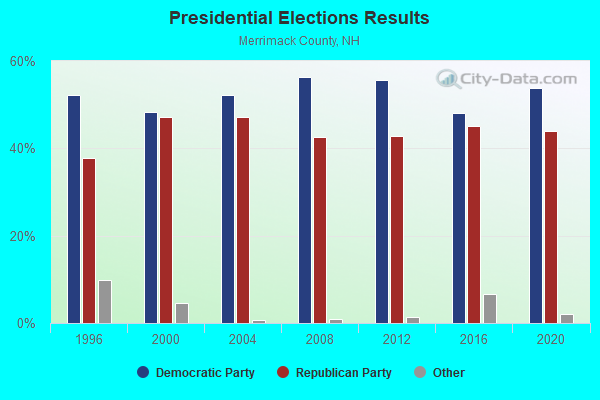
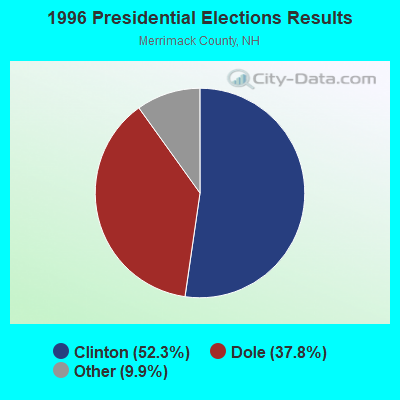
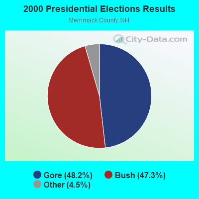
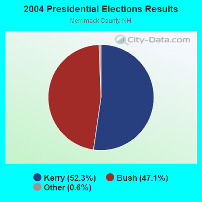

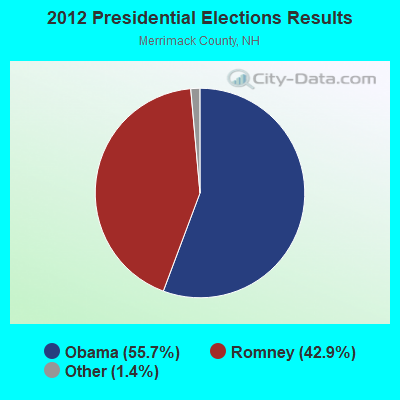
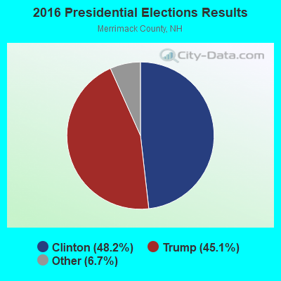
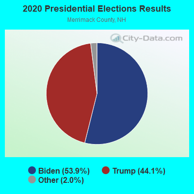
Graphs represent county-level data. Detailed 2008 Election Results
Religion statistics for Hopkinton, NH (based on Merrimack County data)
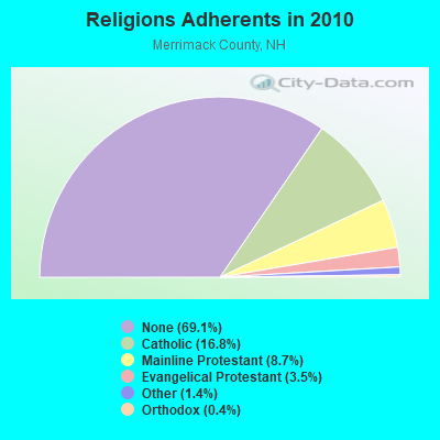
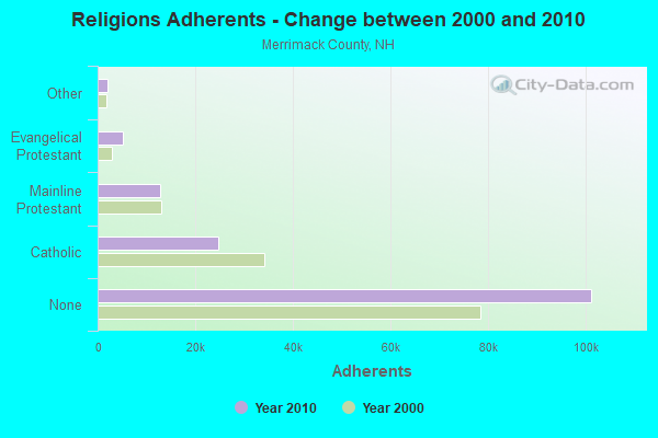
| Religion | Adherents | Congregations |
|---|---|---|
| Catholic | 24,654 | 7 |
| Mainline Protestant | 12,791 | 51 |
| Evangelical Protestant | 5,195 | 36 |
| Other | 2,097 | 15 |
| Orthodox | 580 | 2 |
| None | 101,128 | - |
Food Environment Statistics:
| This county: | 1.82 / 10,000 pop. |
| New Hampshire: | 2.14 / 10,000 pop. |
| Here: | 0.14 / 10,000 pop. |
| State: | 0.15 / 10,000 pop. |
| This county: | 1.22 / 10,000 pop. |
| New Hampshire: | 1.78 / 10,000 pop. |
| Merrimack County: | 4.39 / 10,000 pop. |
| New Hampshire: | 4.02 / 10,000 pop. |
| Here: | 7.77 / 10,000 pop. |
| State: | 9.70 / 10,000 pop. |
| This county: | 7.4% |
| New Hampshire: | 7.6% |
| Here: | 23.8% |
| New Hampshire: | 24.4% |
| Here: | 16.9% |
| State: | 15.9% |
Strongest AM radio stations in Hopkinton:
- WGIR (610 AM; 5 kW; MANCHESTER, NH; Owner: CAPSTAR TX LIMITED PARTNERSHIP)
- WRKO (680 AM; 50 kW; BOSTON, MA; Owner: ENTERCOM BOSTON LICENSE, LLC)
- WKBR (1250 AM; 5 kW; MANCHESTER, NH; Owner: DEVON BROADCASTING COMPANY, INC.)
- WNTK (1020 AM; 10 kW; NEWPORT, NH; Owner: KOOR COMMUNICATIONS, INC.)
- WCRN (830 AM; 50 kW; WORCESTER, MA; Owner: CARTER BROADCASTING CORPORATION)
- WEEI (850 AM; 50 kW; BOSTON, MA; Owner: ENTERCOM BOSTON LICENSE, LLC)
- WKXL (1450 AM; 1 kW; CONCORD, NH; Owner: EMBRO COMMUNICATIONS, LLC)
- WKOX (1200 AM; 50 kW; FRAMINGHAM, MA; Owner: CAPSTAR TX LIMITED PARTNERSHIP)
- WNNZ (640 AM; 50 kW; WESTFIELD, MA; Owner: CLEAR CHANNEL BROADCASTING LICENSES, INC.)
- WBIX (1060 AM; 40 kW; NATICK, MA; Owner: LANGER BROADCASTING CORPORATION)
- WWZN (1510 AM; 50 kW; BOSTON, MA; Owner: ROSE CITY RADIO CORPORATION)
- WBZ (1030 AM; 50 kW; BOSTON, MA; Owner: INFINITY BROADCASTING OPERATIONS, INC.)
- WDER (1320 AM; 10 kW; DERRY, NH; Owner: BLOUNT COMMUNICATIONS, INC. OF NH)
Strongest FM radio stations in Hopkinton:
- WNNH (99.1 FM; HENNIKER, NH; Owner: TELE-MEDIA COMPANY OF NEW HAMPSHIRE, L.L.C.)
- WEVO (89.1 FM; CONCORD, NH; Owner: NEW HAMPSHIRE PUBLIC RADIO)
- WNHI (93.3 FM; BELMONT, NH; Owner: CONCORD BROADCASTING, L.L.C.)
- WGIR-FM (101.1 FM; MANCHESTER, NH; Owner: CAPSTAR TX LIMITED PARTNERSHIP)
- WTPL (107.7 FM; HILLSBORO, NH; Owner: CONCORD BROADCASTING, L.L.C.)
- WQLL (96.5 FM; BEDFORD, NH; Owner: SAGA COMMUNICATIONS OF NEW ENGLAND, LLC)
- WOTX-FM (102.3 FM; CONCORD, NH; Owner: CAPITOL B/CING. INCORPORATION, INC.)
- WLMW (90.7 FM; MANCHESTER, NH; Owner: KNOWLEDGE FOR LIFE)
- WZID (95.7 FM; MANCHESTER, NH; Owner: SAGA COMMUNICATIONS OF NEW ENGLAND, LLC)
- WHDQ (106.1 FM; CLAREMONT, NH; Owner: GREAT NORTHERN RADIO, L.L.C.)
- WJYY (105.5 FM; CONCORD, NH; Owner: CONCORD BROADCASTING, L.L.C.)
- WFEX (92.1 FM; PETERBOROUGH, NH; Owner: FNX BROADCASTING OF NEW HAMPSHIRE LLC)
- W282AF (104.3 FM; CONCORD, NH; Owner: CONCORD BIBLE FELLOWSHIP)
- WVPR (89.5 FM; WINDSOR, VT; Owner: VERMONT PUBLIC RADIO)
- WSCY (106.9 FM; MOULTONBOROUGH, NH; Owner: NORTHEAST COMMUNICATIONS CORPORATION)
- WPKQ (103.7 FM; NORTH CONWAY, NH; Owner: CITADEL BROADCASTING COMPANY)
- WLKZ (104.9 FM; WOLFEBORO, NH; Owner: TELE-MEDIA COMPANY OF NEW HAMPSHIRE, L.L.C.)
- WHOM (94.9 FM; MT. WASHINGTON, NH; Owner: CITADEL BROADCASTING COMPANY)
- WVRR (101.7 FM; NEWPORT, NH; Owner: CAPSTAR TX LIMITED PARTNERSHIP)
- WNTK-FM (99.7 FM; NEW LONDON, NH; Owner: SHEILA E. VINIKOOR)
TV broadcast stations around Hopkinton:
- WMEA-TV (Channel 26; BIDDEFORD, ME; Owner: MAINE PUBLIC BROADCASTING CORP.)
- WENH-TV (Channel 11; DURHAM, NH; Owner: UNIVERSITY OF NEW HAMPSHIRE)
- WMUR-TV (Channel 9; MANCHESTER, NH; Owner: HEARST-ARGYLE PROPERTIES, INC.)
- WPXG (Channel 21; CONCORD, NH; Owner: PAXSON BOSTON-68 LICENSE, INC.)
- W39AR (Channel 39; CONCORD, NH; Owner: CENTER B/CING. CORPORATION OF NEW HAMPSHIRE)
- WNEU (Channel 60; MERRIMACK, NH; Owner: NBC SUBSIDIARY (NH), INC.)

- National Bridge Inventory (NBI) Statistics
- 34Number of bridges
- 364ft / 111mTotal length
- $69,124,000Total costs
- 285,209Total average daily traffic
- 24,714Total average daily truck traffic

- New bridges - historical statistics
- 1Before 1900
- 11900-1909
- 11930-1939
- 191950-1959
- 91960-1969
- 11980-1989
- 21990-1999
FCC Registered Cell Phone Towers:
1- 845 Upper Straw Rd (Lat: 43.185861 Lon: -71.624417), Type: Pole, Structure height: 27.4 m, Call Sign: KNKQ431
Assigned Frequencies: 869.040 MHz, 869.040 MHz, 869.040 MHz, 824.040 MHz, 824.040 MHz, 824.040 MHz, 890.010 MHz, 890.010 MHz, 890.010 MHz, 845.010 MHz, 845.010 MHz, 845.010 MHzGrant Date: 07/06/2017, Expiration Date: 05/20/2027, Certifier: Steven T CampbellRegistrant: Wilkinson Barker Knauer, LLP, 1800 M Street Nw, Suite 800n, Washington, DC 20036, Phone: (202) 383-3420, Fax: (202) 783-5851, Email:
FCC Registered Antenna Towers:
3- Peter M Connolly, 845 Upper Straw Rd (Lat: 43.185861 Lon: -71.624417), Type: 27.4, Overall height: 27.4 m, Registrant: Holland & Knight L.L.P, Pconnolly@hklaw,Com, , Washi-ngton, Phone: (202) 862-5989
- Peter M Connolly, 845 Upper Straw Rd (Lat: 43.185861 Lon: -71.624417), Type: 27.4, Overall height: 27.4 m, Registrant: Holland & Knight L.L.P, Pconnolly@hklaw,Com, , Washi-ngton, Phone: (202) 862-5989
- Cayla Gamble, 845 Upper Straw Rd (Lat: 43.185861 Lon: -71.624417), Type: 27.4, Structure height: 33013 m, Overall height: 27.4 m, Registrant: Wilkinson Barker Knauer, LLP, Gwerner@wbklaw.Com, , Washi-ngton, Phone: (202) 383-3420
FCC Registered Broadcast Land Mobile Towers:
3- Fire Station Rte 103 & Pine St (Lat: 43.223139 Lon: -71.713972), Call Sign: KBG347,
Assigned Frequencies: 154.160 MHz, 154.235 MHz, 154.355 MHz, Grant Date: 04/24/2014, Expiration Date: 04/25/2024, Registrant: Hopkinton, Town Of, 9 Pine St, Contoocook, NH 03229, Phone: (603) 746-3181, Fax: (603) 746-5134, Email:
- Village Fire Station Rt 202 (Lat: 43.188972 Lon: -71.660639), Call Sign: KRB555, Licensee ID: L00008549,
Assigned Frequencies: 31.9000 MHz, Grant Date: 08/08/2001, Expiration Date: 09/18/2011, Cancellation Date: 11/19/2003, Registrant: The State Of New Hampshire, Department Of Resources And Economic Development, 172 Pembroke Road, Concord, NH 03302-1856, Phone: (603) 271-2217, Fax: (603) 271-6488, Email:
- Police Dept Main St (Lat: 43.191750 Lon: -71.672861), Call Sign: KXL281,
Assigned Frequencies: 155.475 MHz, 156.090 MHz, Grant Date: 07/27/2022, Expiration Date: 08/10/2032, Registrant: Nh Dept. Of Safety/Emergency Services And Communications, 33 Hazen Dr (Mailing), Concord, NH 03305, Phone: (603) 528-7541, Fax: (603) 271-6629, Email:
FCC Registered Microwave Towers:
1- NE33XC381, 124 Watchtower Road (Lat: 43.213778 Lon: -71.688083), Type: Ltower, Structure height: 45.7 m, Call Sign: WQXU836,
Assigned Frequencies: 10855.0 MHz, 10855.0 MHz, 10855.0 MHz, 10855.0 MHz, 10855.0 MHz, 10855.0 MHz, 10855.0 MHz, Grant Date: 06/15/2016, Expiration Date: 06/15/2026, Cancellation Date: 05/16/2023, Certifier: David Werblow, Registrant: T-Mobile Usa, Inc., 12920 Se 38th Street, Bellevue, WA 98006, Phone: (425) 383-8401, Email:
FCC Registered Amateur Radio Licenses:
21 (See the full list of FCC Registered Amateur Radio Licenses in Hopkinton)FAA Registered Aircraft:
9 (See the full list of FAA Registered Aircraft in Hopkinton)2002 - 2018 National Fire Incident Reporting System (NFIRS) incidents
- Fire incident types reported to NFIRS in Hopkinton, NH
- 37355.8%Structure Fires
- 20430.5%Outside Fires
- 649.6%Mobile Property/Vehicle Fires
- 274.0%Other
 Based on the data from the years 2002 - 2018 the average number of fires per year is 39. The highest number of reported fires - 79 took place in 2015, and the least - 12 in 2003. The data has a growing trend.
 When looking into fire subcategories, the most incidents belonged to: Structure Fires (55.8%), and Outside Fires (30.5%).
- 69.5%Fuel oil, kerosene, etc.
- 20.6%Bottled, tank, or LP gas
- 4.7%Electricity
- 4.5%Wood
- 0.3%Utility gas
- 0.3%Other fuel

- 72.7%Fuel oil, kerosene, etc.
- 8.0%Bottled, tank, or LP gas
- 6.6%Wood
- 6.3%Electricity
- 4.2%Utility gas
- 2.1%Other fuel
Hopkinton compared to New Hampshire state average:
- Unemployed percentage significantly below state average.
- Black race population percentage significantly below state average.
- Hispanic race population percentage significantly below state average.
- Foreign-born population percentage below state average.
- Renting percentage below state average.
- Length of stay since moving in significantly above state average.
- Number of rooms per house significantly below state average.
- House age significantly below state average.
- Percentage of population with a bachelor's degree or higher above state average.
Hopkinton on our top lists:
- #10 on the list of "Top 101 cities with largest percentage of males in occupations: therapists (population 5,000+)"
- #11 on the list of "Top 101 cities with largest percentage of females in industries: miscellaneous nondurable goods merchant wholesalers (population 5,000+)"
- #13 on the list of "Top 101 cities with largest percentage of males in industries: radio, tv, and computer stores (population 5,000+)"
- #17 on the list of "Top 101 cities with largest percentage of females in occupations: judges, magistrates, and other judicial workers (population 5,000+)"
- #20 on the list of "Top 101 cities with largest percentage of males in occupations: other construction workers and helpers (population 5,000+)"
- #20 on the list of "Top 101 cities with largest percentage of males in industries: health care (population 5,000+)"
- #21 on the list of "Top 101 cities with largest percentage of males in occupations: counselors, social workers, and other community and social service specialists (population 5,000+)"
- #22 on the list of "Top 101 cities with largest percentage of males in occupations: secondary school teachers (population 5,000+)"
- #24 on the list of "Top 101 cities with largest percentage of males in industries: petroleum and petroleum products merchant wholesalers (population 5,000+)"
- #25 on the list of "Top 101 cities with largest percentage of females in industries: used merchandise, gift, novelty, and souvenir, and other miscellaneous stores (population 5,000+)"
- #27 on the list of "Top 101 cities with largest percentage of males in occupations: business operations specialists (population 5,000+)"
- #30 on the list of "Top 101 cities with the lowest number of auto thefts per 100,000 residents (population 5,000+)"
- #48 on the list of "Top 101 cities with largest percentage of males in industries: office supplies and stationery stores (population 5,000+)"
- #49 on the list of "Top 101 cities with the largest city-data.com crime index increase from 2002 to 2012 (population 5,000+)"
- #62 on the list of "Top 101 cities with largest percentage of males in industries: other direct selling establishments (population 5,000+)"
- #75 on the list of "Top 101 cities with largest percentage of males in industries: social assistance (population 5,000+)"
- #78 on the list of "Top 101 cities with the lowest number of burglaries per 100,000 residents (population 5,000+)"
- #81 on the list of "Top 101 cities with largest percentage of females in industries: fuel dealers (population 5,000+)"
- #87 (03229) on the list of "Top 101 zip codes with the largest percentage of English first ancestries (pop 5,000+)"
- #30 on the list of "Top 101 counties with the lowest number of births per 1000 residents 2007-2013"
- #37 on the list of "Top 101 counties with the best general health status score of residents (1-5), 3 years of data"
- #46 on the list of "Top 101 counties with the highest percentage of residents that visited a dentist within the past year"
- #68 on the list of "Top 101 counties with the highest percentage of residents that keep firearms around their homes"
- #73 on the list of "Top 101 counties with the lowest Sulfur Oxides Annual air pollution readings in 2012 (µg/m3)"

|
|
Total of 61 patent applications in 2008-2024.