Holladay, Tennessee

Holladay: Misty sunrise over Kentucky Lake at Eva, Tennessee
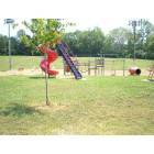
Holladay: School yard in Holladay, Tn
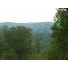
Holladay: View from the Bluff on our property in Holladay, Tn
- add
your
Submit your own pictures of this place and show them to the world
- OSM Map
- General Map
- Google Map
- MSN Map

| Males: 964 | |
| Females: 978 |
| Median resident age: | 39.6 years |
| Tennessee median age: | 35.9 years |
Zip code: 38341
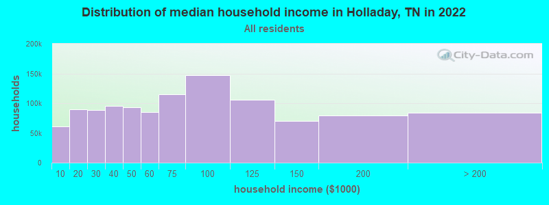
| Holladay: | $48,332 |
| TN: | $65,254 |
Estimated per capita income in 2022: $26,024 (it was $13,767 in 2000)
Holladay CCD income, earnings, and wages data
Estimated median house or condo value in 2022: $102,197 (it was $46,700 in 2000)
| Holladay: | $102,197 |
| TN: | $284,800 |
Mean prices in 2022: all housing units: $176,557; detached houses: $205,350; townhouses or other attached units: $170,025; in 2-unit structures: $96,183; mobile homes: $77,997
Detailed information about poverty and poor residents in Holladay, TN


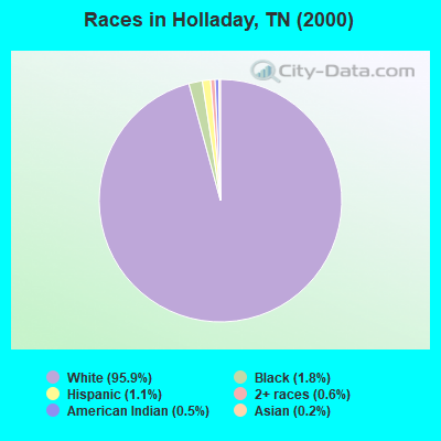
- 1,90795.9%White alone
- 361.8%Black alone
- 211.1%Hispanic
- 110.6%Two or more races
- 100.5%American Indian alone
- 40.2%Asian alone
Races in Holladay detailed stats: ancestries, foreign born residents, place of birth
According to our research of Tennessee and other state lists, there were 13 registered sex offenders living in Holladay, Tennessee as of June 03, 2024.
The ratio of all residents to sex offenders in Holladay is 149 to 1.
 Recent articles from our blog. Our writers, many of them Ph.D. graduates or candidates, create easy-to-read articles on a wide variety of topics.
Current Local Time: CST time zone
Land area: 119.4 square miles.
Population density: 16 people per square mile (very low).

| Holladay CCD: | 0.6% ($259) |
| Tennessee: | 0.8% ($715) |
Nearest city with pop. 50,000+: Jackson, TN  (46.4 miles , pop. 59,643).
Nearest city with pop. 200,000+: Metropolitan Government, TN (74.6 miles , pop. 569,891).
Nearest city with pop. 1,000,000+: Chicago, IL (412.2 miles , pop. 2,896,016).
Nearest cities:
), ), ), ), )Latitude: 35.89 N, Longitude: 88.06 W

| Here: | 3.7% |
| Tennessee: | 3.0% |
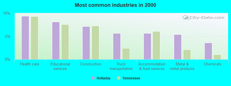
- Health care (9.4%)
- Educational services (8.1%)
- Construction (7.2%)
- Truck transportation (5.7%)
- Accommodation & food services (5.7%)
- Metal & metal products (5.4%)
- Chemicals (3.6%)
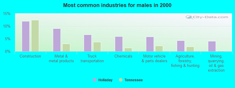
- Construction (12.0%)
- Metal & metal products (9.1%)
- Truck transportation (6.6%)
- Chemicals (6.0%)
- Motor vehicle & parts dealers (5.8%)
- Agriculture, forestry, fishing & hunting (4.3%)
- Mining, quarrying, oil & gas extraction (4.1%)
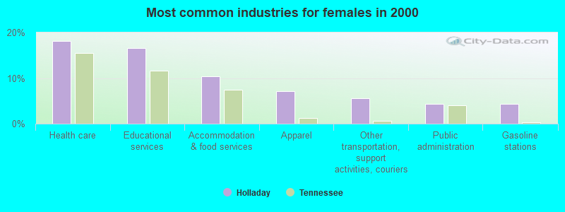
- Health care (18.2%)
- Educational services (16.6%)
- Accommodation & food services (10.5%)
- Apparel (7.1%)
- Other transportation, support activities, couriers (5.5%)
- Public administration (4.3%)
- Gasoline stations (4.3%)
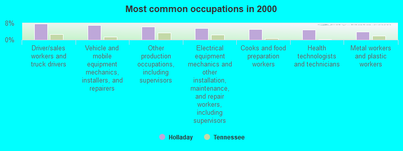
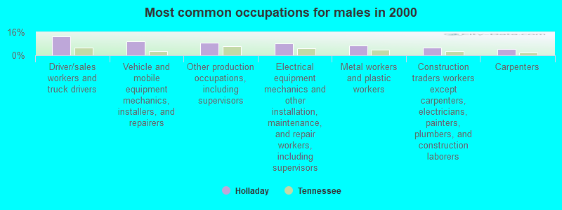
- Driver/sales workers and truck drivers (7.8%)
- Vehicle and mobile equipment mechanics, installers, and repairers (6.9%)
- Other production occupations, including supervisors (6.3%)
- Electrical equipment mechanics and other installation, maintenance, and repair workers, including supervisors (5.7%)
- Cooks and food preparation workers (5.1%)
- Health technologists and technicians (4.8%)
- Metal workers and plastic workers (4.0%)
- Driver/sales workers and truck drivers (13.0%)
- Vehicle and mobile equipment mechanics, installers, and repairers (9.7%)
- Other production occupations, including supervisors (8.7%)
- Electrical equipment mechanics and other installation, maintenance, and repair workers, including supervisors (8.0%)
- Metal workers and plastic workers (6.6%)
- Construction traders workers except carpenters, electricians, painters, plumbers, and construction laborers (5.6%)
- Carpenters (4.1%)
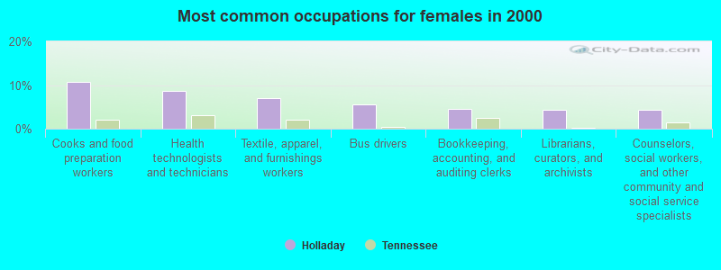
- Cooks and food preparation workers (10.8%)
- Health technologists and technicians (8.6%)
- Textile, apparel, and furnishings workers (7.1%)
- Bus drivers (5.5%)
- Bookkeeping, accounting, and auditing clerks (4.6%)
- Librarians, curators, and archivists (4.3%)
- Counselors, social workers, and other community and social service specialists (4.3%)
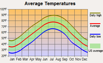
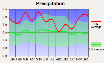
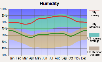
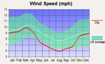
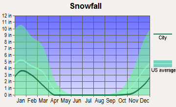
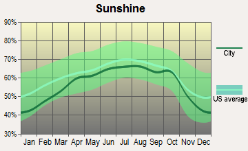
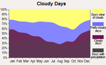
Average climate in Holladay, Tennessee
Based on data reported by over 4,000 weather stations
(lower is better)
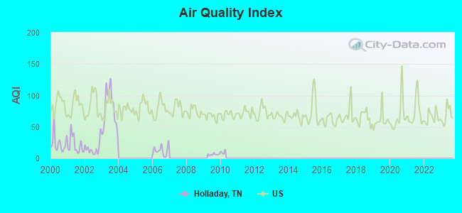
Air Quality Index (AQI) level in 2009 was 6.16. This is significantly better than average.
| City: | 6.16 |
| U.S.: | 72.56 |
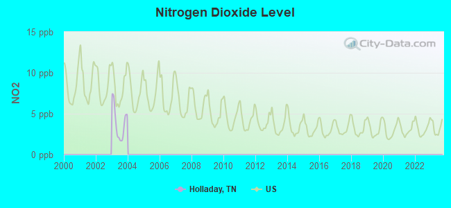
Nitrogen Dioxide (NO2) [ppb] level in 2003 was 3.86. This is better than average. Closest monitor was 12.0 miles away from the city center.
| City: | 3.86 |
| U.S.: | 5.11 |
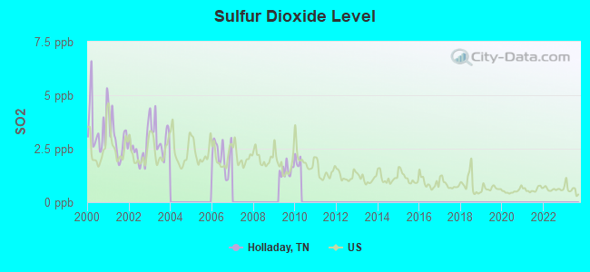
Sulfur Dioxide (SO2) [ppb] level in 2009 was 1.49. This is about average. Closest monitor was 6.4 miles away from the city center.
| City: | 1.49 |
| U.S.: | 1.51 |
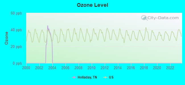
Ozone [ppb] level in 2003 was 33.2. This is about average. Closest monitor was 12.4 miles away from the city center.
| City: | 33.2 |
| U.S.: | 33.3 |
Tornado activity:
Holladay-area historical tornado activity is slightly above Tennessee state average. It is 73% greater than the overall U.S. average.
On 5/7/1971, a category F4 (max. wind speeds 207-260 mph) tornado 8.8 miles away from the Holladay place center killed 3 people and injured 137 people and caused between $500,000 and $5,000,000 in damages.
On 4/3/1956, a category F4 tornado 19.7 miles away from the place center killed 3 people and injured 60 people and caused between $500,000 and $5,000,000 in damages.
Earthquake activity:
Holladay-area historical earthquake activity is significantly above Tennessee state average. It is 279% greater than the overall U.S. average.On 4/18/2008 at 09:36:59, a magnitude 5.4 (5.1 MB, 4.8 MS, 5.4 MW, 5.2 MW, Class: Moderate, Intensity: VI - VII) earthquake occurred 177.6 miles away from Holladay center
On 5/4/1991 at 01:18:54, a magnitude 5.0 (4.4 MB, 4.6 LG, 5.0 LG, Depth: 3.1 mi) earthquake occurred 109.1 miles away from Holladay center
On 9/26/1990 at 13:18:51, a magnitude 5.0 (4.7 MB, 4.8 LG, 5.0 LG, Depth: 7.7 mi) earthquake occurred 120.7 miles away from the city center
On 3/25/1976 at 00:41:20, a magnitude 5.0 (4.9 MB, 5.0 LG) earthquake occurred 128.6 miles away from the city center
On 4/18/2008 at 09:36:59, a magnitude 5.2 (5.2 MW, Depth: 8.9 mi) earthquake occurred 177.5 miles away from the city center
On 6/18/2002 at 17:37:15, a magnitude 5.0 (4.3 MB, 4.6 MW, 5.0 LG) earthquake occurred 146.0 miles away from Holladay center
Magnitude types: regional Lg-wave magnitude (LG), body-wave magnitude (MB), surface-wave magnitude (MS), moment magnitude (MW)
Natural disasters:
The number of natural disasters in Benton County (16) is near the US average (15).Major Disasters (Presidential) Declared: 12
Emergencies Declared: 1
Causes of natural disasters: Storms: 12, Tornadoes: 10, Floods: 9, Winds: 7, Flash Flood: 1, Hurricane: 1, Ice Storm: 1, Winter Storm: 1, Other: 1 (Note: some incidents may be assigned to more than one category).
Hospitals and medical centers near Holladay:
- CAMDEN GENERAL HOSPITAL Critical Access Hospitals (about 12 miles away; CAMDEN, TN)
- CAMDEN HLTHCARE AND REHAB CENTER (Nursing Home, about 12 miles away; CAMDEN, TN)
- HILLHAVEN CONVALESCENT CENTER CAMDEN (Nursing Home, about 12 miles away; CAMDEN, TN)
- TENNESSEE QUALITY HOMECARE NW (Home Health Center, about 13 miles away; CAMDEN, TN)
- LIFE CARE CENTER OF BRUCETON-HOLLOW ROCK (Nursing Home, about 15 miles away; BRUCETON, TN)
Colleges/universities with over 2000 students nearest to Holladay:
- Bethel University (about 31 miles; McKenzie, TN; Full-time enrollment: 5,878)
- Jackson State Community College (about 45 miles; Jackson, TN; FT enrollment: 2,958)
- Union University (about 48 miles; Jackson, TN; FT enrollment: 4,051)
- Murray State University (about 53 miles; Murray, KY; FT enrollment: 8,930)
- The University of Tennessee-Martin (about 55 miles; Martin, TN; FT enrollment: 7,013)
- Columbia State Community College (about 57 miles; Columbia, TN; FT enrollment: 3,383)
- Austin Peay State University (about 60 miles; Clarksville, TN; FT enrollment: 8,621)
Public high school in Holladay:
- HOLLADAY ELEMENTARY (Students: 188, Location: 148 STOKES RD, Grades: KG-9)
Points of interest:
Notable locations in Holladay: Frog Alley (A), West Sycamore Landing (B), West Dixie Landing (C), West Cuba Landing (D), Sugar Tree Marina (E), Pavatt Landing (F), Lees Point Landing (G), Crab Place (H), Byrds Landing (I), Barnett Landing (J), Birdsong Dock and Resort (K), Datrallo landing (L), Gossetts Landing (M), McCauleys Bluff Landing (N), Thompsons Point Landing (O), West Shipps Landing (P), Walkers Landing (Q), Brevards Landing (R), Ledbetter Landing (S), Nix Landing (T). Display/hide their locations on the map
Churches in Holladay include: Liberty Church (A), Union Baptist Church (B), Palestine Church (C), Cantrell Chapel (D), Moores Chapel Methodist Church (E), McIllwain Methodist Church (F), Flatwoods Baptist Church (G), Eagle Creek Baptist Church (H), Dry Branch Church (I). Display/hide their locations on the map
Cemeteries: Tippitt Cemetery (1), Willbanks Cemetery (2), Liberty Cemetery (3), Baber Cemetery (4), Baker Cemetery (5), Shiloh Cemetery (6), Palestine Cemetery (7). Display/hide their locations on the map
Reservoir: Lester Jackson Lake (A). Display/hide its location on the map
Streams, rivers, and creeks: Little Birdsong Creek (A), Ballard Branch (B), Hauk Hatley Branch (C), Green Hatley Branch (D), Fourteen Creek (E), Haggard Branch (F), Eagle Creek (G), Coon Creek (H), Conley Branch (I). Display/hide their locations on the map
Park in Holladay: Tennessee National Wildlife Refuge (1). Display/hide its location on the map
Hotel: Holladay Days Inn (13845 Highway 641 North) (1). Display/hide its approximate location on the map
Drinking water stations with addresses in Holladay and their reported violations in the past:
DRY BRANCH WATER SYSTEM (Population served: 52, Groundwater):Past health violations:Past monitoring violations:
- MCL, Monthly (TCR) - In JUN-2009, Contaminant: Coliform. Follow-up actions: St Public Notif received (MAY-14-2009), St Compliance achieved (JUL-31-2009), St Public Notif requested (AUG-04-2009), St Violation/Reminder Notice (AUG-04-2009), St Formal NOV issued (MAY-11-2010), St Show-cause Hearing (MAY-25-2010), St BCA signed (MAY-25-2010)
- Monitoring, Source Water (GWR) - In FEB-01-2010, Contaminant: E. COLI. Follow-up actions: St Violation/Reminder Notice (NOV-10-2010), St Public Notif requested (NOV-10-2010)
- Monitoring, Repeat Major (TCR) - In JAN-2010, Contaminant: Coliform (TCR). Follow-up actions: St Public Notif requested (MAR-01-2010), St Violation/Reminder Notice (MAR-01-2010), St Compliance achieved (MAR-31-2010), St Formal NOV issued (MAY-11-2010), St Show-cause Hearing (MAY-25-2010), St BCA signed (MAY-25-2010)
- Monitoring and Reporting (DBP) - Between OCT-2006 and DEC-2006, Contaminant: Chlorine. Follow-up actions: St Violation/Reminder Notice (NOV-15-2006), St Public Notif requested (NOV-15-2006), St Compliance achieved (JAN-01-2007)
- Monitoring and Reporting (DBP) - Between JAN-2005 and MAR-2005, Contaminant: Chlorine. Follow-up actions: St Violation/Reminder Notice (FEB-28-2005), St Public Notif requested (FEB-28-2005), St Compliance achieved (APR-01-2005), St Public Notif received (FEB-28-2006)
- 2 routine major monitoring violations
- One minor monitoring violation
- 66 regular monitoring violations
| This place: | 2.5 people |
| Tennessee: | 2.5 people |
| This place: | 66.7% |
| Whole state: | 69.8% |
| This place: | 5.9% |
| Whole state: | 4.2% |
No gay or lesbian households reported
| This place: | 22.1% |
| Whole state: | 13.5% |
| This place: | 13.3% |
| Whole state: | 5.8% |
For population 15 years and over in Holladay:
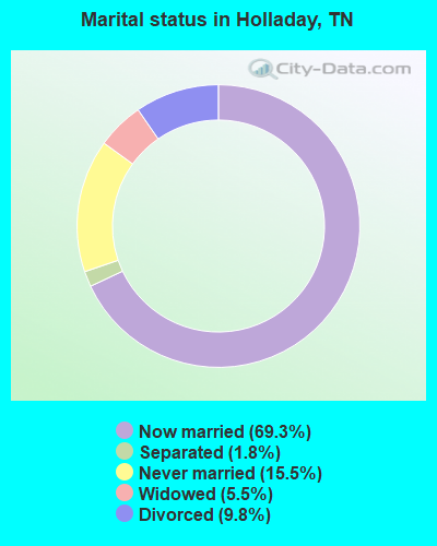
- Never married: 15.5%
- Now married: 69.3%
- Separated: 1.8%
- Widowed: 5.5%
- Divorced: 9.8%
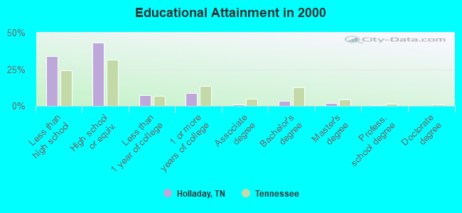
For population 25 years and over in Holladay:
- High school or higher: 66.0%
- Bachelor's degree or higher: 5.7%
- Graduate or professional degree: 2.3%
- Unemployed: 7.7%
- Mean travel time to work (commute): 35.4 minutes
| Here: | 11.6 |
| Tennessee average: | 13.3 |
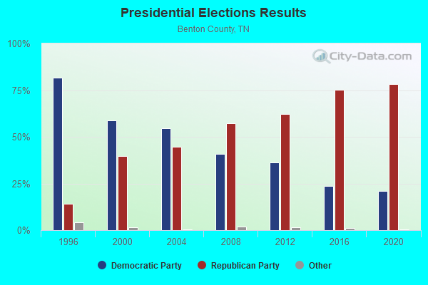
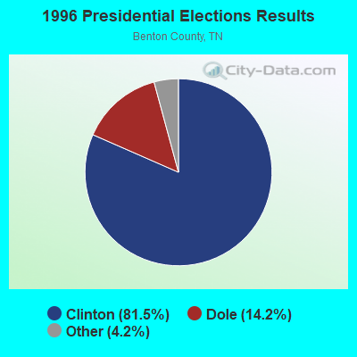
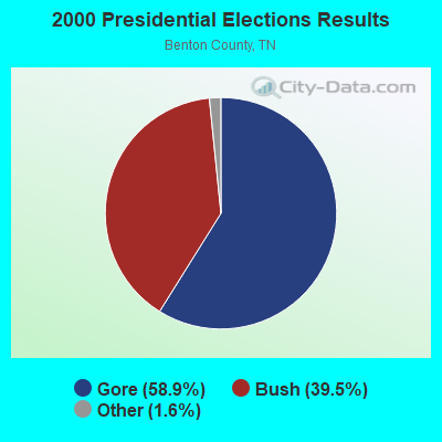
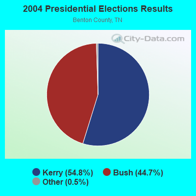
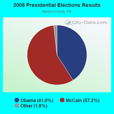

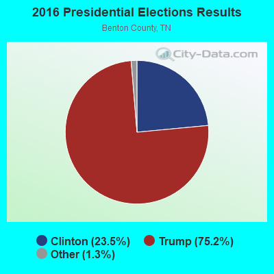
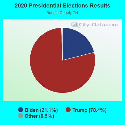
Graphs represent county-level data. Detailed 2008 Election Results
Religion statistics for Holladay, TN (based on Benton County data)
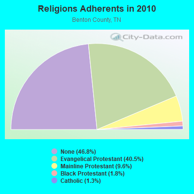
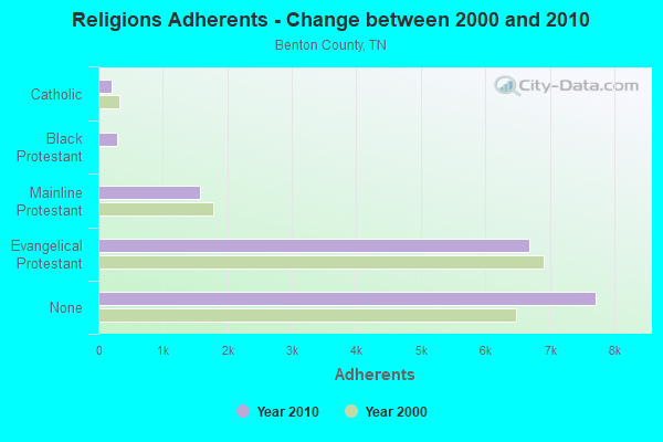
| Religion | Adherents | Congregations |
|---|---|---|
| Evangelical Protestant | 6,685 | 37 |
| Mainline Protestant | 1,579 | 15 |
| Black Protestant | 295 | 2 |
| Catholic | 212 | 1 |
| Other | 1 | 1 |
| None | 7,717 | - |
Food Environment Statistics:
| This county: | 2.46 / 10,000 pop. |
| State: | 1.99 / 10,000 pop. |
| This county: | 8.00 / 10,000 pop. |
| Tennessee: | 5.16 / 10,000 pop. |
| Benton County: | 11.08 / 10,000 pop. |
| Tennessee: | 6.56 / 10,000 pop. |
| Here: | 13.7% |
| Tennessee: | 11.4% |
| Benton County: | 29.7% |
| State: | 30.2% |
| Benton County: | 16.8% |
| Tennessee: | 13.5% |
Businesses in Holladay, TN
- Days Inn: 1
- FedEx: 1
- Subway: 1
Strongest AM radio stations in Holladay:
- WSM (650 AM; 50 kW; NASHVILLE, TN; Owner: GAYLORD ENTERTAINMENT COMPANY)
- WKDA (1200 AM; 50 kW; NASHVILLE, TN; Owner: RADIO NASHVILLE, INC.)
- WNQM (1300 AM; 50 kW; NASHVILLE, TN; Owner: WNQM. INC.)
- WAMB (1160 AM; 50 kW; DONELSON, TN; Owner: GREAT SOUTHERN BROADCASTING COMPANY, INC.)
- WLAC (1510 AM; 50 kW; NASHVILLE, TN; Owner: CAPSTAR TX LIMITED PARTNERSHIP)
- WCRV (640 AM; 50 kW; COLLIERVILLE, TN; Owner: BOTT BROADCASTING COMPANY/TENNESSEE)
- WMUF (1000 AM; daytime; 5 kW; PARIS, TN; Owner: BENTON-WEATHERFORD B/CTING OF TN,INC)
- WGSF (1030 AM; 50 kW; MEMPHIS, TN; Owner: FLINN BROADCASTING CORPORATION)
- WDIA (1070 AM; 50 kW; MEMPHIS, TN; Owner: CLEAR CHANNEL BROADCASTING LICENSES, INC.)
- WPHC (1060 AM; daytime; 1 kW; WAVERLY, TN)
- WMQM (1600 AM; 50 kW; LAKELAND, TN; Owner: WMQM, INC.)
- WLOR (1550 AM; 50 kW; HUNTSVILLE, AL; Owner: BCA RADIO, LLC)
- WNKX (1570 AM; 5 kW; CENTERVILLE, TN; Owner: HICKMAN COUNTY BROADCASTING CO., INC.)
Strongest FM radio stations in Holladay:
- WFGZ (94.5 FM; LOBELVILLE, TN; Owner: OHIO BROADCAST ASSOCIATES)
- WAYW (89.9 FM; NEW JOHNSONVILLE, TN; Owner: WAY-FM MEDIA GROUP, INC.)
- WRJB (95.9 FM; CAMDEN, TN; Owner: COMMUNITY BROADCASTING SERVICES, INC)
- WMUF-FM (104.7 FM; HENRY, TN; Owner: BENTON WEATHERFORD B/C INC OF TN)
- WYNU (92.3 FM; MILAN, TN; Owner: CAPSTAR TX LIMITED PARTNERSHIP)
- WWYN (106.9 FM; MCKENZIE, TN; Owner: RAINBOW MEDIA, INC.)
- WKJQ-FM (97.3 FM; PARSONS, TN; Owner: CLENNEY BROADCASTING CORPORATION)
- WTPR-FM (101.5 FM; MCKINNON, TN; Owner: WENK BROADCAST GROUP)
- WVRY (105.1 FM; WAVERLY, TN; Owner: REACH SATELLITE NETWORK, INC.)
- WBFG (96.5 FM; PARKER'S CROSSROADS, TN; Owner: CROSSROADS BROADCASTING, LLC)
- WLVS-FM (106.5 FM; CLIFTON, TN; Owner: GOLD COAST BROADCASTING CO.)
- WVHR (100.9 FM; HUNTINGDON, TN; Owner: MILAN BROADCASTING COMPANY, INC.)
TV broadcast stations around Holladay:
- WBBJ-TV (Channel 7; JACKSON, TN; Owner: TENNESSEE BROADCASTING PARTNERS)
Holladay fatal accident list:
Jun 24, 2008 02:45 PM, Sr-192, Stokes Rd, Lat: 35.871720, Lon: -88.144110, Vehicles: 1, Persons: 1, Fatalities: 1, Drunk persons involved: 1
FCC Registered Cell Phone Towers:
3 (See the full list of FCC Registered Cell Phone Towers in Holladay)FCC Registered Antenna Towers:
80 (See the full list of FCC Registered Antenna Towers)FCC Registered Private Land Mobile Towers:
1- Hickerson Rd (Lat: 35.820556 Lon: -88.161944), Type: Tower, Structure height: 73.1 m, Overall height: 76.2 m, Call Sign: WPSF278,
Assigned Frequencies: 929.787 MHz, Grant Date: 04/03/2001, Expiration Date: 04/03/2011, Cancellation Date: 11/02/2001, Certifier: Joseph F Mullin, Registrant: Wilkinson Barker Knauer And Quinn, 2300 North Street Nw Suite 700, Washington, DC 20037, Phone: (202) 783-4141, Fax: (202) 783-5851, Email:
FCC Registered Microwave Towers:
7- NA33XC073, 20 Lakeview Trail (Lat: 35.866389 Lon: -87.970833), Type: Ltower, Structure height: 81.4 m, Call Sign: WQRI864,
Assigned Frequencies: 10815.0 MHz, 10815.0 MHz, 10815.0 MHz, 10815.0 MHz, 10815.0 MHz, 10815.0 MHz, Grant Date: 05/23/2013, Expiration Date: 05/23/2023, Cancellation Date: 04/28/2023, Certifier: David Werblow, Registrant: T-Mobile Usa, Inc., 12920 Se 38th Street, Bellevue, WA 98006, Phone: (425) 383-8401, Email:
- NATCHEZ TRAC, 1000 County Corner Rd (Lat: 35.820889 Lon: -88.168917), Type: Ltower, Structure height: 85.6 m, Overall height: 91.4 m, Call Sign: WQRK721,
Assigned Frequencies: 10755.0 MHz, 10755.0 MHz, 10755.0 MHz, 10755.0 MHz, 10715.0 MHz, 10715.0 MHz, 10715.0 MHz, 10715.0 MHz, Grant Date: 07/11/2023, Expiration Date: 06/06/2033, Certifier: Chris Harris, Registrant: Conterra Ultra Broadband, LLC, 2101 Rexford Rd, Ste 200e, Charlotte, NC 28211, Phone: (704) 936-1801, Fax: (704) 936-1801, Email:
- MP33XC003, 367 Peterson Loop (308884) (Lat: 35.818167 Lon: -88.157389), Type: Ltower, Structure height: 74.7 m, Overall height: 79.2 m, Call Sign: WQRT632,
Assigned Frequencies: 17865.0 MHz, 17865.0 MHz, 17865.0 MHz, 17865.0 MHz, 17865.0 MHz, 17865.0 MHz, Grant Date: 07/24/2013, Expiration Date: 07/24/2023, Cancellation Date: 08/23/2021, Certifier: Kyle B Entz, Registrant: T-Mobile Usa, Inc., 12920 Se 38th Street, Bellevue, WA 98006, Phone: (425) 383-8401, Fax: (425) 383-4840, Email:
- MP33XC029, 1917 Shiloh Road (Lat: 35.815972 Lon: -88.205806), Type: Ltower, Structure height: 60.9 m, Overall height: 62.7 m, Call Sign: WQRT635,
Assigned Frequencies: 11385.0 MHz, 11425.0 MHz, 11385.0 MHz, 11425.0 MHz, 11385.0 MHz, 11425.0 MHz, 11385.0 MHz, 11425.0 MHz, 11385.0 MHz, 11425.0 MHz, 11385.0 MHz, 11425.0 MHz, Grant Date: 07/24/2013, Expiration Date: 07/24/2023, Cancellation Date: 05/08/2023, Certifier: Jenny Knopf, Registrant: T-Mobile Usa, Inc., 12920 Se 38th Street, Bellevue, WA 98006, Phone: (425) 383-8401, Email:
- SUGAR TREE, 50 Cox Road (Lat: 35.844917 Lon: -88.089472), Type: Gtower, Structure height: 124.1 m, Overall height: 128.9 m, Call Sign: WQSY741,
Assigned Frequencies: 11015.0 MHz, 5945.20 MHz, 5974.85 MHz, 6004.50 MHz, 6034.15 MHz, 11055.0 MHz, 11095.0 MHz, 11135.0 MHz, 11175.0 MHz, Grant Date: 11/07/2023, Expiration Date: 12/10/2033, Certifier: John E Monday, Registrant: At&t Services, Inc., 208 S Akard St, 20f, Dallas, TX 75202, Phone: (855) 699-7073, Email:
- 9ME0069A, 367 Peterson Loop (308884) (Lat: 35.818167 Lon: -88.157389), Type: Ltower, Structure height: 74.7 m, Overall height: 79.2 m, Call Sign: WQWH364,
Assigned Frequencies: 11545.0 MHz, 11585.0 MHz, 11545.0 MHz, 11585.0 MHz, 11545.0 MHz, 11585.0 MHz, 11545.0 MHz, 11585.0 MHz, 11545.0 MHz, 11585.0 MHz... (+10 more), Grant Date: 08/21/2015, Expiration Date: 08/21/2025, Certifier: David Werblow, Registrant: T-Mobile Usa, Inc., 12920 Se 38th Street, Bellevue, WA 98006, Phone: (425) 383-8401, Fax: (425) 383-4040, Email:
- 9ME3029S, 1917 Shiloh Road (Lat: 35.815972 Lon: -88.205806), Type: Ltower, Structure height: 60.9 m, Overall height: 62.7 m, Call Sign: WRTI878,
Assigned Frequencies: 11265.0 MHz, 11305.0 MHz, 11265.0 MHz, 11305.0 MHz, 11265.0 MHz, 11305.0 MHz, 11265.0 MHz, 11305.0 MHz, 11265.0 MHz, 11305.0 MHz... (+10 more), Grant Date: 06/22/2022, Expiration Date: 06/22/2032, Certifier: Jenny Knopf, Registrant: T-Mobile Usa, Inc., 12920 Se 38th Street, Bellevue, WA 98006, Phone: (425) 383-8401, Fax: (425) 383-4040, Email:
FCC Registered Amateur Radio Licenses:
15 (See the full list of FCC Registered Amateur Radio Licenses in Holladay)FAA Registered Aircraft:
1- Aircraft: AERO COMMANDER 100 (Category: Land, Seats: 4, Weight: Up to 12,499 Pounds, Speed: 75 mph), Engine: LYCOMING 0-320 SERIES (180 HP) (Reciprocating)
N-Number: 3770X, N3770X, N-3770X, Serial Number: 262, Year manufactured: 1968, Certificate Issue Date: 07/29/2019
Registrant (Individual): Robert M Laux, 95 Holladay Home Circle, Holladay, TN 38341
2002 - 2018 National Fire Incident Reporting System (NFIRS) incidents
- Fire incident types reported to NFIRS in Holladay, TN
- 19041.3%Outside Fires
- 15132.8%Structure Fires
- 10823.5%Mobile Property/Vehicle Fires
- 112.4%Other
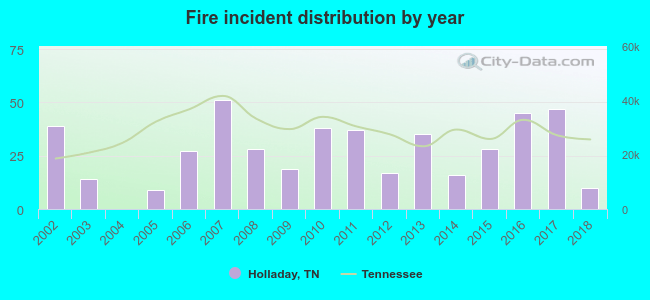 Based on the data from the years 2002 - 2018 the average number of fires per year is 27. The highest number of reported fires - 51 took place in 2007, and the least - 0 in 2004. The data has a declining trend.
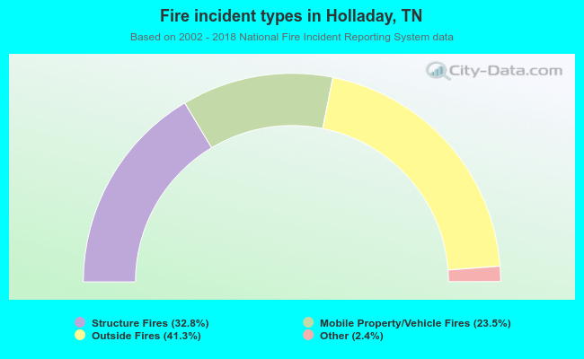 When looking into fire subcategories, the most reports belonged to: Outside Fires (41.3%), and Structure Fires (32.8%).
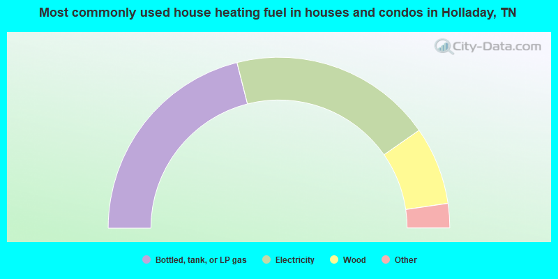
- 42.1%Bottled, tank, or LP gas
- 38.5%Electricity
- 14.8%Wood
- 3.7%Utility gas
- 0.9%Fuel oil, kerosene, etc.
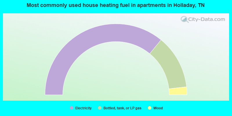
- 71.8%Electricity
- 24.5%Bottled, tank, or LP gas
- 3.6%Wood
Holladay compared to Tennessee state average:
- Median house value significantly below state average.
- Unemployed percentage below state average.
- Black race population percentage significantly below state average.
- Hispanic race population percentage significantly below state average.
- Foreign-born population percentage significantly below state average.
- Renting percentage significantly below state average.
- Length of stay since moving in significantly above state average.
- Number of rooms per house significantly below state average.
- House age significantly below state average.
- Number of college students significantly below state average.
- Percentage of population with a bachelor's degree or higher significantly below state average.

|
Total of 1 patent application in 2008-2024.