Harmony, Tennessee
Submit your own pictures of this place and show them to the world
- OSM Map
- General Map
- Google Map
- MSN Map

| Males: 1,408 | |
| Females: 1,431 |
| Median resident age: | 37.7 years |
| Tennessee median age: | 35.9 years |
Zip code: 37306
| Harmony: | $64,102 |
| TN: | $65,254 |
Estimated per capita income in 2022: $33,874 (it was $19,056 in 2000)
Harmony CCD income, earnings, and wages data
Estimated median house or condo value in 2022: $243,739 (it was $82,800 in 2000)
| Harmony: | $243,739 |
| TN: | $284,800 |
Detailed information about poverty and poor residents in Harmony, TN
Compare current foreclosures near Harmony, TN:
| Photo | Address | Area | Beds / Baths | Price | Details |
|---|---|---|---|---|---|

|
#1
Jackson St
Cowan, TN 37318
|
1,314 sq. feet
|
2 baths 4 beds |
show details | |

|
#2
Lynchburg Hwy
Fayetteville, TN 37334
|
2,444 sq. feet
|
3 baths 3 beds |
show details | |

|
#3
N West St
Decherd, TN 37324
|
2,528 sq. feet
|
2 baths 3 beds |
show details | |

|
#4
N Collins St
Tullahoma, TN 37388
|
1,064 sq. feet
|
1 baths 2 beds |
show details | |

|
#5
Westwood Ln
Estill Springs, TN 37330
|
1,664 sq. feet
|
1 baths 3 beds |
show details | |

|
#6
Sunset Vw
Estill Springs, TN 37330
|
1,325 sq. feet
|
1 baths - beds |
show details | |

|
#7
W Market St
Decherd, TN 37324
|
1,100 sq. feet
|
1 baths - beds |
show details | |

|
#8
Red Hawk Ln
Winchester, TN 37398
|
1,176 sq. feet
|
1 baths - beds |
show details | |

|
#9
Steelman Rd
Mulberry, TN 37359
|
2,100 sq. feet
|
2 baths - beds |
show details | |

|
#10
Westlake Pl
Tullahoma, TN 37388
|
992 sq. feet
|
1 baths - beds |
show details |
| Photo | Address | Area | Beds / Baths | Price | Details |
|---|---|---|---|---|---|

|
#11
Brighton Rd
Flintville, TN 37335
|
1,025 sq. feet
|
1 baths - beds |
show details | |

|
#12
Linda Ln
Tullahoma, TN 37388
|
1,706 sq. feet
|
2 baths - beds |
show details | |

|
#13
Westside Dr
Tullahoma, TN 37388
|
1,248 sq. feet
|
1 baths - beds |
show details | |

|
#14
Mechanic St N
Lynchburg, TN 37352
|
2,552 sq. feet
|
2 baths - beds |
show details | |

|
#15
Main St
Lynchburg, TN 37352
|
1,396 sq. feet
|
1 baths - beds |
show details | |

|
#16
Turkey Creek Run
Tullahoma, TN 37388
|
888 sq. feet
|
1 baths - beds |
show details | |

|
#17
Roys Ln
Winchester, TN 37398
|
1,300 sq. feet
|
2 baths - beds |
show details | |

|
#18
Swift Ln
Tullahoma, TN 37388
|
1,196 sq. feet
|
2 baths - beds |
show details | |

|
#19
Jean Dr
Tullahoma, TN 37388
|
1,268 sq. feet
|
2 baths - beds |
show details | |

|
#20
Pleasant Hill Rd
Lynchburg, TN 37352
|
3,150 sq. feet
|
2 baths - beds |
show details |
| Photo | Address | Area | Beds / Baths | Price | Details |
|---|---|---|---|---|---|

|
#21
Spring St
Decherd, TN 37324
|
1,480 sq. feet
|
1 baths - beds |
show details | |

|
#22
Powell St
Decherd, TN 37324
|
1,064 sq. feet
|
2 baths - beds |
show details | |

|
#23
Twerp Trl
Estill Springs, TN 37330
|
1,129 sq. feet
|
2 baths - beds |
show details | |

|
#24
N 2nd St
Decherd, TN 37324
|
1,340 sq. feet
|
1 baths - beds |
show details | |

|
#25
Howell Hill Rd
Flintville, TN 37335
|
1,269 sq. feet
|
1 baths - beds |
show details | |

|
#26
Old Estill Springs Rd
Tullahoma, TN 37388
|
1,300 sq. feet
|
1 baths - beds |
show details | |

|
#27
Skyview Ln
Tullahoma, TN 37388
|
1,466 sq. feet
|
2 baths - beds |
show details | |

|
#28
Echols Rd
Elora, TN 37328
|
1,807 sq. feet
|
2 baths - beds |
show details | |

|
#29
N Jackson St
Normandy, TN 37360
|
1,269 sq. feet
|
1 baths - beds |
show details | |

|
#30
Flowertown Rd
Normandy, TN 37360
|
916 sq. feet
|
1 baths - beds |
show details |
| Photo | Address | Area | Beds / Baths | Price | Details |
|---|---|---|---|---|---|

|
#31
Garland Crest Ct S
Tullahoma, TN 37388
|
2,261 sq. feet
|
3 baths - beds |
show details | |

|
#32
Lynn St
Tullahoma, TN 37388
|
1,242 sq. feet
|
1 baths - beds |
show details | |

|
#33
Gimlet Rd
Fayetteville, TN 37334
|
1,680 sq. feet
|
1 baths - beds |
show details | |

|
#34
E Moore St
Tullahoma, TN 37388
|
1,152 sq. feet
|
2 baths - beds |
show details | |

|
#35
Rutledge Rd
Shelbyville, TN 37160
|
1,450 sq. feet
|
2 baths - beds |
show details | |

|
#36
N Summit St
Tullahoma, TN 37388
|
960 sq. feet
|
1 baths - beds |
show details | |

|
#37
E Warren St
Tullahoma, TN 37388
|
1,028 sq. feet
|
1 baths - beds |
show details | |

|
#38
Old Alto Hwy
Decherd, TN 37324
|
960 sq. feet
|
1 baths - beds |
show details | |

|
#39
Westwood Dr
Tullahoma, TN 37388
|
2,656 sq. feet
|
2 baths - beds |
show details | |

|
#40
Mckellar Dr
Tullahoma, TN 37388
|
1,560 sq. feet
|
2 baths - beds |
show details |
| Photo | Address | Area | Beds / Baths | Price | Details |
|---|---|---|---|---|---|

|
#41
Central Ave
Tullahoma, TN 37388
|
800 sq. feet
|
1 baths - beds |
show details | |

|
#42
Greenwood Ave
Tullahoma, TN 37388
|
1,056 sq. feet
|
1 baths - beds |
show details | |

|
#43
Cumberland Ave
Tullahoma, TN 37388
|
1,794 sq. feet
|
2 baths - beds |
show details | |

|
#44
Westwood Dr
Tullahoma, TN 37388
|
1,459 sq. feet
|
1 baths - beds |
show details | |

|
#45
Lynchburg Hwy
Lynchburg, TN 37352
|
1,392 sq. feet
|
7 baths - beds |
show details | |

|
#46
Mcgavock Pl
Tullahoma, TN 37388
|
912 sq. feet
|
1 baths - beds |
show details | |

|
#47
Crestwood Dr
Tullahoma, TN 37388
|
1,425 sq. feet
|
1 baths - beds |
show details | |

|
#48
Shasteen St
Estill Springs, TN 37330
|
1,200 sq. feet
|
1 baths - beds |
show details | |

|
#49
W Broad St
Decherd, TN 37324
|
1,568 sq. feet
|
1 baths - beds |
show details | |

|
Check over 1 million property listings on Foreclosure.com!
|
browse all offers | |||

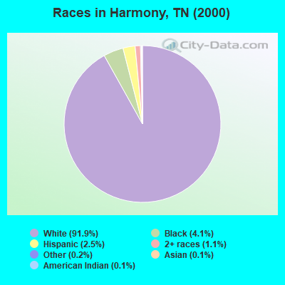
- 2,49191.9%White alone
- 1124.1%Black alone
- 672.5%Hispanic
- 291.1%Two or more races
- 50.2%Other race alone
- 30.1%American Indian alone
- 40.1%Asian alone
Races in Harmony detailed stats: ancestries, foreign born residents, place of birth
 Recent articles from our blog. Our writers, many of them Ph.D. graduates or candidates, create easy-to-read articles on a wide variety of topics.
Current Local Time: CST time zone
Land area: 53.3 square miles.
Population density: 53 people per square mile (very low).

| Harmony CCD: | 0.6% ($535) |
| Tennessee: | 0.8% ($715) |
Nearest city with pop. 50,000+: Huntsville, AL  (37.3 miles , pop. 158,216).
Nearest city with pop. 200,000+: Nashville-Davidson, TN (74.5 miles , pop. 545,524).
Nearest city with pop. 1,000,000+: Chicago, IL (468.3 miles , pop. 2,896,016).
Nearest cities:
), ), ), ), ), Latitude: 35.16 N, Longitude: 86.24 W
Area code commonly used in this area: 931


| Here: | 3.3% |
| Tennessee: | 3.0% |
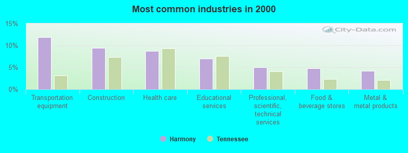
- Transportation equipment (11.9%)
- Construction (9.4%)
- Health care (8.7%)
- Educational services (6.9%)
- Professional, scientific, technical services (5.0%)
- Food & beverage stores (4.8%)
- Metal & metal products (4.2%)
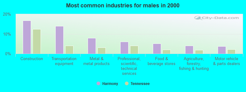
- Construction (16.7%)
- Transportation equipment (13.9%)
- Metal & metal products (7.9%)
- Professional, scientific, technical services (6.0%)
- Food & beverage stores (5.1%)
- Agriculture, forestry, fishing & hunting (4.0%)
- Motor vehicle & parts dealers (3.7%)
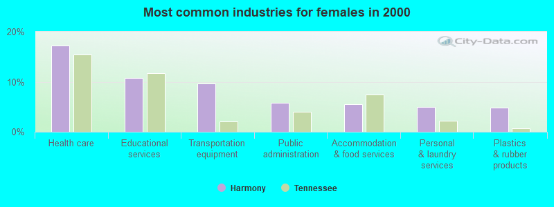
- Health care (17.2%)
- Educational services (10.7%)
- Transportation equipment (9.7%)
- Public administration (5.9%)
- Accommodation & food services (5.5%)
- Personal & laundry services (5.0%)
- Plastics & rubber products (4.8%)
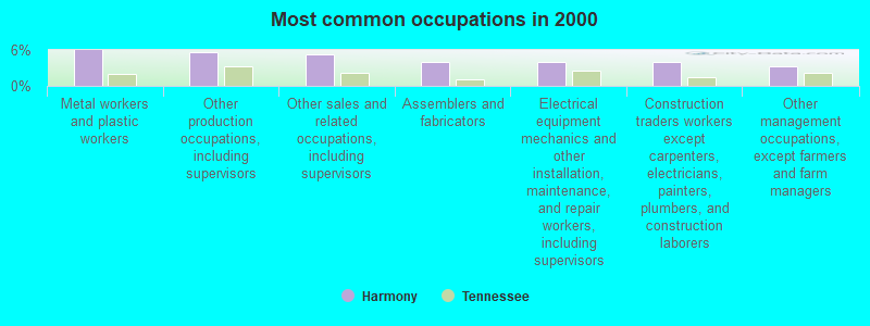
- Metal workers and plastic workers (6.0%)
- Other production occupations, including supervisors (5.5%)
- Other sales and related occupations, including supervisors (5.2%)
- Assemblers and fabricators (4.1%)
- Electrical equipment mechanics and other installation, maintenance, and repair workers, including supervisors (4.1%)
- Construction traders workers except carpenters, electricians, painters, plumbers, and construction laborers (4.0%)
- Other management occupations, except farmers and farm managers (3.3%)

- Other sales and related occupations, including supervisors (8.0%)
- Electrical equipment mechanics and other installation, maintenance, and repair workers, including supervisors (7.7%)
- Metal workers and plastic workers (6.7%)
- Construction traders workers except carpenters, electricians, painters, plumbers, and construction laborers (6.5%)
- Other management occupations, except farmers and farm managers (6.2%)
- Other production occupations, including supervisors (5.3%)
- Carpenters (4.8%)
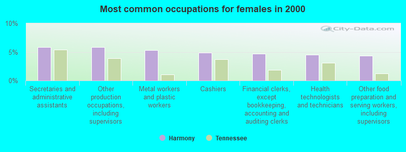
- Secretaries and administrative assistants (5.9%)
- Other production occupations, including supervisors (5.9%)
- Metal workers and plastic workers (5.3%)
- Cashiers (4.8%)
- Financial clerks, except bookkeeping, accounting and auditing clerks (4.7%)
- Health technologists and technicians (4.5%)
- Other food preparation and serving workers, including supervisors (4.3%)
Average climate in Harmony, Tennessee
Based on data reported by over 4,000 weather stations


Tornado activity:
Harmony-area historical tornado activity is above Tennessee state average. It is 102% greater than the overall U.S. average.
On 2/13/1952, a category F4 (max. wind speeds 207-260 mph) tornado 4.3 miles away from the Harmony place center killed 3 people and injured 44 people and caused between $50,000 and $500,000 in damages.
On 4/3/1974, a category F5 (max. wind speeds 261-318 mph) tornado 26.8 miles away from the place center killed 16 people and injured 190 people.
Earthquake activity:
Harmony-area historical earthquake activity is significantly above Tennessee state average. It is 156% greater than the overall U.S. average.On 4/29/2003 at 08:59:39, a magnitude 4.9 (4.4 MB, 4.6 MW, 4.9 LG, Class: Light, Intensity: IV - V) earthquake occurred 57.9 miles away from the city center
On 4/29/2003 at 08:59:39, a magnitude 4.6 (4.6 MW, Depth: 12.3 mi) earthquake occurred 57.8 miles away from Harmony center
On 4/18/2008 at 09:36:59, a magnitude 5.4 (5.1 MB, 4.8 MS, 5.4 MW, 5.2 MW, Class: Moderate, Intensity: VI - VII) earthquake occurred 245.0 miles away from Harmony center
On 1/18/1999 at 07:00:53, a magnitude 4.8 (4.8 MB, 4.0 LG, Depth: 0.6 mi) earthquake occurred 134.9 miles away from the city center
On 11/30/1973 at 07:48:41, a magnitude 4.7 (4.7 MB, 4.6 ML) earthquake occurred 135.5 miles away from Harmony center
On 4/18/2008 at 09:36:59, a magnitude 5.2 (5.2 MW, Depth: 8.9 mi) earthquake occurred 245.0 miles away from Harmony center
Magnitude types: regional Lg-wave magnitude (LG), body-wave magnitude (MB), local magnitude (ML), surface-wave magnitude (MS), moment magnitude (MW)
Natural disasters:
The number of natural disasters in Franklin County (11) is smaller than the US average (15).Major Disasters (Presidential) Declared: 8
Emergencies Declared: 2
Causes of natural disasters: Floods: 4, Storms: 4, Tornadoes: 4, Winter Storms: 3, Winds: 2, Flash Flood: 1, Heavy Rain: 1, Hurricane: 1, Ice Storm: 1, Snowfall: 1, Other: 1 (Note: some incidents may be assigned to more than one category).
Hospitals and medical centers near Harmony:
- AMEDISYS HOME CARE (Home Health Center, about 8 miles away; WINCHESTER, TN)
- WILLOWS AT WINCHESTER CARE AND REHABILITATION CENTER (Nursing Home, about 9 miles away; WINCHESTER, TN)
- SOUTHERN TENNESSEE MEDICAL CENTER Acute Care Hospitals (about 9 miles away; WINCHESTER, TN)
- GOLDEN LIVINGCENTER - MOUNTAIN VIEW (Nursing Home, about 9 miles away; WINCHESTER, TN)
- CARESOUTH HHA HOLDINGS OF WINCHESTER, LLC (Home Health Center, about 10 miles away; WINCHESTER, TN)
- RCG WINCHESTER (Dialysis Facility, about 10 miles away; WINCHESTER, TN)
- LYNCHBURG NURSING CENTER (Nursing Home, about 12 miles away; LYNCHBURG, TN)
Colleges/universities with over 2000 students nearest to Harmony:
- Motlow State Community College (about 15 miles; Tullahoma, TN; Full-time enrollment: 2,915)
- Alabama A & M University (about 33 miles; Normal, AL; FT enrollment: 4,524)
- University of Alabama in Huntsville (about 39 miles; Huntsville, AL; FT enrollment: 6,006)
- Northeast Alabama Community College (about 47 miles; Rainsville, AL; FT enrollment: 2,409)
- Middle Tennessee State University (about 48 miles; Murfreesboro, TN; FT enrollment: 21,628)
- Athens State University (about 49 miles; Athens, AL; FT enrollment: 2,771)
- John C Calhoun State Community College (about 54 miles; Tanner, AL; FT enrollment: 7,911)
Points of interest:
Notable locations in Harmony: Kaserman Switch (A), Mount Zion (B), Fairview/Devils Step Campground (C), Leatherwood Cabin Site (D), Narrows Cabin Sites (E), Cline Ridge Cabin Sites (F), Lexie Crossroads Volunteer Fire Department (G), Broadview Volunteer Fire Department (H). Display/hide their locations on the map
Churches in Harmony include: Walnut Grove United Methodist Church (A), Bethel United Methodist Church (B), Owl Hollow Church (C), Belvidere United Church of Christ (D), Harmony Cumberland Presbyterian Church (E), Lexie Cross Roads Baptist Church (F), Lexie Church of Christ (G), Burning Bush Church (H), Mount Vernon Church (I). Display/hide their locations on the map
Cemeteries: Scivally-Green Cemetery (1), Shasteen Cemetery (2), Turner Cemetery (3), Vanzant Cemetery (4), Wakefield Cemetery (5), Kaserman Cemetery (6), Young Cemetery (7). Display/hide their locations on the map
Lakes, reservoirs, and swamps: Long Pond (A), Turn Hole (B), Kings Hole (C), Mingo Pond (D), Blue Hole (E), Tims Ford Lake (F), Glaus Pond (G), Murray Lake (H). Display/hide their locations on the map
Streams, rivers, and creeks: Lost Creek (A), Collins Branch (B), Carter Branch (C), Caney Hollow Creek (D), Owl Hollow Creek (E), Boiling Fork Creek (F), Water Cure Creek (G), Neal Creek (H), Murrell Creek (I). Display/hide their locations on the map
| This place: | 2.7 people |
| Tennessee: | 2.5 people |
| This place: | 76.5% |
| Whole state: | 69.8% |
| This place: | 3.0% |
| Whole state: | 4.2% |
Likely homosexual households (counted as self-reported same-sex unmarried-partner households)
- Lesbian couples: 0.2% of all households
- Gay men: 0.4% of all households
| This place: | 7.1% |
| Whole state: | 13.5% |
| This place: | 2.0% |
| Whole state: | 5.8% |
For population 15 years and over in Harmony:

- Never married: 16.3%
- Now married: 67.8%
- Separated: 0.0%
- Widowed: 7.3%
- Divorced: 8.6%
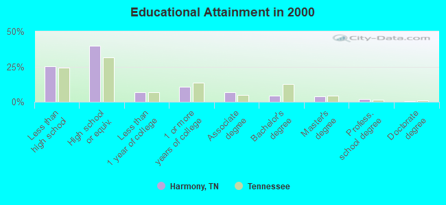
For population 25 years and over in Harmony:
- High school or higher: 74.7%
- Bachelor's degree or higher: 10.6%
- Graduate or professional degree: 6.1%
- Unemployed: 5.0%
- Mean travel time to work (commute): 29.0 minutes
| Here: | 11.5 |
| Tennessee average: | 13.3 |
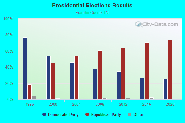
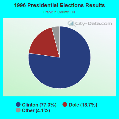

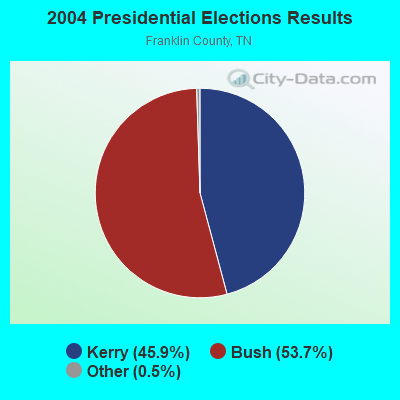
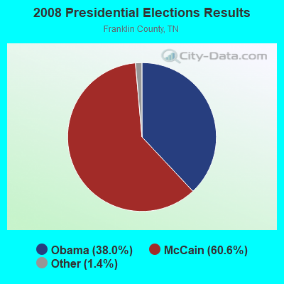

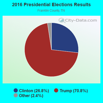

Graphs represent county-level data. Detailed 2008 Election Results
Religion statistics for Harmony, TN (based on Franklin County data)
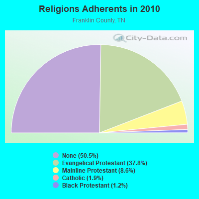
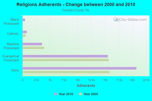
| Religion | Adherents | Congregations |
|---|---|---|
| Evangelical Protestant | 15,502 | 80 |
| Mainline Protestant | 3,525 | 20 |
| Catholic | 800 | 1 |
| Black Protestant | 480 | 4 |
| Other | 4 | 2 |
| None | 20,741 | - |
Food Environment Statistics:
| This county: | 2.68 / 10,000 pop. |
| Tennessee: | 1.99 / 10,000 pop. |
| Franklin County: | 0.24 / 10,000 pop. |
| Tennessee: | 0.17 / 10,000 pop. |
| Franklin County: | 0.73 / 10,000 pop. |
| Tennessee: | 0.65 / 10,000 pop. |
| Franklin County: | 6.57 / 10,000 pop. |
| Tennessee: | 5.16 / 10,000 pop. |
| This county: | 5.11 / 10,000 pop. |
| State: | 6.56 / 10,000 pop. |
| Franklin County: | 10.6% |
| Tennessee: | 11.4% |
| This county: | 30.1% |
| Tennessee: | 30.2% |
| Franklin County: | 14.9% |
| Tennessee: | 13.5% |
Strongest AM radio stations in Harmony:
- WWAM (820 AM; daytime; 50 kW; JASPER, TN; Owner: SHELTON BROADCASTING SYSTEM)
- WLOR (1550 AM; 50 kW; HUNTSVILLE, AL; Owner: BCA RADIO, LLC)
- WZYX (1440 AM; 5 kW; COWAN, TN; Owner: TIMS FORD BROADCASTING COMPANY, INC.)
- WFLI (1070 AM; 50 kW; LOOKOUT MOUNTAIN, TN; Owner: WFLI, INC.)
- WBXR (1140 AM; daytime; 15 kW; HAZEL GREEN, AL; Owner: LOW COUNTRY CORPORATION, INC.)
- WSM (650 AM; 50 kW; NASHVILLE, TN; Owner: GAYLORD ENTERTAINMENT COMPANY)
- WCDT (1340 AM; 1 kW; WINCHESTER, TN; Owner: FRANKLIN COUNTY RADIO & B/CTING, INC)
- WAMB (1160 AM; 50 kW; DONELSON, TN; Owner: GREAT SOUTHERN BROADCASTING COMPANY, INC.)
- WDJL (1000 AM; daytime; 10 kW; HUNTSVILLE, AL; Owner: JAMES K. SHARP DBA 5TH AVE BROADCASTING)
- WMSR (1320 AM; 5 kW; MANCHESTER, TN; Owner: COFFEE COUNTY BROADCASTING, INC.)
- WNSI (810 AM; 50 kW; JACKSONVILLE, AL; Owner: UNITED BROADCASTING NETWORK, INC.)
- WKDA (1200 AM; 50 kW; NASHVILLE, TN; Owner: RADIO NASHVILLE, INC.)
- WVNN (770 AM; 10 kW; ATHENS, AL; Owner: ATHENS BROADCASTING COMPANY, INC.)
Strongest FM radio stations in Harmony:
- WUSX (93.3 FM; TULLAHOMA, TN; Owner: TENNNESSE VALLEY RADIO, INC)
- WAHR (99.1 FM; HUNTSVILLE, AL; Owner: BCA RADIO, LLC)
- WWTN (99.7 FM; MANCHESTER, TN; Owner: CUMULUS LICENSING CORP.)
- W289AC (105.7 FM; HUNTSVILLE, AL; Owner: WILLIAM PAXTON ROGERS)
- WXQW (94.1 FM; MERIDIANVILLE, AL; Owner: CAPSTAR TX LIMITED PARTNERSHIP)
- W293AH (106.5 FM; NORMAL, AL; Owner: CAPSTAR TX LIMITED PARTNERSHIP)
- WYTM-FM (105.5 FM; FAYETTEVILLE, TN; Owner: TIME BROADCASTERS, INC.)
- WZYP (104.3 FM; ATHENS, AL; Owner: ATHENS BROADCASTING COMPANY, INC.)
- W249BB (97.7 FM; HUNTSVILLE, AL; Owner: WAY-FM MEDIA GROUP, INC.)
- W275AA (102.9 FM; HUNTSVILLE, AL; Owner: ARCHIE C. BOBO, PERSONAL REP. OF DORSEY E. NEWMAN ESTATE)
- W300AH (107.9 FM; HUNTSVILLE, AL; Owner: PORTER L. BATTS)
- W278AA (103.5 FM; MADISON, AL; Owner: TENNESSEE VALLEY RADIO, INC.)
- W202BV (88.3 FM; HUNTSVILLE, AL; Owner: WAY-FM MEDIA GROUP, INC.)
- W222AK (92.3 FM; HUNTSVILLE, AL; Owner: PRESS W. PARHAM)
- WUSY (100.7 FM; CLEVELAND, TN; Owner: CAPSTAR TX LIMITED PARTNERSHIP)
- WMXF-FM (97.3 FM; SOUTH PITTSBURG, TN; Owner: CAPSTAR TX LIMITED PARTNERSHIP)
- WMBW (88.9 FM; CHATTANOOGA, TN; Owner: THE MOODY BIBLE INSTITUTE OF CHICAGO)
- WDRM (102.1 FM; DECATUR, AL; Owner: CAPSTAR TX LIMITED PARTNERSHIP)
- WFTZ (101.5 FM; MANCHESTER, TN; Owner: PHASE TWO COMMUNICATIONS, INC.)
- WRTT-FM (95.1 FM; HUNTSVILLE, AL; Owner: BCA RADIO, LLC)
TV broadcast stations around Harmony:
- WFLI-TV (Channel 53; CLEVELAND, TN; Owner: CHATTANOOGA MEDIA HOLDINGS, L.L.C.)
- WZDX (Channel 54; HUNTSVILLE, AL; Owner: HUNTSVILLE TELEVISION ACQUISITION CORP.)
- WAAY-TV (Channel 31; HUNTSVILLE, AL; Owner: PIEDMONT TELEVISION OF HUNTSVILLE LICENSE LLC)
- WHNT-TV (Channel 19; HUNTSVILLE, AL; Owner: NEW YORK TIMES MANAGEMENT SERVICES)

- 54.1%Electricity
- 42.8%Bottled, tank, or LP gas
- 1.5%Wood
- 0.8%Utility gas
- 0.8%Fuel oil, kerosene, etc.
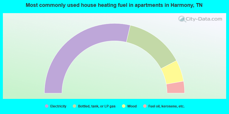
- 57.3%Electricity
- 27.3%Bottled, tank, or LP gas
- 10.0%Wood
- 5.5%Fuel oil, kerosene, etc.
Harmony compared to Tennessee state average:
- Unemployed percentage below state average.
- Black race population percentage significantly below state average.
- Hispanic race population percentage below state average.
- Foreign-born population percentage significantly below state average.
- Renting percentage significantly below state average.
- Length of stay since moving in significantly above state average.
- Number of rooms per house significantly below state average.
- House age significantly below state average.
- Percentage of population with a bachelor's degree or higher below state average.