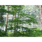
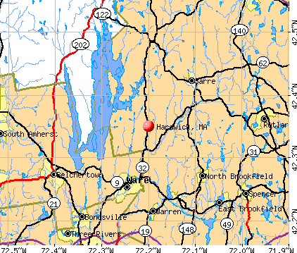
Hardwick, Massachusetts
Submit your own pictures of this town and show them to the world
- OSM Map
- General Map
- Google Map
- MSN Map
Population change since 2000: +14.0%
 |
| Males: 1,501 | |
| Females: 1,489 |
| Median resident age: | 39.7 years |
| Massachusetts median age: | 39.2 years |
Zip codes: 01031.
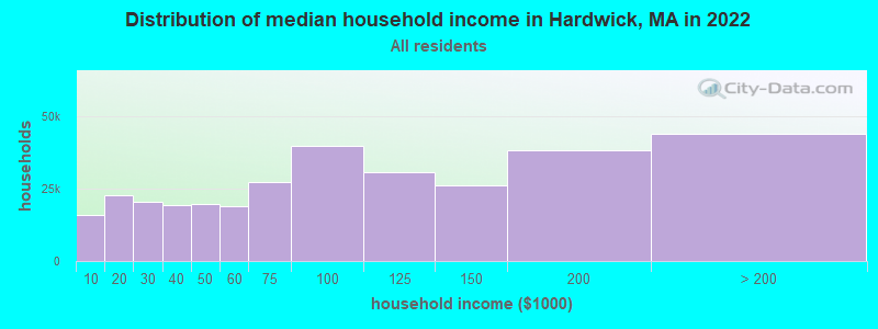
| Hardwick: | $82,417 |
| MA: | $94,488 |
Estimated per capita income in 2022: $40,602 (it was $20,824 in 2000)
Hardwick town income, earnings, and wages data
Estimated median house or condo value in 2022: $359,004 (it was $130,000 in 2000)
| Hardwick: | $359,004 |
| MA: | $534,700 |
Mean prices in 2022: all housing units: $419,164; detached houses: $447,621; townhouses or other attached units: $343,592; in 2-unit structures: $323,295; in 3-to-4-unit structures: $332,295; in 5-or-more-unit structures: $232,758; mobile homes: $113,885
Detailed information about poverty and poor residents in Hardwick, MA
Compare current foreclosures near Hardwick, MA:
| Photo | Address | Area | Beds / Baths | Price | Details |
|---|---|---|---|---|---|

|
#1
Hardwick Road
Hardwick, MA 01037
|
- sq. feet
|
1 baths 3 beds |
$229,900
|
show details |

|
#2
N Brookfield Rd
Oakham, MA 01068
|
1,078 sq. feet
|
1 baths 2 beds |
$439,900
|
show details |

|
#3
Main St # 3144
Palmer, MA 01069
|
875 sq. feet
|
1 baths 2 beds |
show details | |

|
#4
Brickyard Rd
Athol, MA 01331
|
1,685 sq. feet
|
2 baths 4 beds |
show details | |

|
#5
Brookfield Rd
Brimfield, MA 01010
|
1,482 sq. feet
|
3 baths 3 beds |
show details | |

|
#6
Nelson Street
Warren, MA 01083
|
- sq. feet
|
2 baths 3 beds |
show details | |

|
#7
Stone Rd
Orange, MA 01364
|
1,312 sq. feet
|
1 baths 3 beds |
show details | |

|
#8
Treadwell Ter
Spencer, MA 01562
|
960 sq. feet
|
1 baths 3 beds |
show details | |

|
#9
Hovey Rd
Monson, MA 01057
|
2,256 sq. feet
|
1 baths 4 beds |
show details | |

|
#10
Patriots Rd
Templeton, MA 01468
|
972 sq. feet
|
1 baths 2 beds |
show details |
| Photo | Address | Area | Beds / Baths | Price | Details |
|---|---|---|---|---|---|

|
#11
Belchertown St
Three Rivers, MA 01080
|
1,304 sq. feet
|
1 baths 3 beds |
show details | |

|
#12
Bryant St
Athol, MA 01331
|
975 sq. feet
|
2 baths 3 beds |
show details | |

|
#13
Main St
Palmer, MA 01069
|
1,114 sq. feet
|
2 baths 2 beds |
show details | |

|
#14
Warebrook Vlg
Ware, MA 01082
|
1,344 sq. feet
|
2 baths 3 beds |
show details | |

|
#15
Sanders St
Athol, MA 01331
|
2,185 sq. feet
|
2 baths 4 beds |
show details | |

|
#16
S Main St
Palmer, MA 01069
|
1,117 sq. feet
|
2 baths 2 beds |
show details | |

|
#17
Washington St
Warren, MA 01083
|
1,864 sq. feet
|
2 baths 3 beds |
show details | |

|
#18
Hapgood St
Athol, MA 01331
|
1,344 sq. feet
|
3 baths 3 beds |
show details | |

|
#19
Lane Rd
Barre, MA 01005
|
2,346 sq. feet
|
2 baths 2 beds |
show details | |

|
#20
S Main St
Athol, MA 01331
|
1,805 sq. feet
|
2 baths 2 beds |
show details |
| Photo | Address | Area | Beds / Baths | Price | Details |
|---|---|---|---|---|---|

|
#21
Leverett Rd
Shutesbury, MA 01072
|
1,131 sq. feet
|
1 baths 3 beds |
show details | |

|
#22
Miller St
Ludlow, MA 01056
|
1,657 sq. feet
|
2 baths 3 beds |
show details | |

|
#23
Stebbins St
Belchertown, MA 01007
|
1,011 sq. feet
|
1 baths 3 beds |
show details | |

|
#24
Grove St
Ware, MA 01082
|
1,386 sq. feet
|
3 baths 3 beds |
show details | |

|
#25
Healdville Rd
Hubbardston, MA 01452
|
936 sq. feet
|
1 baths 2 beds |
show details | |

|
#26
Quaboag St
Three Rivers, MA 01080
|
792 sq. feet
|
1 baths 2 beds |
show details | |

|
#27
Longview St
Palmer, MA 01069
|
2,474 sq. feet
|
3 baths 3 beds |
show details | |

|
#28
Hardwick Rd
Gilbertville, MA 01031
|
1,356 sq. feet
|
1 baths 3 beds |
show details | |

|
#29
Chauncey Walker St
Belchertown, MA 01007
|
1,768 sq. feet
|
1 baths 3 beds |
show details | |

|
#30
Flynt St
Palmer, MA 01069
|
1,200 sq. feet
|
1 baths 3 beds |
show details |
| Photo | Address | Area | Beds / Baths | Price | Details |
|---|---|---|---|---|---|

|
#31
Norma St
Palmer, MA 01069
|
1,144 sq. feet
|
1 baths 3 beds |
show details | |

|
#32
New Boston Rd
Sturbridge, MA 01566
|
2,608 sq. feet
|
2 baths 4 beds |
show details | |

|
#33
New Boston Rd
Sturbridge, MA 01566
|
2,608 sq. feet
|
2 baths 4 beds |
show details | |

|
#34
Wildflower Dr
Amherst, MA 01002
|
2,330 sq. feet
|
2 baths 4 beds |
show details | |

|
#35
Maplecrest Dr
Belchertown, MA 01007
|
1,685 sq. feet
|
2 baths 4 beds |
show details | |

|
#36
Britney Dr
Rutland, MA 01543
|
1,672 sq. feet
|
1 baths 3 beds |
show details | |

|
#37
Holbrook Ln
Paxton, MA 01612
|
1,600 sq. feet
|
2 baths 3 beds |
show details | |

|
#38
Pleasant St
Three Rivers, MA 01080
|
1,127 sq. feet
|
1 baths 4 beds |
show details | |

|
#39
East St
Three Rivers, MA 01080
|
1,524 sq. feet
|
1 baths 2 beds |
show details | |

|
#40
Lyford Rd
Spencer, MA 01562
|
2,014 sq. feet
|
2 baths 2 beds |
show details |
| Photo | Address | Area | Beds / Baths | Price | Details |
|---|---|---|---|---|---|

|
#41
Briggs Rd
Shutesbury, MA 01072
|
1,434 sq. feet
|
1 baths 3 beds |
show details | |

|
#42
Riceville Rd
Athol, MA 01331
|
1,304 sq. feet
|
2 baths 3 beds |
show details | |

|
#43
Breckenridge St
Palmer, MA 01069
|
808 sq. feet
|
1 baths 2 beds |
show details | |

|
#44
Oakridge Dr
Rutland, MA 01543
|
1,190 sq. feet
|
1 baths 3 beds |
show details | |

|
#45
Overlook Dr
Three Rivers, MA 01080
|
1,058 sq. feet
|
1 baths 3 beds |
show details | |

|
#46
White Pond Rd
Athol, MA 01331
|
2,340 sq. feet
|
2 baths 5 beds |
show details | |

|
#47
Helen Ln
Belchertown, MA 01007
|
2,567 sq. feet
|
2 baths 4 beds |
show details | |

|
#48
Main St
Three Rivers, MA 01080
|
927 sq. feet
|
1 baths 3 beds |
show details | |

|
#49
Ruggles Ct
Three Rivers, MA 01080
|
1,008 sq. feet
|
1 baths 1 beds |
show details | |

|
Check over 1 million property listings on Foreclosure.com!
|
browse all offers | |||

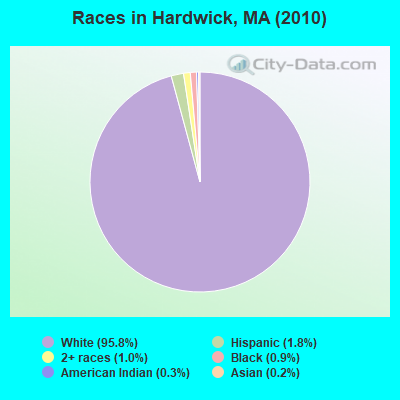
- 2,86595.8%White alone
- 531.8%Hispanic
- 291.0%Two or more races
- 270.9%Black alone
- 80.3%American Indian alone
- 60.2%Asian alone
- 20.07%Native Hawaiian and Other
Pacific Islander alone
Races in Hardwick detailed stats: ancestries, foreign born residents, place of birth
According to our research of Massachusetts and other state lists, there was 1 registered sex offender living in Hardwick, Massachusetts as of June 03, 2024.
The ratio of all residents to sex offenders in Hardwick is 2,990 to 1.
The ratio of registered sex offenders to all residents in this city is lower than the state average.
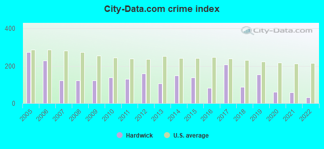
Type |
2009 |
2010 |
2011 |
2012 |
2013 |
2014 |
2015 |
2016 |
2017 |
2018 |
2019 |
2020 |
2021 |
2022 |
|---|---|---|---|---|---|---|---|---|---|---|---|---|---|---|
| Murders (per 100,000) | 0 (0.0) | 0 (0.0) | 0 (0.0) | 0 (0.0) | 0 (0.0) | 0 (0.0) | 0 (0.0) | 0 (0.0) | 0 (0.0) | 0 (0.0) | 0 (0.0) | 0 (0.0) | 0 (0.0) | 0 (0.0) |
| Rapes (per 100,000) | 0 (0.0) | 0 (0.0) | 0 (0.0) | 0 (0.0) | 1 (33.3) | 1 (33.2) | 0 (0.0) | 1 (24.9) | 3 (74.4) | 0 (0.0) | 2 (65.8) | 0 (0.0) | 0 (0.0) | 0 (0.0) |
| Robberies (per 100,000) | 1 (37.4) | 0 (0.0) | 0 (0.0) | 0 (0.0) | 0 (0.0) | 0 (0.0) | 0 (0.0) | 0 (0.0) | 0 (0.0) | 0 (0.0) | 0 (0.0) | 1 (32.8) | 0 (0.0) | 0 (0.0) |
| Assaults (per 100,000) | 6 (224.5) | 12 (401.3) | 8 (266.0) | 11 (363.4) | 4 (133.1) | 8 (266.0) | 11 (364.7) | 4 (99.5) | 21 (521.0) | 6 (198.1) | 12 (394.9) | 6 (196.9) | 8 (260.0) | 4 (149.7) |
| Burglaries (per 100,000) | 8 (299.3) | 11 (367.9) | 12 (398.9) | 8 (264.3) | 8 (266.2) | 8 (266.0) | 13 (431.0) | 9 (223.9) | 9 (223.3) | 6 (198.1) | 4 (131.6) | 1 (32.8) | 1 (32.5) | 0 (0.0) |
| Thefts (per 100,000) | 27 (1,010) | 25 (836.1) | 37 (1,230) | 43 (1,421) | 20 (665.6) | 29 (964.1) | 23 (762.6) | 24 (597.2) | 25 (620.2) | 23 (759.3) | 11 (362.0) | 1 (32.8) | 3 (97.5) | 2 (74.9) |
| Auto thefts (per 100,000) | 2 (74.8) | 0 (0.0) | 0 (0.0) | 4 (132.1) | 3 (99.8) | 4 (133.0) | 2 (66.3) | 2 (49.8) | 1 (24.8) | 2 (66.0) | 0 (0.0) | 3 (98.5) | 0 (0.0) | 0 (0.0) |
| Arson (per 100,000) | 4 (149.6) | 2 (66.9) | 2 (66.5) | 0 (0.0) | 0 (0.0) | 0 (0.0) | 2 (66.3) | 0 (0.0) | 0 (0.0) | 0 (0.0) | 0 (0.0) | 1 (32.8) | 0 (0.0) | 0 (0.0) |
| City-Data.com crime index | 123.5 | 139.5 | 130.3 | 158.6 | 106.5 | 147.6 | 138.9 | 83.4 | 206.2 | 89.1 | 155.3 | 60.7 | 58.2 | 32.9 |
The City-Data.com crime index weighs serious crimes and violent crimes more heavily. Higher means more crime, U.S. average is 246.1. It adjusts for the number of visitors and daily workers commuting into cities.
Crime rate in Hardwick detailed stats: murders, rapes, robberies, assaults, burglaries, thefts, arson
Full-time law enforcement employees in 2021, including police officers: 6 (6 officers - 6 male; 0 female).
| Officers per 1,000 residents here: | 1.95 |
| Massachusetts average: | 2.53 |
 Recent articles from our blog. Our writers, many of them Ph.D. graduates or candidates, create easy-to-read articles on a wide variety of topics.

 | Acton or…? (77 replies) |
| Hillbilly Massachusetts (103 replies) |
| Moderate towns with 95 (50 replies) |
| Towns in Boston MSA, but many might think not (44 replies) |
| Catskills Like Towns in Mass? (52 replies) |
| Town in Massachusetts You’d Least Like To Live In? (179 replies) |
Latest news from Hardwick, MA collected exclusively by city-data.com from local newspapers, TV, and radio stations
Ancestries: French (18.7%), Irish (18.3%), Polish (17.2%), English (15.1%), French Canadian (8.3%), German (7.6%).
Current Local Time: EST time zone
Incorporated in 1739
Elevation: 880 feet
Land area: 38.6 square miles.
Population density: 77 people per square mile (very low).
76 residents are foreign born (1.5% Europe, 0.6% North America, 0.4% Africa).
| This town: | 2.9% |
| Massachusetts: | 12.2% |
| Hardwick town: | 1.4% ($1,810) |
| Massachusetts: | 1.3% ($2,336) |
Nearest city with pop. 50,000+: Worcester, MA  (21.0 miles , pop. 172,648).
Nearest city with pop. 200,000+: Boston, MA (56.8 miles , pop. 589,141).
Nearest city with pop. 1,000,000+: Bronx, NY (135.2 miles , pop. 1,332,650).
Nearest cities:
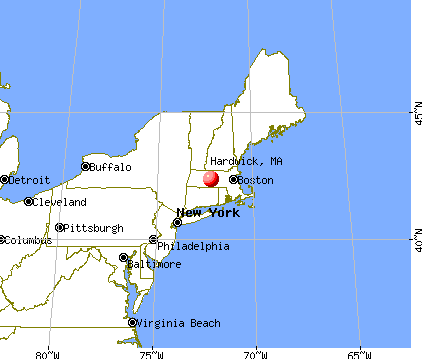
), Latitude: 42.35 N, Longitude: 72.20 W

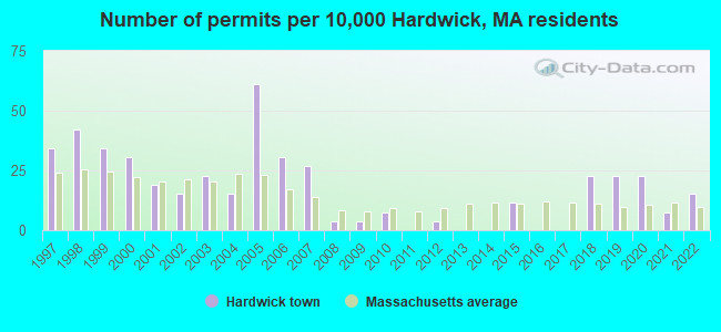
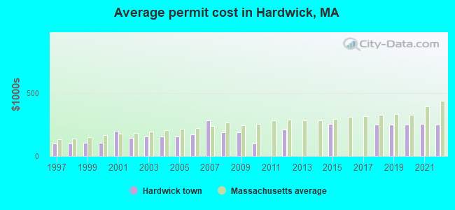
Single-family new house construction building permits:
- 2022: 4 buildings, average cost: $251,200
- 2021: 2 buildings, average cost: $251,500
- 2020: 6 buildings, average cost: $250,900
- 2019: 6 buildings, average cost: $250,900
- 2018: 6 buildings, average cost: $250,900
- 2015: 3 buildings, average cost: $257,200
- 2012: 1 building, cost: $210,000
- 2010: 2 buildings, average cost: $98,800
- 2009: 1 building, cost: $190,000
- 2008: 1 building, cost: $190,000
- 2007: 7 buildings, average cost: $282,600
- 2006: 8 buildings, average cost: $169,900
- 2005: 16 buildings, average cost: $153,700
- 2004: 4 buildings, average cost: $152,800
- 2003: 6 buildings, average cost: $154,900
- 2002: 4 buildings, average cost: $146,400
- 2001: 5 buildings, average cost: $197,600
- 2000: 8 buildings, average cost: $102,700
- 1999: 9 buildings, average cost: $105,600
- 1998: 11 buildings, average cost: $97,100
- 1997: 9 buildings, average cost: $101,900
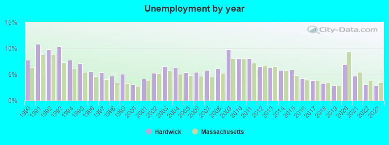
| Here: | 2.9% |
| Massachusetts: | 3.5% |
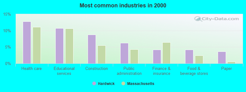
- Health care (12.8%)
- Educational services (10.8%)
- Construction (8.7%)
- Public administration (6.3%)
- Finance & insurance (4.2%)
- Food & beverage stores (4.2%)
- Paper (3.6%)
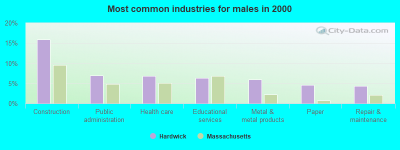
- Construction (16.0%)
- Public administration (7.0%)
- Health care (6.8%)
- Educational services (6.4%)
- Metal & metal products (5.9%)
- Paper (4.6%)
- Repair & maintenance (4.4%)
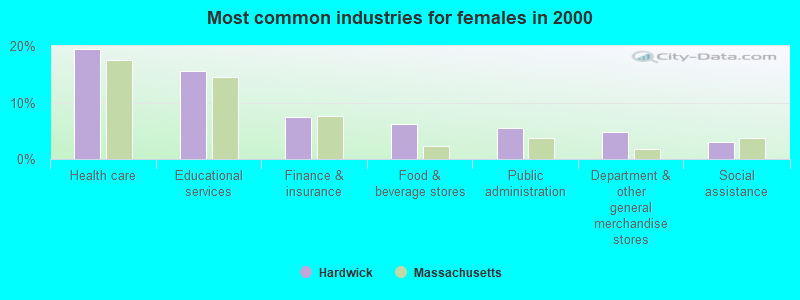
- Health care (19.4%)
- Educational services (15.6%)
- Finance & insurance (7.5%)
- Food & beverage stores (6.1%)
- Public administration (5.4%)
- Department & other general merchandise stores (4.8%)
- Social assistance (3.1%)
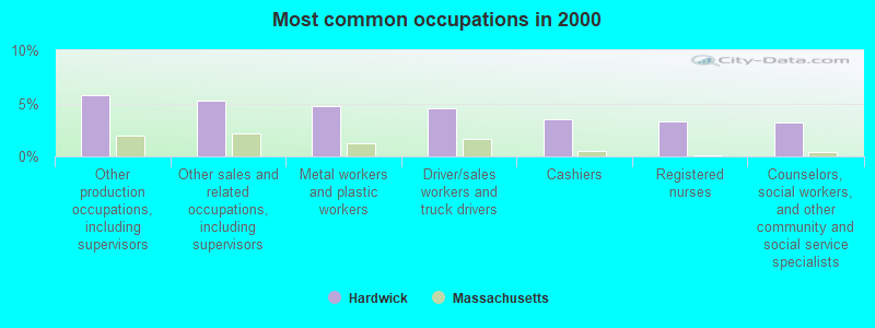
- Other production occupations, including supervisors (5.8%)
- Other sales and related occupations, including supervisors (5.2%)
- Metal workers and plastic workers (4.7%)
- Driver/sales workers and truck drivers (4.6%)
- Cashiers (3.5%)
- Registered nurses (3.3%)
- Counselors, social workers, and other community and social service specialists (3.2%)
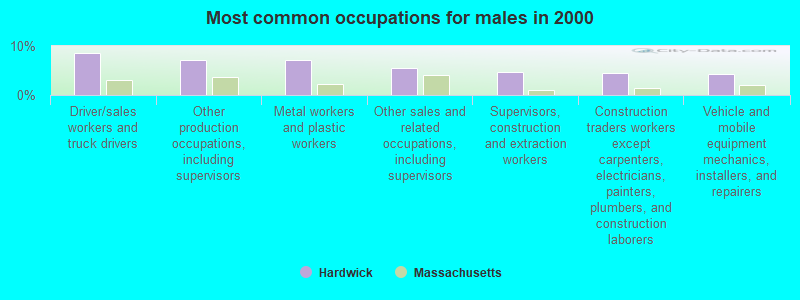
- Driver/sales workers and truck drivers (8.7%)
- Other production occupations, including supervisors (7.1%)
- Metal workers and plastic workers (7.1%)
- Other sales and related occupations, including supervisors (5.5%)
- Supervisors, construction and extraction workers (4.7%)
- Construction traders workers except carpenters, electricians, painters, plumbers, and construction laborers (4.4%)
- Vehicle and mobile equipment mechanics, installers, and repairers (4.3%)
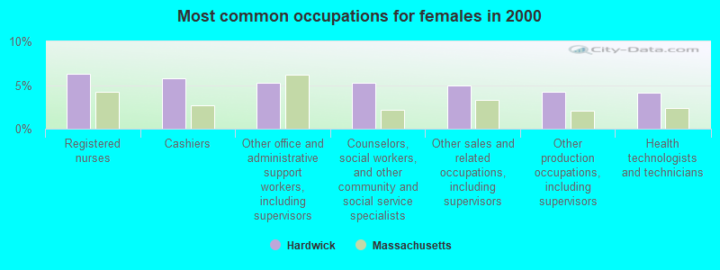
- Registered nurses (6.3%)
- Cashiers (5.8%)
- Other office and administrative support workers, including supervisors (5.3%)
- Counselors, social workers, and other community and social service specialists (5.3%)
- Other sales and related occupations, including supervisors (4.9%)
- Other production occupations, including supervisors (4.3%)
- Health technologists and technicians (4.1%)
Average climate in Hardwick, Massachusetts
Based on data reported by over 4,000 weather stations


(lower is better)
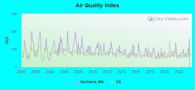
Air Quality Index (AQI) level in 2022 was 69.3. This is about average.
| City: | 69.3 |
| U.S.: | 72.6 |
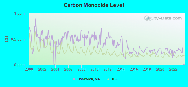
Carbon Monoxide (CO) [ppm] level in 2022 was 0.259. This is about average. Closest monitor was 20.9 miles away from the city center.
| City: | 0.259 |
| U.S.: | 0.251 |

Nitrogen Dioxide (NO2) [ppb] level in 2022 was 10.1. This is significantly worse than average. Closest monitor was 17.0 miles away from the city center.
| City: | 10.1 |
| U.S.: | 5.1 |
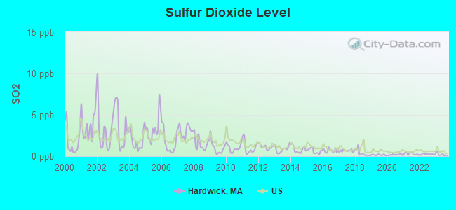
Sulfur Dioxide (SO2) [ppb] level in 2022 was 0.234. This is significantly better than average. Closest monitor was 7.7 miles away from the city center.
| City: | 0.234 |
| U.S.: | 1.515 |
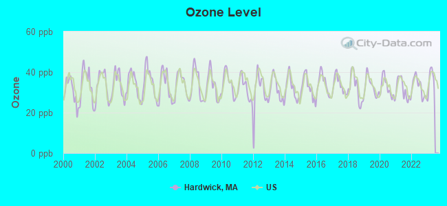
Ozone [ppb] level in 2022 was 32.7. This is about average. Closest monitor was 7.7 miles away from the city center.
| City: | 32.7 |
| U.S.: | 33.3 |
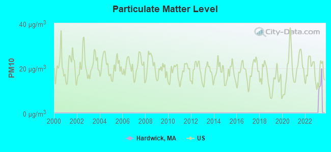
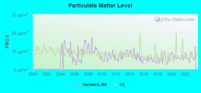
Particulate Matter (PM2.5) [µg/m3] level in 2022 was 6.81. This is about average. Closest monitor was 7.7 miles away from the city center.
| City: | 6.81 |
| U.S.: | 8.11 |
Tornado activity:
Hardwick-area historical tornado activity is above Massachusetts state average. It is 10% smaller than the overall U.S. average.
On 6/9/1953, a category F4 (max. wind speeds 207-260 mph) tornado 8.5 miles away from the Hardwick town center killed 90 people and injured 1228 people and caused between $50,000,000 and $500,000,000 in damages.
On 10/3/1970, a category F3 (max. wind speeds 158-206 mph) tornado 2.0 miles away from the town center killed one person and caused between $50,000 and $500,000 in damages.
Earthquake activity:
Hardwick-area historical earthquake activity is significantly above Massachusetts state average. It is 71% smaller than the overall U.S. average.On 10/7/1983 at 10:18:46, a magnitude 5.3 (5.1 MB, 5.3 LG, 5.1 ML, Class: Moderate, Intensity: VI - VII) earthquake occurred 154.9 miles away from Hardwick center
On 4/20/2002 at 10:50:47, a magnitude 5.3 (5.3 ML, Depth: 3.0 mi) earthquake occurred 167.5 miles away from the city center
On 4/20/2002 at 10:50:47, a magnitude 5.2 (5.2 MB, 4.2 MS, 5.2 MW, 5.0 MW) earthquake occurred 166.4 miles away from the city center
On 1/19/1982 at 00:14:42, a magnitude 4.7 (4.5 MB, 4.7 MD, 4.5 LG, Class: Light, Intensity: IV - V) earthquake occurred 85.2 miles away from the city center
On 10/16/2012 at 23:12:25, a magnitude 4.7 (4.7 ML, Depth: 10.0 mi) earthquake occurred 116.4 miles away from Hardwick center
On 10/2/1994 at 11:27:22, a magnitude 3.7 (3.5 LG, 3.7 LG, Depth: 6.2 mi, Class: Light, Intensity: II - III) earthquake occurred 4.0 miles away from the city center
Magnitude types: regional Lg-wave magnitude (LG), body-wave magnitude (MB), duration magnitude (MD), local magnitude (ML), surface-wave magnitude (MS), moment magnitude (MW)
Natural disasters:
The number of natural disasters in Worcester County (27) is a lot greater than the US average (15).Major Disasters (Presidential) Declared: 15
Emergencies Declared: 12
Causes of natural disasters: Floods: 9, Storms: 8, Hurricanes: 6, Snowstorms: 5, Winter Storms: 4, Blizzards: 2, Snows: 2, Fire: 1, Heavy Rain: 1, Snowfall: 1, Tornado: 1, Wind: 1 (Note: some incidents may be assigned to more than one category).

Hospitals and medical centers near Hardwick:
- BAYSTATE MARY LANE HOSPITAL Acute Care Hospitals (about 7 miles away; WARE, MA)
- GUARDIAN HOSPICE OF MASSACHUSETTS, INC (Hospital, about 9 miles away; WEST BROOKFIELD, MA)
- QUABOAG REHABILITATION AND SKILLED CARE CENTER (Nursing Home, about 9 miles away; WEST BROOKFIELD, MA)
- FAMILY HOME CARE, INC (Home Health Center, about 13 miles away; SPENCER, MA)
- RUTLAND HEIGHTS HOSP- SNF (Nursing Home, about 13 miles away; RUTLAND, MA)
- PALMER HEALTHCARE CENTER (Nursing Home, about 15 miles away; PALMER, MA)
- FMC DIALYSIS SERVICES OF PALMER (Dialysis Facility, about 15 miles away; PALMER, MA)
Colleges/universities with over 2000 students nearest to Hardwick:
- University of Massachusetts-Amherst (about 17 miles; Amherst, MA; Full-time enrollment: 26,583)
- Worcester State University (about 20 miles; Worcester, MA; FT enrollment: 5,426)
- Assumption College (about 20 miles; Worcester, MA; FT enrollment: 2,580)
- Mount Wachusett Community College (about 21 miles; Gardner, MA; FT enrollment: 3,143)
- Mount Holyoke College (about 21 miles; South Hadley, MA; FT enrollment: 2,573)
- Clark University (about 21 miles; Worcester, MA; FT enrollment: 3,687)
- Worcester Polytechnic Institute (about 21 miles; Worcester, MA; FT enrollment: 3,930)
Points of interest:
Notable locations in Hardwick: Hardwick Rescue and Emergency Squad (A), Hardwick Fire Department (B). Display/hide their locations on the map
Cemeteries: Taylor Cemetery (1), Saint Aloysius Cemetery (2). Display/hide their locations on the map
Lakes, reservoirs, and swamps: Dead Pond (A), Hardwick Pond (B), Hemingway Swamp (C). Display/hide their locations on the map
Streams, rivers, and creeks: Canterbury Brook (A), Broadmeadow Brook (B), Ellwell Brook (C), Fish Brook (D), Moose Brook (E), Newton Brook (F), Pine Hill Brook (G), Winimusset Brook (H). Display/hide their locations on the map
Birthplace of: Moses Robinson - Politician, Squire Whipple - Bridging engineer, Charles L. Robinson - Politician, Jonathan Robinson (American politician) - Politician, Wyman Spooner - Printer.
Drinking water stations with addresses in Hardwick and their reported violations in the past:
EAGLE HILL SCHOOL (Population served: 250, Groundwater):Past monitoring violations:
- Failure to Consult with State - In JAN-01-2014, Contaminant: GROUNDWATER RULE. Follow-up actions: St AO (w/o penalty) issued (JAN-15-2014)
- 2 regular monitoring violations
| This town: | 2.5 people |
| Massachusetts: | 2.5 people |
| This town: | 68.3% |
| Whole state: | 63.0% |
| This town: | 9.7% |
| Whole state: | 7.0% |
Likely homosexual households (counted as self-reported same-sex unmarried-partner households)
- Lesbian couples: 0.5% of all households
- Gay men: 0.3% of all households
| This town: | 7.5% |
| Whole state: | 9.3% |
| This town: | 3.7% |
| Whole state: | 4.4% |
52 people in workers' group living quarters and job corps centers in 2010
53 people in other nonhousehold living situations in 2000
7 people in nursing homes in 2000
For population 15 years and over in Hardwick:
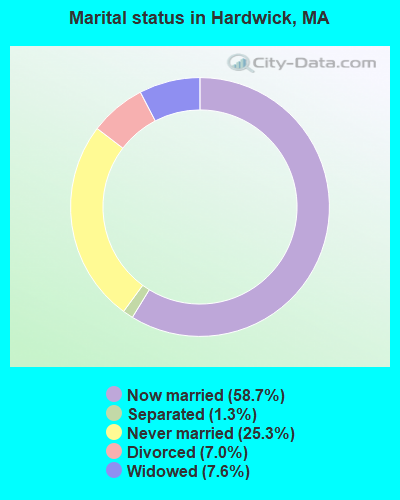
- Never married: 25.3%
- Now married: 58.7%
- Separated: 1.3%
- Widowed: 7.6%
- Divorced: 7.0%
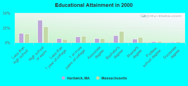
For population 25 years and over in Hardwick:
- High school or higher: 84.1%
- Bachelor's degree or higher: 21.2%
- Graduate or professional degree: 8.9%
- Unemployed: 2.7%
- Mean travel time to work (commute): 32.9 minutes

| Here: | 10.5 |
| Massachusetts average: | 13.1 |


Graphs represent county-level data. Detailed 2008 Election Results
Religion statistics for Hardwick, MA (based on Worcester County data)


| Religion | Adherents | Congregations |
|---|---|---|
| Catholic | 306,925 | 118 |
| Mainline Protestant | 43,326 | 171 |
| Evangelical Protestant | 37,511 | 203 |
| Other | 18,931 | 69 |
| Orthodox | 7,935 | 15 |
| Black Protestant | 497 | 6 |
| None | 383,427 | - |
Food Environment Statistics:
| Here: | 1.73 / 10,000 pop. |
| Massachusetts: | 1.98 / 10,000 pop. |
| This county: | 0.05 / 10,000 pop. |
| Massachusetts: | 0.05 / 10,000 pop. |
| Worcester County: | 1.79 / 10,000 pop. |
| Massachusetts: | 2.22 / 10,000 pop. |
| This county: | 2.22 / 10,000 pop. |
| Massachusetts: | 1.77 / 10,000 pop. |
| Worcester County: | 7.27 / 10,000 pop. |
| Massachusetts: | 8.76 / 10,000 pop. |
| Here: | 8.0% |
| Massachusetts: | 8.1% |
| Here: | 24.0% |
| Massachusetts: | 22.5% |
| This county: | 16.6% |
| Massachusetts: | 16.5% |
4.71% of this county's 2021 resident taxpayers lived in other counties in 2020 ($76,229 average adjusted gross income)
| Here: | 4.71% |
| Massachusetts average: | 6.35% |
0.02% of residents moved from foreign countries ($100 average AGI)
Worcester County: 0.02% Massachusetts average: 0.01%
Top counties from which taxpayers relocated into this county between 2020 and 2021:
| from Middlesex County, MA | |
| from Norfolk County, MA | |
| from Suffolk County, MA |
4.84% of this county's 2020 resident taxpayers moved to other counties in 2021 ($87,252 average adjusted gross income)
| Here: | 4.84% |
| Massachusetts average: | 7.18% |
0.03% of residents moved to foreign countries ($199 average AGI)
Worcester County: 0.03% Massachusetts average: 0.02%
Top counties to which taxpayers relocated from this county between 2020 and 2021:
| to Middlesex County, MA | |
| to Norfolk County, MA | |
| to Suffolk County, MA |
Strongest AM radio stations in Hardwick:
- WVNE (760 AM; daytime; 25 kW; LEICESTER, MA; Owner: BLOUNT MASSCOM, INC.)
- WCRN (830 AM; 50 kW; WORCESTER, MA; Owner: CARTER BROADCASTING CORPORATION)
- WNNZ (640 AM; 50 kW; WESTFIELD, MA; Owner: CLEAR CHANNEL BROADCASTING LICENSES, INC.)
- WARE (1250 AM; 5 kW; WARE, MA; Owner: SUCCESS SIGNAL BROADCASTING, INC.)
- WALE (990 AM; 50 kW; GREENVILLE, RI; Owner: NORTH AMERICAN BROADCASTING CO., INC.)
- WKOX (1200 AM; 50 kW; FRAMINGHAM, MA; Owner: CAPSTAR TX LIMITED PARTNERSHIP)
- WRKO (680 AM; 50 kW; BOSTON, MA; Owner: ENTERCOM BOSTON LICENSE, LLC)
- WEEI (850 AM; 50 kW; BOSTON, MA; Owner: ENTERCOM BOSTON LICENSE, LLC)
- WBIX (1060 AM; 40 kW; NATICK, MA; Owner: LANGER BROADCASTING CORPORATION)
- WTAG (580 AM; 5 kW; WORCESTER, MA; Owner: CAPSTAR TX LIMITED PARTNERSHIP)
- WTIC (1080 AM; 50 kW; HARTFORD, CT; Owner: INFINITY RADIO OPERATIONS INC.)
- WAMG (890 AM; 25 kW; DEDHAM, MA; Owner: MEGA COMMUNICATIONS OF DEDHAM LICENSEE, LLC)
- WPNI (1430 AM; 5 kW; AMHERST, MA; Owner: WESTERN MASSACHUSETTS RADIO COMPANY)
Strongest FM radio stations in Hardwick:
- WFCR (88.5 FM; AMHERST, MA; Owner: UNIVERSITY OF MASSACHUSETTS)
- WAAF (107.3 FM; WORCESTER, MA; Owner: ENTERCOM BOSTON LICENSE, LLC)
- WAMH (89.3 FM; AMHERST, MA; Owner: TRUSTEES OF AMHERST COLLEGE)
- WSRS (96.1 FM; WORCESTER, MA; Owner: CAPSTAR TX LIMITED PARTNERSHIP)
- W246AM (97.1 FM; AMHERST, MA; Owner: GREAT NORTHERN RADIO, LLC)
- WHYN-FM (93.1 FM; SPRINGFIELD, MA; Owner: CLEAR CHANNEL BROADCASTING LICENSES, INC.)
- WRNX (100.9 FM; AMHERST, MA; Owner: WESTERN MASSACHUSETTS RADIO COMPANY)
- WAHL (99.9 FM; ATHOL, MA; Owner: CITADEL BROADCASTING COMPANY)
- WXLO (104.5 FM; FITCHBURG, MA; Owner: CITADEL BROADCASTING COMPANY)
- WFEX (92.1 FM; PETERBOROUGH, NH; Owner: FNX BROADCASTING OF NEW HAMPSHIRE LLC)
- WAMC-FM (90.3 FM; ALBANY, NY; Owner: WAMC)
- WBPR (91.9 FM; WORCESTER, MA; Owner: UNIVERSITY OF MASSACHUSETTS)
- WAQY (102.1 FM; SPRINGFIELD, MA; Owner: SAGA COMMUNICATIONS OF NEW ENGLAND, LLC)
- WPVQ (95.3 FM; GREENFIELD, MA; Owner: GREAT NORTHERN RADIO, L.L.C.)
- WYCM (90.1 FM; CHARLTON, MA; Owner: BAY PATH VOCATIONAL HIGH SCHOOL)
- WWFX (100.1 FM; SOUTHBRIDGE, MA; Owner: CITADEL BROADCASTING COMPANY)
- WYRY (104.9 FM; HINSDALE, NH; Owner: TRI-VALLEY BROADCASTING CORPORATION)
- WORC-FM (98.9 FM; WEBSTER, MA; Owner: CITADEL BROADCASTING COMPANY)
- WHAI (98.3 FM; GREENFIELD, MA; Owner: SAGA COMMUNICATIONS OF NEW ENGLAND, LLC)
- WLZX (99.3 FM; NORTHAMPTON, MA; Owner: SAGA COMMUNICATIONS OF NEW ENGLAND, LLC)
TV broadcast stations around Hardwick:
- WYDN (Channel 48; WORCESTER, MA; Owner: EDUCATIONAL PUBLIC TV CORPORATION)
- WUNI (Channel 27; WORCESTER, MA; Owner: ENTRAVISION HOLDINGS, LLC)
- WUTF (Channel 66; MARLBOROUGH, MA; Owner: TELEFUTURA BOSTON LLC)
- WCVB-TV (Channel 5; BOSTON, MA; Owner: WCVB HEARST-ARGYLE TV, INC.)
- WGBH-TV (Channel 2; BOSTON, MA; Owner: WGBH EDUCATIONAL FOUNDATION)
- WTIC-TV (Channel 61; HARTFORD, CT; Owner: TRIBUNE TELEVISION COMPANY)
- WMFP (Channel 62; LAWRENCE, MA; Owner: WSAH LICENSE, INC.)
- WBZ-TV (Channel 4; BOSTON, MA; Owner: VIACOM INC.)
- WGBX-TV (Channel 44; BOSTON, MA; Owner: WGBH EDUCATIONAL FOUNDATION)
- WSBK-TV (Channel 38; BOSTON, MA; Owner: VIACOM INC.)
- WLVI-TV (Channel 56; CAMBRIDGE, MA; Owner: WLVI, INC.)
- WCRN-LP (Channel 34; LEICESTER, MA; Owner: CARTER BROADCASTING CORPORATION)
Medal of Honor Recipients
Medal of Honor Recipient born in Hardwick: Elmer A. Snow.
- National Bridge Inventory (NBI) Statistics
- 10Number of bridges
- 66ft / 20.2mTotal length
- $15,492,000Total costs
- 18,320Total average daily traffic
- 1,219Total average daily truck traffic
- 30,475Total future (year 2030) average daily traffic
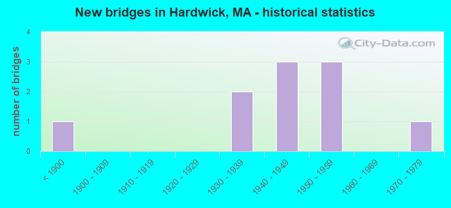
- New bridges - historical statistics
- 1Before 1900
- 21930-1939
- 31940-1949
- 31950-1959
- 11970-1979
FCC Registered Antenna Towers:
3- Chad Doherty, Thresher Rd (Lat: 42.395806 Lon: -72.196806), Type: 56.1, Structure height: 25027 m, Overall height: 54.9 m, Registrant: Towerco 2013 LLC, Cdoherty@towerco.Com, , Cary, Phone: (919) 653-5700
- Chad Doherty, Thresher Rd (Lat: 42.395806 Lon: -72.196806), Type: 56.1, Structure height: 25027 m, Overall height: 54.9 m, Registrant: Towerco 2013 LLC, Cdoherty@towerco.Com, , Cary, Phone: (919) 653-5700
- Chad Doherty, Thresher Rd (Lat: 42.395806 Lon: -72.196806), Type: 56.1, Structure height: 25027 m, Overall height: 54.9 m, Registrant: Towerco 2013 LLC, Cdoherty@towerco.Com, , Cary, Phone: (919) 653-5700
FCC Registered Broadcast Land Mobile Towers:
1- Hardwick Fire Dept (Lat: 42.353972 Lon: -72.200917), Type: Building, Structure height: 11 m, Overall height: 15 m, Call Sign: WPUL702,
Assigned Frequencies: 453.512 MHz, 453.962 MHz, Grant Date: 03/23/2012, Expiration Date: 03/28/2022, Cancellation Date: 05/28/2022, Certifier: James Owens, Registrant: Connecticut Radio, Inc, Rocky Hill, CT 06067, Phone: (860) 563-4867, Fax: (860) 563-1179
FCC Registered Amateur Radio Licenses:
10 (See the full list of FCC Registered Amateur Radio Licenses in Hardwick)2002 - 2018 National Fire Incident Reporting System (NFIRS) incidents
- Fire incident types reported to NFIRS in Hardwick, MA
- 8144.0%Outside Fires
- 7540.8%Structure Fires
- 2010.9%Other
- 84.3%Mobile Property/Vehicle Fires
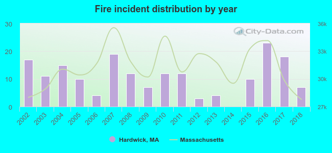 Based on the data from the years 2002 - 2018 the average number of fires per year is 11. The highest number of fire incidents - 23 took place in 2016, and the least - 0 in 2014. The data has a dropping trend.
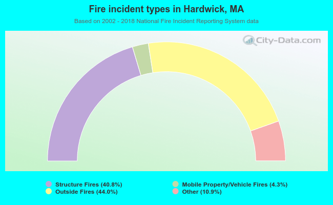 When looking into fire subcategories, the most incidents belonged to: Outside Fires (44.0%), and Structure Fires (40.8%).
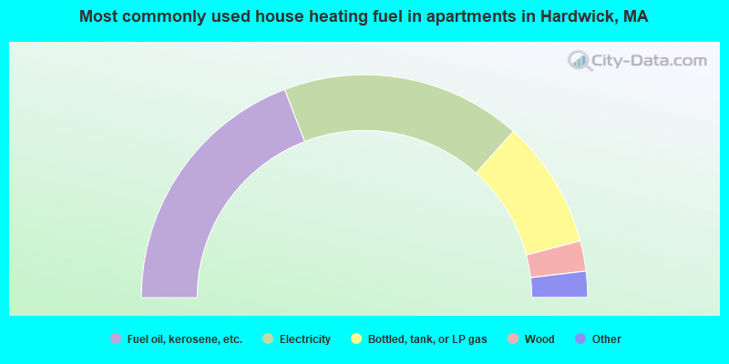
- 76.6%Fuel oil, kerosene, etc.
- 8.7%Bottled, tank, or LP gas
- 8.4%Wood
- 5.7%Electricity
- 0.6%Coal or coke
- 38.4%Fuel oil, kerosene, etc.
- 34.9%Electricity
- 18.6%Bottled, tank, or LP gas
- 4.4%Wood
- 2.5%Utility gas
- 1.3%Other fuel
Hardwick compared to Massachusetts state average:
- Unemployed percentage significantly below state average.
- Black race population percentage significantly below state average.
- Hispanic race population percentage significantly below state average.
- Foreign-born population percentage significantly below state average.
- Length of stay since moving in significantly above state average.
- Number of rooms per house significantly below state average.
- House age significantly below state average.
- Institutionalized population percentage significantly above state average.
- Number of college students below state average.
- Percentage of population with a bachelor's degree or higher below state average.
Hardwick on our top lists:
- #45 on the list of "Top 101 cities with the largest percentage of people in other nonhousehold living situations (population 1,000+)"
- #4 on the list of "Top 101 counties with the highest carbon monoxide air pollution readings in 2012 (ppm)"
- #5 on the list of "Top 101 counties with the most Catholic congregations"
- #12 on the list of "Top 101 counties with the highest surface withdrawal of fresh water for public supply"
- #16 on the list of "Top 101 counties with the highest total withdrawal of fresh water for public supply"
- #23 on the list of "Top 101 counties with the highest Sulfur Oxides Annual air pollution readings in 2012 (µg/m3)"

|
|
Total of 38 patent applications in 2008-2024.