Duxbury, Massachusetts
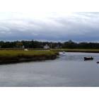
Duxbury: Marshland along the Fish River
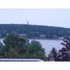
Duxbury: Miles Standish Monument in Beautiful Duxbury/Kingston Bay

Duxbury: Duxbury Bridge sunset
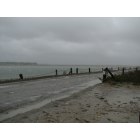
Duxbury: Powder Point Bridge from Duxbury Beach during 2007 Storm
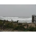
Duxbury: Waves on Duxbury Beach during 2007 Storm

Duxbury: The High School State Crew Meet
- add
your
Submit your own pictures of this place and show them to the world
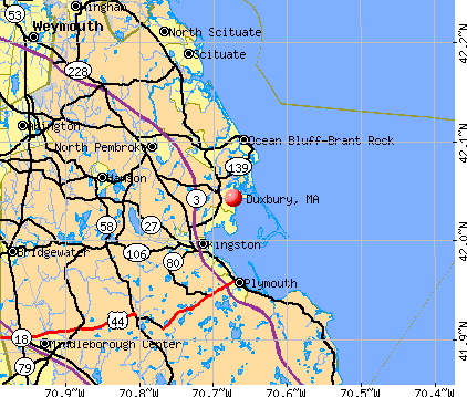
- OSM Map
- General Map
- Google Map
- MSN Map
Population change since 2000: +26.4%
| Males: 960 | |
| Females: 842 |
| Median resident age: | 55.9 years |
| Massachusetts median age: | 40.3 years |
Zip codes: 02332.
| Duxbury: | $125,311 |
| MA: | $94,488 |
Estimated per capita income in 2022: $137,251 (it was $44,589 in 2000)
Duxbury CDP income, earnings, and wages data
Estimated median house or condo value in 2022: over $1,000,000 (it was $515,900 in 2000)
| Duxbury: | over $1,000,000 |
| MA: | $534,700 |
Mean prices in 2022: all housing units: $585,203; detached houses: $620,100; townhouses or other attached units: $487,972; in 2-unit structures: $464,355; in 3-to-4-unit structures: $429,583; in 5-or-more-unit structures: $438,441; mobile homes: $207,706; occupied boats, rvs, vans, etc.: $17,153
Detailed information about poverty and poor residents in Duxbury, MA
Compare current foreclosures near Duxbury, MA:
| Photo | Address | Area | Beds / Baths | Price | Details |
|---|---|---|---|---|---|

|
#1
Heritage Ln
Duxbury, MA 02332
|
5,508 sq. feet
|
1 baths 5 beds |
$759,900
|
show details |

|
#2
Chandler St
Duxbury, MA 02332
|
1,920 sq. feet
|
3 baths 3 beds |
show details | |

|
#3
Chandler St
Duxbury, MA 02332
|
1,265 sq. feet
|
2 baths 2 beds |
show details | |

|
#4
Bay Pond Rd
Duxbury, MA 02332
|
5,822 sq. feet
|
4 baths 5 beds |
show details | |

|
#5
Depot St
Duxbury, MA 02332
|
- sq. feet
|
- baths - beds |
show details | |

|
#6
Tremont St # 104
Duxbury, MA 02332
|
- sq. feet
|
- baths - beds |
show details | |

|
#7
Tall Oaks Dr Unit 508
South Weymouth, MA 02190
|
1,300 sq. feet
|
2 baths 2 beds |
$285,000
|
show details |

|
#8
Prospect St
Norwell, MA 02061
|
5,483 sq. feet
|
5 baths 5 beds |
$1,760,000
|
show details |

|
#9
Kingstown Way
Duxbury, MA 02332
|
- sq. feet
|
- baths - beds |
show details | |

|
#10
Eldon St
Middleboro, MA 02346
|
768 sq. feet
|
1 baths 2 beds |
show details |
| Photo | Address | Area | Beds / Baths | Price | Details |
|---|---|---|---|---|---|

|
#11
Center St
Hanover, MA 02339
|
960 sq. feet
|
1 baths 3 beds |
show details | |

|
#12
Oakwood Ter
East Bridgewater, MA 02333
|
1,052 sq. feet
|
2 baths 3 beds |
show details | |

|
#13
Hillside Dr
Cohasset, MA 02025
|
1,632 sq. feet
|
4 baths 3 beds |
show details | |

|
#14
Ferry St
Marshfield, MA 02050
|
979 sq. feet
|
1 baths 3 beds |
show details | |

|
#15
Bedford St Apt 15
Bridgewater, MA 02324
|
824 sq. feet
|
1 baths 1 beds |
show details | |

|
#16
Boles Rd
Marshfield, MA 02050
|
1,844 sq. feet
|
2 baths 3 beds |
show details | |

|
#17
Wareham St
Middleboro, MA 02346
|
912 sq. feet
|
1 baths 2 beds |
show details | |

|
#18
Hatherly Rd
Scituate, MA 02066
|
1,632 sq. feet
|
2 baths 2 beds |
show details | |

|
#19
Vera Dr
Bridgewater, MA 02324
|
1,836 sq. feet
|
2 baths 3 beds |
show details | |

|
#20
Plymouth Ave
East Wareham, MA 02538
|
1,064 sq. feet
|
2 baths 2 beds |
show details |
| Photo | Address | Area | Beds / Baths | Price | Details |
|---|---|---|---|---|---|

|
#21
Terrace Way
Middleboro, MA 02346
|
972 sq. feet
|
1 baths 2 beds |
show details | |

|
#22
Rockwell Ave
Brockton, MA 02302
|
1,774 sq. feet
|
1 baths 3 beds |
show details | |

|
#23
Lunns Way
Plymouth, MA 02360
|
1,716 sq. feet
|
3 baths 3 beds |
show details | |

|
#24
Wareham St
Middleboro, MA 02346
|
1,060 sq. feet
|
1 baths 3 beds |
show details | |

|
#25
Cappys Way
Brockton, MA 02302
|
2,128 sq. feet
|
2 baths 4 beds |
show details | |

|
#26
Kristin Rd
Plymouth, MA 02360
|
1,204 sq. feet
|
1 baths 3 beds |
show details | |

|
#27
Lydon Ln # A1
Halifax, MA 02338
|
974 sq. feet
|
2 baths 2 beds |
show details | |

|
#28
White Island Rd
Halifax, MA 02338
|
1,424 sq. feet
|
3 baths 4 beds |
show details | |

|
#29
Broadway
Hanover, MA 02339
|
1,778 sq. feet
|
1 baths 2 beds |
show details | |

|
#30
Barquentine Dr
Plymouth, MA 02360
|
1,750 sq. feet
|
2 baths 4 beds |
show details |
| Photo | Address | Area | Beds / Baths | Price | Details |
|---|---|---|---|---|---|

|
#31
Rockland St
Abington, MA 02351
|
1,700 sq. feet
|
1 baths 4 beds |
show details | |

|
#32
Washburn St
Middleboro, MA 02346
|
2,298 sq. feet
|
3 baths 4 beds |
show details | |

|
#33
Huntington Rd
Plymouth, MA 02360
|
1,112 sq. feet
|
2 baths 3 beds |
show details | |

|
#34
Water St
Hanover, MA 02339
|
1,681 sq. feet
|
2 baths 3 beds |
show details | |

|
#35
Wampatuck St
Pembroke, MA 02359
|
1,760 sq. feet
|
2 baths 3 beds |
show details | |

|
#36
Court St # 1
Whitman, MA 02382
|
1,620 sq. feet
|
3 baths 3 beds |
show details | |

|
#37
Yale Ave
Plymouth, MA 02360
|
1,524 sq. feet
|
3 baths 4 beds |
show details | |

|
#38
Court St
Brockton, MA 02302
|
1,376 sq. feet
|
1 baths 3 beds |
show details | |

|
#39
Waltham St
Hanson, MA 02341
|
1,529 sq. feet
|
1 baths 3 beds |
show details | |

|
#40
Pine Tree Dr
Middleboro, MA 02346
|
1,456 sq. feet
|
1 baths 5 beds |
show details |
| Photo | Address | Area | Beds / Baths | Price | Details |
|---|---|---|---|---|---|

|
#41
Hughes St
Plymouth, MA 02360
|
1,286 sq. feet
|
1 baths 3 beds |
show details | |

|
#42
Courtfield Dr
Brockton, MA 02302
|
1,056 sq. feet
|
1 baths 3 beds |
show details | |

|
#43
N Main St
Middleboro, MA 02346
|
1,898 sq. feet
|
2 baths 4 beds |
show details | |

|
#44
Briar Path Way
Carver, MA 02330
|
1,654 sq. feet
|
2 baths 4 beds |
show details | |

|
#45
Randolph St
Abington, MA 02351
|
1,631 sq. feet
|
1 baths 4 beds |
show details | |

|
#46
Washington St Apt B18
Pembroke, MA 02359
|
1,348 sq. feet
|
2 baths 2 beds |
show details | |

|
#47
Kimberly Dr
Whitman, MA 02382
|
1,566 sq. feet
|
2 baths 3 beds |
show details | |

|
#48
Union St
South Weymouth, MA 02190
|
936 sq. feet
|
1 baths 2 beds |
show details | |

|
#49
Plainfield Rd
Marshfield, MA 02050
|
1,965 sq. feet
|
2 baths 3 beds |
show details | |

|
Check over 1 million property listings on Foreclosure.com!
|
browse all offers | |||


- 1,69295.5%White alone
- 482.7%Two or more races
- 60.3%Hispanic
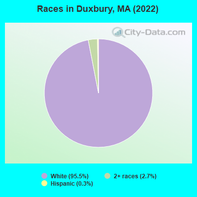
Races in Duxbury detailed stats: ancestries, foreign born residents, place of birth
According to our research of Massachusetts and other state lists, there were 2 registered sex offenders living in Duxbury, Massachusetts as of May 31, 2024.
The ratio of all residents to sex offenders in Duxbury is 759 to 1.
Type |
2009 |
2010 |
2011 |
2012 |
2013 |
2014 |
2015 |
2016 |
2017 |
2018 |
2019 |
2020 |
2021 |
2022 |
|---|---|---|---|---|---|---|---|---|---|---|---|---|---|---|
| Murders (per 100,000) | 0 (0.0) | 0 (0.0) | 0 (0.0) | 0 (0.0) | 0 (0.0) | 0 (0.0) | 0 (0.0) | 0 (0.0) | 0 (0.0) | 0 (0.0) | 0 (0.0) | 0 (0.0) | 0 (0.0) | 0 (0.0) |
| Rapes (per 100,000) | 0 (0.0) | 1 (6.6) | 0 (0.0) | 0 (0.0) | 0 (0.0) | 4 (26.0) | 2 (12.9) | 2 (12.9) | 2 (12.4) | 0 (0.0) | 2 (12.6) | 3 (18.1) | 3 (17.9) | 2 (11.9) |
| Robberies (per 100,000) | 0 (0.0) | 2 (13.3) | 0 (0.0) | 0 (0.0) | 0 (0.0) | 2 (13.0) | 0 (0.0) | 0 (0.0) | 1 (6.2) | 0 (0.0) | 0 (0.0) | 0 (0.0) | 0 (0.0) | 0 (0.0) |
| Assaults (per 100,000) | 10 (68.5) | 9 (59.8) | 5 (33.0) | 3 (19.6) | 2 (13.1) | 4 (26.0) | 12 (77.6) | 12 (77.4) | 6 (37.3) | 7 (43.6) | 7 (43.9) | 8 (48.3) | 7 (41.7) | 15 (89.0) |
| Burglaries (per 100,000) | 29 (198.8) | 27 (179.3) | 15 (99.0) | 45 (294.6) | 16 (105.0) | 13 (84.5) | 11 (71.1) | 16 (103.2) | 22 (136.8) | 18 (112.2) | 9 (56.5) | 1 (6.0) | 3 (17.9) | 2 (11.9) |
| Thefts (per 100,000) | 109 (747.2) | 79 (524.6) | 80 (528.0) | 47 (307.7) | 43 (282.1) | 74 (481.0) | 36 (232.8) | 74 (477.5) | 78 (484.9) | 74 (461.1) | 47 (295.0) | 31 (187.2) | 30 (178.8) | 31 (183.9) |
| Auto thefts (per 100,000) | 2 (13.7) | 3 (19.9) | 0 (0.0) | 3 (19.6) | 0 (0.0) | 1 (6.5) | 1 (6.5) | 1 (6.5) | 2 (12.4) | 0 (0.0) | 1 (6.3) | 3 (18.1) | 2 (11.9) | 1 (5.9) |
| Arson (per 100,000) | 1 (6.9) | 1 (6.6) | 0 (0.0) | 0 (0.0) | 0 (0.0) | 0 (0.0) | 0 (0.0) | 0 (0.0) | 0 (0.0) | 1 (6.2) | 1 (6.3) | 1 (6.0) | 0 (0.0) | 0 (0.0) |
| City-Data.com crime index | 58.6 | 56.4 | 34.7 | 38.4 | 21.3 | 55.6 | 40.7 | 52.7 | 49.2 | 35.0 | 35.1 | 33.5 | 32.0 | 35.9 |
The City-Data.com crime index weighs serious crimes and violent crimes more heavily. Higher means more crime, U.S. average is 246.1. It adjusts for the number of visitors and daily workers commuting into cities.
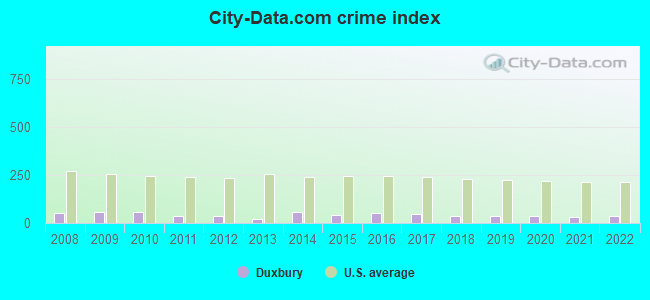
Crime rate in Duxbury detailed stats: murders, rapes, robberies, assaults, burglaries, thefts, arson
Full-time law enforcement employees in 2021, including police officers: 33 (31 officers - 29 male; 2 female).
| Officers per 1,000 residents here: | 1.85 |
| Massachusetts average: | 2.53 |
 Recent articles from our blog. Our writers, many of them Ph.D. graduates or candidates, create easy-to-read articles on a wide variety of topics.

 | Nicer house in Pembroke or hold out for Norwell scituate duxbury? (72 replies) |
| 2024 Real Estate Observations (909 replies) |
| 2023 Real Estate Observations (5278 replies) |
| Population slightly down in MA 2022 (362 replies) |
| 2022 Real Estate Observations (1122 replies) |
| Report finds MA Roadways Dangerous (190 replies) |
Latest news from Duxbury, MA collected exclusively by city-data.com from local newspapers, TV, and radio stations
Ancestries: Irish (47.1%), English (26.6%), Cape Verdean (5.9%), Italian (4.6%), French (3.3%), American (2.8%).
Current Local Time: EST time zone
Incorporated in 1637
Elevation: 36 feet
Land area: 2.17 square miles.
Population density: 829 people per square mile (low).
31 residents are foreign born
| This place: | 1.7% |
| Massachusetts: | 17.6% |
Median real estate property taxes paid for housing units with mortgages in 2022: $9,997 (0.6%)
Median real estate property taxes paid for housing units with no mortgage in 2022: $9,787 (0.8%)
Nearest city with pop. 50,000+: Weymouth, MA  (18.0 miles , pop. 53,988).
Nearest city with pop. 200,000+: Boston, MA (28.8 miles , pop. 589,141).
Nearest city with pop. 1,000,000+: Bronx, NY (185.4 miles , pop. 1,332,650).
Nearest cities:
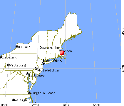
), ), ), ), Latitude: 42.04 N, Longitude: 70.67 W
Area code: 781


Duxbury, Massachusetts accommodation & food services, waste management - Economy and Business Data
Single-family new house construction building permits:
- 2022: 39 buildings, average cost: $480,300
- 2021: 34 buildings, average cost: $554,000
- 2020: 19 buildings, average cost: $571,600
- 2019: 20 buildings, average cost: $492,100
- 2018: 13 buildings, average cost: $495,800
- 2017: 20 buildings, average cost: $496,500
- 2016: 50 buildings, average cost: $426,200
- 2015: 67 buildings, average cost: $322,600
- 2014: 37 buildings, average cost: $282,500
- 2013: 25 buildings, average cost: $320,500
- 2012: 32 buildings, average cost: $277,500
- 2011: 25 buildings, average cost: $279,500
- 2010: 12 buildings, average cost: $516,200
- 2009: 15 buildings, average cost: $326,400
- 2008: 22 buildings, average cost: $291,900
- 2007: 41 buildings, average cost: $281,200
- 2006: 26 buildings, average cost: $323,800
- 2005: 23 buildings, average cost: $266,400
- 2004: 27 buildings, average cost: $269,600
- 2003: 39 buildings, average cost: $221,900
- 2002: 40 buildings, average cost: $244,300
- 2001: 29 buildings, average cost: $199,600
- 2000: 27 buildings, average cost: $185,400
- 1999: 36 buildings, average cost: $180,600
- 1998: 35 buildings, average cost: $172,300
- 1997: 41 buildings, average cost: $166,400
| Here: | 3.6% |
| Massachusetts: | 3.5% |
- Finance & insurance (20.1%)
- Professional, scientific, technical services (14.2%)
- Health care (13.6%)
- Construction (7.5%)
- Arts, entertainment, recreation (4.3%)
- Educational services (4.2%)
- Real estate & rental & leasing (3.4%)
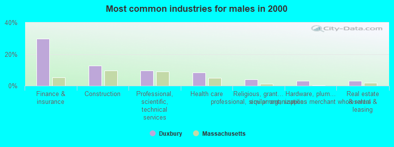
- Finance & insurance (29.7%)
- Construction (12.7%)
- Professional, scientific, technical services (9.7%)
- Health care (8.4%)
- Religious, grantmaking, civic, professional, similar organizations (4.1%)
- Hardware, plumbing & heating equipment, supplies merchant wholesalers (3.2%)
- Real estate & rental & leasing (3.0%)
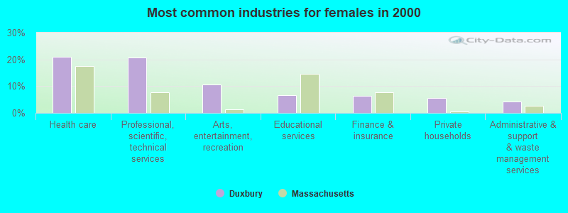
- Health care (21.1%)
- Professional, scientific, technical services (20.7%)
- Arts, entertainment, recreation (10.5%)
- Educational services (6.6%)
- Finance & insurance (6.2%)
- Private households (5.5%)
- Administrative & support & waste management services (4.3%)

- Other management occupations, except farmers and farm managers (8.9%)
- Other sales and related occupations, including supervisors (7.0%)
- Sales representatives, services, wholesale and manufacturing (6.9%)
- Top executives (6.4%)
- Financial managers (6.2%)
- Lawyers (5.6%)
- Counselors, social workers, and other community and social service specialists (4.3%)
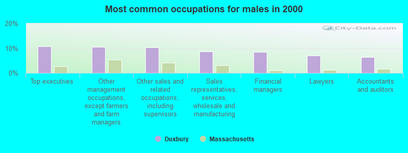
- Top executives (10.8%)
- Other management occupations, except farmers and farm managers (10.5%)
- Other sales and related occupations, including supervisors (10.3%)
- Sales representatives, services, wholesale and manufacturing (8.6%)
- Financial managers (8.4%)
- Lawyers (7.0%)
- Accountants and auditors (6.5%)
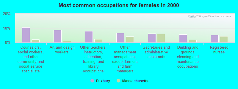
- Counselors, social workers, and other community and social service specialists (10.5%)
- Art and design workers (8.6%)
- Other teachers, instructors, education, training, and library occupations (7.8%)
- Other management occupations, except farmers and farm managers (6.6%)
- Secretaries and administrative assistants (6.2%)
- Building and grounds cleaning and maintenance occupations (5.5%)
- Registered nurses (5.1%)
Average climate in Duxbury, Massachusetts
Based on data reported by over 4,000 weather stations


|
|


(lower is better)
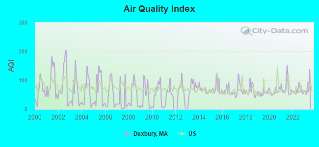
Air Quality Index (AQI) level in 2022 was 64.4. This is about average.
| City: | 64.4 |
| U.S.: | 72.6 |
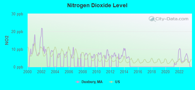
Nitrogen Dioxide (NO2) [ppb] level in 2022 was 5.25. This is about average. Closest monitor was 6.0 miles away from the city center.
| City: | 5.25 |
| U.S.: | 5.11 |
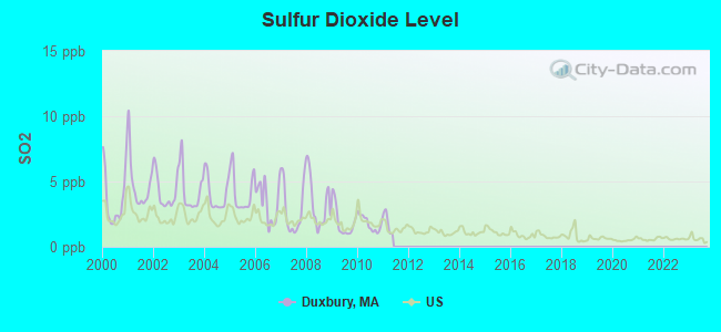
Sulfur Dioxide (SO2) [ppb] level in 2010 was 1.79. This is about average. Closest monitor was 6.0 miles away from the city center.
| City: | 1.79 |
| U.S.: | 1.51 |
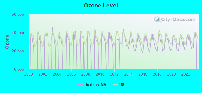
Ozone [ppb] level in 2022 was 29.7. This is about average. Closest monitor was 17.5 miles away from the city center.
| City: | 29.7 |
| U.S.: | 33.3 |
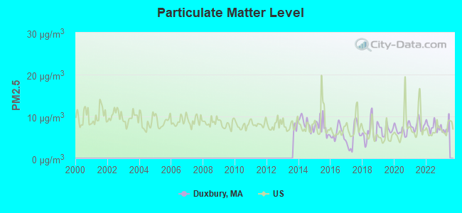
Particulate Matter (PM2.5) [µg/m3] level in 2022 was 7.60. This is about average. Closest monitor was 17.5 miles away from the city center.
| City: | 7.60 |
| U.S.: | 8.11 |
Tornado activity:
Duxbury-area historical tornado activity is below Massachusetts state average. It is 68% smaller than the overall U.S. average.
On 6/9/1953, a category F3 (max. wind speeds 158-206 mph) tornado 27.1 miles away from the Duxbury place center injured 17 people and caused between $500,000 and $5,000,000 in damages.
On 6/9/1953, a category F4 (max. wind speeds 207-260 mph) tornado 46.9 miles away from the place center killed 90 people and injured 1228 people and caused between $50,000,000 and $500,000,000 in damages.
Earthquake activity:
Duxbury-area historical earthquake activity is significantly above Massachusetts state average. It is 75% smaller than the overall U.S. average.On 10/7/1983 at 10:18:46, a magnitude 5.3 (5.1 MB, 5.3 LG, 5.1 ML, Class: Moderate, Intensity: VI - VII) earthquake occurred 227.8 miles away from Duxbury center
On 4/20/2002 at 10:50:47, a magnitude 5.3 (5.3 ML, Depth: 3.0 mi) earthquake occurred 228.8 miles away from the city center
On 10/16/2012 at 23:12:25, a magnitude 4.7 (4.7 ML, Depth: 10.0 mi, Class: Light, Intensity: IV - V) earthquake occurred 107.5 miles away from the city center
On 1/19/1982 at 00:14:42, a magnitude 4.7 (4.5 MB, 4.7 MD, 4.5 LG) earthquake occurred 111.2 miles away from Duxbury center
On 4/20/2002 at 10:50:47, a magnitude 5.2 (5.2 MB, 4.2 MS, 5.2 MW, 5.0 MW) earthquake occurred 228.2 miles away from the city center
On 8/22/1992 at 12:20:32, a magnitude 4.8 (4.8 MB, 3.8 MS, 4.7 LG, Depth: 6.2 mi) earthquake occurred 204.0 miles away from Duxbury center
Magnitude types: regional Lg-wave magnitude (LG), body-wave magnitude (MB), duration magnitude (MD), local magnitude (ML), surface-wave magnitude (MS), moment magnitude (MW)
Natural disasters:
The number of natural disasters in Plymouth County (26) is a lot greater than the US average (15).Major Disasters (Presidential) Declared: 17
Emergencies Declared: 9
Causes of natural disasters: Floods: 11, Storms: 9, Hurricanes: 7, Snows: 3, Snowstorms: 3, Blizzards: 2, Winter Storms: 2, Heavy Rain: 1, Snowfall: 1, Tropical Storm: 1, Wind: 1 (Note: some incidents may be assigned to more than one category).

Hospitals and medical centers in Duxbury:
- BAY PATH AT DUXBURY NURSING AND REHABILITATION CTR (308 KINGSTOWN WAY)
- DUXBURY HOUSE NURSING HOME (298 KINGS TOWN WAY)
Other hospitals and medical centers near Duxbury:
- CRANBERRY HOSPICE (Hospital, about 5 miles away; PLYMOUTH, MA)
- FRESENIUS MEDICAL CARE OF PLYMOUTH CORDAGE (Dialysis Facility, about 5 miles away; PLYMOUTH, MA)
- CENTRUS PREMIER HOME CARE (Home Health Center, about 6 miles away; PLYMOUTH, MA)
- CARE HOME AND HEALTHCARE SERVICES INC (Home Health Center, about 6 miles away; PLYMOUTH, MA)
- BAYADA NURSES INC (Home Health Center, about 6 miles away; PLYMOUTH, MA)
- GENTIVA HEALTH SERVICES - PLYMOUTH (Home Health Center, about 6 miles away; PLYMOUTH, MA)
- PEMBROKE HOSPITAL (Hospital, about 7 miles away; PEMBROKE, MA)
Operable nuclear power plant near Duxbury:
- 7 miles: Pilgrim in Plymouth, MA.
Colleges/universities with over 2000 students nearest to Duxbury:
- Bridgewater State University (about 16 miles; Bridgewater, MA; Full-time enrollment: 9,802)
- Massasoit Community College (about 17 miles; Brockton, MA; FT enrollment: 5,442)
- Stonehill College (about 21 miles; Easton, MA; FT enrollment: 2,563)
- Quincy College (about 23 miles; Quincy, MA; FT enrollment: 3,184)
- Curry College (about 27 miles; Milton, MA; FT enrollment: 2,586)
- University of Massachusetts-Boston (about 27 miles; Boston, MA; FT enrollment: 12,625)
- Suffolk University (about 30 miles; Boston, MA; FT enrollment: 6,982)
Public high schools in Duxbury:
- MADISON PARK HIGH (Students: 1,575, Location: 75 MALCOLM X BLVD, Grades: 9-12)
- O'BRYANT SCHOOL MATH/SCIENCE (Students: 1,264, Location: 55 MALCOLM X BLVD, Grades: 7-12)
- BOSTON DAY AND EVENING ACADEMY CHARTER SCHOOL (Students: 292, Location: 20 KEARSARGE AVE, Grades: 9-12, Charter school)
- CITY ON A HILL CHARTER PUBLIC SCHOOL CIRCUIT STREE (Students: 268, Location: 58 CIRCUIT STREET, Grades: 9-12, Charter school)
- CITY ON A HILL CHARTER PUBLIC SCHOOL DUDLEY SQUARE (Location: 2181 WASHINGTON STREET, Grades: 9-10, Charter school)
Biggest public elementary/middle schools in Duxbury:
- JAMES P TIMILTY MIDDLE (Students: 639, Location: 205 ROXBURY STREET, Grades: 6-8)
- ORCHARD GARDENS (Students: 610, Location: 906 ALBANY STREET, Grades: PK-8)
- RAFAEL HERNANDEZ (Students: 401, Location: 61 SCHOOL STREET, Grades: PK-8)
- MAURICE J TOBIN (Students: 389, Location: 40 SMITH ST, Grades: PK-8)
- DAVID A ELLIS (Students: 283, Location: 302 WALNUT AVENUE, Grades: PK-5)
- SAMUEL W MASON (Students: 217, Location: 150 NORFOLK AVENUE, Grades: PK-5)
- ROXBURY PREPARATORY CHARTER SCHOOL (Students: 191, Location: 120 FISHER AVENUE, Grades: 5-8, Charter school)
- NATHAN HALE (Students: 169, Location: 51 CEDAR STREET, Grades: PK-5)
- ELLIS MENDELL (Students: 166, Location: 164 SCHOOL STREET, Grades: PK-5)
- HIGGINSON/LEWIS K-8 (Location: 131 WALNUT AVENUE, Grades: PK-8)
Private elementary/middle schools in Duxbury:
Points of interest:
Notable locations in Duxbury: Duxbury Yacht Club (A), Duxbury Middle School Media Center (B), Duxbury High School Media Center (C), Carl A Weyerhaeuser Library (D), Duxbury Art Complex (E), Duxbury Free Library (F), John Alden House (G), Windsor House Museum (H). Display/hide their locations on the map
Churches in Duxbury include: Saint John the Evangelist Church (A), Pilgrim Church of Duxbury (B), First Parish Unitarian Church (C). Display/hide their locations on the map
Cemetery: Episcopal Church Cemetery (1). Display/hide its location on the map
Reservoirs and swamps: Bluefish River Reservoir (A), Bluefish River Marshes (B). Display/hide their locations on the map
River: Bluefish River (A). Display/hide its location on the map
Park in Duxbury: Old Shipbuilders Historic District (1). Display/hide its location on the map
Beach: Shipyard Lane Beach (A). Display/hide its location on the map
Tourist attractions: Duxbury Art Complex Inc Museum (189 Alden Street), Alden House Museum (105 Alden Street).
Hotel: Duxbury Clipper (11 South Station Street).
Birthplace of: Pat Leahy (ice hockey) - Ice hockey player, Peleg Wadsworth - Continental Army officer, Stet Howland - Rock drummer, George Partridge - Politician, Peleg Sprague (Maine politician) - Federal judge, William H. Kent - Politician, Chris Ajemian - Lacrosse player, Jim Manganello - Soccer player, Mark Murphy (ice hockey) - Ice hockey player.
Drinking water stations with addresses in Duxbury and their reported violations in the past:
DUXBURY WATER DEPARTMENT (Population served: 15,765, Groundwater):Past health violations:
- MCL, Monthly (TCR) - In NOV-2011, Contaminant: Coliform. Follow-up actions: St AO (w/o penalty) issued (JAN-31-2012), St Compliance achieved (JAN-31-2012)
| This place: | 2.8 people |
| Massachusetts: | 2.5 people |
| This place: | 79.8% |
| Whole state: | 63.0% |
| This place: | 2.3% |
| Whole state: | 7.0% |
Likely homosexual households (counted as self-reported same-sex unmarried-partner households)
- Lesbian couples: 0.6% of all households
- Gay men: 0.0% of all households
Banks with branches in Duxbury (2011 data):
- Rockland Trust Company: Duxbury Branch at 290 Kingstown Way, branch established on 1995/01/18; Duxbury Branch at 27 Bay Road At Hall's Corner, branch established on 1962/01/03. Info updated 2009/05/20: Bank assets: $4,974.4 mil, Deposits: $3,903.9 mil, headquarters in Rockland, MA, positive income, Commercial Lending Specialization, 67 total offices, Holding Company: Independent Bank Corp.
- Sovereign Bank, National Association: Duxbury Branch at 64 Depot Street, branch established on 1962/04/30. Info updated 2012/01/31: Bank assets: $78,146.9 mil, Deposits: $48,042.9 mil, headquarters in Wilmington, DE, positive income, Commercial Lending Specialization, 718 total offices, Holding Company: Banco Santander, S.A.
- Eastern Bank: Depot Street Branch at 19 Depot Street, branch established on 1977/09/19. Info updated 2011/03/30: Bank assets: $7,812.9 mil, Deposits: $6,295.8 mil, headquarters in Boston, MA, positive income, Commercial Lending Specialization, 94 total offices, Holding Company: Eastern Bank Corporation
For population 15 years and over in Duxbury:
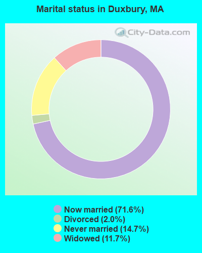
- Never married: 14.7%
- Now married: 71.6%
- Separated: 0.0%
- Widowed: 11.7%
- Divorced: 2.0%
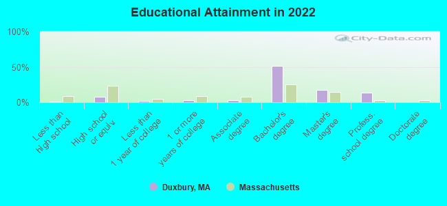
For population 25 years and over in Duxbury:
- High school or higher: 97.9%
- Bachelor's degree or higher: 80.7%
- Graduate or professional degree: 28.9%
- Unemployed: 2.3%
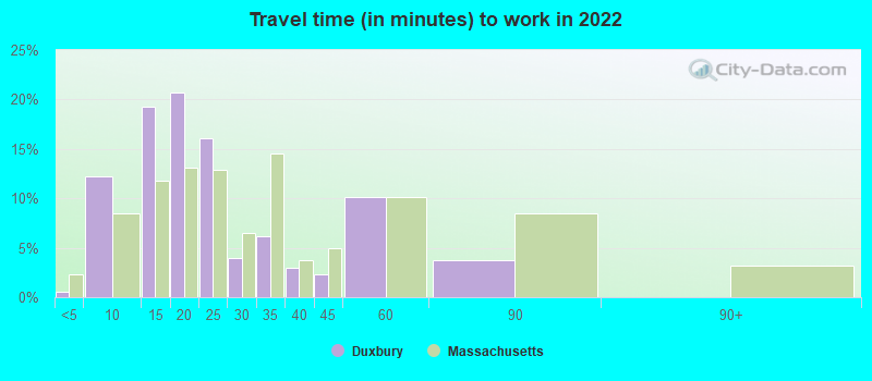
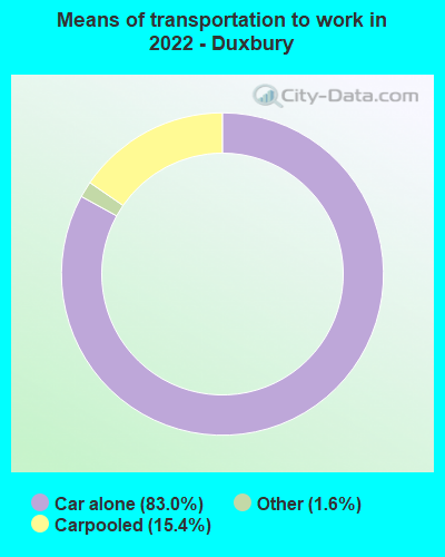
- Mean travel time to work (commute): 43.0 minutes
| Here: | 7.0 |
| Massachusetts average: | 13.0 |


Graphs represent county-level data. Detailed 2008 Election Results
Religion statistics for Duxbury, MA (based on Plymouth County data)


| Religion | Adherents | Congregations |
|---|---|---|
| Catholic | 165,985 | 35 |
| Mainline Protestant | 23,724 | 91 |
| Evangelical Protestant | 13,159 | 96 |
| Other | 6,129 | 43 |
| Orthodox | 1,140 | 3 |
| Black Protestant | 611 | 5 |
| None | 284,171 | - |
Food Environment Statistics:
| Here: | 1.74 / 10,000 pop. |
| Massachusetts: | 1.98 / 10,000 pop. |
| Here: | 0.04 / 10,000 pop. |
| State: | 0.05 / 10,000 pop. |
| Plymouth County: | 2.84 / 10,000 pop. |
| Massachusetts: | 2.22 / 10,000 pop. |
| Here: | 2.20 / 10,000 pop. |
| Massachusetts: | 1.77 / 10,000 pop. |
| Plymouth County: | 7.37 / 10,000 pop. |
| State: | 8.76 / 10,000 pop. |
| This county: | 7.9% |
| State: | 8.1% |
| Plymouth County: | 21.7% |
| Massachusetts: | 22.5% |
| Here: | 16.3% |
| Massachusetts: | 16.5% |
Health and Nutrition:
| Duxbury: | 50.7% |
| Massachusetts: | 50.5% |
| Here: | 51.4% |
| Massachusetts: | 48.0% |
| Duxbury: | 27.8 |
| Massachusetts: | 28.4 |
| This city: | 19.9% |
| State: | 20.7% |
| Duxbury: | 10.6% |
| Massachusetts: | 10.4% |
| Duxbury: | 6.5 |
| Massachusetts: | 6.8 |
| Here: | 32.9% |
| Massachusetts: | 33.4% |
| This city: | 61.5% |
| Massachusetts: | 57.1% |
| Duxbury: | 85.7% |
| Massachusetts: | 79.2% |
More about Health and Nutrition of Duxbury, MA Residents
5.54% of this county's 2020 resident taxpayers moved to other counties in 2021 ($85,482 average adjusted gross income)
| Here: | 5.54% |
| Massachusetts average: | 7.18% |
0.01% of residents moved to foreign countries ($80 average AGI)
Plymouth County: 0.01% Massachusetts average: 0.02%
Top counties to which taxpayers relocated from this county between 2020 and 2021:
| to Bristol County, MA | |
| to Norfolk County, MA | |
| to Suffolk County, MA |
| Businesses in Duxbury, MA | ||||
| Name | Count | Name | Count | |
|---|---|---|---|---|
| Dunkin Donuts | 1 | Rite Aid | 1 | |
| FedEx | 6 | Talbots | 1 | |
| Jones New York | 1 | UPS | 2 | |
| MasterBrand Cabinets | 1 | |||
Strongest AM radio stations in Duxbury:
- WBZ (1030 AM; 50 kW; BOSTON, MA; Owner: INFINITY BROADCASTING OPERATIONS, INC.)
- WPLM (1390 AM; 5 kW; PLYMOUTH, MA; Owner: PLYMOUTH ROCK BROADCASTING CO., INC.)
- WEEI (850 AM; 50 kW; BOSTON, MA; Owner: ENTERCOM BOSTON LICENSE, LLC)
- WRKO (680 AM; 50 kW; BOSTON, MA; Owner: ENTERCOM BOSTON LICENSE, LLC)
- WWZN (1510 AM; 50 kW; BOSTON, MA; Owner: ROSE CITY RADIO CORPORATION)
- WKOX (1200 AM; 50 kW; FRAMINGHAM, MA; Owner: CAPSTAR TX LIMITED PARTNERSHIP)
- WALE (990 AM; 50 kW; GREENVILLE, RI; Owner: NORTH AMERICAN BROADCASTING CO., INC.)
- WBIX (1060 AM; 40 kW; NATICK, MA; Owner: LANGER BROADCASTING CORPORATION)
- WAMG (890 AM; 25 kW; DEDHAM, MA; Owner: MEGA COMMUNICATIONS OF DEDHAM LICENSEE, LLC)
- WRCA (1330 AM; 25 kW; WALTHAM, MA; Owner: WRCA LICENSE, LLC)
- WCRN (830 AM; 50 kW; WORCESTER, MA; Owner: CARTER BROADCASTING CORPORATION)
- WUNR (1600 AM; 20 kW; BROOKLINE, MA; Owner: CHAMPION BROADCASTING SYSTEMS, INC.)
- WBET (1460 AM; 5 kW; BROCKTON, MA; Owner: KJI BROADCASTING, LLC)
Strongest FM radio stations in Duxbury:
- WATD-FM (95.9 FM; MARSHFIELD, MA; Owner: MARSHFIELD BROADCASTING CO., INC.)
- WPLM-FM (99.1 FM; PLYMOUTH, MA; Owner: PLYMOUTH ROCK BROADCASTING CO., INC.)
- WXKS-FM (107.9 FM; MEDFORD, MA; Owner: AMFM RADIO LICENSES, L.L.C.)
- WMJX (106.7 FM; BOSTON, MA; Owner: GREATER BOSTON RADIO, INC.)
- WBMX (98.5 FM; BOSTON, MA; Owner: INFINITY RADIO OPERATIONS INC.)
- WBOS (92.9 FM; BROOKLINE, MA; Owner: GREATER BOSTON RADIO, INC.)
- WJMN (94.5 FM; BOSTON, MA; Owner: AMFM RADIO LICENSES, L.L.C.)
- WCRB (102.5 FM; WALTHAM, MA; Owner: CHARLES RIVER BROADCASTING WCRB LICE)
- WTKK (96.9 FM; BOSTON, MA; Owner: GREATER BOSTON RADIO, INC.)
- WROR-FM (105.7 FM; FRAMINGHAM, MA; Owner: GREATER BOSTON RADIO, INC.)
- WGBH (89.7 FM; BOSTON, MA; Owner: WGBH EDUCATIONAL FOUNDATION)
- WBOT (97.7 FM; BROCKTON, MA; Owner: RADIO ONE LICENSES, LLC)
- WBUR-FM (90.9 FM; BOSTON, MA; Owner: TRUSTEES OF BOSTON UNIVERSITY)
- WWBB (101.5 FM; PROVIDENCE, RI; Owner: CLEAR CHANNEL BROADCASTING LICENSES, INC.)
- WBCN (104.1 FM; BOSTON, MA; Owner: HEMISPHERE BROADCASTING CORPORATION)
- WZLX (100.7 FM; BOSTON, MA; Owner: INFINITY BROADCASTING CORPORATION OF BOSTON)
- W267AI (101.3 FM; BOSTON, MA; Owner: MCC BROADCASTING COMPANY, INC.)
- WODS (103.3 FM; BOSTON, MA; Owner: INFINITY BROADCASTING OPERATIONS, INC.)
- WERS (88.9 FM; BOSTON, MA; Owner: EMERSON COLLEGE)
- WHRB (95.3 FM; CAMBRIDGE, MA; Owner: HARVARD RADIO BROADCASTING CO., INC.)
TV broadcast stations around Duxbury:
- WWDP (Channel 46; NORWELL, MA; Owner: NORWELL TELEVISION, LLC)
- WCVB-TV (Channel 5; BOSTON, MA; Owner: WCVB HEARST-ARGYLE TV, INC.)
- WGBH-TV (Channel 2; BOSTON, MA; Owner: WGBH EDUCATIONAL FOUNDATION)
- WHDH-TV (Channel 7; BOSTON, MA; Owner: WHDH-TV)
- WMFP (Channel 62; LAWRENCE, MA; Owner: WSAH LICENSE, INC.)
- WSBK-TV (Channel 38; BOSTON, MA; Owner: VIACOM INC.)
- WLVI-TV (Channel 56; CAMBRIDGE, MA; Owner: WLVI, INC.)
- WLWC (Channel 28; NEW BEDFORD, MA; Owner: C-28 FCC LICENSEE SUBSIDIARY, LLC)
- WBZ-TV (Channel 4; BOSTON, MA; Owner: VIACOM INC.)
- WGBX-TV (Channel 44; BOSTON, MA; Owner: WGBH EDUCATIONAL FOUNDATION)
- WFXT (Channel 25; BOSTON, MA; Owner: FOX TELEVISION STATIONS INC.)
- WBPX (Channel 68; BOSTON, MA; Owner: PAXSON BOSTON-68 LICENSE, INC.)
- WLNE-TV (Channel 6; NEW BEDFORD, MA; Owner: FREEDOM BROADCASTING OF SOUTHERN NEW ENGLAND, INC.)
- WTMU-LP (Channel 32; BOSTON, MA; Owner: ZGS BOSTON, INC.)
- WCEA-LP (Channel 58; BOSTON, MA; Owner: CHANNEL 19 TV CORPORATION)
- WPRI-TV (Channel 12; PROVIDENCE, RI; Owner: TVL BROADCASTING OF RHODE ISLAND, LLC)
- WNAC-TV (Channel 64; PROVIDENCE, RI; Owner: WNAC, LLC)
- W40BO (Channel 40; BOSTON, MA; Owner: PAXSON COMMUNICATIONS LPTV, INC.)
- WJAR (Channel 10; PROVIDENCE, RI; Owner: OUTLET BROADCASTING, INC.)
- WUTF (Channel 66; MARLBOROUGH, MA; Owner: TELEFUTURA BOSTON LLC)
- WSBE-TV (Channel 36; PROVIDENCE, RI; Owner: RHODE ISLAND PUBLIC TELECOM. AUTHORITY)
- Duxbury, Massachusetts
- Fatal accident count57
- Vehicles involved in fatal accidents74
- Fatal accidents involving drunk persons:27
- Fatalities59
- Persons involved in fatal accidents108
- Pedestrians involved in fatal accidents1
- Massachusetts average
- Fatal accident count16835
- Vehicles involved in fatal accidents23461
- Fatal accidents involving drunk persons5667
- Fatalities18134
- Persons involved in fatal accidents38861
- Pedestrians involved in fatal accidents1655
- National Bridge Inventory (NBI) Statistics
- 1Number of bridges
- 220ft / 67.2mTotal length
- $83,020,000Total costs
- 1,950Total average daily traffic
- 16,583Total future (year 2031) average daily traffic
FCC Registered Antenna Towers:
16 (See the full list of FCC Registered Antenna Towers in Duxbury)FCC Registered Commercial Land Mobile Towers:
1 (See the full list of FCC Registered Commercial Land Mobile Towers in Duxbury, MA)FCC Registered Broadcast Land Mobile Towers:
10 (See the full list of FCC Registered Broadcast Land Mobile Towers)FCC Registered Maritime Coast & Aviation Ground Towers:
4- 397 Washington St (Lat: 42.036222 Lon: -70.671694), Type: Building, Overall height: 8 m, Call Sign: KVR467, Licensee ID: L00093822,
Assigned Frequencies: 156.425 MHz, 156.800 MHz, 157.025 MHz, 156.450 MHz, Grant Date: 12/18/2004, Expiration Date: 01/12/2015, Cancellation Date: 03/14/2015, Registrant: Battelle Memorial Institute, 505 King Ave, Columbus, OH 43201, Phone: (614) 424-3282, Fax: (614) 424-4278, Email:
- 553 Washington St (Lat: 42.079556 Lon: -70.670583), Overall height: 10 m, Call Sign: WHU637, Licensee ID: L00002646,
Assigned Frequencies: 156.925 MHz, 156.425 MHz, 156.450 MHz, 156.800 MHz, Grant Date: 01/01/2003, Expiration Date: 01/26/2013, Cancellation Date: 03/30/2013, Registrant: Long Point Marine Inc, 553 Washington St, Duxbury, MA 02332
- 98 King Caesar Rd (Lat: 42.035389 Lon: -70.666139), Type: Building, Overall height: 8 m, Call Sign: WHV606,
Assigned Frequencies: 156.450 MHz, 156.800 MHz, 157.025 MHz, Grant Date: 02/18/1997, Expiration Date: 04/24/2002, Cancellation Date: 07/28/2002, Registrant: Lee M Kennedy, 98 King Caesar Rd, Duxbury, MA 02332
- 553 Washington St. (Lat: 42.046111 Lon: -70.671111), Type: Bant, Structure height: 10.3 m, Overall height: 14.9 m, Call Sign: WQQZ918,
Assigned Frequencies: 156.925 MHz, 156.800 MHz, 156.450 MHz, Grant Date: 04/02/2013, Expiration Date: 04/02/2023, Cancellation Date: 06/03/2023, Certifier: Lawrence W Martin, Registrant: Long Point Marine Inc., 553 Washington St., Duxbury, MA 02332, Phone: (781) 934-5302, Fax: (781) 934-9894, Email:
FCC Registered Amateur Radio Licenses:
72 (See the full list of FCC Registered Amateur Radio Licenses in Duxbury)FAA Registered Aircraft Manufacturers and Dealers:
1 (See the full list of FAA Registered Manufacturers and Dealers in Duxbury)FAA Registered Aircraft:
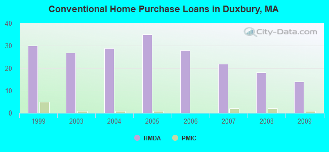
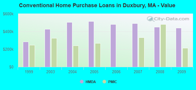
15 (See the full list of FAA Registered Aircraft)| Home Mortgage Disclosure Act Aggregated Statistics For Year 2009 (Based on 2 partial tracts) | ||||||||||
| A) FHA, FSA/RHS & VA Home Purchase Loans | B) Conventional Home Purchase Loans | C) Refinancings | D) Home Improvement Loans | F) Non-occupant Loans on < 5 Family Dwellings (A B C & D) | ||||||
|---|---|---|---|---|---|---|---|---|---|---|
| Number | Average Value | Number | Average Value | Number | Average Value | Number | Average Value | Number | Average Value | |
| LOANS ORIGINATED | 2 | $413,215 | 14 | $440,347 | 91 | $371,745 | 5 | $346,710 | 4 | $302,745 |
| APPLICATIONS APPROVED, NOT ACCEPTED | 0 | $0 | 1 | $409,070 | 8 | $360,879 | 1 | $118,760 | 0 | $0 |
| APPLICATIONS DENIED | 1 | $254,270 | 2 | $308,195 | 16 | $445,897 | 1 | $317,080 | 1 | $245,880 |
| APPLICATIONS WITHDRAWN | 0 | $0 | 2 | $367,180 | 14 | $398,855 | 1 | $301,340 | 2 | $300,790 |
| FILES CLOSED FOR INCOMPLETENESS | 0 | $0 | 0 | $0 | 4 | $248,968 | 0 | $0 | 0 | $0 |
Detailed HMDA statistics for the following Tracts: 5071.03 , 5071.04
| Private Mortgage Insurance Companies Aggregated Statistics For Year 2009 (Based on 2 partial tracts) | ||||
| A) Conventional Home Purchase Loans | B) Refinancings | |||
|---|---|---|---|---|
| Number | Average Value | Number | Average Value | |
| LOANS ORIGINATED | 1 | $214,370 | 0 | $0 |
| APPLICATIONS APPROVED, NOT ACCEPTED | 0 | $0 | 1 | $386,140 |
| APPLICATIONS DENIED | 0 | $0 | 0 | $0 |
| APPLICATIONS WITHDRAWN | 0 | $0 | 0 | $0 |
| FILES CLOSED FOR INCOMPLETENESS | 0 | $0 | 0 | $0 |
Detailed PMIC statistics for the following Tracts: 5071.03 , 5071.04
2002 - 2018 National Fire Incident Reporting System (NFIRS) incidents
- Fire incident types reported to NFIRS in Duxbury, MA
- 32141.6%Structure Fires
- 31340.6%Outside Fires
- 11114.4%Mobile Property/Vehicle Fires
- 263.4%Other
 According to the data from the years 2002 - 2018 the average number of fires per year is 45. The highest number of reported fires - 63 took place in 2007, and the least - 24 in 2002. The data has a rising trend.
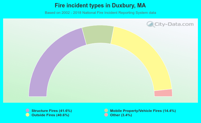 When looking into fire subcategories, the most reports belonged to: Structure Fires (41.6%), and Outside Fires (40.6%).
| Most common first names in Duxbury, MA among deceased individuals | ||
| Name | Count | Lived (average) |
|---|---|---|
| John | 109 | 78.0 years |
| Mary | 105 | 82.2 years |
| William | 90 | 75.4 years |
| Robert | 65 | 75.2 years |
| Margaret | 58 | 82.9 years |
| Helen | 58 | 84.2 years |
| Dorothy | 53 | 82.9 years |
| George | 52 | 76.4 years |
| Elizabeth | 52 | 83.3 years |
| Joseph | 50 | 76.1 years |
| Most common last names in Duxbury, MA among deceased individuals | ||
| Last name | Count | Lived (average) |
|---|---|---|
| White | 18 | 77.3 years |
| Peterson | 18 | 83.6 years |
| Randall | 17 | 76.6 years |
| Smith | 17 | 77.8 years |
| Sullivan | 15 | 78.9 years |
| Johnson | 14 | 78.0 years |
| Loring | 14 | 78.0 years |
| Murphy | 13 | 80.3 years |
| Chandler | 12 | 78.0 years |
| Holmes | 11 | 82.9 years |
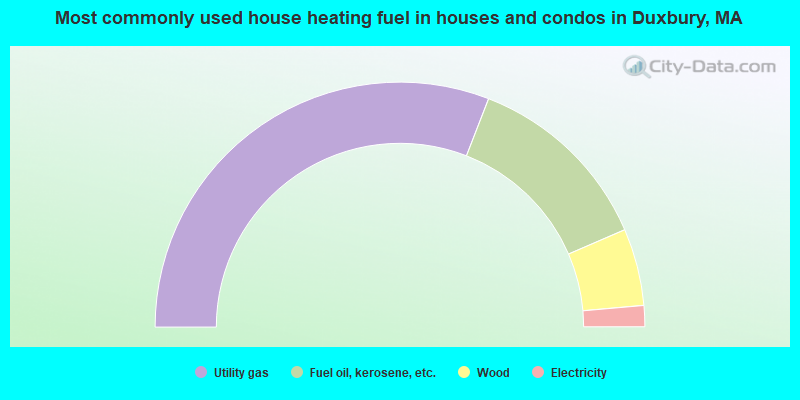
- 61.8%Utility gas
- 25.2%Fuel oil, kerosene, etc.
- 10.2%Wood
- 2.8%Electricity
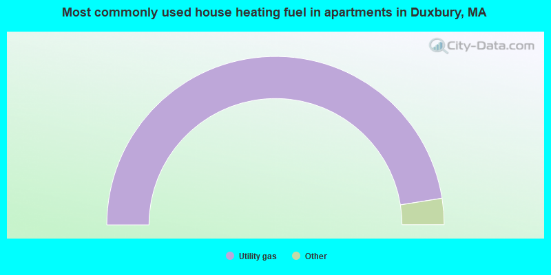
- 100.0%Utility gas
Duxbury compared to Massachusetts state average:
- Median house value significantly above state average.
- Unemployed percentage significantly below state average.
- Black race population percentage significantly below state average.
- Hispanic race population percentage significantly below state average.
- Median age above state average.
- Foreign-born population percentage significantly below state average.
- Renting percentage significantly below state average.
- Length of stay since moving in significantly above state average.
- Number of rooms per house significantly above state average.
- Percentage of population with a bachelor's degree or higher significantly above state average.
Duxbury on our top lists:
- #90 on the list of "Top 101 cities with the most people having Master's or Doctorate degrees (population 500+)"
- #18 on the list of "Top 101 counties with the highest percentage of residents that visited a dentist within the past year"
- #24 on the list of "Top 101 counties with the highest percentage of residents that smoked 100+ cigarettes in their lives"
- #35 on the list of "Top 101 counties with the largest decrease in the number of births per 1000 residents 2000-2006 to 2007-2013 (pop 50,000+)"
- #39 on the list of "Top 101 counties with the lowest percentage of residents that keep firearms around their homes"
- #39 on the list of "Top 101 counties with the lowest number of infant deaths per 1000 residents 2007-2013 (pop. 50,000+)"

|
|
Total of 302 patent applications in 2008-2024.