District 2, Uniontown, Maryland
Submit your own pictures of this city and show them to the world
- OSM Map
- General Map
- Google Map
- MSN Map

| Males: 2,326 | |
| Females: 2,353 |
| Median resident age: | 39.1 years |
| Maryland median age: | 36.0 years |
Zip code: 21158
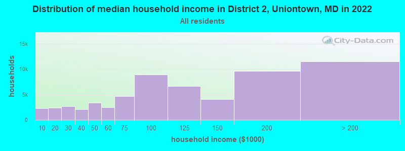
| District 2, Uniontown: | $99,116 |
| MD: | $94,991 |
Estimated per capita income in 2022: $47,232 (it was $22,670 in 2000)
District 2, Uniontown income, earnings, and wages data
Estimated median house or condo value in 2022: $448,901 (it was $176,300 in 2000)
| District 2, Uniontown: | $448,901 |
| MD: | $398,100 |
Mean prices in 2022: all housing units: $437,969; detached houses: $459,464; townhouses or other attached units: $306,699; in 2-unit structures: $253,074; in 3-to-4-unit structures: $406,896; in 5-or-more-unit structures: $226,520; mobile homes: $39,227
District 2, Uniontown, MD residents, houses, and apartments details
Detailed information about poverty and poor residents in District 2, Uniontown, MD
Compare current foreclosures near your location:
| Photo | Address | Area | Beds / Baths | Price | Details |
|---|---|---|---|---|---|

|
#1
E 21st Ave
Columbus, OH 43211
|
1,061 sq. feet
|
1 baths 3 beds |
$179,900
|
show details |

|
#2
S High St
Columbus, OH 43207
|
1,678 sq. feet
|
2 baths 4 beds |
$27,500
|
show details |

|
#3
Bayberry Cir
Columbus, OH 43207
|
1,564 sq. feet
|
1 baths 3 beds |
$127,500
|
show details |

|
#4
Scott St
Columbus, OH 43222
|
1,920 sq. feet
|
2 baths 5 beds |
show details | |

|
#5
Cargin Ct
Canal Winchester, OH 43110
|
1,088 sq. feet
|
1 baths 3 beds |
show details | |

|
#6
Ulry Rd
Westerville, OH 43081
|
1,999 sq. feet
|
2 baths 3 beds |
show details | |

|
#7
Calico Ct
Powell, OH 43065
|
1,171 sq. feet
|
2 baths 3 beds |
show details | |

|
#8
Adell Rd
Columbus, OH 43228
|
920 sq. feet
|
2 baths 4 beds |
show details | |

|
#9
Crooked Cedar Dr
New Albany, OH 43054
|
1,972 sq. feet
|
3 baths 4 beds |
show details | |

|
#10
Pannell Ave
Columbus, OH 43207
|
922 sq. feet
|
1 baths 3 beds |
show details |
| Photo | Address | Area | Beds / Baths | Price | Details |
|---|---|---|---|---|---|

|
#11
Calico Ct
Powell, OH 43065
|
1,150 sq. feet
|
2 baths 3 beds |
show details | |

|
#12
Pinecrest Dr
Blacklick, OH 43004
|
3,627 sq. feet
|
4 baths 4 beds |
show details | |

|
#13
Bennell Dr
Reynoldsburg, OH 43068
|
1,028 sq. feet
|
2 baths 3 beds |
show details | |

|
#14
Forestwind Dr
Grove City, OH 43123
|
1,432 sq. feet
|
2 baths 3 beds |
show details | |

|
#15
Maurine Dr
Columbus, OH 43228
|
1,148 sq. feet
|
1 baths 3 beds |
show details | |

|
#16
E Main St Apt C207
Reynoldsburg, OH 43068
|
960 sq. feet
|
2 baths 2 beds |
show details | |

|
#17
Andrew Rd
Columbus, OH 43227
|
1,053 sq. feet
|
2 baths 3 beds |
show details | |

|
#18
Crofton Ct
Reynoldsburg, OH 43068
|
1,120 sq. feet
|
2 baths 2 beds |
show details | |

|
#19
Argyle Dr
Columbus, OH 43219
|
1,077 sq. feet
|
1 baths 3 beds |
show details | |

|
#20
Azelda St
Columbus, OH 43224
|
720 sq. feet
|
1 baths 3 beds |
show details |
| Photo | Address | Area | Beds / Baths | Price | Details |
|---|---|---|---|---|---|

|
#21
Tuckaway Ct
Columbus, OH 43228
|
1,040 sq. feet
|
3 baths 4 beds |
show details | |

|
#22
Aberdeen Ave
Columbus, OH 43211
|
672 sq. feet
|
1 baths 2 beds |
show details | |

|
#23
Heritage Lakes Dr
Hilliard, OH 43026
|
3,895 sq. feet
|
5 baths 4 beds |
show details | |

|
#24
Hardwood Dr
Galloway, OH 43119
|
2,435 sq. feet
|
3 baths 3 beds |
show details | |

|
#25
Rocky Rd
Columbus, OH 43223
|
1,298 sq. feet
|
2 baths 3 beds |
show details | |

|
#26
Kirkdale Dr
Blacklick, OH 43004
|
1,088 sq. feet
|
2 baths 3 beds |
show details | |

|
#27
Ashgrove Dr
Grove City, OH 43123
|
1,772 sq. feet
|
2 baths 4 beds |
show details | |

|
#28
Edgeview Rd
Columbus, OH 43207
|
1,700 sq. feet
|
1 baths 4 beds |
show details | |

|
#29
Western Hill Rd
Columbus, OH 43223
|
896 sq. feet
|
2 baths 4 beds |
show details | |

|
#30
Sunview Rd
Reynoldsburg, OH 43068
|
1,025 sq. feet
|
1 baths 3 beds |
show details |
| Photo | Address | Area | Beds / Baths | Price | Details |
|---|---|---|---|---|---|

|
#31
Jane Ave
Columbus, OH 43219
|
1,491 sq. feet
|
2 baths 3 beds |
show details | |

|
#32
Delhi Ave
Columbus, OH 43202
|
1,344 sq. feet
|
2 baths 2 beds |
show details | |

|
#33
Minerva Park Pl
Columbus, OH 43229
|
965 sq. feet
|
3 baths 3 beds |
show details | |

|
#34
Firwood Dr
Columbus, OH 43229
|
1,483 sq. feet
|
2 baths 3 beds |
show details | |

|
#35
Genessee Ave
Columbus, OH 43211
|
848 sq. feet
|
1 baths 2 beds |
show details | |

|
#36
Fayburrow Dr
Reynoldsburg, OH 43068
|
1,528 sq. feet
|
3 baths 4 beds |
show details | |

|
#37
Dlyn St
Columbus, OH 43228
|
1,224 sq. feet
|
2 baths 2 beds |
show details | |

|
#38
Blue Rock Ln
Grove City, OH 43123
|
1,756 sq. feet
|
3 baths 4 beds |
show details | |

|
#39
Melrose Ave
Columbus, OH 43224
|
732 sq. feet
|
2 baths 2 beds |
show details | |

|
#40
Sunbury Rd
Columbus, OH 43219
|
1,170 sq. feet
|
1 baths 3 beds |
show details |
| Photo | Address | Area | Beds / Baths | Price | Details |
|---|---|---|---|---|---|

|
#41
Rathbone Ave
Columbus, OH 43214
|
941 sq. feet
|
1 baths 2 beds |
show details | |

|
#42
N Nelson Rd
Columbus, OH 43219
|
2,886 sq. feet
|
2 baths 4 beds |
show details | |

|
#43
Headley Heights Ct
Columbus, OH 43230
|
2,657 sq. feet
|
3 baths 3 beds |
show details | |

|
#44
Sleeping Meadow Dr
New Albany, OH 43054
|
3,211 sq. feet
|
3 baths 4 beds |
show details | |

|
#45
W North Broadway St
Columbus, OH 43214
|
1,400 sq. feet
|
2 baths 3 beds |
show details | |

|
#46
Doral Ave
Columbus, OH 43213
|
2,124 sq. feet
|
3 baths 4 beds |
show details | |

|
#47
Salado Creek Dr
Columbus, OH 43219
|
2,334 sq. feet
|
3 baths 3 beds |
show details | |

|
#48
Hawkins Ln
Blacklick, OH 43004
|
896 sq. feet
|
1 baths 2 beds |
show details | |

|
#49
Voeller Cir
Grove City, OH 43123
|
1,060 sq. feet
|
1 baths 2 beds |
show details | |

|
Check over 1 million property listings on Foreclosure.com!
|
browse all offers | |||

- 4,10297.9%White alone
- 280.7%Hispanic
- 210.5%Asian alone
- 170.4%Two or more races
- 90.2%American Indian alone
- 60.1%Black alone
- 30.07%Other race alone
- 20.05%Native Hawaiian and Other
Pacific Islander alone
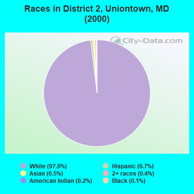
Races in District 2, Uniontown detailed stats: ancestries, foreign born residents, place of birth
 Recent articles from our blog. Our writers, many of them Ph.D. graduates or candidates, create easy-to-read articles on a wide variety of topics.
Current Local Time: EST time zone
Land area: 32.5 square miles.
Population density: 144 people per square mile (very low).

| District 2, Uniontown: | 1.0% ($1,683) |
| Maryland: | 1.2% ($1,782) |
Nearest city with pop. 50,000+: Frederick, MD  (21.5 miles , pop. 52,767).
Nearest city with pop. 200,000+: Baltimore, MD (33.3 miles , pop. 651,154).
Nearest city with pop. 1,000,000+: Philadelphia, PA (107.2 miles , pop. 1,517,550).
Nearest cities:
), ), ), ), )Latitude: 39.61 N, Longitude: 77.10 W

| Here: | 1.6% |
| Maryland: | 2.0% |
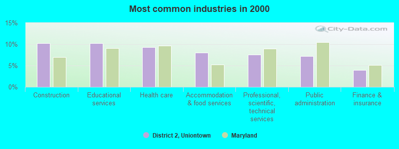
- Construction (10.3%)
- Educational services (10.2%)
- Health care (9.3%)
- Accommodation & food services (8.0%)
- Professional, scientific, technical services (7.5%)
- Public administration (7.2%)
- Finance & insurance (4.0%)
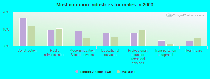
- Construction (16.6%)
- Public administration (9.5%)
- Accommodation & food services (9.1%)
- Educational services (7.9%)
- Professional, scientific, technical services (7.7%)
- Transportation equipment (3.4%)
- Health care (3.3%)
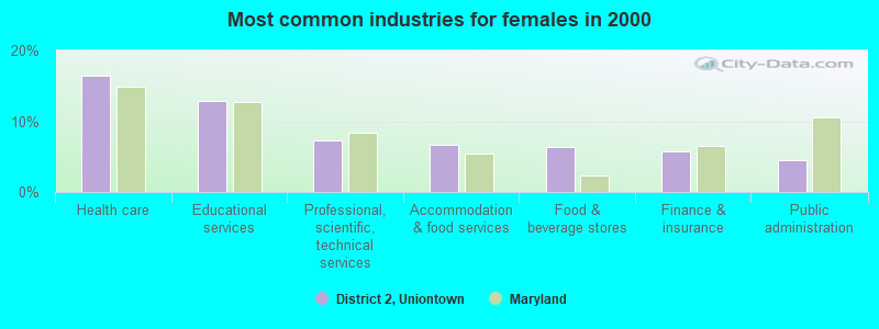
- Health care (16.4%)
- Educational services (12.9%)
- Professional, scientific, technical services (7.3%)
- Accommodation & food services (6.6%)
- Food & beverage stores (6.3%)
- Finance & insurance (5.8%)
- Public administration (4.6%)
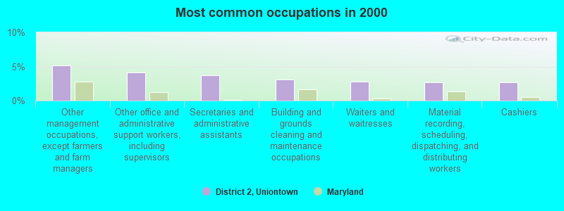
- Other management occupations, except farmers and farm managers (5.1%)
- Other office and administrative support workers, including supervisors (4.2%)
- Secretaries and administrative assistants (3.7%)
- Building and grounds cleaning and maintenance occupations (3.1%)
- Waiters and waitresses (2.7%)
- Material recording, scheduling, dispatching, and distributing workers (2.7%)
- Cashiers (2.7%)
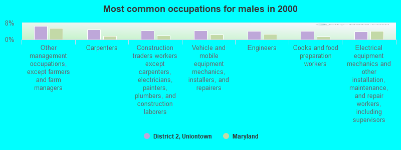
- Other management occupations, except farmers and farm managers (6.6%)
- Carpenters (4.8%)
- Construction traders workers except carpenters, electricians, painters, plumbers, and construction laborers (4.4%)
- Vehicle and mobile equipment mechanics, installers, and repairers (4.4%)
- Engineers (4.1%)
- Cooks and food preparation workers (4.1%)
- Electrical equipment mechanics and other installation, maintenance, and repair workers, including supervisors (3.9%)

- Secretaries and administrative assistants (8.1%)
- Waiters and waitresses (6.0%)
- Cashiers (5.8%)
- Other office and administrative support workers, including supervisors (5.1%)
- Preschool, kindergarten, elementary, and middle school teachers (4.8%)
- Material recording, scheduling, dispatching, and distributing workers (3.8%)
- Information and record clerks, except customer service representatives (3.8%)
Average climate in District 2, Uniontown, Maryland
Based on data reported by over 4,000 weather stations


(lower is better)
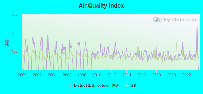
Air Quality Index (AQI) level in 2023 was 92.5. This is worse than average.
| City: | 92.5 |
| U.S.: | 72.6 |
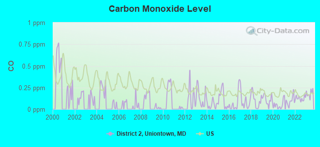
Carbon Monoxide (CO) [ppm] level in 2023 was 0.183. This is better than average. Closest monitor was 22.9 miles away from the city center.
| City: | 0.183 |
| U.S.: | 0.251 |
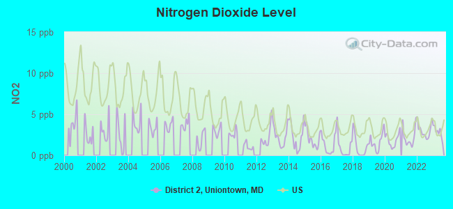
Nitrogen Dioxide (NO2) [ppb] level in 2023 was 2.84. This is significantly better than average. Closest monitor was 7.0 miles away from the city center.
| City: | 2.84 |
| U.S.: | 5.11 |
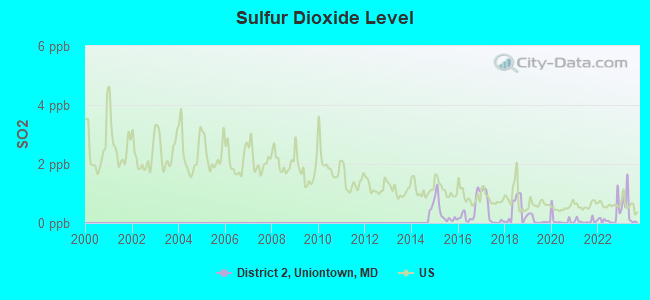
Sulfur Dioxide (SO2) [ppb] level in 2023 was 0.475. This is significantly better than average. Closest monitor was 7.0 miles away from the city center.
| City: | 0.475 |
| U.S.: | 1.515 |
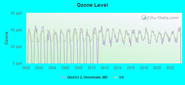
Ozone [ppb] level in 2023 was 37.6. This is about average. Closest monitor was 11.6 miles away from the city center.
| City: | 37.6 |
| U.S.: | 33.3 |
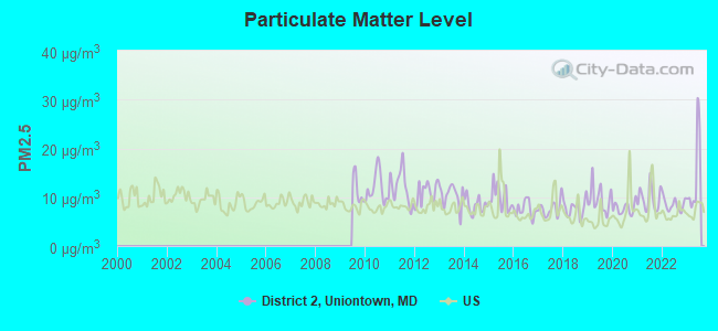
Particulate Matter (PM2.5) [µg/m3] level in 2023 was 14.3. This is significantly worse than average. Closest monitor was 23.9 miles away from the city center.
| City: | 14.3 |
| U.S.: | 8.1 |
Tornado activity:
District 2, Uniontown-area historical tornado activity is slightly above Maryland state average. It is 14% greater than the overall U.S. average.
On 5/22/1983, a category F3 (max. wind speeds 158-206 mph) tornado 9.1 miles away from the District 2, Uniontown city center caused between $5000 and $50,000 in damages.
On 7/19/1996, a category F3 tornado 10.1 miles away from the city center injured 3 people and caused $5 million in damages.
Earthquake activity:
District 2, Uniontown-area historical earthquake activity is significantly above Maryland state average. It is 58% smaller than the overall U.S. average.On 8/23/2011 at 17:51:04, a magnitude 5.8 (5.8 MW, Depth: 3.7 mi, Class: Moderate, Intensity: VI - VII) earthquake occurred 126.2 miles away from District 2, Uniontown center
On 1/16/1994 at 01:49:16, a magnitude 4.6 (4.6 MB, 4.6 LG, Depth: 3.1 mi, Class: Light, Intensity: IV - V) earthquake occurred 75.0 miles away from the city center
On 9/25/1998 at 19:52:52, a magnitude 5.2 (4.8 MB, 4.3 MS, 5.2 LG, 4.5 MW, Depth: 3.1 mi) earthquake occurred 216.5 miles away from the city center
On 8/25/2011 at 05:07:52, a magnitude 4.5 (4.5 ML, Depth: 4.2 mi) earthquake occurred 124.4 miles away from District 2, Uniontown center
On 1/16/1994 at 00:42:43, a magnitude 4.2 (4.2 MB, 4.0 LG, Depth: 3.1 mi) earthquake occurred 76.1 miles away from the city center
On 12/9/2003 at 20:59:18, a magnitude 4.5 (4.5 ML, Depth: 6.2 mi) earthquake occurred 138.2 miles away from the city center
Magnitude types: regional Lg-wave magnitude (LG), body-wave magnitude (MB), local magnitude (ML), surface-wave magnitude (MS), moment magnitude (MW)
Natural disasters:
The number of natural disasters in Carroll County (17) is near the US average (15).Major Disasters (Presidential) Declared: 12
Emergencies Declared: 5
Causes of natural disasters: Hurricanes: 5, Floods: 4, Snowstorms: 3, Storms: 3, Winter Storms: 3, Blizzard: 1, Heavy Rain: 1, Snow: 1, Snowfall: 1, Tropical Storm: 1, Other: 1 (Note: some incidents may be assigned to more than one category).
Hospitals and medical centers near District 2, Uniontown:
- LORIEN TANEYTOWN, INC (Nursing Home, about 4 miles away; TANEYTOWN, MD)
- THERAPY MANAGEMENT SVCS/DBA COMP REHAB (Hospital, about 7 miles away; WESTMINSTER, MD)
- LUTHERAN HOME CARE AND HOSPICE, INC (Home Health Center, about 7 miles away; WESTMINSTER, MD)
- CARROLL HOSPITAL CENTER Acute Care Hospitals (about 8 miles away; WESTMINSTER, MD)
- CARROLL HOME CARE (Home Health Center, about 8 miles away; WESTMINSTER, MD)
- AMBULATORY CARE CTR RICHARD N DIXON (Hospital, about 8 miles away; WESTMINSTER, MD)
- AMEDISYS HOME HEALTH OF WESTMINSTER (Home Health Center, about 8 miles away; WESTMINSTER, MD)
Colleges/universities with over 2000 students nearest to District 2, Uniontown:
- McDaniel College (about 6 miles; Westminster, MD; Full-time enrollment: 2,558)
- Carroll Community College (about 9 miles; Westminster, MD; FT enrollment: 2,682)
- Mount St Mary's University (about 15 miles; Emmitsburg, MD; FT enrollment: 2,313)
- Gettysburg College (about 17 miles; Gettysburg, PA; FT enrollment: 2,772)
- Frederick Community College (about 21 miles; Frederick, MD; FT enrollment: 3,798)
- Stevenson University (about 26 miles; Stevenson, MD; FT enrollment: 3,862)
- Towson University (about 31 miles; Towson, MD; FT enrollment: 19,618)
Points of interest:
Notable locations in District 2, Uniontown: Anazoy Farms (A), Broadview Farm (B), Carolann Farms (C), Joan Lou Farms (D), Arundel Volunteer Fire Department Company 7 (E), Arundel Volunteer Fire Department (F), Pleasant Valley Fire Company (G). Display/hide their locations on the map
Churches in District 2, Uniontown include: Bowens Chapel (A), Pipe Creek Church (B), Mayberry Bethel Church of God (C), Saint Matthew Lutheran Church (D), Bethel Church of God (E), Emmanuel Baust Lutheran Church (F), Saint Paul Lutheran Church (G), Uniontown United Methodist Church (H). Display/hide their locations on the map
Cemeteries: Pleasant Valley Cemetery (1), Mayberry Cemetery (2), Uniontown Cemetery (3), Saint Lucas Cemetery (4), Mount Joy Cemetery (5), Frizzellburg Cemetery (6), Baust Cemetery (7). Display/hide their locations on the map
Streams, rivers, and creeks: Bear Branch (A), Meadow Branch Big Pipe Creek (B), Rattlesnake Branch (C), Log Cabin Branch (D). Display/hide their locations on the map
Park in District 2, Uniontown: Uniontown Historic District (1). Display/hide its location on the map
| This city: | 2.7 people |
| Maryland: | 2.6 people |
| This city: | 81.6% |
| Whole state: | 67.1% |
| This city: | 4.7% |
| Whole state: | 6.4% |
Likely homosexual households (counted as self-reported same-sex unmarried-partner households)
- Lesbian couples: 0.2% of all households
- Gay men: 0.3% of all households
| This city: | 4.0% |
| Whole state: | 8.5% |
| This city: | 1.2% |
| Whole state: | 4.2% |
For population 15 years and over in District 2, Uniontown:
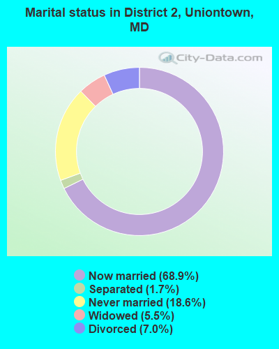
- Never married: 18.6%
- Now married: 68.9%
- Separated: 1.7%
- Widowed: 5.5%
- Divorced: 7.0%
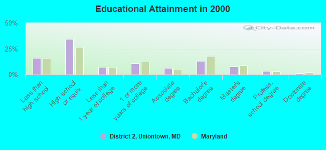
For population 25 years and over in District 2, Uniontown:
- High school or higher: 83.8%
- Bachelor's degree or higher: 24.9%
- Graduate or professional degree: 11.9%
- Unemployed: 1.4%
- Mean travel time to work (commute): 31.8 minutes
| Here: | 11.9 |
| Maryland average: | 12.7 |
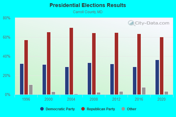
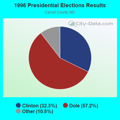
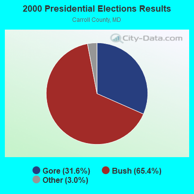


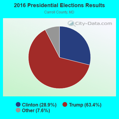
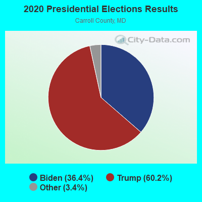
Graphs represent county-level data. Detailed 2008 Election Results
Religion statistics for District 2, Uniontown, MD (based on Carroll County data)
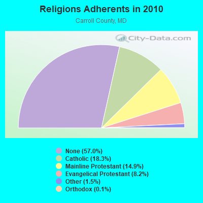
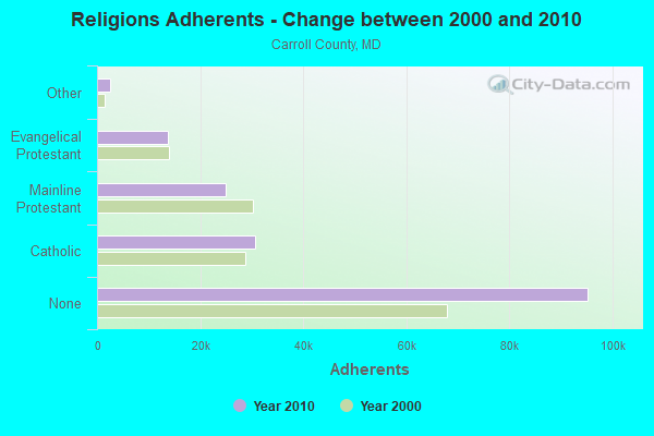
| Religion | Adherents | Congregations |
|---|---|---|
| Catholic | 30,551 | 4 |
| Mainline Protestant | 24,903 | 75 |
| Evangelical Protestant | 13,764 | 68 |
| Other | 2,472 | 9 |
| Orthodox | 226 | 2 |
| None | 95,218 | - |
Food Environment Statistics:
| Carroll County: | 1.18 / 10,000 pop. |
| State: | 1.96 / 10,000 pop. |
| This county: | 0.06 / 10,000 pop. |
| Maryland: | 0.07 / 10,000 pop. |
| Carroll County: | 1.01 / 10,000 pop. |
| Maryland: | 1.22 / 10,000 pop. |
| Here: | 1.84 / 10,000 pop. |
| State: | 2.05 / 10,000 pop. |
| This county: | 5.63 / 10,000 pop. |
| State: | 5.40 / 10,000 pop. |
| This county: | 7.6% |
| Maryland: | 9.1% |
| Carroll County: | 24.5% |
| State: | 26.7% |
| Carroll County: | 13.8% |
| State: | 15.5% |
6.27% of this county's 2020 resident taxpayers moved to other counties in 2021 ($82,015 average adjusted gross income)
| Here: | 6.27% |
| Maryland average: | 7.91% |
0.03% of residents moved to foreign countries ($566 average AGI)
Carroll County: 0.03% Maryland average: 0.04%
Top counties to which taxpayers relocated from this county between 2020 and 2021:
| to Baltimore County, MD | |
| to Frederick County, MD | |
| to York County, PA |
Strongest AM radio stations in District 2, Uniontown:
- WCBM (680 AM; 50 kW; BALTIMORE, MD; Owner: WCBM MARYLAND, INC.)
- WBAL (1090 AM; 50 kW; BALTIMORE, MD; Owner: HEARST RADIO, INC.)
- WGOP (700 AM; daytime; 25 kW; WALKERSVILLE, MD; Owner: BIRACH BROADCASTING CORPORATION)
- WMET (1150 AM; 50 kW; GAITHERSBURG, MD; Owner: BELTWAY ACQUISITION CORPORATION)
- WTTR (1470 AM; 1 kW; WESTMINSTER, MD; Owner: SHAMROCK COMMUNICATIONS, INC.)
- WWLG (1370 AM; 50 kW; BALTIMORE, MD; Owner: M-10 BROADCASTING, INC.)
- WTEM (980 AM; 50 kW; WASHINGTON, DC; Owner: AMFM RADIO LICENSES, L.L.C.)
- WTOP (1500 AM; 50 kW; WASHINGTON, DC; Owner: BONNEVILLE HOLDING COMPANY)
- WHVR (1280 AM; 5 kW; HANOVER, PA)
- WCAO (600 AM; 5 kW; BALTIMORE, MD; Owner: CITICASTERS LICENSES, L.P.)
- WBIS (1190 AM; 50 kW; ANNAPOLIS, MD; Owner: NATIONS RADIO, LLC)
- WPGC (1580 AM; 50 kW; MORNINGSIDE, MD; Owner: INFINITY WPGC(AM), INC.)
- WTRI (1520 AM; daytime; 17 kW; BRUNSWICK, MD; Owner: JMK COMMUNICATIONS, INC.)
Strongest FM radio stations in District 2, Uniontown:
- WAYZ-FM (104.7 FM; HAGERSTOWN, MD; Owner: HJV LIMITED PARTNERSHIP)
- WETH (89.1 FM; HAGERSTOWN, MD; Owner: GREATER WASHINGTON EDUCATIONAL TELECOMMUNICATIONS ASSN.)
- WYCR (98.5 FM; YORK-HANOVER, PA; Owner: RADIO HANOVER, INC.)
- WFRE (99.9 FM; FREDERICK, MD; Owner: CAPSTAR TX LIMITED PARTNERSHIP)
- W219BX (91.7 FM; FREDERICK, MD; Owner: CEDAR RIDGE CHILDREN'S HOME & SCHOOL, INC)
- WGTY (107.7 FM; GETTYSBURG, PA; Owner: TIMES AND NEWS PUBLISHING COMPANY)
- WZBA (100.7 FM; WESTMINSTER, MD; Owner: SHAMROCK COMMUNICATIONS, INC.)
- WWVZ (103.9 FM; BRADDOCK HEIGHTS, MD; Owner: BONNEVILLE HOLDING COMPANY)
- WWMX (106.5 FM; BALTIMORE, MD; Owner: INFINITY RADIO OPERATIONS INC.)
- W219BE (91.7 FM; WAYNESBORO, PA; Owner: MARANATHA BIBLE INSTITUTE, NDBA)
- WROZ (101.3 FM; LANCASTER, PA; Owner: HALL COMMUNICATIONS, INC.)
- WARM-FM (103.3 FM; YORK, PA; Owner: WSBA LICO, INC.)
- WARX (106.9 FM; HAGERSTOWN, MD; Owner: MANNING BROADCASTING INC.)
- WIYY (97.9 FM; BALTIMORE, MD; Owner: HEARST RADIO, INC.)
- WPOC (93.1 FM; BALTIMORE, MD; Owner: CITICASTERS LICENSES, L.P.)
- WLIF (101.9 FM; BALTIMORE, MD; Owner: INFINITY WLIF, INC.)
- WZBT (91.1 FM; GETTYSBURG, PA; Owner: GETTYSBURG COLLEGE)
- WSOX (96.1 FM; RED LION, PA; Owner: LANCASTER-YORK BROADCASTING, LLC)
- WEEO-FM (103.7 FM; MCCONNELLSBURG, PA; Owner: ALLEGHENY MOUNTAIN NETWORK)
- WHBO (92.7 FM; STARVIEW, PA; Owner: HALL COMMUNICATIONS, INC.)
TV broadcast stations around District 2, Uniontown:
- WMPB (Channel 67; BALTIMORE, MD; Owner: MARYLAND PUBLIC BROADCASTING COMMISSION)
- WBAL-TV (Channel 11; BALTIMORE, MD; Owner: WBAL HEARST-ARGYLE TV, INC. (CA CORP.))
- WMAR-TV (Channel 2; BALTIMORE, MD; Owner: SCRIPPS HOWARD BROADCASTING COMPANY)
- WBFF (Channel 45; BALTIMORE, MD; Owner: CHESAPEAKE TELEVISION LICENSEE, LLC)
- WNUV (Channel 54; BALTIMORE, MD; Owner: BALTIMORE (WNUV-TV) LICENSEE, INC.)
- WJZ-TV (Channel 13; BALTIMORE, MD; Owner: VIACOM INC.)
- WUTB (Channel 24; BALTIMORE, MD; Owner: FOX TELEVISION STATIONS, INC.)
- WPMT (Channel 43; YORK, PA; Owner: TRIBUNE TELEVISION COMPANY)
- WFPT (Channel 62; FREDERICK, MD; Owner: MARYLAND PUBLIC BROADCASTING COMMISSION)
- WGAL (Channel 8; LANCASTER, PA; Owner: WGAL HEARST-ARGYLE TELEVISION, INC.)
- W52AS (Channel 52; FREDERICK, MD; Owner: THREE ANGELS BROADCASTING NETWORK)
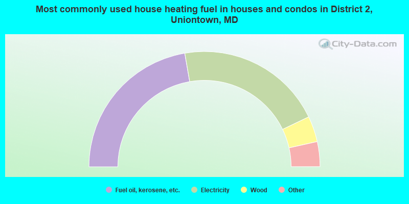
- 44.5%Fuel oil, kerosene, etc.
- 41.2%Electricity
- 7.2%Wood
- 3.8%Bottled, tank, or LP gas
- 1.8%Coal or coke
- 1.2%Utility gas
- 0.3%Other fuel
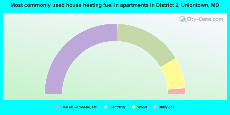
- 51.1%Fuel oil, kerosene, etc.
- 32.0%Electricity
- 14.2%Wood
- 2.7%Utility gas
District 2, Uniontown compared to Maryland state average:
- Unemployed percentage significantly below state average.
- Black race population percentage significantly below state average.
- Hispanic race population percentage significantly below state average.
- Median age above state average.
- Foreign-born population percentage significantly below state average.
- Renting percentage significantly below state average.
- Length of stay since moving in significantly above state average.
- Number of rooms per house significantly below state average.
- House age significantly below state average.