Conway, Kentucky
Submit your own pictures of this place and show them to the world
- OSM Map
- General Map
- Google Map
- MSN Map

| Males: 1,574 | |
| Females: 1,593 |
| Median resident age: | 35.5 years |
| Kentucky median age: | 35.9 years |
Zip code: 40456
| Conway: | $46,714 |
| KY: | $59,341 |
Estimated per capita income in 2022: $26,375 (it was $12,047 in 2000)
Conway CCD income, earnings, and wages data
Estimated median house or condo value in 2022: $128,464 (it was $52,200 in 2000)
| Conway: | $128,464 |
| KY: | $196,300 |
Detailed information about poverty and poor residents in Conway, KY


- 3,11798.0%White alone
- 290.9%Hispanic
- 160.5%Two or more races
- 90.3%American Indian alone
- 50.2%Asian alone
- 30.09%Other race alone
- 10.03%Black alone

Races in Conway detailed stats: ancestries, foreign born residents, place of birth
 Recent articles from our blog. Our writers, many of them Ph.D. graduates or candidates, create easy-to-read articles on a wide variety of topics.
Current Local Time: EST time zone
Land area: 67.0 square miles.
Population density: 47 people per square mile (very low).

| Conway CCD: | 0.6% ($324) |
| Kentucky: | 0.8% ($610) |
Nearest city with pop. 50,000+: Fayette, KY  (40.9 miles , pop. 260,512).
Nearest city with pop. 1,000,000+: Chicago, IL (352.3 miles , pop. 2,896,016).
Nearest cities:
), ), Latitude: 37.46 N, Longitude: 84.30 W
Area code commonly used in this area: 606


| Here: | 4.2% |
| Kentucky: | 3.8% |

- Construction (12.6%)
- Educational services (11.5%)
- Health care (7.0%)
- Accommodation & food services (6.6%)
- Agriculture, forestry, fishing & hunting (5.4%)
- Finance & insurance (3.9%)
- Electrical equipment, appliances, components (3.6%)

- Construction (22.2%)
- Agriculture, forestry, fishing & hunting (9.8%)
- Educational services (6.3%)
- Electrical equipment, appliances, components (5.0%)
- Machinery (4.4%)
- Transportation equipment (4.4%)
- Public administration (3.4%)

- Educational services (17.8%)
- Accommodation & food services (12.8%)
- Health care (12.6%)
- Finance & insurance (5.9%)
- Computer & electronic products (4.0%)
- Social assistance (3.7%)
- Data processing, libraries, other information services (3.5%)

- Carpenters (5.3%)
- Assemblers and fabricators (4.3%)
- Construction traders workers except carpenters, electricians, painters, plumbers, and construction laborers (4.3%)
- Electrical equipment mechanics and other installation, maintenance, and repair workers, including supervisors (3.9%)
- Other production occupations, including supervisors (3.7%)
- Textile, apparel, and furnishings workers (3.4%)
- Farmers and farm managers (3.1%)

- Carpenters (9.6%)
- Construction traders workers except carpenters, electricians, painters, plumbers, and construction laborers (7.9%)
- Electrical equipment mechanics and other installation, maintenance, and repair workers, including supervisors (6.3%)
- Assemblers and fabricators (5.8%)
- Farmers and farm managers (5.6%)
- Other protective service workers, including supervisors (5.1%)
- Other production occupations, including supervisors (4.5%)

- Textile, apparel, and furnishings workers (7.6%)
- Nursing, psychiatric, and home health aides (5.9%)
- Other teachers, instructors, education, training, and library occupations (5.9%)
- Other food preparation and serving workers, including supervisors (5.4%)
- Other office and administrative support workers, including supervisors (4.5%)
- Preschool, kindergarten, elementary, and middle school teachers (4.4%)
- Health technologists and technicians (4.4%)
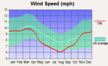
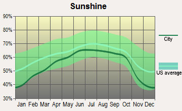
Average climate in Conway, Kentucky
Based on data reported by over 4,000 weather stations


Tornado activity:
Conway-area historical tornado activity is slightly below Kentucky state average. It is 3% greater than the overall U.S. average.
On 4/3/1974, a category F4 (max. wind speeds 207-260 mph) tornado 21.1 miles away from the Conway place center killed 7 people and injured 28 people.
On 4/3/1974, a category F3 (max. wind speeds 158-206 mph) tornado 13.2 miles away from the place center killed 7 people and injured 40 people and caused between $500,000 and $5,000,000 in damages.
Earthquake activity:
Conway-area historical earthquake activity is significantly above Kentucky state average. It is 75% greater than the overall U.S. average.On 7/27/1980 at 18:52:21, a magnitude 5.2 (5.1 MB, 4.7 MS, 5.0 UK, 5.2 UK, Class: Moderate, Intensity: VI - VII) earthquake occurred 55.3 miles away from the city center
On 4/18/2008 at 09:36:59, a magnitude 5.4 (5.1 MB, 4.8 MS, 5.4 MW, 5.2 MW) earthquake occurred 207.1 miles away from Conway center
On 9/7/1988 at 02:28:09, a magnitude 4.6 (4.5 MB, 4.6 LG, Class: Light, Intensity: IV - V) earthquake occurred 52.8 miles away from the city center
On 4/18/2008 at 09:36:59, a magnitude 5.2 (5.2 MW, Depth: 8.9 mi) earthquake occurred 207.1 miles away from Conway center
On 8/9/2020 at 12:07:37, a magnitude 5.1 (5.1 MW, Depth: 4.7 mi) earthquake occurred 190.0 miles away from Conway center
On 11/30/1973 at 07:48:41, a magnitude 4.7 (4.7 MB, 4.6 ML) earthquake occurred 116.3 miles away from the city center
Magnitude types: regional Lg-wave magnitude (LG), body-wave magnitude (MB), local magnitude (ML), surface-wave magnitude (MS), moment magnitude (MW)
Natural disasters:
The number of natural disasters in Rockcastle County (21) is greater than the US average (15).Major Disasters (Presidential) Declared: 15
Emergencies Declared: 2
Causes of natural disasters: Floods: 11, Storms: 10, Mudslides: 6, Tornadoes: 6, Winter Storms: 5, Landslides: 4, Fires: 2, Snowstorms: 2, Winds: 2, Blizzard: 1, Freeze: 1, Hurricane: 1, Snow: 1, Snowfall: 1, Other: 1 (Note: some incidents may be assigned to more than one category).
Hospitals and medical centers near Conway:
- LIFELINE ROCKCASTLE HOME HEALTH (Home Health Center, about 8 miles away; MOUNT VERNON, KY)
- ROCKCASTLE HEALTH AND REHABILITATION CENTER (Nursing Home, about 8 miles away; BRODHEAD, KY)
- BEREA HOSPITAL CHI (Hospital, about 9 miles away; BEREA, KY)
- SAINT JOSEPH BEREA Critical Access Hospitals (about 9 miles away; BEREA, KY)
- THE TERRACE NURSING AND REHABILITATION CENTER (Nursing Home, about 10 miles away; BEREA, KY)
- BEREA HEALTH CARE CENTER (Nursing Home, about 10 miles away; BEREA, KY)
Colleges/universities with over 2000 students nearest to Conway:
- Eastern Kentucky University (about 20 miles; Richmond, KY; Full-time enrollment: 13,525)
- Somerset Community College (about 33 miles; Somerset, KY; FT enrollment: 4,698)
- Bluegrass Community and Technical College (about 41 miles; Lexington, KY; FT enrollment: 8,560)
- University of Kentucky (about 42 miles; Lexington, KY; FT enrollment: 23,517)
- University of the Cumberlands (about 51 miles; Williamsburg, KY; FT enrollment: 3,585)
- Campbellsville University (about 58 miles; Campbellsville, KY; FT enrollment: 2,948)
- Kentucky State University (about 60 miles; Frankfort, KY; FT enrollment: 2,112)
Points of interest:
Notable locations in Conway: Snider Switch Station (A), Brindle Ridge Fire Department (B), Kentucky Music Hall of Fame and Museum (C), Renfro Valley Barn Dance and Pioneer Museum (D). Display/hide their locations on the map
Churches in Conway include: Clear Creek Church (A), Brindle Ridge Baptist Church (B), Macedonia Church (C), Scaffold Cane Church (D), New Testament Church (E), May Apple Church (F), Fairview Church (G), Dicycope Chapel (H). Display/hide their locations on the map
Cemeteries: Merritt Cemetery (1), Rimmel Cemetery (2), Hardin Cemetery (3), Chastine Cemetery (4), Abney Cemetery (5), Fairview Cemetery (6), Sigmon Cemetery (7). Display/hide their locations on the map
Streams, rivers, and creeks: Clay Lick Branch (A), Clear Creek (B), Davis Branch (C), Little Hurricane Branch (D), Loman Branch (E), Renfro Creek (F), Scaffold Cane Branch (G), Todd Branch (H), Valley Spring Branch (I). Display/hide their locations on the map
| This place: | 2.6 people |
| Kentucky: | 2.5 people |
| This place: | 73.1% |
| Whole state: | 66.9% |
| This place: | 6.4% |
| Whole state: | 6.4% |
Likely homosexual households (counted as self-reported same-sex unmarried-partner households)
- Lesbian couples: 0.5% of all households
- Gay men: 0.6% of all households
| This place: | 22.4% |
| Whole state: | 15.8% |
| This place: | 5.8% |
| Whole state: | 6.6% |
People in group quarters in Conway in 2010:
- 28 people in emergency and transitional shelters (with sleeping facilities) for people experiencing homelessness
- 12 people in residential treatment centers for adults
- 11 people in group homes intended for adults
For population 15 years and over in Conway:

- Never married: 19.2%
- Now married: 62.0%
- Separated: 0.8%
- Widowed: 6.9%
- Divorced: 12.0%
For population 25 years and over in Conway:
- High school or higher: 59.3%
- Bachelor's degree or higher: 7.5%
- Graduate or professional degree: 2.8%
- Unemployed: 5.7%
- Mean travel time to work (commute): 26.6 minutes


| Here: | 17.3 |
| Kentucky average: | 13.8 |
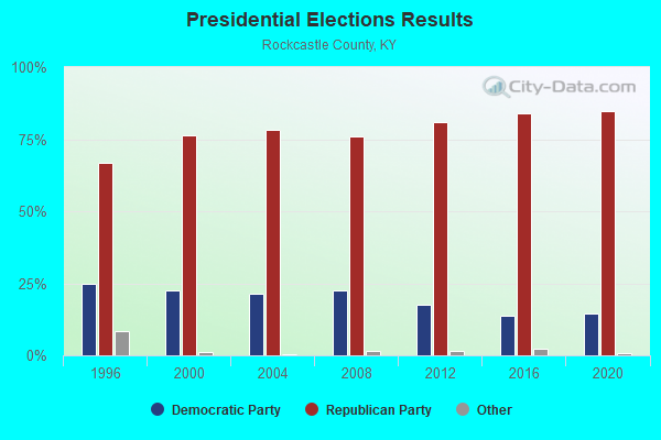
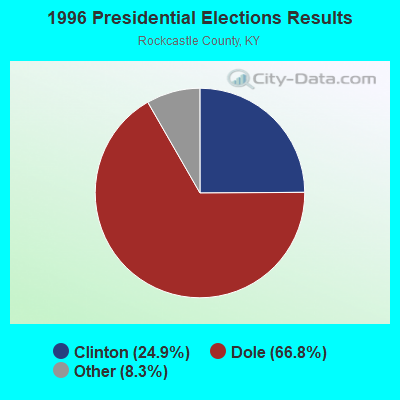
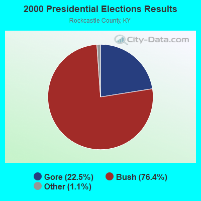
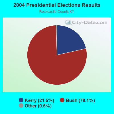
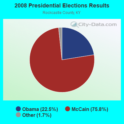
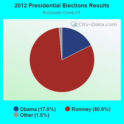

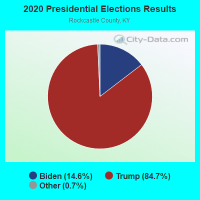
Graphs represent county-level data. Detailed 2008 Election Results
Religion statistics for Conway, KY (based on Rockcastle County data)
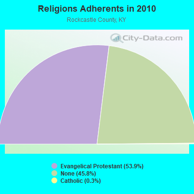
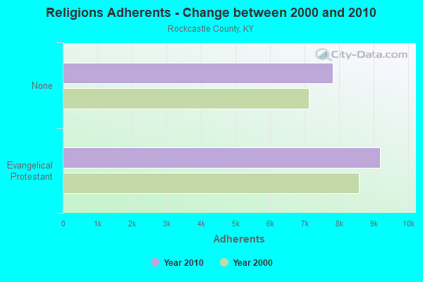
| Religion | Adherents | Congregations |
|---|---|---|
| Evangelical Protestant | 9,193 | 40 |
| Catholic | 48 | 1 |
| Other | - | 1 |
| None | 7,815 | - |
Food Environment Statistics:
| This county: | 2.40 / 10,000 pop. |
| Kentucky: | 2.19 / 10,000 pop. |
| Rockcastle County: | 1.20 / 10,000 pop. |
| Kentucky: | 0.74 / 10,000 pop. |
| Rockcastle County: | 3.00 / 10,000 pop. |
| State: | 4.36 / 10,000 pop. |
| Here: | 5.40 / 10,000 pop. |
| Kentucky: | 5.74 / 10,000 pop. |
| Here: | 11.8% |
| Kentucky: | 11.0% |
| Rockcastle County: | 32.5% |
| State: | 30.0% |
| This county: | 17.4% |
| Kentucky: | 15.9% |
Strongest AM radio stations in Conway:
- WRVK (1460 AM; 0 kW; MOUNT VERNON, KY; Owner: SAYLOR BROADCASTING, INC.)
- WHAS (840 AM; 50 kW; LOUISVILLE, KY; Owner: CLEAR CHANNEL BROADCASTING LICENSES, INC.)
- WKVL (850 AM; daytime; 50 kW; KNOXVILLE, TN; Owner: HORNE RADIO, LLC)
- WLW (700 AM; 50 kW; CINCINNATI, OH; Owner: JACOR BROADCASTING CORPORATION)
- WVLK (590 AM; 5 kW; LEXINGTON, KY; Owner: CUMULUS LICENSING CORP.)
- WLAP (630 AM; 5 kW; LEXINGTON, KY; Owner: CITICASTERS LICENSES, L.P.)
- WKLB (1290 AM; 5 kW; MANCHESTER, KY; Owner: BARKER BROADCASTING COMPANY, INC.)
- WMTC (730 AM; 5 kW; VANCLEVE, KY; Owner: THE KENTUCKY MOUNTAIN HOLINESS ASSN.)
- WTVN (610 AM; 50 kW; COLUMBUS, OH; Owner: CITICASTERS LICENSES, L.P.)
- WSAI (1530 AM; 50 kW; CINCINNATI, OH; Owner: JACOR BROADCASTING CORPORATION)
- WKDP (1330 AM; 5 kW; CORBIN, KY; Owner: EUBANKS BROADCASTING, INC.)
- WSM (650 AM; 50 kW; NASHVILLE, TN; Owner: GAYLORD ENTERTAINMENT COMPANY)
- WEKC (710 AM; daytime; 4 kW; WILLIAMSBURG, KY; Owner: GERALD PARKS)
Strongest FM radio stations in Conway:
- WLFX (106.7 FM; BEREA, KY; Owner: WALLINGFORD COMMUNICATIONS, LLC)
- WCYO (100.7 FM; IRVINE, KY; Owner: KENTUCKY RIVER BROADCASTING CO.)
- WYGE (92.3 FM; LONDON, KY; Owner: ETHEL HUFF BROADCASTING, LLC)
- WEKU (88.9 FM; RICHMOND, KY; Owner: EASTERN KENTUCKY UNIVERSITY)
- WLLK (93.9 FM; BURNSIDE, KY; Owner: CAPSTAR TX LIMITED PARTNERSHIP)
- WTHL (90.5 FM; SOMERSET, KY; Owner: SOMERSET EDUCATIONAL BROADCASTING FOUNDATION)
- WTBK (105.7 FM; MANCHESTER, KY; Owner: MANCHESTER COMMUNICATIONS, INC.)
- WSEK (97.1 FM; SOMERSET, KY; Owner: CAPSTAR TX LIMITED PARTNERSHIP)
- WXKY-FM (96.3 FM; STANFORD, KY; Owner: LINCOLN-GARRARD BROADCASTING CO.,INC)
- WUKY (91.3 FM; LEXINGTON, KY; Owner: BD. OF TRUSTEES UNIV. OF KENTUCKY)
- WRNZ (105.1 FM; LANCASTER, KY; Owner: HOMETOWN BROADCASTING OF LANCASTER, INC.)
- WWAG (107.9 FM; MCKEE, KY; Owner: DANDY BROADCASTING, INC.)
- WSKV-FM (104.9 FM; STANTON, KY; Owner: PARKS BROADCASTING, INC.)
- WVLK-FM (92.9 FM; LEXINGTON, KY; Owner: CUMULUS LICENSING CORP.)
- WLRO (101.5 FM; RICHMOND, KY; Owner: CUMULUS LICENSING CORP.)
- WJMM-FM (99.3 FM; HARRODSBURG, KY; Owner: MORTENSON BROADCASTING COMPANY OF CENTRAL KENTUCKY, LLC)
- WLJC (102.1 FM; BEATTYVILLE, KY; Owner: HOUR OF HARVEST, INCORPORATED)
- WWEL (103.9 FM; LONDON, KY; Owner: F.T.G. BROADCASTING, INC.)
TV broadcast stations around Conway:
- WBLU-LP (Channel 62; LEXINGTON, KY; Owner: SANDRA B. POWLEY)
- WDKY-TV (Channel 56; DANVILLE, KY; Owner: WDKY LICENSEE, LLC)
- WKLE (Channel 46; LEXINGTON, KY; Owner: KENTUCKY AUTHORITY FOR EDUCATIONAL TV)
- WLEX-TV (Channel 18; LEXINGTON, KY; Owner: WLEX COMMUNICATIONS, L.L.C.)
- WKSO-TV (Channel 29; SOMERSET, KY; Owner: KENTUCKY AUTHORITY FOR EDUCATIONAL TV)
- WLJC-TV (Channel 65; BEATTYVILLE, KY; Owner: HOUR OF HARVEST, INC.)
- WUPX-TV (Channel 67; MOREHEAD, KY; Owner: PAXSON LEXINGTON LICENSE, INC.)
- W26BK (Channel 26; TALBERT, KY; Owner: MS COMMUNICATIONS, LLC)
- WKYT-TV (Channel 27; LEXINGTON, KY; Owner: WKYT LICENSEE CORP.)
- WTVQ-TV (Channel 36; LEXINGTON, KY; Owner: MEDIA GENERAL COMMUNICATIONS, INC.)
- WOBZ-LP (Channel 9; EAST BERNSTADT, ETC., KY; Owner: ANDREA JOY KESLER)

Conway fatal accident list:
Jul 4, 2019 05:08 AM, I-75, Lat: 37.533736, Lon: -84.320200, Vehicles: 2, Persons: 3, Fatalities: 1
Aug 4, 2019 07:46 PM, I-75, Lat: 37.462006, Lon: -84.335375, Vehicles: 3, Persons: 6, Fatalities: 1

- 44.3%Electricity
- 27.4%Bottled, tank, or LP gas
- 13.5%Wood
- 10.6%Fuel oil, kerosene, etc.
- 3.6%Coal or coke
- 0.6%Utility gas

- 35.5%Wood
- 28.5%Bottled, tank, or LP gas
- 16.5%Fuel oil, kerosene, etc.
- 10.5%Electricity
- 6.5%Coal or coke
- 2.5%Utility gas
Conway compared to Kentucky state average:
- Median house value below state average.
- Unemployed percentage below state average.
- Black race population percentage significantly below state average.
- Hispanic race population percentage significantly below state average.
- Median age below state average.
- Foreign-born population percentage significantly below state average.
- Renting percentage below state average.
- Length of stay since moving in significantly above state average.
- Number of rooms per house significantly below state average.
- House age significantly below state average.
- Number of college students significantly below state average.
- Percentage of population with a bachelor's degree or higher significantly below state average.