Columbia, New York
Submit your own pictures of this town and show them to the world
- OSM Map
- Google Map
- MSN Map
Population change since 2000: -3.1%
 |
| Males: 817 | |
| Females: 763 |
| Median resident age: | 43.7 years |
| New York median age: | 40.7 years |
Zip codes: 13491.
| Columbia: | $74,326 |
| NY: | $79,557 |
Estimated per capita income in 2022: $33,397 (it was $15,591 in 2000)
Columbia town income, earnings, and wages data
Estimated median house or condo value in 2022: $143,372 (it was $68,400 in 2000)
| Columbia: | $143,372 |
| NY: | $400,400 |
Mean prices in 2022: all housing units: $171,805; detached houses: $188,850; townhouses or other attached units: $180,855; in 2-unit structures: $120,765; in 3-to-4-unit structures: $192,443; in 5-or-more-unit structures: $403,258; mobile homes: $63,441
Detailed information about poverty and poor residents in Columbia, NY


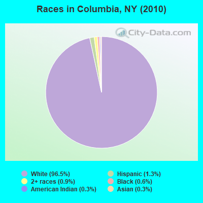
- 1,52496.5%White alone
- 211.3%Hispanic
- 150.9%Two or more races
- 90.6%Black alone
- 50.3%American Indian alone
- 50.3%Asian alone
- 10.06%Other race alone
Races in Columbia detailed stats: ancestries, foreign born residents, place of birth
 Recent articles from our blog. Our writers, many of them Ph.D. graduates or candidates, create easy-to-read articles on a wide variety of topics.
Ancestries: German (24.4%), Irish (17.4%), English (13.6%), Polish (10.2%), French (8.5%), Italian (7.2%).
Current Local Time: EST time zone
Land area: 35.0 square miles.
Population density: 45 people per square mile (very low).
15 residents are foreign born
| This town: | 0.9% |
| New York: | 20.4% |
| Columbia town: | 2.0% ($1,396) |
| New York: | 1.9% ($2,847) |
Nearest city with pop. 50,000+: Utica, NY  (14.9 miles , pop. 60,651).
Nearest city with pop. 200,000+: Rochester, NY (130.6 miles , pop. 219,773).
Nearest city with pop. 1,000,000+: Bronx, NY (156.1 miles , pop. 1,332,650).
Nearest cities:
), ), ), ), )Latitude: 42.93 N, Longitude: 75.05 W
Area code commonly used in this area: 315
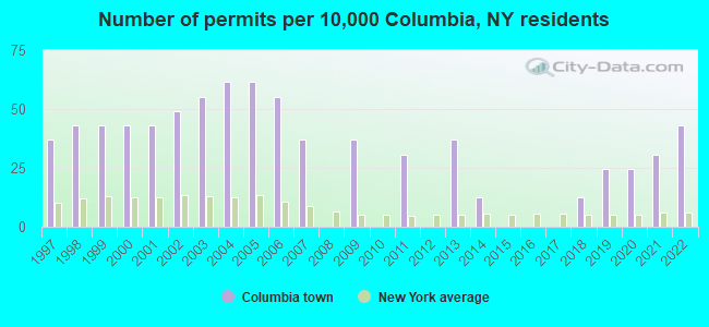
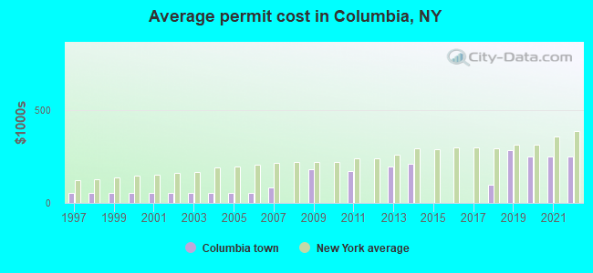
Single-family new house construction building permits:
- 2022: 7 buildings, average cost: $248,200
- 2021: 5 buildings, average cost: $248,200
- 2020: 4 buildings, average cost: $248,200
- 2019: 4 buildings, average cost: $282,200
- 2018: 2 buildings, average cost: $100,000
- 2014: 2 buildings, average cost: $211,200
- 2013: 6 buildings, average cost: $193,300
- 2011: 5 buildings, average cost: $172,800
- 2009: 6 buildings, average cost: $178,900
- 2007: 6 buildings, average cost: $83,300
- 2006: 9 buildings, average cost: $51,800
- 2005: 10 buildings, average cost: $51,800
- 2004: 10 buildings, average cost: $51,800
- 2003: 9 buildings, average cost: $51,800
- 2002: 8 buildings, average cost: $51,800
- 2001: 7 buildings, average cost: $51,800
- 2000: 7 buildings, average cost: $51,800
- 1999: 7 buildings, average cost: $51,800
- 1998: 7 buildings, average cost: $51,800
- 1997: 6 buildings, average cost: $51,800
| Here: | 4.9% |
| New York: | 4.4% |
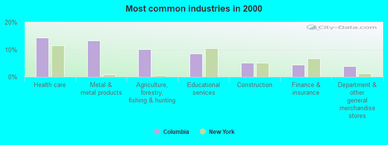
- Health care (14.4%)
- Metal & metal products (13.2%)
- Agriculture, forestry, fishing & hunting (10.1%)
- Educational services (8.4%)
- Construction (5.2%)
- Finance & insurance (4.4%)
- Department & other general merchandise stores (3.9%)
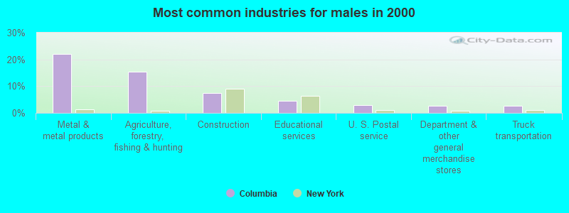
- Metal & metal products (22.0%)
- Agriculture, forestry, fishing & hunting (15.4%)
- Construction (7.6%)
- Educational services (4.4%)
- U. S. Postal service (2.9%)
- Department & other general merchandise stores (2.7%)
- Truck transportation (2.7%)
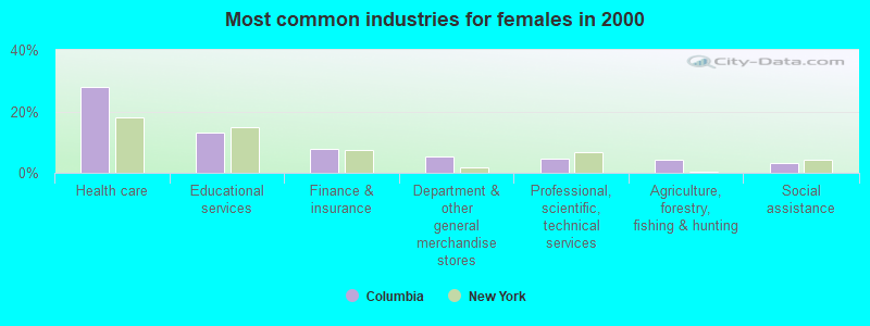
- Health care (28.1%)
- Educational services (13.1%)
- Finance & insurance (7.8%)
- Department & other general merchandise stores (5.3%)
- Professional, scientific, technical services (4.4%)
- Agriculture, forestry, fishing & hunting (4.2%)
- Social assistance (3.3%)
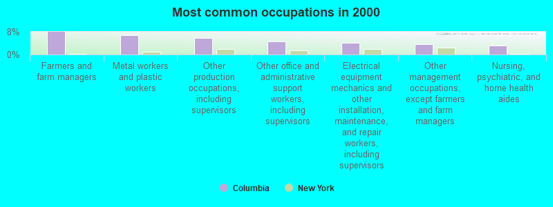
- Farmers and farm managers (7.9%)
- Metal workers and plastic workers (6.8%)
- Other production occupations, including supervisors (5.8%)
- Other office and administrative support workers, including supervisors (4.5%)
- Electrical equipment mechanics and other installation, maintenance, and repair workers, including supervisors (4.2%)
- Other management occupations, except farmers and farm managers (3.6%)
- Nursing, psychiatric, and home health aides (3.2%)
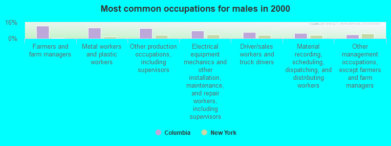
- Farmers and farm managers (12.4%)
- Metal workers and plastic workers (10.7%)
- Other production occupations, including supervisors (10.2%)
- Electrical equipment mechanics and other installation, maintenance, and repair workers, including supervisors (7.8%)
- Driver/sales workers and truck drivers (6.1%)
- Material recording, scheduling, dispatching, and distributing workers (5.1%)
- Other management occupations, except farmers and farm managers (3.9%)
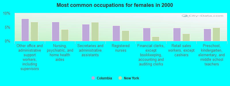
- Other office and administrative support workers, including supervisors (8.1%)
- Nursing, psychiatric, and home health aides (6.9%)
- Secretaries and administrative assistants (6.1%)
- Registered nurses (5.6%)
- Financial clerks, except bookkeeping, accounting and auditing clerks (4.7%)
- Retail sales workers, except cashiers (4.7%)
- Preschool, kindergarten, elementary, and middle school teachers (4.4%)
(lower is better)
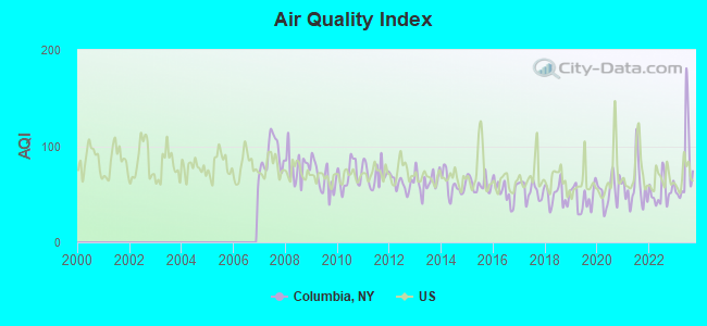
Air Quality Index (AQI) level in 2023 was 77.3. This is about average.
| City: | 77.3 |
| U.S.: | 72.6 |
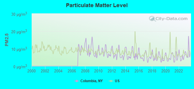
Particulate Matter (PM2.5) [µg/m3] level in 2023 was 7.86. This is about average. Closest monitor was 14.9 miles away from the city center.
| City: | 7.86 |
| U.S.: | 8.11 |
Tornado activity:
Columbia-area historical tornado activity is slightly below New York state average. It is 71% smaller than the overall U.S. average.
On 7/10/1989, a category F4 (max. wind speeds 207-260 mph) tornado 27.1 miles away from the Columbia town center injured 20 people and caused between $5,000,000 and $50,000,000 in damages.
On 5/31/1998, a category F3 (max. wind speeds 158-206 mph) tornado 24.8 miles away from the town center injured 3 people and caused $800,000 in damages.
Earthquake activity:
Columbia-area historical earthquake activity is significantly above New York state average. It is 67% smaller than the overall U.S. average.On 10/7/1983 at 10:18:46, a magnitude 5.3 (5.1 MB, 5.3 LG, 5.1 ML, Class: Moderate, Intensity: VI - VII) earthquake occurred 79.3 miles away from Columbia center
On 4/20/2002 at 10:50:47, a magnitude 5.3 (5.3 ML, Depth: 3.0 mi) earthquake occurred 128.7 miles away from the city center
On 4/20/2002 at 10:50:47, a magnitude 5.2 (5.2 MB, 4.2 MS, 5.2 MW, 5.0 MW) earthquake occurred 126.7 miles away from Columbia center
On 6/17/1991 at 08:53:16, a magnitude 4.1 (4.0 MB, 4.0 LG, Depth: 3.1 mi, Class: Light, Intensity: IV - V) earthquake occurred 27.9 miles away from the city center
On 8/23/2011 at 17:51:04, a magnitude 5.8 (5.8 MW, Depth: 3.7 mi) earthquake occurred 378.9 miles away from the city center
On 1/19/1982 at 00:14:42, a magnitude 4.7 (4.5 MB, 4.7 MD, 4.5 LG) earthquake occurred 178.2 miles away from Columbia center
Magnitude types: regional Lg-wave magnitude (LG), body-wave magnitude (MB), duration magnitude (MD), local magnitude (ML), surface-wave magnitude (MS), moment magnitude (MW)
Natural disasters:
The number of natural disasters in Herkimer County (23) is greater than the US average (15).Major Disasters (Presidential) Declared: 14
Emergencies Declared: 7
Causes of natural disasters: Storms: 12, Floods: 10, Hurricanes: 3, Snowstorms: 2, Tropical Storms: 2, Winds: 2, Blizzard: 1, Power Outage: 1, Tornado: 1, Winter Storm: 1, Other: 2 (Note: some incidents may be assigned to more than one category).
Hospitals and medical centers near Columbia:
- MOHAWK VALLEY GENERAL HOSPITAL (Hospital, about 7 miles away; ILION, NY)
- VALLEY HEALTH SERVICES INC (Nursing Home, about 8 miles away; HERKIMER, NY)
- FOLTS HOME (Nursing Home, about 8 miles away; HERKIMER, NY)
- SUE CAMPAGNA HOSPICE OF HERKIMER CO (Hospital, about 8 miles away; HERKIMER, NY)
- FAXTON ST. LUKE'S HEALTHCARE - HERKIMER (Dialysis Facility, about 8 miles away; HERKIMER, NY)
- HERKIMER CO PUBLIC HLTH CHHA (Home Health Center, about 8 miles away; HERKIMER, NY)
- CHARLES T SITRIN HEALTH CARE S N F (Nursing Home, about 13 miles away; NEW HARTFORD, NY)
Amtrak station near Columbia:
Colleges/universities with over 2000 students nearest to Columbia:
- Herkimer County Community College (about 8 miles; Herkimer, NY; Full-time enrollment: 2,774)
- Mohawk Valley Community College (about 14 miles; Utica, NY; FT enrollment: 5,693)
- Utica College (about 17 miles; Utica, NY; FT enrollment: 2,952)
- Colgate University (about 26 miles; Hamilton, NY; FT enrollment: 3,094)
- Morrisville State College (about 29 miles; Morrisville, NY; FT enrollment: 2,823)
- SUNY Oneonta (about 32 miles; Oneonta, NY; FT enrollment: 6,081)
- SUNY College of Agriculture and Technology at Cobleskill (about 34 miles; Cobleskill, NY; FT enrollment: 2,455)
Points of interest:
Notable locations in Columbia: Schuyler Corners (A), Orendorf Corners (B). Display/hide their locations on the map
Churches in Columbia include: Columbia Church (A), Millers Mills Community Baptist Church (B). Display/hide their locations on the map
Cemeteries: Millers Mills Cemetery (1), Reformed Church Cemetery (2), North Columbia Church Cemetery (3), Brown Cemetery (4), Warren Cemetery (5), Edick Cemetery (6), Fulmer Cemetery (7). Display/hide their locations on the map
Lake: Unadilla Lake (A). Display/hide its location on the map
| This town: | 2.6 people |
| New York: | 2.6 people |
| This town: | 73.4% |
| Whole state: | 63.5% |
| This town: | 9.3% |
| Whole state: | 6.8% |
Likely homosexual households (counted as self-reported same-sex unmarried-partner households)
- Lesbian couples: 0.3% of all households
- Gay men: 0.3% of all households
| This town: | 14.5% |
| Whole state: | 14.6% |
| This town: | 4.7% |
| Whole state: | 7.4% |
For population 15 years and over in Columbia:
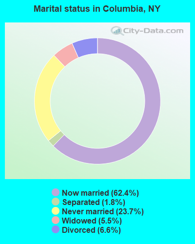
- Never married: 23.7%
- Now married: 62.4%
- Separated: 1.8%
- Widowed: 5.5%
- Divorced: 6.6%
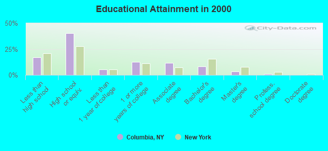
For population 25 years and over in Columbia:
- High school or higher: 83.0%
- Bachelor's degree or higher: 12.9%
- Graduate or professional degree: 4.5%
- Unemployed: 6.8%
- Mean travel time to work (commute): 28.9 minutes
| Here: | 9.7 |
| New York average: | 14.2 |
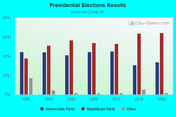
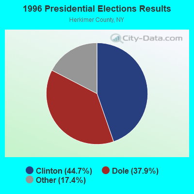
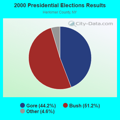
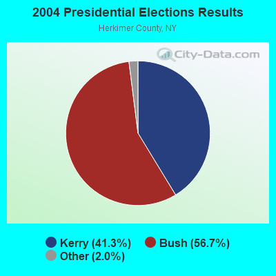
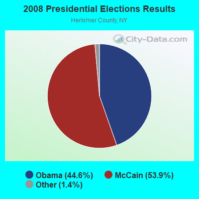
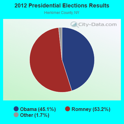
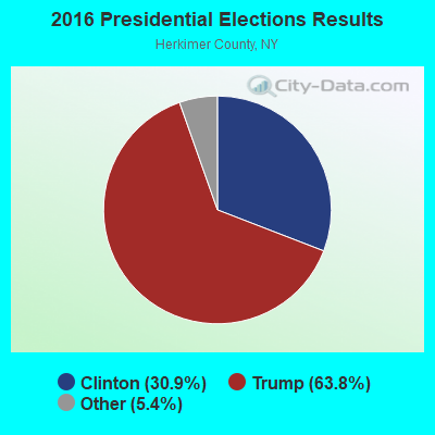
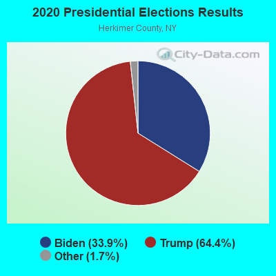
Graphs represent county-level data. Detailed 2008 Election Results
Religion statistics for Columbia, NY (based on Herkimer County data)
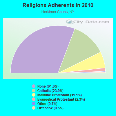
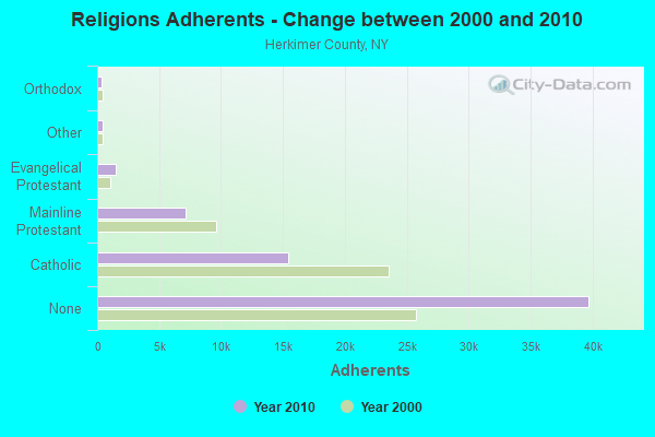
| Religion | Adherents | Congregations |
|---|---|---|
| Catholic | 15,425 | 12 |
| Mainline Protestant | 7,135 | 42 |
| Evangelical Protestant | 1,461 | 22 |
| Other | 450 | 5 |
| Orthodox | 334 | 4 |
| None | 39,714 | - |
Food Environment Statistics:
| Here: | 2.72 / 10,000 pop. |
| New York: | 4.13 / 10,000 pop. |
| This county: | 0.16 / 10,000 pop. |
| New York: | 0.06 / 10,000 pop. |
| This county: | 0.80 / 10,000 pop. |
| New York: | 0.92 / 10,000 pop. |
| This county: | 3.37 / 10,000 pop. |
| State: | 1.68 / 10,000 pop. |
| Here: | 8.82 / 10,000 pop. |
| New York: | 8.82 / 10,000 pop. |
| Herkimer County: | 9.2% |
| New York: | 8.2% |
| This county: | 24.5% |
| New York: | 23.8% |
| This county: | 13.7% |
| New York: | 15.6% |
Strongest AM radio stations in Columbia:
- WGY (810 AM; 50 kW; SCHENECTADY, NY; Owner: CLEAR CHANNEL BROADCASTING LICENSES, INC.)
- WTLB (1310 AM; 5 kW; UTICA, NY; Owner: GALAXY COMMUNICATIONS, L.P.)
- WIBX (950 AM; 5 kW; UTICA, NY; Owner: REGENT LICENSEE OF UTICA/ROME, INC.)
- WPTR (1540 AM; 50 kW; ALBANY, NY; Owner: KIMTRON, INC.)
- WNRS (1420 AM; 1 kW; HERKIMER, NY; Owner: ARJUNA BROADCASTING CORP.)
- WRUN (1150 AM; 5 kW; UTICA, NY)
- WLFH (1230 AM; 1 kW; LITTLE FALLS, NY; Owner: CLEAR CHANNEL BROADCASTING LICENSES, INC.)
- WNNZ (640 AM; 50 kW; WESTFIELD, MA; Owner: CLEAR CHANNEL BROADCASTING LICENSES, INC.)
- WADR (1480 AM; 5 kW; REMSEN, NY; Owner: CLEAR CHANNEL BROADCASTING LICENSES, INC.)
- WMCA (570 AM; 50 kW; NEW YORK, NY; Owner: SALEM MEDIA OF NEW YORK, LLC)
- WFAN (660 AM; 50 kW; NEW YORK, NY; Owner: INFINITY BROADCASTING OPERATIONS, INC.)
- WOR (710 AM; 50 kW; NEW YORK, NY; Owner: BUCKLEY BROADCASTING CORPORATION)
- WABC (770 AM; 50 kW; NEW YORK, NY; Owner: WABC-AM RADIO, INC.)
Strongest FM radio stations in Columbia:
- WOUR (96.9 FM; UTICA, NY; Owner: CLEAR CHANNEL BROADCASTING LICENSES, INC.)
- WUNY (89.5 FM; UTICA, NY; Owner: PUBLIC BC COUNCIL OF CENTRAL NY, INC)
- WJIV (101.9 FM; CHERRY VALLEY, NY; Owner: CHRISTIAN BROADCASTING SYSTEM, LTD.)
- WBGK (99.7 FM; NEWPORT VILLAGE, NY; Owner: ROSER COMMUNICATIONS NETWORK, INC.)
- WSKU (105.5 FM; LITTLE FALLS, NY; Owner: CLEAR CHANNEL BROADCASTING LICENSES, INC.)
- WKVU (100.7 FM; UTICA, NY; Owner: EDUCATIONAL MEDIA FOUNDATION)
- WLZW (98.7 FM; UTICA, NY; Owner: REGENT LICENSEE OF UTICA/ROME, INC.)
- WXUR (92.7 FM; HERKIMER, NY; Owner: ARJUNA BROADCASTING CORP.)
- WKLL (94.9 FM; FRANKFORT, NY; Owner: GALAXY COMMUNICATIONS, L.P.)
- WRCK (107.3 FM; UTICA, NY; Owner: GALAXY COMMUNICATIONS, L.P.)
- WBUG-FM (101.1 FM; FORT PLAIN, NY; Owner: ROSER COMMUNICATIONS NETWORK, INC.)
- WSKS (97.9 FM; WHITESBORO, NY; Owner: CLEAR CHANNEL BROADCASTING LICENSES, INC.)
- WRBY (102.5 FM; ROME, NY; Owner: CLEAR CHANNEL BROADCASTING LICENSES, INC.)
- WGKR (105.3 FM; GRAND GORGE, NY; Owner: SOUND OF LIFE, INC.)
- WFRG-FM (104.3 FM; UTICA, NY; Owner: REGENT LICENSEE OF UTICA/ROME, INC.)
- WUCL (93.5 FM; REMSEN, NY; Owner: CLEAR CHANNEL BROADCASTING LICENSES, INC.)
- WODZ-FM (96.1 FM; ROME, NY; Owner: REGENT LICENSEE OF UTICA/ROME, INC.)
- WMCR-FM (106.3 FM; ONEIDA, NY; Owner: WARREN BROADCASTING CO. INC.)
- WQBJ (103.5 FM; COBLESKILL, NY; Owner: REGENT LICENSEE OF MANSFIELD, INC.)
- W262AC (100.3 FM; LITTLE FALLS, ETC., NY; Owner: FIRST BAPTIST CHURCH)
TV broadcast stations around Columbia:
- WKTV (Channel 2; UTICA, NY; Owner: SMITH TELEVISION OF NEW YORK LICENSE HOLDINGS, INC.)
- WFXV (Channel 33; UTICA, NY; Owner: QUORUM OF UTICA LICENSE, LLC)
- W59AU (Channel 59; UTICA, NY; Owner: PUBLIC B/CING.COUNCIL,CENTRAL N. Y.)
- WUTR (Channel 20; UTICA, NY; Owner: CENTRAL NY NEWS, INC.)
- WPNY-LP (Channel 11; UTICA, ETC., NY; Owner: QUORUM OF UTICA LICENSE, LLC)
- W31BP (Channel 31; BURLINGTON, ETC., NY; Owner: QUORUM OF UTICA LICENSE, LLC)
- W53AM (Channel 53; UTICA, NY; Owner: QUORUM OF UTICA LICENSE, LLC)
- W27BJ (Channel 27; UTICA, NY; Owner: SOUL'S HARBOR PENTECOSTAL CHURCH)
- W29BJ (Channel 29; BURLINGTON, NY; Owner: KEVIN O'KANE)
- W51CV (Channel 51; UTICA, NY; Owner: TRINITY BROADCASTING NETWORK)
- National Bridge Inventory (NBI) Statistics
- 2Number of bridges
- 7ft / 2.4mTotal length
- $1,382,000Total costs
- 199Total average daily traffic
- 7Total average daily truck traffic
- 279Total future (year 2037) average daily traffic
FCC Registered Cell Phone Towers:
1- Columbia Center Cell Site 4000 Nw Of Junction Of Sr-28 And Mckoons Rd (Lat: 42.892417 Lon: -75.017361), Type: Tower, Structure height: 30.5 m, Overall height: 32.9 m, Call Sign: KNKA438
Assigned Frequencies: 880.020 MHz, 835.020 MHz, 891.510 MHz, 846.510 MHzGrant Date: 12/19/2017, Expiration Date: 01/22/2028, Certifier: Gregory M RomanoRegistrant: Verizon, 1300 I Street Nw - Suite 500 East, Washington, DC 20005, Phone: (202) 515-2453, Email:
FCC Registered Broadcast Land Mobile Towers:
1- 250 Ft E Of Spoon Hill Cr 202 (Lat: 42.944750 Lon: -75.044750), Type: Ltower, Structure height: 54.9 m, Call Sign: WPYX513,
Assigned Frequencies: 45.8800 MHz, Grant Date: 08/25/2023, Expiration Date: 11/21/2033, Certifier: Robert Vandawalker, Registrant: Jpj Electronic Communications Inc, 1 W Whitesboro Street, Yorkville, NY 13495, Phone: (315) 733-8495, Fax: (315) 733-4925, Email:
FCC Registered Microwave Towers:
1- SPOHN HILL, 250 Ft E Of Spoon Hill Cr 202 (Lat: 42.944750 Lon: -75.044472), Type: Ltower, Structure height: 50.3 m, Overall height: 51.8 m, Call Sign: WRFY569,
Assigned Frequencies: 5974.85 MHz, 5974.85 MHz, 5974.85 MHz, 5974.85 MHz, 5974.85 MHz, 5974.85 MHz, 5974.85 MHz, 5974.85 MHz, 5974.85 MHz, 5974.85 MHz, Grant Date: 06/01/2020, Expiration Date: 06/01/2030, Certifier: Matthew Palumbo, Registrant: Micronet Communications, Inc., 812 Lexington Dr, Plano, TX 75075, Phone: (972) 422-7200, Email:
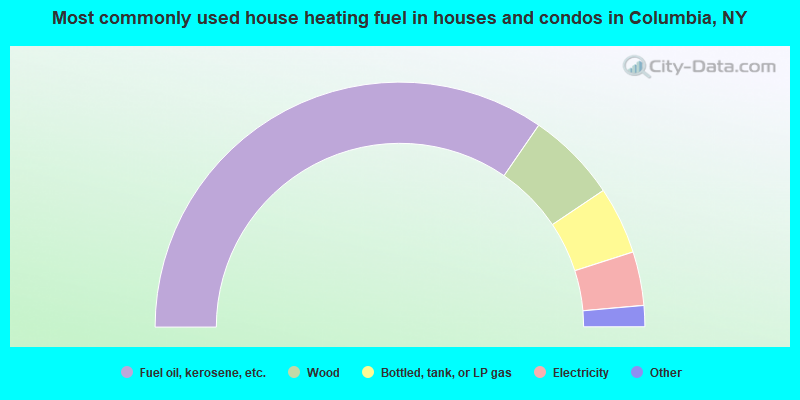
- 69.2%Fuel oil, kerosene, etc.
- 12.0%Wood
- 8.9%Bottled, tank, or LP gas
- 7.1%Electricity
- 1.8%Other fuel
- 0.6%Utility gas
- 0.4%Coal or coke
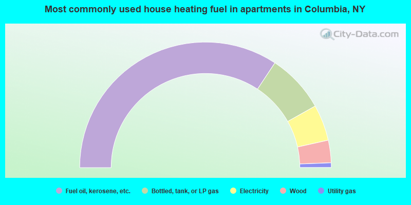
- 68.6%Fuel oil, kerosene, etc.
- 15.1%Bottled, tank, or LP gas
- 9.3%Electricity
- 5.8%Wood
- 1.2%Utility gas
Columbia compared to New York state average:
- Median house value significantly below state average.
- Unemployed percentage below state average.
- Black race population percentage significantly below state average.
- Hispanic race population percentage significantly below state average.
- Foreign-born population percentage significantly below state average.
- Renting percentage significantly below state average.
- Length of stay since moving in significantly above state average.
- Number of rooms per house significantly below state average.
- House age significantly below state average.
- Percentage of population with a bachelor's degree or higher below state average.