Chebeague Island, Maine
Submit your own pictures of this town and show them to the world
- OSM Map
- Google Map
- MSN Map
| Males: 165 | |
| Females: 176 |
| Median resident age: | 57.9 years |
| Maine median age: | 43.0 years |
| Chebeague Island: | $89,345 |
| ME: | $69,543 |
Estimated per capita income in 2022: $55,069
Chebeague Island town income, earnings, and wages data
Estimated median house or condo value in 2022: $442,300
| Chebeague Island: | $442,300 |
| ME: | $290,600 |
Mean prices in 2022: all housing units: $514,200; detached houses: $533,395; townhouses or other attached units: $572,947; in 2-unit structures: $538,406; in 3-to-4-unit structures: $462,507; in 5-or-more-unit structures: $450,834; mobile homes: $93,551
Detailed information about poverty and poor residents in Chebeague Island, ME
Compare current foreclosures in Chebeague Island, ME:
| Photo | Address | Area | Beds / Baths | Price | Details |
|---|---|---|---|---|---|

|
#1
Meeting House Ln
Chebeague Island, ME 04017
|
1,176 sq. feet
|
1 baths 2 beds |
show details | |

|
Check over 1 million property listings on Foreclosure.com!
|
browse all offers | |||

- 33899.1%White alone
- 10.3%Black alone
- 10.3%Asian alone
- 10.3%Two or more races

 Recent articles from our blog. Our writers, many of them Ph.D. graduates or candidates, create easy-to-read articles on a wide variety of topics.
Chebeague Island, ME City Guides:
Current Local Time: EST time zone
Elevation: 60 feet
Nearest city with pop. 50,000+: Portland, ME  (9.6 miles , pop. 64,249).
Nearest city with pop. 200,000+: Boston, MA (110.0 miles , pop. 589,141).
Nearest city with pop. 1,000,000+: Bronx, NY (277.7 miles , pop. 1,332,650).
Nearest cities:
), ), ), )Latitude: 43.74 N, Longitude: 70.11 W
Area code commonly used in this area: 207
Single-family new house construction building permits:
- 2022: 4 buildings, average cost: $400,000
- 2021: 3 buildings, average cost: $133,300
- 2020: 2 buildings, average cost: $250,000
- 2019: 4 buildings, average cost: $237,500
- 2017: 4 buildings, average cost: $216,300
- 2015: 4 buildings, average cost: $283,200
- 2014: 4 buildings, average cost: $195,000
- 2013: 1 building, cost: $350,000
- 2012: 1 building, cost: $350,000
- 2011: 3 buildings, average cost: $350,000
- 2010: 1 building, cost: $350,000
- 2008: 2 buildings, average cost: $225,000


| Here: | 3.6% |
| Maine: | 3.4% |
(lower is better)

Air Quality Index (AQI) level in 2023 was 70.7. This is about average.
| City: | 70.7 |
| U.S.: | 72.6 |

Carbon Monoxide (CO) [ppm] level in 2021 was 0.192. This is better than average. Closest monitor was 9.7 miles away from the city center.
| City: | 0.192 |
| U.S.: | 0.251 |

Nitrogen Dioxide (NO2) [ppb] level in 2023 was 5.47. This is about average. Closest monitor was 9.4 miles away from the city center.
| City: | 5.47 |
| U.S.: | 5.11 |

Sulfur Dioxide (SO2) [ppb] level in 2020 was 0.222. This is significantly better than average. Closest monitor was 1.9 miles away from the city center.
| City: | 0.222 |
| U.S.: | 1.515 |

Ozone [ppb] level in 2023 was 29.9. This is about average. Closest monitor was 9.4 miles away from the city center.
| City: | 29.9 |
| U.S.: | 33.3 |


Particulate Matter (PM2.5) [µg/m3] level in 2023 was 6.48. This is better than average. Closest monitor was 8.6 miles away from the city center.
| City: | 6.48 |
| U.S.: | 8.11 |
Earthquake activity:
Chebeague Island-area historical earthquake activity is significantly above Maine state average. It is 75% smaller than the overall U.S. average.On 10/16/2012 at 23:12:25, a magnitude 4.7 (4.7 ML, Depth: 10.0 mi, Class: Light, Intensity: IV - V) earthquake occurred 29.1 miles away from the city center
On 4/20/2002 at 10:50:47, a magnitude 5.3 (5.3 ML, Depth: 3.0 mi, Class: Moderate, Intensity: VI - VII) earthquake occurred 186.0 miles away from Chebeague Island center
On 1/19/1982 at 00:14:42, a magnitude 4.7 (4.5 MB, 4.7 MD, 4.5 LG) earthquake occurred 76.5 miles away from Chebeague Island center
On 4/20/2002 at 10:50:47, a magnitude 5.2 (5.2 MB, 4.2 MS, 5.2 MW, 5.0 MW) earthquake occurred 186.5 miles away from the city center
On 10/7/1983 at 10:18:46, a magnitude 5.3 (5.1 MB, 5.3 LG, 5.1 ML) earthquake occurred 211.7 miles away from Chebeague Island center
On 2/26/1999 at 03:38:43, a magnitude 3.8 (3.8 LG, Depth: 2.0 mi, Class: Light, Intensity: II - III) earthquake occurred 58.9 miles away from Chebeague Island center
Magnitude types: regional Lg-wave magnitude (LG), body-wave magnitude (MB), duration magnitude (MD), local magnitude (ML), surface-wave magnitude (MS), moment magnitude (MW)
Natural disasters:
The number of natural disasters in Cumberland County (33) is a lot greater than the US average (15).Major Disasters (Presidential) Declared: 22
Emergencies Declared: 10
Causes of natural disasters: Floods: 19, Storms: 13, Snows: 7, Winter Storms: 6, Heavy Rains: 3, Hurricanes: 3, Winds: 3, Blizzard: 1, Ice Storm: 1, Mudslide: 1, Snowfall: 1, Snowstorm: 1, Tornado: 1, Other: 2 (Note: some incidents may be assigned to more than one category).
Hospitals and medical centers near Chebeague Island:
- BRENTWOOD REHAB AND NURSING CENTER (Nursing Home, about 6 miles away; YARMOUTH, ME)
- FALMOUTH BY THE SEA (Nursing Home, about 6 miles away; FALMOUTH, ME)
- SEDGEWOOD COMMONS (Nursing Home, about 6 miles away; FALMOUTH, ME)
- FREEPORT NURSING AND REHAB CENTER (Nursing Home, about 9 miles away; FREEPORT, ME)
- SEASIDE REHAB AND HEALTH CARE (Nursing Home, about 9 miles away; PORTLAND, ME)
- CHS - HOSPICE (Hospital, about 9 miles away; PORTLAND, ME)
- BETTER HEALTH CARE INC (Home Health Center, about 10 miles away; PORTLAND, ME)
Colleges/universities with over 2000 students nearest to Chebeague Island:
- Southern Maine Community College (about 9 miles; South Portland, ME; Full-time enrollment: 4,666)
- University of Southern Maine (about 10 miles; Portland, ME; FT enrollment: 6,647)
- Saint Joseph's College of Maine (about 20 miles; Standish, ME; FT enrollment: 2,010)
- University of New England (about 24 miles; Biddeford, ME; FT enrollment: 4,539)
- University of Maine at Augusta (about 45 miles; Augusta, ME; FT enrollment: 3,204)
- University of New Hampshire-Main Campus (about 59 miles; Durham, NH; FT enrollment: 15,243)
- University of Maine at Farmington (about 65 miles; Farmington, ME; FT enrollment: 2,036)
Public elementary/middle school in Chebeague Island:
- CHEBEAGUE ISLAND SCHOOL (Students: 20, Location: 14 SCHOOL HOUSE ROAD, Grades: PK-5)
Drinking water stations with addresses in Chebeague Island and their reported violations in the past:
SLOW BELL CAFE (Population served: 200, Groundwater):Past monitoring violations:CHEBEAGUE RECREATION CENTER (Population served: 25, Groundwater):
- 17 routine major monitoring violations
- 3 regular monitoring violations
Past monitoring violations:
- 4 routine major monitoring violations
| This town: | 2.0 people |
| Maine: | 2.3 people |
| This town: | 57.3% |
| Whole state: | 62.9% |
| This town: | 5.3% |
| Whole state: | 9.4% |
Likely homosexual households (counted as self-reported same-sex unmarried-partner households)
- Lesbian couples: 0.0% of all households
- Gay men: 1.2% of all households
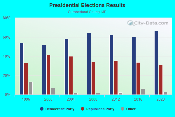
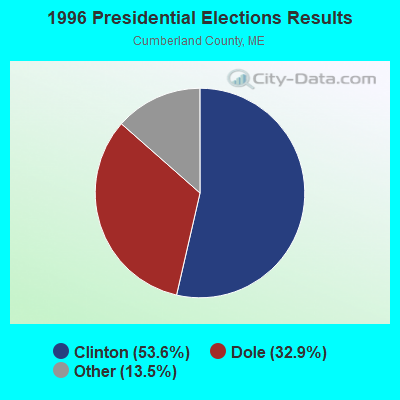
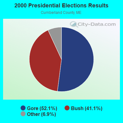


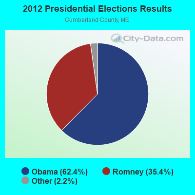


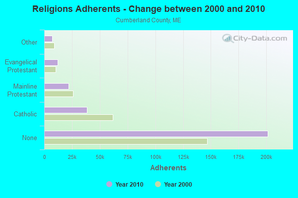
Graphs represent county-level data. Detailed 2008 Election Results
Political contributions by individuals in Chebeague Island, ME
Religion statistics for Chebeague Island, ME (based on Cumberland County data)
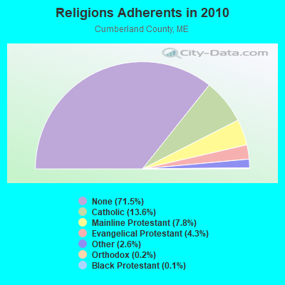
| Religion | Adherents | Congregations |
|---|---|---|
| Catholic | 38,243 | 19 |
| Mainline Protestant | 22,030 | 96 |
| Evangelical Protestant | 12,007 | 85 |
| Other | 7,187 | 44 |
| Orthodox | 500 | 1 |
| Black Protestant | 285 | 2 |
| None | 201,422 | - |
Food Environment Statistics:
| Cumberland County: | 2.62 / 10,000 pop. |
| Maine: | 2.80 / 10,000 pop. |
| This county: | 0.11 / 10,000 pop. |
| Maine: | 0.14 / 10,000 pop. |
| This county: | 2.44 / 10,000 pop. |
| State: | 2.20 / 10,000 pop. |
| Cumberland County: | 3.82 / 10,000 pop. |
| Maine: | 5.75 / 10,000 pop. |
| This county: | 12.01 / 10,000 pop. |
| Maine: | 11.02 / 10,000 pop. |
| This county: | 7.1% |
| Maine: | 8.2% |
| Cumberland County: | 19.5% |
| State: | 25.0% |
Strongest AM radio stations in Chebeague Island:
- WGAN (560 AM; 5 kW; PORTLAND, ME; Owner: SAGA COMMUNICATIONS OF NEW ENGLAND, LLC)
- WMTW (870 AM; 10 kW; GORHAM, ME; Owner: RADIO PARTNERS OF MAINE, L.P.)
- WLOB (1310 AM; 5 kW; PORTLAND, ME; Owner: ATLANTIC COAST RADIO, LLC)
- WZAN (970 AM; 5 kW; PORTLAND, ME; Owner: SAGA COMMUNICATIONS OF NEW ENGLAND, LLC)
- WJAE (1440 AM; 5 kW; WESTBROOK, ME; Owner: ALTANTIC COAST RADIO, LLC)
- WBAE (1490 AM; 1 kW; PORTLAND, ME; Owner: SAGA COMMUNICATIONS OF NEW ENGLAND, LLC)
- WRKO (680 AM; 50 kW; BOSTON, MA; Owner: ENTERCOM BOSTON LICENSE, LLC)
- WLAM (1470 AM; 5 kW; LEWISTON, ME; Owner: RADIO PARTNERS OF MAINE, L.P.)
- WJJB (900 AM; 1 kW; BRUNSWICK, ME; Owner: ATLANTIC COAST RADIO, LLC)
- WJTO (730 AM; 1 kW; BATH, ME; Owner: BLUE JEY BROADCASTING COMPANY)
- WEEI (850 AM; 50 kW; BOSTON, MA; Owner: ENTERCOM BOSTON LICENSE, LLC)
- WBZ (1030 AM; 50 kW; BOSTON, MA; Owner: INFINITY BROADCASTING OPERATIONS, INC.)
- WGIN (930 AM; 10 kW; ROCHESTER, NH; Owner: CAPSTAR TX LIMITED PARTNERSHIP)
Strongest FM radio stations in Chebeague Island:
- WYNZ (100.9 FM; WESTBROOK, ME; Owner: SAGA COMMUNICATIONS OF NEW ENGLAND, LLC)
- WYFP (91.9 FM; HARPSWELL, ME; Owner: BIBLE BROADCASTING NETWORK, INC.)
- WJBQ (97.9 FM; PORTLAND, ME; Owner: CITADEL BROADCASTING COMPANY)
- WMGX (93.1 FM; PORTLAND, ME; Owner: SAGA COMMUNICATIONS OF NEW ENGLAND, LLC)
- WPOR (101.9 FM; PORTLAND, ME; Owner: SAGA COMMUNICATIONS OF NEW ENGLAND, LLC)
- WBLM (102.9 FM; PORTLAND, ME; Owner: CITADEL BROADCASTING COMPANY)
- WMSJ (89.3 FM; FREEPORT, ME; Owner: DOWNEAST CHRISTIAN COMMUNICATIONS)
- WTHT (107.5 FM; LEWISTON, ME; Owner: RADIO PARTNERS OF MAINE, L.P.)
- WMTW-FM (106.7 FM; NORTH WINDHAM, ME; Owner: RADIO PARTNERS OF MAINE, L.P.)
- WMEA (90.1 FM; PORTLAND, ME; Owner: MAINE PUBLIC BROADCASTING CORPORATION)
- WJJB-FM (95.5 FM; TOPSHAM, ME; Owner: ATLANTIC COAST RADIO, LLC)
- WCLZ (98.9 FM; BRUNSWICK, ME; Owner: CITADEL BROADCASTING COMPANY)
- WMEK-FM (99.9 FM; AUBURN, ME; Owner: RADIO PARTNERS OF MAINE, L.P.)
- WPKQ (103.7 FM; NORTH CONWAY, NH; Owner: CITADEL BROADCASTING COMPANY)
- WHOM (94.9 FM; MT. WASHINGTON, NH; Owner: CITADEL BROADCASTING COMPANY)
- WYAR (88.3 FM; YARMOUTH, ME; Owner: HERITAGE RADIO SOCIETY, INC.)
- W245AA (96.9 FM; PORTLAND, ME; Owner: RADIO PARTNERS OF MAINE, L.P.)
- WSCY (106.9 FM; MOULTONBOROUGH, NH; Owner: NORTHEAST COMMUNICATIONS CORPORATION)
- WCYY (94.3 FM; BIDDEFORD, ME; Owner: CITADEL BROADCASTING COMPANY)
- WRED (95.9 FM; SACO, ME; Owner: ATLANTIC COAST RADIO, LLC)
TV broadcast stations around Chebeague Island:
- WGME-TV (Channel 13; PORTLAND, ME; Owner: WGME LICENSEE, LLC)
- WPXT (Channel 51; PORTLAND, ME; Owner: HMW, INC.)
- WPME (Channel 35; LEWISTON, ME; Owner: KB PRIME MEDIA LLC)
- W32CA (Channel 32; PORTLAND, ME; Owner: NATIONAL MINORITY T.V., INC.)
- WMTW-TV (Channel 8; POLAND SPRING, ME; Owner: WMTW BROADCAST GROUP, LLC)
- WCSH (Channel 6; PORTLAND, ME; Owner: PACIFIC AND SOUTHERN COMPANY, INC.)
- WMEA-TV (Channel 26; BIDDEFORD, ME; Owner: MAINE PUBLIC BROADCASTING CORP.)
- W58CM (Channel 58; BANGOR, ME; Owner: MS COMMUNICATIONS, LLC)
- W57AP (Channel 57; FALMOUTH, ME; Owner: SHERWOOD H. CRAIG)
- WPFO (Channel 23; WATERVILLE, ME; Owner: CMCG PORTLAND LICENSE LLC)
- WCBB (Channel 10; AUGUSTA, ME; Owner: MAINE PUBLIC BROADCASTING CORP.)
- WLLB-LP (Channel 15; PORTLAND, ME; Owner: CARTER BROADCASTING CORPORATION)
Chebeague Island fatal accident list:
Jun 8, 1997 01:15 AM, Northroad, Vehicles: 2, Persons: 6, Fatalities: 1, Drunk persons involved: 1
FCC Registered Broadcast Land Mobile Towers:
1- Firehouse Rd (Lat: 43.745917 Lon: -70.110611), Call Sign: KNCD890,
Assigned Frequencies: 154.010 MHz, 154.310 MHz, Grant Date: 10/24/1996, Expiration Date: 12/24/2001, Cancellation Date: 05/05/2002, Registrant: Cumberland, Town Of, Cumberland Center, ME 04021, Phone: (207) 829-5421
FCC Registered Microwave Towers:
1- CHBG Island, Lat: 43.722222 Lon: -70.134444, Type: Building, Structure height: 3 m, Call Sign: WQRE839,
Assigned Frequencies: 3650.00 MHz, Grant Date: 04/30/2013, Expiration Date: 04/30/2023, Cancellation Date: 05/08/2023, Certifier: David Hill, Registrant: Axiom Technologies, 3 Water Street, Machias, ME 04654, Phone: (207) 255-0679, Email:
FCC Registered Amateur Radio Licenses:
4- Call Sign: K1VOG, Licensee ID: L00948113, Grant Date: 10/30/2014, Expiration Date: 01/26/2025, Certifier: Nelson D Stevens, Registrant: Nelson D Stevens, 278 South Rd, Chebeague Island, ME 04017-3204
- Call Sign: NX1I, Licensee ID: L01436423, Grant Date: 01/30/2019, Expiration Date: 03/16/2029, Certifier: William F Armstrong, Registrant: William F Armstrong, John Small Road, Chebeague Island, ME 04017
- Call Sign: W1KRH, Grant Date: 02/15/1996, Expiration Date: 02/15/2006, Cancellation Date: 02/16/2008, Registrant: Madeline L Craven, Rr Box 590, Chebeague Island, ME 04017
- Call Sign: NP2PN, Licensee ID: L01785080, Grant Date: 01/31/2023, Expiration Date: 04/30/2033, Certifier: Steven J Williams, Registrant: Steven J Williams, 17 Littlefield Road, Chebeague Island, ME 04017
Chebeague Island compared to Maine state average:
- Median house value above state average.
- Unemployed percentage significantly below state average.
- Black race population percentage significantly below state average.
- Hispanic race population percentage significantly below state average.
- Median age significantly above state average.
- Foreign-born population percentage significantly below state average.
- Renting percentage below state average.
- Length of stay since moving in significantly above state average.
- Number of rooms per house significantly below state average.
- House age significantly below state average.
- Number of college students significantly below state average.
- Percentage of population with a bachelor's degree or higher significantly below state average.