Burlington, Maine
Submit your own pictures of this town and show them to the world
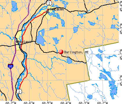
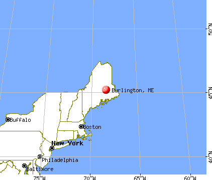
- OSM Map
- General Map
- Google Map
- MSN Map
Population change since 2000: +3.4%
 |
| Males: 183 | |
| Females: 180 |
| Median resident age: | 50.0 years |
| Maine median age: | 43.0 years |
Zip codes: 04417.
| Burlington: | $50,724 |
| ME: | $69,543 |
Estimated per capita income in 2022: $23,265 (it was $11,573 in 2000)
Burlington town income, earnings, and wages data
Estimated median house or condo value in 2022: $117,613 (it was $45,200 in 2000)
| Burlington: | $117,613 |
| ME: | $290,600 |
Mean prices in 2022: all housing units: $235,563; detached houses: $252,705; townhouses or other attached units: $267,749; in 2-unit structures: $255,332; in 3-to-4-unit structures: $815,300; in 5-or-more-unit structures: $185,873; mobile homes: $93,017; occupied boats, rvs, vans, etc.: $21,333
Detailed information about poverty and poor residents in Burlington, ME


- 36099.2%White alone
- 10.3%Asian alone
- 10.3%Two or more races
- 10.3%Hispanic

Races in Burlington detailed stats: ancestries, foreign born residents, place of birth
 Recent articles from our blog. Our writers, many of them Ph.D. graduates or candidates, create easy-to-read articles on a wide variety of topics.

 | Bangor vs Burlington VT (16 replies) |
| Portland or Nashua or Burlington oh my! (6 replies) |
| Thinking of a move to Portland or nearby Portland (20 replies) |
| Maine weather thread (3207 replies) |
| What is Burlington like? (2 replies) |
| Portland vs. Burlington (2 replies) |
Latest news from Burlington, ME collected exclusively by city-data.com from local newspapers, TV, and radio stations
Ancestries: English (23.6%), United States (11.4%), French (11.1%), Irish (10.0%), French Canadian (8.5%), Scottish (6.0%).
Current Local Time: EST time zone
Incorporated on 03/08/1832
Elevation: 523 feet
Land area: 53.8 square miles.
Population density: 6.7 people per square mile (very low).
5 residents are foreign born
| This town: | 1.4% |
| Maine: | 2.9% |
| Burlington town: | 1.4% ($614) |
| Maine: | 1.5% ($1,417) |
Nearest city with pop. 50,000+: Portland, ME  (146.2 miles , pop. 64,249).
Nearest city with pop. 200,000+: Boston, MA (246.0 miles , pop. 589,141).
Nearest city with pop. 1,000,000+: Bronx, NY (414.1 miles , pop. 1,332,650).
Nearest cities:
), ), ), ), Latitude: 45.29 N, Longitude: 68.38 W
Area code commonly used in this area: 207

Single-family new house construction building permits:
- 2022: 14 buildings, average cost: $236,300
- 2021: 14 buildings, average cost: $259,200
- 2020: 15 buildings, average cost: $178,900
- 2019: 15 buildings, average cost: $178,900
- 2018: 15 buildings, average cost: $178,900
- 2017: 15 buildings, average cost: $178,900
- 2016: 16 buildings, average cost: $178,900
- 2015: 15 buildings, average cost: $178,900
- 2014: 18 buildings, average cost: $178,900
- 2013: 13 buildings, average cost: $178,900
- 2012: 13 buildings, average cost: $178,900
- 2011: 12 buildings, average cost: $178,900
- 2010: 17 buildings, average cost: $178,900
- 2009: 18 buildings, average cost: $178,900
- 2007: 2 buildings, average cost: $80,000
- 2005: 21 buildings, average cost: $18,600
- 2004: 17 buildings, average cost: $23,200
- 2003: 7 buildings, average cost: $20,000


| Here: | 9.8% |
| Maine: | 3.4% |
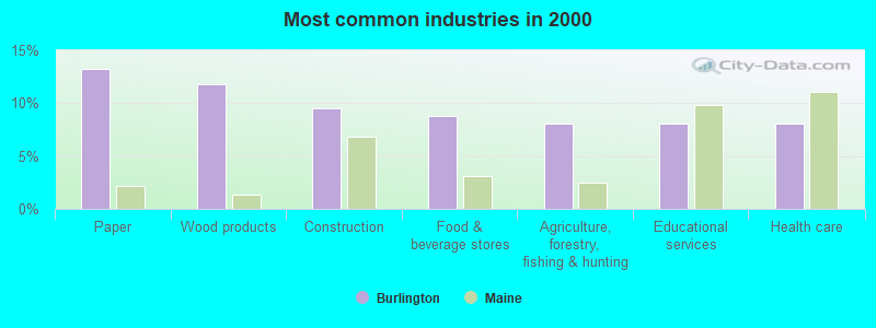
- Paper (13.2%)
- Wood products (11.8%)
- Construction (9.6%)
- Food & beverage stores (8.8%)
- Agriculture, forestry, fishing & hunting (8.1%)
- Educational services (8.1%)
- Health care (8.1%)
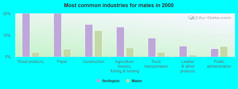
- Wood products (20.0%)
- Paper (20.0%)
- Construction (15.0%)
- Agriculture, forestry, fishing & hunting (13.8%)
- Truck transportation (8.8%)
- Leather & allied products (5.0%)
- Public administration (3.8%)
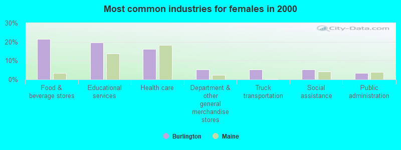
- Food & beverage stores (21.4%)
- Educational services (19.6%)
- Health care (16.1%)
- Department & other general merchandise stores (5.4%)
- Truck transportation (5.4%)
- Social assistance (5.4%)
- Public administration (3.6%)

- Driver/sales workers and truck drivers (10.3%)
- Other production occupations, including supervisors (9.6%)
- Woodworkers (7.4%)
- Electrical equipment mechanics and other installation, maintenance, and repair workers, including supervisors (6.6%)
- Laborers and material movers, hand (5.1%)
- Cashiers (4.4%)
- Preschool, kindergarten, elementary, and middle school teachers (3.7%)

- Other production occupations, including supervisors (16.2%)
- Driver/sales workers and truck drivers (16.2%)
- Woodworkers (12.5%)
- Electrical equipment mechanics and other installation, maintenance, and repair workers, including supervisors (11.2%)
- Laborers and material movers, hand (6.2%)
- Fishing, hunting, and forestry occupations (5.0%)
- Carpenters (5.0%)
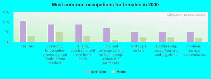
- Cashiers (10.7%)
- Preschool, kindergarten, elementary, and middle school teachers (8.9%)
- Nursing, psychiatric, and home health aides (8.9%)
- Food and beverage serving workers, except waiters and waitresses (7.1%)
- Child care workers (5.4%)
- Bookkeeping, accounting, and auditing clerks (5.4%)
- Customer service representatives (5.4%)
Average climate in Burlington, Maine
Based on data reported by over 4,000 weather stations


Earthquake activity:
Burlington-area historical earthquake activity is significantly above Maine state average. It is 83% smaller than the overall U.S. average.On 4/20/2002 at 10:50:47, a magnitude 5.3 (5.3 ML, Depth: 3.0 mi, Class: Moderate, Intensity: VI - VII) earthquake occurred 266.1 miles away from the city center
On 10/16/2012 at 23:12:25, a magnitude 4.7 (4.7 ML, Depth: 10.0 mi, Class: Light, Intensity: IV - V) earthquake occurred 162.5 miles away from the city center
On 4/20/2002 at 10:50:47, a magnitude 5.2 (5.2 MB, 4.2 MS, 5.2 MW, 5.0 MW) earthquake occurred 267.5 miles away from the city center
On 10/7/1983 at 10:18:46, a magnitude 5.3 (5.1 MB, 5.3 LG, 5.1 ML) earthquake occurred 307.8 miles away from Burlington center
On 1/19/1982 at 00:14:42, a magnitude 4.7 (4.5 MB, 4.7 MD, 4.5 LG) earthquake occurred 201.8 miles away from the city center
On 9/16/1994 at 04:22:42, a magnitude 3.6 (3.6 LG, Depth: 3.1 mi, Class: Light, Intensity: II - III) earthquake occurred 7.5 miles away from Burlington center
Magnitude types: regional Lg-wave magnitude (LG), body-wave magnitude (MB), duration magnitude (MD), local magnitude (ML), surface-wave magnitude (MS), moment magnitude (MW)
Natural disasters:
The number of natural disasters in Penobscot County (19) is greater than the US average (15).Major Disasters (Presidential) Declared: 11
Emergencies Declared: 7
Causes of natural disasters: Floods: 9, Storms: 8, Snows: 5, Heavy Rains: 2, Blizzard: 1, Hurricane: 1, Ice Storm: 1, Snowfall: 1, Wind: 1, Winter Storm: 1, Other: 2 (Note: some incidents may be assigned to more than one category).
Colleges/universities with over 2000 students nearest to Burlington:
- University of Maine (about 31 miles; Orono, ME; Full-time enrollment: 8,931)
- Husson University (about 38 miles; Bangor, ME; FT enrollment: 2,421)
- University of Maine at Augusta (about 96 miles; Augusta, ME; FT enrollment: 3,204)
- University of Maine at Farmington (about 97 miles; Farmington, ME; FT enrollment: 2,036)
- Saint Joseph's College of Maine (about 146 miles; Standish, ME; FT enrollment: 2,010)
- Southern Maine Community College (about 146 miles; South Portland, ME; FT enrollment: 4,666)
- University of Southern Maine (about 147 miles; Portland, ME; FT enrollment: 6,647)
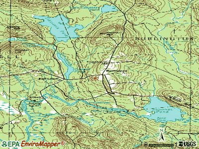
Points of interest:
Notable location: Old Tavern (A). Display/hide its location on the map
Cemeteries: Mount Repose Cemetery (1), Turner Cemetery (2), Page Cemetery (3), Long Ridge Cemetery (4). Display/hide their locations on the map
Lakes and swamps: Little Eskutassis Pond (A), Madagascal Pond (B), Oaks Bog (C). Display/hide their locations on the map
Streams, rivers, and creeks: Thompson Brook (A), Oaks Bog Brook (B), Coffin Brook (C), Bowers Brook (D), Bear Brook (E). Display/hide their locations on the map
| This town: | 2.2 people |
| Maine: | 2.3 people |
| This town: | 63.9% |
| Whole state: | 62.9% |
| This town: | 7.2% |
| Whole state: | 9.4% |
No gay or lesbian households reported
| This town: | 10.9% |
| Whole state: | 10.9% |
| This town: | 3.4% |
| Whole state: | 4.1% |
For population 15 years and over in Burlington:

- Never married: 22.2%
- Now married: 65.7%
- Separated: 0.0%
- Widowed: 3.9%
- Divorced: 8.2%
For population 25 years and over in Burlington:
- High school or higher: 73.5%
- Bachelor's degree or higher: 3.8%
- Graduate or professional degree: 1.5%
- Unemployed: 8.7%
- Mean travel time to work (commute): 35.0 minutes


| Here: | 10.2 |
| Maine average: | 11.2 |


Graphs represent county-level data. Detailed 2008 Election Results
Religion statistics for Burlington, ME (based on Penobscot County data)


| Religion | Adherents | Congregations |
|---|---|---|
| Catholic | 16,581 | 15 |
| Mainline Protestant | 9,715 | 59 |
| Evangelical Protestant | 7,523 | 80 |
| Other | 2,936 | 22 |
| Orthodox | 300 | 1 |
| None | 116,868 | - |
Food Environment Statistics:
| Here: | 2.29 / 10,000 pop. |
| Maine: | 2.80 / 10,000 pop. |
| This county: | 0.13 / 10,000 pop. |
| Maine: | 0.14 / 10,000 pop. |
| Penobscot County: | 2.56 / 10,000 pop. |
| State: | 2.20 / 10,000 pop. |
| Penobscot County: | 5.72 / 10,000 pop. |
| Maine: | 5.75 / 10,000 pop. |
| Penobscot County: | 7.41 / 10,000 pop. |
| Maine: | 11.02 / 10,000 pop. |
| Penobscot County: | 9.0% |
| State: | 8.2% |
| Penobscot County: | 28.0% |
| Maine: | 25.0% |
Strongest AM radio stations in Burlington:
- WZON (620 AM; 5 kW; BANGOR, ME; Owner: THE ZONE CORPORATION)
- WABI (910 AM; 5 kW; BANGOR, ME; Owner: CLEAR CHANNEL BROADCASTING LICENSES, INC.)
- WSKW (1160 AM; 10 kW; SKOWHEGAN, ME; Owner: MOUNTAIN WIRELESS, INCORPORATED)
- WRKO (680 AM; 50 kW; BOSTON, MA; Owner: ENTERCOM BOSTON LICENSE, LLC)
- WDEA (1370 AM; 5 kW; ELLSWORTH, ME; Owner: CUMULUS LICENSING CORP.)
- WREM (710 AM; daytime; 5 kW; MONTICELLO, ME; Owner: ALLAN H WEINER)
- WEEI (850 AM; 50 kW; BOSTON, MA; Owner: ENTERCOM BOSTON LICENSE, LLC)
- WTME (780 AM; 10 kW; RUMFORD, ME; Owner: MOUNTAIN VALLEY BROADCASTING, INC.)
- WSYY (1240 AM; 1 kW; MILLINOCKET, ME; Owner: KATAHDIN BROADCASTING, INC.)
- WBZ (1030 AM; 50 kW; BOSTON, MA; Owner: INFINITY BROADCASTING OPERATIONS, INC.)
- WNNZ (640 AM; 50 kW; WESTFIELD, MA; Owner: CLEAR CHANNEL BROADCASTING LICENSES, INC.)
- WCRN (830 AM; 50 kW; WORCESTER, MA; Owner: CARTER BROADCASTING CORPORATION)
- WCHP (760 AM; 35 kW; CHAMPLAIN, NY; Owner: CHAMPLAIN RADIO, INC.)
Strongest FM radio stations in Burlington:
- WHCF (88.5 FM; BANGOR, ME; Owner: BANGOR BAPTIST CHURCH)
- WVOM (103.9 FM; HOWLAND, ME; Owner: CLEAR CHANNEL BROADCASTING LICENSES, INC.)
- WHMX (105.7 FM; LINCOLN, ME; Owner: BANGOR BAPTIST CHURCH)
- WQCB (106.5 FM; BREWER, ME; Owner: CUMULUS LICENSING CORP.)
- WBZN (107.3 FM; OLD TOWN, ME; Owner: CUMULUS LICENSING CORP.)
- WMEH (90.9 FM; BANGOR, ME; Owner: MAINE PUBLIC BROADCASTING CORPORATION)
- WWMJ (95.7 FM; ELLSWORTH, ME; Owner: CUMULUS LICENSING CORP.)
- WEZQ (92.9 FM; BANGOR, ME; Owner: CUMULUS LICENSING CORP.)
- WSYY-FM (94.9 FM; MILLINOCKET, ME; Owner: KATAHDIN COMMUNICATIONS, INC.)
TV broadcast stations around Burlington:
- W34CN (Channel 34; MEDWAY, ME; Owner: TRINITY BROADCASTING NETWORK)
- National Bridge Inventory (NBI) Statistics
- 1Number of bridges
- 3ft / 0.7mTotal length
- 492Total average daily traffic
- 24Total average daily truck traffic
- 787Total future (year 2036) average daily traffic

- 68.5%Fuel oil, kerosene, etc.
- 24.2%Wood
- 5.6%Bottled, tank, or LP gas
- 1.6%Electricity

- 44.4%Fuel oil, kerosene, etc.
- 38.9%Wood
- 16.7%Bottled, tank, or LP gas
Burlington compared to Maine state average:
- Median house value significantly below state average.
- Black race population percentage significantly below state average.
- Hispanic race population percentage significantly below state average.
- Median age above state average.
- Foreign-born population percentage significantly below state average.
- Renting percentage significantly below state average.
- Length of stay since moving in significantly above state average.
- Number of rooms per house significantly below state average.
- House age significantly below state average.
- Percentage of population with a bachelor's degree or higher significantly below state average.