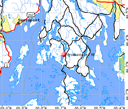
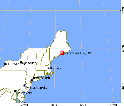
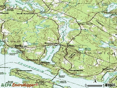
Brooksville, Maine

Brooksville: Fog is burning off in Bucks Harbor

Brooksville: Bucks Harbor

Brooksville: The bay
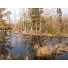
Brooksville: Smelt houses on the bagaduceriver,,,,,,,Beaver flowage at Herick heights
- add
your
Submit your own pictures of this town and show them to the world
- OSM Map
- General Map
- Google Map
- MSN Map
Population change since 2000: +2.5%
 |
| Males: 448 | |
| Females: 486 |
| Median resident age: | 53.0 years |
| Maine median age: | 43.0 years |
Zip codes: 04617.
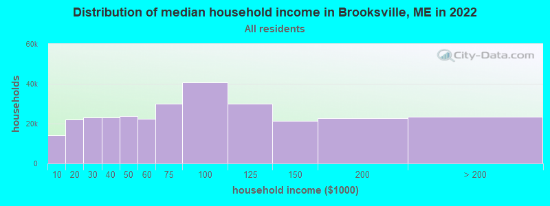
| Brooksville: | $66,544 |
| ME: | $69,543 |
Estimated per capita income in 2022: $47,847 (it was $23,565 in 2000)
Brooksville town income, earnings, and wages data
Estimated median house or condo value in 2022: $357,982 (it was $125,000 in 2000)
| Brooksville: | $357,982 |
| ME: | $290,600 |
Mean prices in 2022: all housing units: $379,336; detached houses: $396,802; townhouses or other attached units: $600,716; in 2-unit structures: $274,479; in 3-to-4-unit structures: $212,346; in 5-or-more-unit structures: $146,369; mobile homes: $158,183; occupied boats, rvs, vans, etc.: $16,454
Detailed information about poverty and poor residents in Brooksville, ME


- 89195.4%White alone
- 181.9%Asian alone
- 111.2%Two or more races
- 101.1%Hispanic
- 20.2%American Indian alone
- 20.2%Other race alone
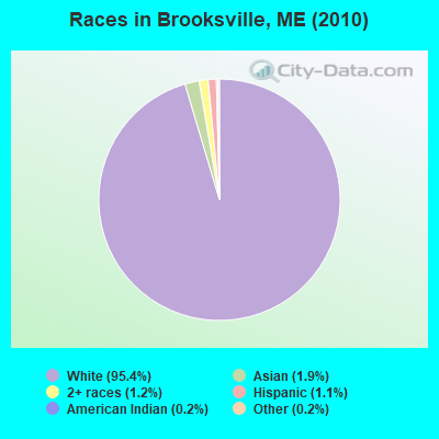
Races in Brooksville detailed stats: ancestries, foreign born residents, place of birth
 Recent articles from our blog. Our writers, many of them Ph.D. graduates or candidates, create easy-to-read articles on a wide variety of topics.

 | Snow Removal, firewood, internet - Brooksville (10 replies) |
| Maine weather thread (3207 replies) |
| Blue Hill - midcoast or downeast? (27 replies) |
| Best town for kids (prior military) (12 replies) |
| Acadia National Park is "America's Favorite Place" (13 replies) |
| More wild Turkeys in maine than 10-20 years ago? (39 replies) |
Latest news from Brooksville, ME collected exclusively by city-data.com from local newspapers, TV, and radio stations
Ancestries: English (24.3%), United States (15.7%), Irish (11.5%), Scottish (6.3%), Swedish (4.9%), German (4.8%).
Current Local Time: EST time zone
Incorporated on 06/13/1817
Elevation: 85 feet
Land area: 31.1 square miles.
Population density: 30 people per square mile (very low).
20 residents are foreign born (2.0% Europe).
| This town: | 2.2% |
| Maine: | 2.9% |
| Brooksville town: | 0.6% ($744) |
| Maine: | 1.5% ($1,417) |
Nearest city with pop. 50,000+: Portland, ME  (89.1 miles , pop. 64,249).
Nearest city with pop. 200,000+: Boston, MA (182.9 miles , pop. 589,141).
Nearest city with pop. 1,000,000+: Bronx, NY (355.7 miles , pop. 1,332,650).
Nearest cities:
), ), ), Latitude: 44.35 N, Longitude: 68.75 W
Area code commonly used in this area: 207

| Here: | 3.3% |
| Maine: | 3.4% |
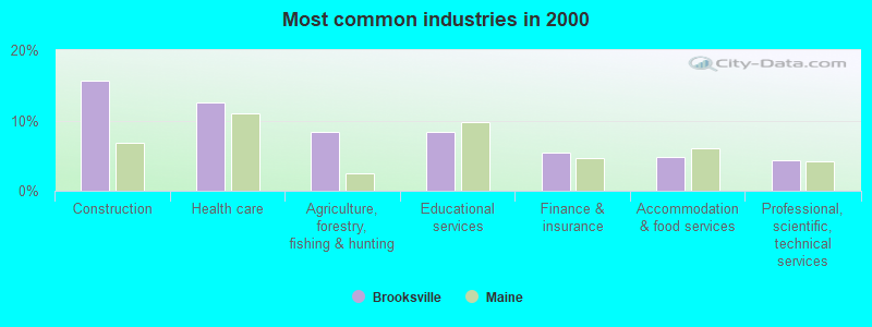
- Construction (15.6%)
- Health care (12.6%)
- Agriculture, forestry, fishing & hunting (8.4%)
- Educational services (8.4%)
- Finance & insurance (5.4%)
- Accommodation & food services (4.8%)
- Professional, scientific, technical services (4.3%)
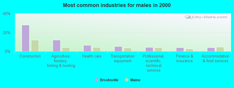
- Construction (27.8%)
- Agriculture, forestry, fishing & hunting (12.2%)
- Health care (6.5%)
- Transportation equipment (5.3%)
- Professional, scientific, technical services (4.5%)
- Finance & insurance (4.1%)
- Accommodation & food services (4.1%)
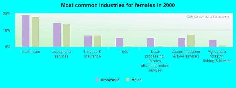
- Health care (19.4%)
- Educational services (14.3%)
- Finance & insurance (6.9%)
- Food (5.5%)
- Data processing, libraries, other information services (5.5%)
- Accommodation & food services (5.5%)
- Agriculture, forestry, fishing & hunting (4.1%)
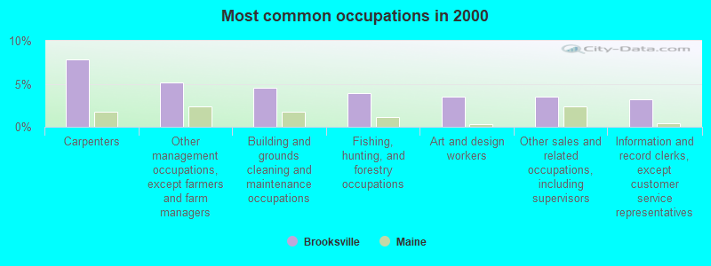
- Carpenters (7.8%)
- Other management occupations, except farmers and farm managers (5.2%)
- Building and grounds cleaning and maintenance occupations (4.5%)
- Fishing, hunting, and forestry occupations (3.9%)
- Art and design workers (3.5%)
- Other sales and related occupations, including supervisors (3.5%)
- Information and record clerks, except customer service representatives (3.2%)
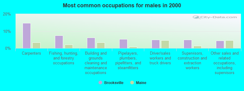
- Carpenters (14.7%)
- Fishing, hunting, and forestry occupations (7.3%)
- Building and grounds cleaning and maintenance occupations (6.1%)
- Pipelayers, plumbers, pipefitters, and steamfitters (5.3%)
- Driver/sales workers and truck drivers (4.9%)
- Supervisors, construction and extraction workers (4.9%)
- Other sales and related occupations, including supervisors (4.5%)

- Other management occupations, except farmers and farm managers (6.5%)
- Information and record clerks, except customer service representatives (6.0%)
- Registered nurses (5.5%)
- Nursing, psychiatric, and home health aides (5.5%)
- Art and design workers (4.6%)
- Counselors, social workers, and other community and social service specialists (4.1%)
- Preschool, kindergarten, elementary, and middle school teachers (4.1%)
Average climate in Brooksville, Maine
Based on data reported by over 4,000 weather stations


(lower is better)
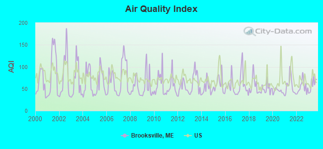
Air Quality Index (AQI) level in 2023 was 59.7. This is better than average.
| City: | 59.7 |
| U.S.: | 72.6 |
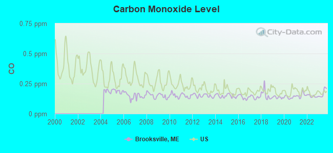
Carbon Monoxide (CO) [ppm] level in 2023 was 0.172. This is significantly better than average. Closest monitor was 22.1 miles away from the city center.
| City: | 0.172 |
| U.S.: | 0.251 |
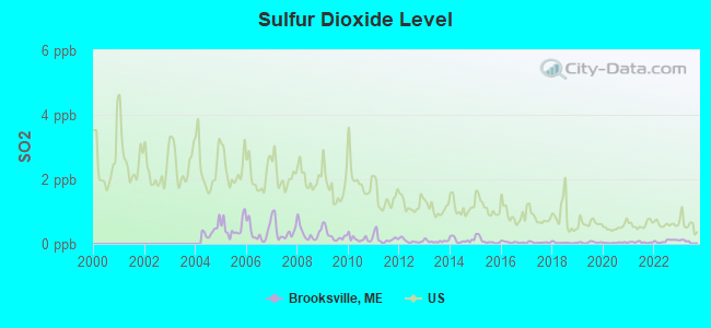
Sulfur Dioxide (SO2) [ppb] level in 2023 was 0.0636. This is significantly better than average. Closest monitor was 9.8 miles away from the city center.
| City: | 0.0636 |
| U.S.: | 1.5147 |
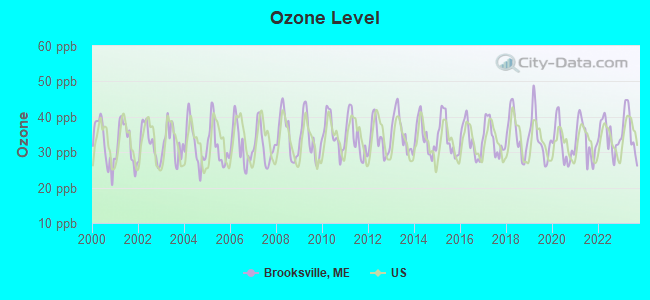
Ozone [ppb] level in 2023 was 36.2. This is about average. Closest monitor was 6.1 miles away from the city center.
| City: | 36.2 |
| U.S.: | 33.3 |

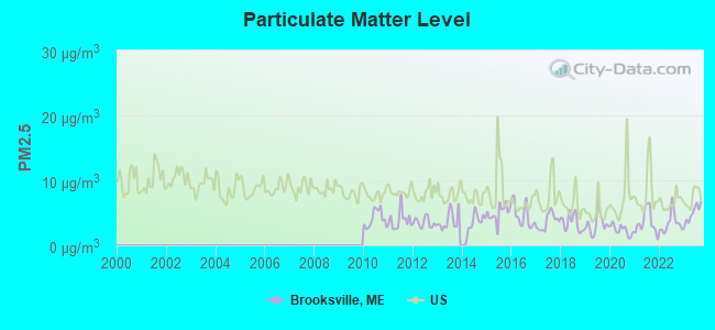
Particulate Matter (PM2.5) [µg/m3] level in 2023 was 4.90. This is significantly better than average. Closest monitor was 24.2 miles away from the city center.
| City: | 4.90 |
| U.S.: | 8.11 |
Earthquake activity:
Brooksville-area historical earthquake activity is significantly above Maine state average. It is 79% smaller than the overall U.S. average.On 10/16/2012 at 23:12:25, a magnitude 4.7 (4.7 ML, Depth: 10.0 mi, Class: Light, Intensity: IV - V) earthquake occurred 108.1 miles away from the city center
On 4/20/2002 at 10:50:47, a magnitude 5.3 (5.3 ML, Depth: 3.0 mi, Class: Moderate, Intensity: VI - VII) earthquake occurred 244.7 miles away from the city center
On 4/20/2002 at 10:50:47, a magnitude 5.2 (5.2 MB, 4.2 MS, 5.2 MW, 5.0 MW) earthquake occurred 245.7 miles away from Brooksville center
On 1/19/1982 at 00:14:42, a magnitude 4.7 (4.5 MB, 4.7 MD, 4.5 LG) earthquake occurred 153.6 miles away from the city center
On 10/7/1983 at 10:18:46, a magnitude 5.3 (5.1 MB, 5.3 LG, 5.1 ML) earthquake occurred 278.9 miles away from Brooksville center
On 2/26/1999 at 03:38:43, a magnitude 3.8 (3.8 LG, Depth: 2.0 mi, Class: Light, Intensity: II - III) earthquake occurred 39.2 miles away from the city center
Magnitude types: regional Lg-wave magnitude (LG), body-wave magnitude (MB), duration magnitude (MD), local magnitude (ML), surface-wave magnitude (MS), moment magnitude (MW)
Natural disasters:
The number of natural disasters in Hancock County (18) is near the US average (15).Major Disasters (Presidential) Declared: 11
Emergencies Declared: 6
Causes of natural disasters: Floods: 9, Storms: 8, Snows: 5, Blizzard: 1, Heavy Rain: 1, Hurricane: 1, Ice Storm: 1, Landslide: 1, Snowfall: 1, Wind: 1, Winter Storm: 1, Other: 2 (Note: some incidents may be assigned to more than one category).
Hospitals and medical centers near Brooksville:
- WALDO COUNTY GENERAL HOSPITAL Critical Access Hospitals (about 13 miles away; BELFAST, ME)
- DIALYSIS CLINIC INC. - BELFAST (Dialysis Facility, about 13 miles away; BELFAST, ME)
- THE COMMONS AT TALL PINES (Nursing Home, about 14 miles away; BELFAST, ME)
- BRADBURY MANOR (Nursing Home, about 14 miles away; BELFAST, ME)
- HARBOR HILL CENTER (Nursing Home, about 15 miles away; BELFAST, ME)
Colleges/universities with over 2000 students nearest to Brooksville:
- Husson University (about 34 miles; Bangor, ME; Full-time enrollment: 2,421)
- University of Maine (about 39 miles; Orono, ME; FT enrollment: 8,931)
- University of Maine at Augusta (about 52 miles; Augusta, ME; FT enrollment: 3,204)
- University of Maine at Farmington (about 73 miles; Farmington, ME; FT enrollment: 2,036)
- Southern Maine Community College (about 89 miles; South Portland, ME; FT enrollment: 4,666)
- University of Southern Maine (about 90 miles; Portland, ME; FT enrollment: 6,647)
- Saint Joseph's College of Maine (about 94 miles; Standish, ME; FT enrollment: 2,010)
Public elementary/middle school in Brooksville:
- BROOKSVILLE ELEMENTARY SCHOOL (Students: 72, Location: 1527 COASTAL ROAD, Grades: PK-8)
Points of interest:
Notable locations in Brooksville: Brooksville Volunteer Fire Department Station 2 (A), Brooksville Volunteer Fire Department Main Station (B). Display/hide their locations on the map
Cemeteries: West Brooksville Cemetery (1), Evergreen Cemetery (2), Lakeview Cemetery (3), Mount Rest Cemetery (4), Wood Cemetery (5), Condon Cemetery (6), Indian Bar Cemetery (7). Display/hide their locations on the map
Lakes, reservoirs, and swamps: Fresh Pond (A), Lily Pond (B), Mill Pond (C), Parker Pond (D), Round Pond (E), Snake Pond (F), Walker Pond (G), Goose Pond (H). Display/hide their locations on the map
Streams, rivers, and creeks: Shepardson Brook (A), Jerrys Brook (B), Marsh Creek (C), Black Brook (D), Meadow Brook (E), Billings Brook (F), Benson Brook (G). Display/hide their locations on the map
Park in Brooksville: Holbrook Island Sanctuary (1). Display/hide its location on the map
Beach: Bakeman Beach (A). Display/hide its location on the map
Tourist attraction: Brooksville Town Of (Cultural Attractions- Events- & Facilities; Library) (1). Display/hide its approximate location on the map
Birthplace of: Michael Connelly (Medal of Honor) - Navy Medal of Honor recipient, Clarence M. Condon - Army Medal of Honor recipient, David Atwood Wasson - Writer.
Drinking water stations with addresses in Brooksville and their reported violations in the past:
BUCKS (Population served: 216, Groundwater):Past health violations:HIRAM BLAKE CAMP (Population served: 50, Groundwater):Past monitoring violations:
- MCL, Acute (TCR) - In AUG-2006, Contaminant: Coliform. Follow-up actions: St Tech Assistance Visit (AUG-25-2006), St Violation/Reminder Notice (AUG-25-2006), St Public Notif requested (AUG-25-2006), St Compliance Meeting conducted (AUG-25-2006), St Boil Water Order (AUG-25-2006), St Compliance achieved (MAY-24-2007), St Intentional no-action (SEP-15-2011)
- 6 routine major monitoring violations
- 6 regular monitoring violations
Past monitoring violations:
- One routine major monitoring violation
| This town: | 2.1 people |
| Maine: | 2.3 people |
| This town: | 66.8% |
| Whole state: | 62.9% |
| This town: | 7.6% |
| Whole state: | 9.4% |
Likely homosexual households (counted as self-reported same-sex unmarried-partner households)
- Lesbian couples: 1.1% of all households
- Gay men: 0.0% of all households
| This town: | 9.7% |
| Whole state: | 10.9% |
| This town: | 3.1% |
| Whole state: | 4.1% |
For population 15 years and over in Brooksville:

- Never married: 17.4%
- Now married: 66.6%
- Separated: 0.0%
- Widowed: 5.9%
- Divorced: 10.1%
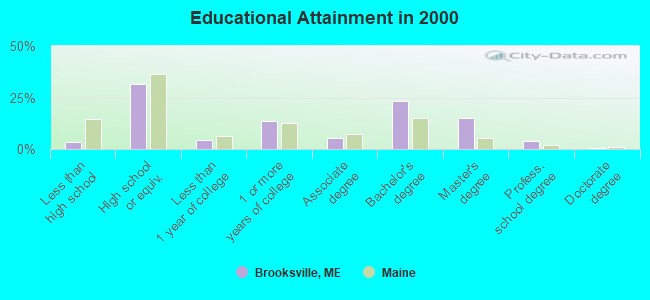
For population 25 years and over in Brooksville:
- High school or higher: 96.7%
- Bachelor's degree or higher: 41.9%
- Graduate or professional degree: 18.8%
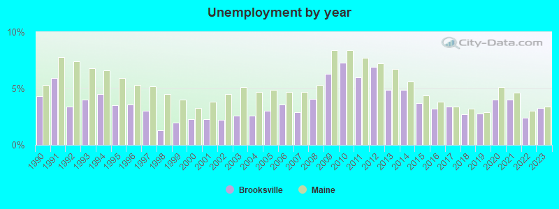
- Unemployed: 4.5%
- Mean travel time to work (commute): 28.2 minutes
| Here: | 9.7 |
| Maine average: | 11.2 |


Graphs represent county-level data. Detailed 2008 Election Results
Religion statistics for Brooksville, ME (based on Hancock County data)


| Religion | Adherents | Congregations |
|---|---|---|
| Mainline Protestant | 4,691 | 58 |
| Catholic | 2,523 | 9 |
| Evangelical Protestant | 1,288 | 23 |
| Other | 820 | 11 |
| None | 45,096 | - |
Food Environment Statistics:
| Hancock County: | 6.01 / 10,000 pop. |
| Maine: | 2.80 / 10,000 pop. |
| Hancock County: | 1.69 / 10,000 pop. |
| State: | 2.20 / 10,000 pop. |
| Hancock County: | 4.89 / 10,000 pop. |
| Maine: | 5.75 / 10,000 pop. |
| Hancock County: | 21.61 / 10,000 pop. |
| State: | 11.02 / 10,000 pop. |
| Hancock County: | 7.4% |
| Maine: | 8.2% |
| Hancock County: | 25.4% |
| Maine: | 25.0% |
Strongest AM radio stations in Brooksville:
- WDEA (1370 AM; 5 kW; ELLSWORTH, ME; Owner: CUMULUS LICENSING CORP.)
- WZON (620 AM; 5 kW; BANGOR, ME; Owner: THE ZONE CORPORATION)
- WABI (910 AM; 5 kW; BANGOR, ME; Owner: CLEAR CHANNEL BROADCASTING LICENSES, INC.)
- WSKW (1160 AM; 10 kW; SKOWHEGAN, ME; Owner: MOUNTAIN WIRELESS, INCORPORATED)
- WRKO (680 AM; 50 kW; BOSTON, MA; Owner: ENTERCOM BOSTON LICENSE, LLC)
- WTME (780 AM; 10 kW; RUMFORD, ME; Owner: MOUNTAIN VALLEY BROADCASTING, INC.)
- WEEI (850 AM; 50 kW; BOSTON, MA; Owner: ENTERCOM BOSTON LICENSE, LLC)
- WBZ (1030 AM; 50 kW; BOSTON, MA; Owner: INFINITY BROADCASTING OPERATIONS, INC.)
- WFAU (1280 AM; 5 kW; GARDINER, ME; Owner: CAPSTAR TX LIMITED PARTNERSHIP)
- WCRN (830 AM; 50 kW; WORCESTER, MA; Owner: CARTER BROADCASTING CORPORATION)
- WNNZ (640 AM; 50 kW; WESTFIELD, MA; Owner: CLEAR CHANNEL BROADCASTING LICENSES, INC.)
- WRKD (1450 AM; 1 kW; ROCKLAND, ME; Owner: CLEAR CHANNEL BROADCASTING LICENSES, INC.)
- WMTW (870 AM; 10 kW; GORHAM, ME; Owner: RADIO PARTNERS OF MAINE, L.P.)
Strongest FM radio stations in Brooksville:
- WFZX (101.7 FM; SEARSPORT, ME; Owner: CLEAR CHANNEL BROADCASTING LICENSES, INC.)
- WERU-FM (89.9 FM; BLUE HILL, ME; Owner: SALT POND COMMUNITY B/C COMPANY)
- WBFB (104.7 FM; BELFAST, ME; Owner: CLEAR CHANNEL BROADCASTING LICENSES, INC.)
- WMEP (90.5 FM; CAMDEN, ME; Owner: MAINE PUBLIC BROADCASTING CORP.)
- WQSS (102.5 FM; CAMDEN, ME; Owner: CLEAR CHANNEL BROADCASTING LICENSES, INC.)
- WWMJ (95.7 FM; ELLSWORTH, ME; Owner: CUMULUS LICENSING CORP.)
- WKIT-FM (100.3 FM; BREWER, ME; Owner: THE ZONE CORPORATION)
- WWBX (97.1 FM; BANGOR, ME; Owner: CLEAR CHANNEL BROADCASTING LICENSES, INC.)
- WBYA (105.5 FM; ISLESBORO, ME; Owner: MARINER BROADCASTING LIMTED PARTNERSHIP)
- WMCM (103.3 FM; ROCKLAND, ME; Owner: CLEAR CHANNEL BROADCASTING LICENSES, INC.)
- WMEH (90.9 FM; BANGOR, ME; Owner: MAINE PUBLIC BROADCASTING CORPORATION)
- WEZQ (92.9 FM; BANGOR, ME; Owner: CUMULUS LICENSING CORP.)
- WNSX (97.7 FM; WINTER HARBOR, ME; Owner: CLEAR CHANNEL BROADCASTING LICENSES, INC.)
- WBQX (106.9 FM; THOMASTON, ME; Owner: MARINER BROADCASTING LIMITED PARTNER)
- WLKE (99.1 FM; BAR HARBOR, ME; Owner: CLEAR CHANNEL BROADCASTING LICENSES, INC.)
TV broadcast stations around Brooksville:
- WABI-TV (Channel 5; BANGOR, ME; Owner: COMMUNITY BROADCASTING SERVICE)
- WCKD-LP (Channel 30; BANGOR/DEDHAM, ME; Owner: J. MCLEOD, ME FAMILY B/CING., INC.)
Brooksville fatal accident list:
Jul 10, 2009 05:36 PM, Varnumville Road, Lat: 44.382519, Lon: -68.730556, Vehicles: 1, Persons: 1, Fatalities: 1
Sep 7, 2006 06:50 PM, Coastal Road, Lat: 44.394740, Lon: -68.757510, Vehicles: 1, Persons: 2, Fatalities: 1
Sep 17, 1995 01:10 PM, 176, Vehicles: 1, Persons: 1, Fatalities: 1
Aug 6, 1994 12:18 AM, 176, Vehicles: 2, Persons: 5, Fatalities: 1
- National Bridge Inventory (NBI) Statistics
- 2Number of bridges
- 16ft / 4.9mTotal length
- 1,318Total average daily traffic
- 65Total average daily truck traffic
- 1,981Total future (year 2036) average daily traffic
FCC Registered Antenna Towers:
5- Erik Brooks, Ferry Road (Lat: 44.406667 Lon: -68.751833), Type: 78.0, Overall height: 76.2 m, Registrant: Holland & Knight LLP, Pconnolly@hkklaw.Com, , Washi-ngton, Phone: (202) 862-5989
- Erik Brooks, Ferry Road (Lat: 44.406667 Lon: -68.751833), Type: 78.0, Overall height: 76.2 m, Registrant: Holland & Knight LLP, Pconnolly@hkklaw.Com, , Washi-ngton, Phone: (202) 862-5989
- Cayla Gamble, Ferry Road (Lat: 44.406667 Lon: -68.751833), Type: 78.0, Structure height: 23009 m, Overall height: 76.2 m, Registrant: Holland & Knight LLP, Peter.Connolly@hklaw.Com, , Washi-ngton, Phone: (202) 862-5989
- Cayla Gamble, Ferry Road (Lat: 44.406667 Lon: -68.751833), Type: 78.0, Structure height: 23009 m, Overall height: 76.2 m, Registrant: Holland & Knight LLP, Peter.Connolly@hklaw.Com, , Washi-ngton, Phone: (202) 862-5989
- Cayla Gamble, Ferry Road (Lat: 44.406667 Lon: -68.751833), Type: 78.0, Structure height: 23009 m, Overall height: 76.2 m, Registrant: Wilkinson Barker Knauer, LLP, Gwerner@wbklaw.Com, , Washi-ngton, Phone: (202) 383-3420
FCC Registered Microwave Towers:
1- 4BG0467A, Town House Road (Lat: 44.364972 Lon: -68.745306), Type: Ltower, Structure height: 59.4 m, Call Sign: WRJP818,
Assigned Frequencies: 11345.0 MHz, 11345.0 MHz, 11345.0 MHz, 11345.0 MHz, 11345.0 MHz, 11345.0 MHz, 11345.0 MHz, 11345.0 MHz, 11345.0 MHz, 11345.0 MHz, Grant Date: 10/06/2020, Expiration Date: 10/06/2030, Cancellation Date: 10/10/2023, Certifier: David Werblow, Registrant: T-Mobile Usa, Inc., 12920 Se 38th Street, Bellevue, WA 98006, Phone: (425) 383-8401, Fax: (425) 383-4040, Email:
FCC Registered Maritime Coast & Aviation Ground Towers:
2- Norvega Point Narumbega Rd (Lat: 44.337583 Lon: -68.741139), Type: Building, Overall height: 7 m, Call Sign: WHX321,
Assigned Frequencies: 156.450 MHz, 156.800 MHz, 156.900 MHz, Grant Date: 05/24/1994, Expiration Date: 05/24/1999, Cancellation Date: 05/06/2001, Registrant: David J Dow, Rfd 5 Box 346 F, Ellsworth, ME 04605
- 684 Coastal Rd (Lat: 44.341750 Lon: -68.736139), Type: Building, Overall height: 5 m, Call Sign: WHX898, Licensee ID: L00079978,
Assigned Frequencies: 156.450 MHz, 156.800 MHz, 156.425 MHz, 156.500 MHz, Grant Date: 04/15/2005, Expiration Date: 07/06/2015, Cancellation Date: 09/19/2015, Registrant: Bucks Harbor Marine Inc, Little Deer Isle, ME 04650, Phone: (207) 348-5253, Fax: (207) 348-5254, Email:
FCC Registered Amateur Radio Licenses:
11 (See the full list of FCC Registered Amateur Radio Licenses in Brooksville)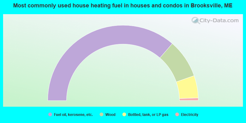
- 72.8%Fuel oil, kerosene, etc.
- 16.6%Wood
- 9.6%Bottled, tank, or LP gas
- 1.1%Electricity
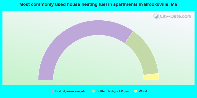
- 69.6%Fuel oil, kerosene, etc.
- 26.8%Bottled, tank, or LP gas
- 3.6%Wood
Brooksville compared to Maine state average:
- Unemployed percentage below state average.
- Black race population percentage significantly below state average.
- Hispanic race population percentage below state average.
- Median age significantly above state average.
- Foreign-born population percentage below state average.
- Renting percentage below state average.
- Length of stay since moving in significantly above state average.
- Number of rooms per house significantly below state average.
- House age significantly below state average.
- Number of college students below state average.
- Percentage of population with a bachelor's degree or higher above state average.

|
Total of 2 patent applications in 2008-2024.