Branchville, Alabama
Submit your own pictures of this town and show them to the world
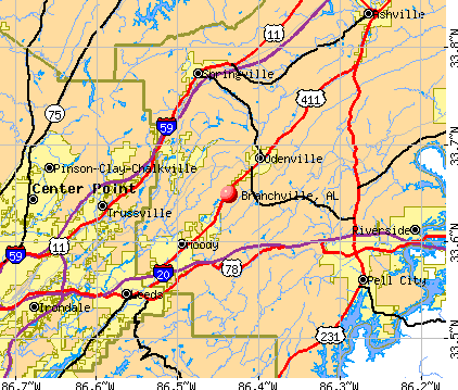
- OSM Map
- General Map
- Google Map
- MSN Map
| Males: 477 | |
| Females: 518 |
| Median resident age: | 40.0 years |
| Alabama median age: | 35.8 years |
Zip codes: 35120.
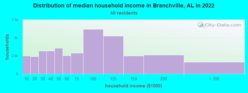
| Branchville: | $76,246 |
| AL: | $59,674 |
Estimated per capita income in 2022: $36,604 (it was $20,541 in 2000)
Branchville town income, earnings, and wages data
Estimated median house or condo value in 2022: $255,389 (it was $91,800 in 2000)
| Branchville: | $255,389 |
| AL: | $200,900 |
Mean prices in 2022: all housing units: $239,342; detached houses: $276,943; townhouses or other attached units: $602,537; in 5-or-more-unit structures: $288,158; mobile homes: $80,275; occupied boats, rvs, vans, etc.: $25,625
Detailed information about poverty and poor residents in Branchville, AL
Compare current foreclosures near Branchville, AL:
| Photo | Address | Area | Beds / Baths | Price | Details |
|---|---|---|---|---|---|

|
#1
Carlisle Dr
Birmingham, AL 35235
|
1,985 sq. feet
|
2 baths 3 beds |
$162,000
|
show details |

|
#2
2nd Ter NW
Birmingham, AL 35215
|
1,323 sq. feet
|
1 baths 3 beds |
$154,900
|
show details |

|
#3
Sun Valley Cir
Sterrett, AL 35147
|
1,188 sq. feet
|
2 baths 2 beds |
$214,500
|
show details |

|
#4
Shadowood Cir
Birmingham, AL 35215
|
1,294 sq. feet
|
2 baths 3 beds |
$2,500
|
show details |

|
#5
Broken Arrow Creek Rd
Riverside, AL 35135
|
1,440 sq. feet
|
1 baths 2 beds |
$199,900
|
show details |

|
#6
Shadowood Cir Apt A
Birmingham, AL 35215
|
1,271 sq. feet
|
2 baths 3 beds |
$2,500
|
show details |

|
#7
Sun Valley Rd
Birmingham, AL 35215
|
4,071 sq. feet
|
2 baths 5 beds |
$117,900
|
show details |

|
#8
1st Pl NW
Birmingham, AL 35215
|
1,524 sq. feet
|
2 baths 3 beds |
$189,900
|
show details |

|
#9
Mccormick Ave
Birmingham, AL 35215
|
880 sq. feet
|
1 baths 3 beds |
$79,000
|
show details |

|
#10
Martinwood Ln
Birmingham, AL 35235
|
1,459 sq. feet
|
2 baths 3 beds |
$84,000
|
show details |
| Photo | Address | Area | Beds / Baths | Price | Details |
|---|---|---|---|---|---|

|
#11
Cheryl Dr
Pinson, AL 35126
|
1,153 sq. feet
|
2 baths 3 beds |
show details | |

|
#12
Summit Park Rd
Odenville, AL 35120
|
- sq. feet
|
2 baths 3 beds |
show details | |

|
#13
Bermuda Dr
Birmingham, AL 35210
|
2,852 sq. feet
|
2 baths 3 beds |
show details | |

|
#14
Woodbrook Rd
Birmingham, AL 35215
|
4,844 sq. feet
|
2 baths 4 beds |
show details | |

|
#15
Summer Crest Dr
Pinson, AL 35126
|
2,145 sq. feet
|
2 baths 3 beds |
show details | |

|
#16
Cedar Creek Rd
Odenville, AL 35120
|
1,888 sq. feet
|
2 baths 3 beds |
show details | |

|
#17
Carmel Rd
Birmingham, AL 35235
|
1,220 sq. feet
|
2 baths 3 beds |
show details | |

|
#18
Heritage Pl
Birmingham, AL 35210
|
- sq. feet
|
3 baths 3 beds |
show details | |

|
#19
Village Mill Rd
Birmingham, AL 35215
|
1,682 sq. feet
|
2 baths 3 beds |
show details | |

|
#20
Redstone Dr
Birmingham, AL 35215
|
1,042 sq. feet
|
2 baths 3 beds |
show details |
| Photo | Address | Area | Beds / Baths | Price | Details |
|---|---|---|---|---|---|

|
#21
Sun Valley Rd
Birmingham, AL 35215
|
1,379 sq. feet
|
2 baths 3 beds |
show details | |

|
#22
Fieldstone Dr
Birmingham, AL 35215
|
1,125 sq. feet
|
2 baths 3 beds |
show details | |

|
#23
Farmhouse Lane
Springville, AL 35146
|
1,428 sq. feet
|
2 baths 4 beds |
show details | |

|
#24
4th Way NW
Birmingham, AL 35215
|
1,038 sq. feet
|
2 baths 3 beds |
show details | |

|
#25
Harness Cir
Pinson, AL 35126
|
1,491 sq. feet
|
5 baths 4 beds |
show details | |

|
#26
Roger Dr
Pinson, AL 35126
|
1,680 sq. feet
|
3 baths 6 beds |
show details | |

|
#27
Sunrise Dr
Moody, AL 35004
|
1,191 sq. feet
|
3 baths 3 beds |
show details | |

|
#28
23rd Ter NW
Birmingham, AL 35215
|
1,232 sq. feet
|
2 baths 3 beds |
show details | |

|
#29
Pin Oak Ln
Odenville, AL 35120
|
1,940 sq. feet
|
2 baths 3 beds |
show details | |

|
#30
Carrington Dr
Trussville, AL 35173
|
2,350 sq. feet
|
3 baths 3 beds |
show details |
| Photo | Address | Area | Beds / Baths | Price | Details |
|---|---|---|---|---|---|

|
#31
Farmhouse Lane
Springville, AL 35146
|
2,273 sq. feet
|
2 baths 4 beds |
show details | |

|
#32
Hickory St
Birmingham, AL 35206
|
1,295 sq. feet
|
3 baths 4 beds |
show details | |

|
#33
Paragon Pkwy
Birmingham, AL 35235
|
2,648 sq. feet
|
3 baths 3 beds |
show details | |

|
#34
5th St NE
Birmingham, AL 35215
|
2,301 sq. feet
|
2 baths 3 beds |
show details | |

|
#35
Mimosa Rd
Leeds, AL 35094
|
- sq. feet
|
2 baths 3 beds |
show details | |

|
#36
Glenwood St NW
Birmingham, AL 35215
|
1,136 sq. feet
|
1 baths 3 beds |
show details | |

|
#37
Old Springville Rd
Birmingham, AL 35215
|
1,593 sq. feet
|
2 baths 3 beds |
show details | |

|
#38
Us Highway 411
Ashville, AL 35953
|
1,392 sq. feet
|
2 baths 4 beds |
show details | |

|
#39
Hines Ln
Pinson, AL 35126
|
1,700 sq. feet
|
2 baths 3 beds |
show details | |

|
#40
Clairmont Dr
Leeds, AL 35094
|
2,050 sq. feet
|
3 baths 4 beds |
show details |
| Photo | Address | Area | Beds / Baths | Price | Details |
|---|---|---|---|---|---|

|
#41
Brewer Ln
Pinson, AL 35126
|
1,982 sq. feet
|
3 baths 3 beds |
show details | |

|
#42
Happy Hollow Rd
Trussville, AL 35173
|
1,745 sq. feet
|
3 baths 3 beds |
show details | |

|
#43
Lakeside Cir
Birmingham, AL 35215
|
1,609 sq. feet
|
2 baths 2 beds |
show details | |

|
#44
Old Springville Rd
Pinson, AL 35126
|
1,335 sq. feet
|
2 baths 3 beds |
show details | |

|
#45
13th Ave NW
Birmingham, AL 35215
|
1,157 sq. feet
|
1 baths 3 beds |
show details | |

|
#46
Isbell Rd
Odenville, AL 35120
|
2,356 sq. feet
|
2 baths 3 beds |
show details | |

|
#47
Wind Song Way
Trussville, AL 35173
|
2,830 sq. feet
|
2 baths 3 beds |
show details | |

|
#48
Burgess Dr
Springville, AL 35146
|
1,370 sq. feet
|
2 baths 3 beds |
show details | |

|
#49
18th Ct NW
Birmingham, AL 35215
|
1,198 sq. feet
|
1 baths 3 beds |
show details | |

|
Check over 1 million property listings on Foreclosure.com!
|
browse all offers | |||

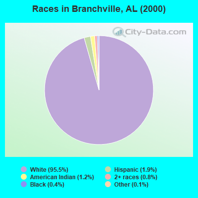
- 78895.5%White alone
- 161.9%Hispanic
- 101.2%American Indian alone
- 70.8%Two or more races
- 30.4%Black alone
- 10.1%Other race alone
 Recent articles from our blog. Our writers, many of them Ph.D. graduates or candidates, create easy-to-read articles on a wide variety of topics.

Latest news from Branchville, AL collected exclusively by city-data.com from local newspapers, TV, and radio stations
Ancestries: United States (30.5%), English (7.5%), Irish (7.2%), German (4.5%), French (3.2%), Italian (1.7%).
Current Local Time: CST time zone
Elevation: 770 feet
Land area: 3.06 square miles.
Population density: 325 people per square mile (very low).
3 residents are foreign born
| This town: | 0.4% |
| Alabama: | 2.0% |
| Branchville town: | 0.3% ($311) |
| Alabama: | 0.4% ($289) |
Nearest city with pop. 50,000+: Birmingham, AL  (23.3 miles , pop. 242,820).
Nearest city with pop. 1,000,000+: Chicago, IL (570.7 miles , pop. 2,896,016).
Nearest cities:
), ), Latitude: 33.65 N, Longitude: 86.44 W
Area code commonly used in this area: 205
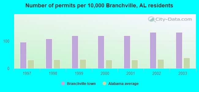
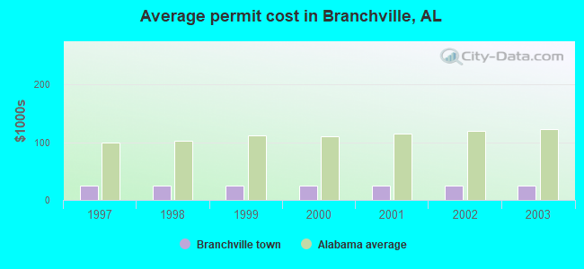
Single-family new house construction building permits:
- 2003: 11 buildings, average cost: $25,000
- 2002: 11 buildings, average cost: $25,000
- 2001: 10 buildings, average cost: $25,000
- 2000: 10 buildings, average cost: $25,000
- 1999: 10 buildings, average cost: $25,000
- 1998: 9 buildings, average cost: $25,000
- 1997: 8 buildings, average cost: $25,000
| Here: | 2.3% |
| Alabama: | 2.6% |
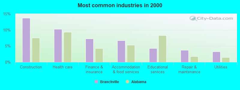
- Construction (13.7%)
- Health care (10.2%)
- Finance & insurance (7.3%)
- Accommodation & food services (6.7%)
- Educational services (4.3%)
- Repair & maintenance (3.8%)
- Utilities (3.2%)
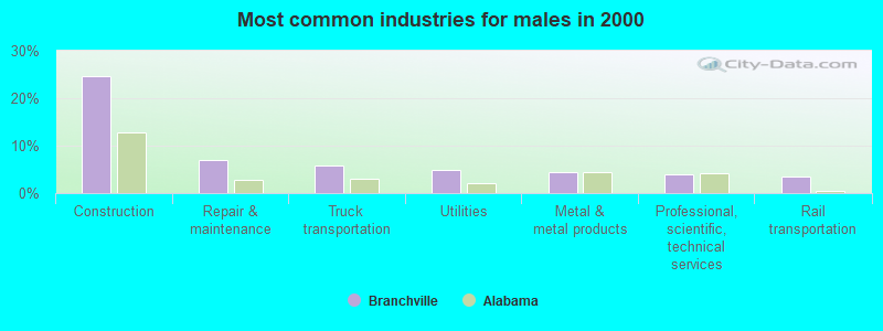
- Construction (24.6%)
- Repair & maintenance (6.9%)
- Truck transportation (5.9%)
- Utilities (4.9%)
- Metal & metal products (4.4%)
- Professional, scientific, technical services (3.9%)
- Rail transportation (3.4%)
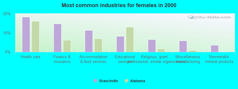
- Health care (18.3%)
- Finance & insurance (14.8%)
- Accommodation & food services (11.2%)
- Educational services (8.3%)
- Religious, grantmaking, civic, professional, similar organizations (6.5%)
- Miscellaneous manufacturing (5.9%)
- Nonmetallic mineral products (3.6%)
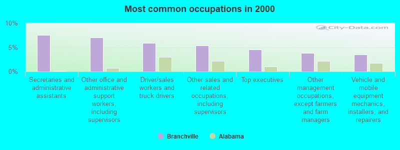
- Secretaries and administrative assistants (7.5%)
- Other office and administrative support workers, including supervisors (7.0%)
- Driver/sales workers and truck drivers (5.9%)
- Other sales and related occupations, including supervisors (5.4%)
- Top executives (4.6%)
- Other management occupations, except farmers and farm managers (3.8%)
- Vehicle and mobile equipment mechanics, installers, and repairers (3.5%)
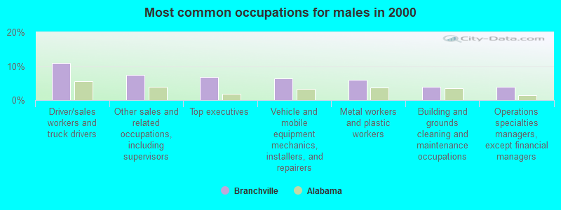
- Driver/sales workers and truck drivers (10.8%)
- Other sales and related occupations, including supervisors (7.4%)
- Top executives (6.9%)
- Vehicle and mobile equipment mechanics, installers, and repairers (6.4%)
- Metal workers and plastic workers (5.9%)
- Building and grounds cleaning and maintenance occupations (3.9%)
- Operations specialties managers, except financial managers (3.9%)
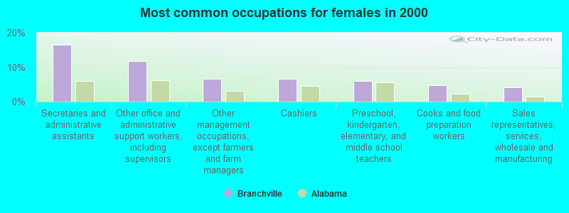
- Secretaries and administrative assistants (16.6%)
- Other office and administrative support workers, including supervisors (11.8%)
- Other management occupations, except farmers and farm managers (6.5%)
- Cashiers (6.5%)
- Preschool, kindergarten, elementary, and middle school teachers (5.9%)
- Cooks and food preparation workers (4.7%)
- Sales representatives, services, wholesale and manufacturing (4.1%)
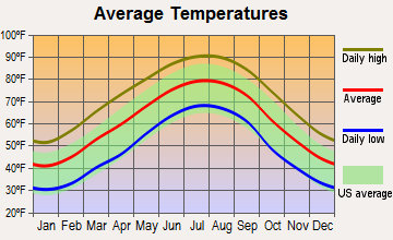
Average climate in Branchville, Alabama
Based on data reported by over 4,000 weather stations


(lower is better)
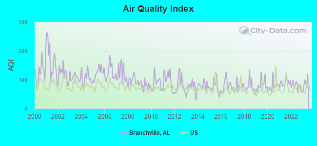
Air Quality Index (AQI) level in 2022 was 78.0. This is about average.
| City: | 78.0 |
| U.S.: | 72.6 |
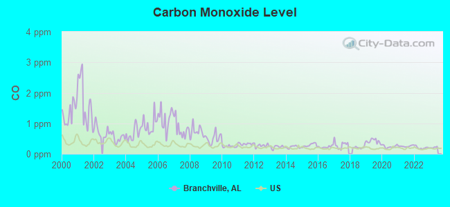
Carbon Monoxide (CO) [ppm] level in 2022 was 0.203. This is better than average. Closest monitor was 9.6 miles away from the city center.
| City: | 0.203 |
| U.S.: | 0.251 |
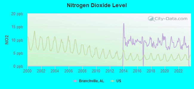
Nitrogen Dioxide (NO2) [ppb] level in 2022 was 8.64. This is significantly worse than average. Closest monitor was 9.4 miles away from the city center.
| City: | 8.64 |
| U.S.: | 5.11 |
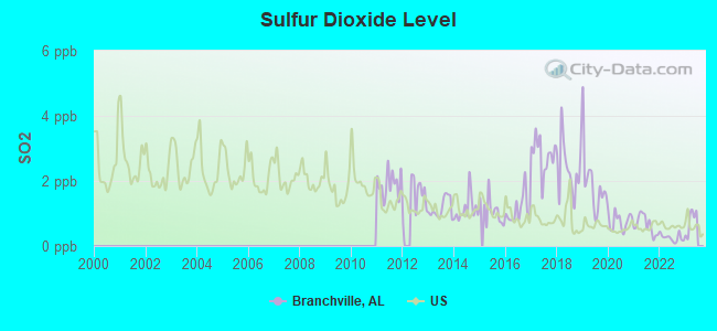
Sulfur Dioxide (SO2) [ppb] level in 2022 was 0.254. This is significantly better than average. Closest monitor was 9.4 miles away from the city center.
| City: | 0.254 |
| U.S.: | 1.515 |
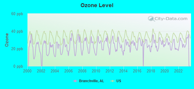
Ozone [ppb] level in 2022 was 25.5. This is better than average. Closest monitor was 9.6 miles away from the city center.
| City: | 25.5 |
| U.S.: | 33.3 |
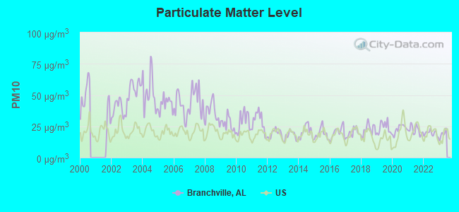
Particulate Matter (PM10) [µg/m3] level in 2022 was 19.3. This is about average. Closest monitor was 9.4 miles away from the city center.
| City: | 19.3 |
| U.S.: | 19.2 |
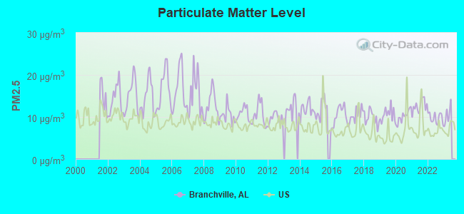
Particulate Matter (PM2.5) [µg/m3] level in 2022 was 9.78. This is worse than average. Closest monitor was 9.6 miles away from the city center.
| City: | 9.78 |
| U.S.: | 8.11 |
Tornado activity:
Branchville-area historical tornado activity is slightly above Alabama state average. It is 154% greater than the overall U.S. average.
On 4/4/1977, a category F5 (max. wind speeds 261-318 mph) tornado 15.5 miles away from the Branchville town center killed 22 people and injured 130 people and caused between $5,000,000 and $50,000,000 in damages.
On 4/8/1998, a category F5 tornado 25.4 miles away from the town center killed 32 people and injured 259 people and caused $200 million in damages.
Earthquake activity:
Branchville-area historical earthquake activity is significantly above Alabama state average. It is 120% greater than the overall U.S. average.On 1/18/1999 at 07:00:53, a magnitude 4.8 (4.8 MB, 4.0 LG, Depth: 0.6 mi, Class: Light, Intensity: IV - V) earthquake occurred 50.1 miles away from Branchville center
On 4/29/2003 at 08:59:39, a magnitude 4.9 (4.4 MB, 4.6 MW, 4.9 LG) earthquake occurred 74.6 miles away from the city center
On 4/29/2003 at 08:59:39, a magnitude 4.6 (4.6 MW, Depth: 12.3 mi) earthquake occurred 74.6 miles away from Branchville center
On 6/24/1975 at 11:11:36, a magnitude 4.5 (4.5 MB) earthquake occurred 80.9 miles away from the city center
On 10/24/1997 at 08:35:17, a magnitude 4.9 (4.8 MB, 4.2 MS, 4.9 LG, Depth: 6.2 mi) earthquake occurred 181.3 miles away from Branchville center
On 8/2/1974 at 08:52:09, a magnitude 4.9 (4.3 MB, 4.9 LG) earthquake occurred 227.6 miles away from the city center
Magnitude types: regional Lg-wave magnitude (LG), body-wave magnitude (MB), surface-wave magnitude (MS), moment magnitude (MW)
Natural disasters:
The number of natural disasters in St. Clair County (3) is a lot smaller than the US average (15).Major Disasters (Presidential) Declared: 1
Causes of natural disasters: Storms: 2, Tornadoes: 2, Flood: 1, Wind: 1, Other: 1 (Note: some incidents may be assigned to more than one category).
Hospitals and medical centers near Branchville:
- DCI PELL CITY (Dialysis Facility, about 9 miles away; PELL CITY, AL)
- GOLDEN LIVING CENTER - TRUSSVILLE (Nursing Home, about 11 miles away; TRUSSVILLE, AL)
- LAKESIDE HOSPICE INC (Hospital, about 13 miles away; PELL CITY, AL)
- BIRMINGHAM NURSING AND REHABILITATION CENTER EAST (Nursing Home, about 14 miles away; BIRMINGHAM, AL)
- KIRKWOOD BY THE RIVER (Nursing Home, about 14 miles away; BIRMINGHAM, AL)
- DAVITA CENTER POINT DIALYSIS (Dialysis Facility, about 15 miles away; CENTER POINT, AL)
- SOUTHERN CARE BIRMINGHAM (Hospital, about 15 miles away; BIRMINGHAM, AL)
Colleges/universities with over 2000 students nearest to Branchville:
- Jefferson State Community College (about 16 miles; Birmingham, AL; Full-time enrollment: 6,041)
- University of Alabama at Birmingham (about 24 miles; Birmingham, AL; FT enrollment: 14,853)
- Samford University (about 25 miles; Birmingham, AL; FT enrollment: 3,829)
- Virginia College-Birmingham (about 26 miles; Birmingham, AL; FT enrollment: 8,167)
- Lawson State Community College-Birmingham Campus (about 30 miles; Birmingham, AL; FT enrollment: 2,695)
- Gadsden State Community College (about 35 miles; Gadsden, AL; FT enrollment: 4,650)
- George C Wallace State Community College-Hanceville (about 36 miles; Hanceville, AL; FT enrollment: 4,486)
Points of interest:
Notable location: Odenville Fire and Rescue Station 3 (A). Display/hide its location on the map
Churches in Branchville include: Ebenezer Baptist Church (A), New Life Church (B). Display/hide their locations on the map
Cemetery: Branchville Cemetery (1). Display/hide its location on the map
| This town: | 2.6 people |
| Alabama: | 2.5 people |
| This town: | 80.3% |
| Whole state: | 70.4% |
| This town: | 1.9% |
| Whole state: | 3.4% |
No gay or lesbian households reported
| This town: | 7.8% |
| Whole state: | 16.1% |
| This town: | 2.6% |
| Whole state: | 7.3% |
For population 15 years and over in Branchville:
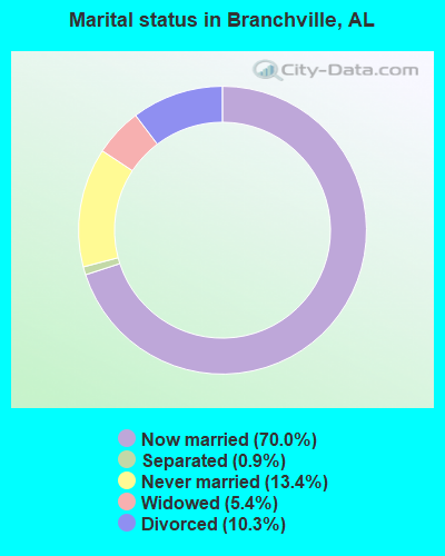
- Never married: 13.4%
- Now married: 70.0%
- Separated: 0.9%
- Widowed: 5.4%
- Divorced: 10.3%
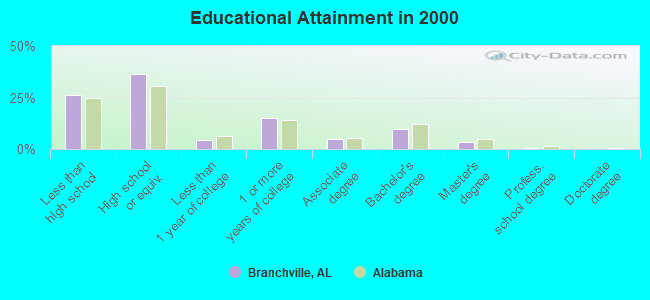
For population 25 years and over in Branchville:
- High school or higher: 74.0%
- Bachelor's degree or higher: 13.3%
- Graduate or professional degree: 3.7%
- Unemployed: 2.6%
- Mean travel time to work (commute): 36.5 minutes
| Here: | 11.1 |
| Alabama average: | 13.2 |
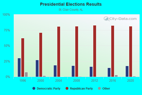
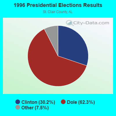
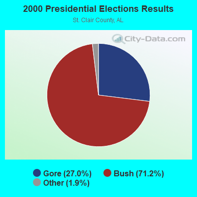
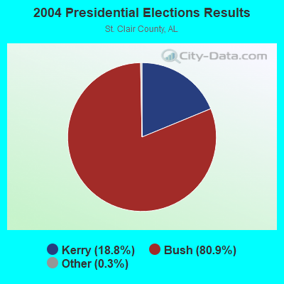
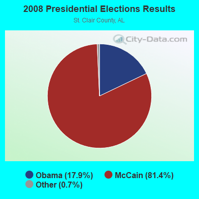
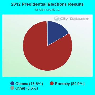

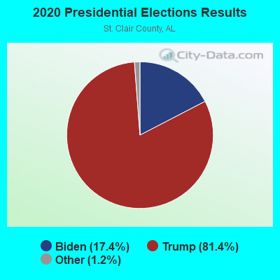
Graphs represent county-level data. Detailed 2008 Election Results
Religion statistics for Branchville, AL (based on St. Clair County data)
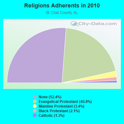
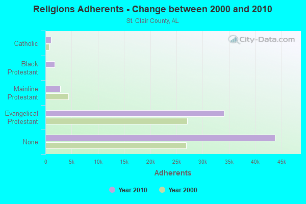
| Religion | Adherents | Congregations |
|---|---|---|
| Evangelical Protestant | 34,066 | 121 |
| Mainline Protestant | 2,856 | 18 |
| Black Protestant | 1,778 | 12 |
| Catholic | 1,056 | 1 |
| Other | 12 | 2 |
| None | 43,825 | - |
Food Environment Statistics:
| St. Clair County: | 1.79 / 10,000 pop. |
| Alabama: | 1.89 / 10,000 pop. |
| Here: | 0.13 / 10,000 pop. |
| State: | 0.20 / 10,000 pop. |
| St. Clair County: | 0.26 / 10,000 pop. |
| Alabama: | 0.65 / 10,000 pop. |
| This county: | 5.64 / 10,000 pop. |
| Alabama: | 6.32 / 10,000 pop. |
| Here: | 5.77 / 10,000 pop. |
| Alabama: | 5.75 / 10,000 pop. |
| St. Clair County: | 10.7% |
| State: | 11.8% |
| St. Clair County: | 33.9% |
| Alabama: | 31.7% |
| St. Clair County: | 9.2% |
| State: | 13.5% |
| Local government employment and payroll (March 2002) | |||||
| Function | Full-time employees | Monthly full-time payroll | Average yearly full-time wage | Part-time employees | Monthly part-time payroll |
|---|---|---|---|---|---|
| Police Protection - Officers | 1 | $1,915 | $22,980 | 2 | $1,446 |
| Other Government Administration | 0 | $0 | 1 | $1,087 | |
| Judicial and Legal | 0 | $0 | 2 | $1,218 | |
| Totals for Government | 1 | $1,915 | $22,980 | 5 | $3,751 |
Strongest AM radio stations in Branchville:
- WDJC (850 AM; 50 kW; BIRMINGHAM, AL; Owner: KIMTRON, INC.)
- WJOX (690 AM; 50 kW; BIRMINGHAM, AL; Owner: CITADEL BROADCASTING COMPANY)
- WFHK (1430 AM; 5 kW; PELL CITY, AL; Owner: STOCKS BROADCASTING, INC.)
- WAPI (1070 AM; 50 kW; BIRMINGHAM, AL; Owner: CITADEL BROADCASTING COMPANY)
- WURL (760 AM; daytime; 1 kW; MOODY, AL; Owner: THE BILL DAVISON EVANGELISTIC ASSOC)
- WNSI (810 AM; 50 kW; JACKSONVILLE, AL; Owner: UNITED BROADCASTING NETWORK, INC.)
- WLPH (1480 AM; daytime; 5 kW; IRONDALE, AL; Owner: BIRMINGHAM CHRISTIAN RADIO, INC.)
- WKNG (1060 AM; daytime; 50 kW; TALLAPOOSA, GA; Owner: WKNG, INC.)
- WYDE (1260 AM; 5 kW; BIRMINGHAM, AL; Owner: KIMTRON, INC.)
- WERC (960 AM; 5 kW; BIRMINGHAM, AL; Owner: CAPSTAR TX LIMITED PARTNERSHIP)
- WAAX (570 AM; 5 kW; GADSDEN, AL; Owner: CAPSTAR TX LIMITED PARTNERSHIP)
- WRJS (1320 AM; 5 kW; BIRMINGHAM, AL; Owner: CXR HOLDINGS, INC.)
- WGST (640 AM; 50 kW; ATLANTA, GA; Owner: CITICASTERS LICENSES, L.P.)
Strongest FM radio stations in Branchville:
- WRAX (107.7 FM; BIRMINGHAM, AL; Owner: CITADEL BROADCASTING COMPANY)
- WBPT (106.9 FM; BIRMINGHAM, AL; Owner: CXR HOLDINGS, INC.)
- WGIB (91.9 FM; BIRMINGHAM, AL; Owner: GLEN IRIS BAPTIST SCHOOL)
- WBHK (98.7 FM; WARRIOR, AL; Owner: CXR HOLDINGS, INC.)
- WZZK-FM (104.7 FM; BIRMINGHAM, AL; Owner: CXR HOLDINGS, INC.)
- WBHM (90.3 FM; BIRMINGHAM, AL; Owner: BD OF TRUSTEES/U OF AL AT BIRMINGHAM)
- WODL (97.3 FM; HOMEWOOD, AL; Owner: CXR HOLDINGS, INC.)
- WENN (105.9 FM; TRUSSVILLE, AL; Owner: CAPSTAR TX LIMITED PARTNERSHIP)
- WYSF (94.5 FM; BIRMINGHAM, AL; Owner: CITADEL BROADCASTING COMPANY)
- WTDR (92.7 FM; TALLADEGA, AL; Owner: JACOBS BROADCAST GROUP, INC.)
- WTBJ (91.3 FM; OXFORD, AL; Owner: TRINITY CHRISTIAN ACADEMY)
- WMJJ (96.5 FM; BIRMINGHAM, AL; Owner: CAPSTAR TX LIMITED PARTNERSHIP)
- WQEN (103.7 FM; GADSDEN, AL; Owner: CAPSTAR TX LIMITED PARTNERSHIP)
- WDJC-FM (93.7 FM; BIRMINGHAM, AL; Owner: KIMTRON, INC.)
- WZRR (99.5 FM; BIRMINGHAM, AL; Owner: CITADEL BROADCASTING COMPANY)
- WYDE-FM (101.1 FM; CULLMAN, AL; Owner: KIMTRON, INC.)
- WVOK-FM (97.9 FM; OXFORD, AL; Owner: WOODARD BROADCASTING CO. INC.)
- WLJR (88.5 FM; BIRMINGHAM, AL; Owner: BRIARWOOD PRESBYTERIAN CHURCH)
- WDXB (102.5 FM; JASPER, AL; Owner: CAPSTAR TX LIMITED PARTNERSHIP)
- WBFR (89.5 FM; BIRMINGHAM, AL; Owner: FAMILY STATIONS, INC.)
TV broadcast stations around Branchville:
- WJSU-TV (Channel 40; ANNISTON, AL; Owner: TV ALABAMA, INC.)
- WTJP (Channel 60; GADSDEN, AL; Owner: TRINITY BROADCASTING NETWORK)
- WIAT (Channel 42; BIRMINGHAM, AL; Owner: MEDIA GENERAL COMMUNICATIONS, INC.)
- WBIQ (Channel 10; BIRMINGHAM, AL; Owner: ALABAMA EDUCATIONAL TELEVISION COMMISSION)
- WBRC (Channel 6; BIRMINGHAM, AL; Owner: WBRC LICENSE, INC.)
- WTTO (Channel 21; HOMEWOOD, AL; Owner: WTTO LICENSEE, LLC)
- WVTM-TV (Channel 13; BIRMINGHAM, AL; Owner: BIRMINGHAM BROADCASTING (WVTM-TV), LLC)
- WPXH (Channel 44; GADSDEN, AL; Owner: PAXSON COMMUNICATIONS LICENSE COMPANY, LLC)
- WABM (Channel 68; BIRMINGHAM, AL; Owner: BIRMINGHAM (WABM-TV) LICENSEE, INC.)
- WBXA-CA (Channel 2; BIRMINGHAM, AL; Owner: THE BOX WORLDWIDE LLC)
- WDBB (Channel 17; BESSEMER, AL; Owner: WDBB-TV, INC.)
- WCFT-TV (Channel 33; TUSCALOOSA, AL; Owner: TV ALABAMA, INCORPORATED)
- W27CM (Channel 27; BIRMINGHAM, AL; Owner: EQUITY BROADCASTING CORPORATION)
- WBMG-LP (Channel 38; MOODY, AL; Owner: TIGER EYE BROADCASTING CORPORATION)
- W46DK (Channel 46; BIRMINGHAM, AL; Owner: TRINITY BROADCASTING NETWORK)
- WBMA-LP (Channel 58; BIRMINGHAM, AL; Owner: TV ALABAMA, INC.)
Branchville fatal accident list:
- National Bridge Inventory (NBI) Statistics
- 1Number of bridges
- 7ft / 2.4mTotal length
- $1,370,000Total costs
- 136Total average daily traffic
- 4Total average daily truck traffic
- 992Total future (year 2040) average daily traffic
FCC Registered Antenna Towers:
7- Michelle Wofford, Greene Dunn - 11578 Us Hwy 411 (Lat: 32.981389 Lon: -88.033194), Type: 79.2, Overall height: 76.2 m, Registrant: Southeast Towers, LLC, Mwofford@setowers.Com, , Atlan-ta, Phone: (770) 350-0608
- Amanda K Bernard, Greene Dunn - 11578 Us Hwy 411 (Lat: 32.981389 Lon: -88.033194), Type: 79.2, Overall height: 76.2 m, Registrant: Southeast Towers, LLC, Mwofford@setowers.Com, , Atlan-ta, Phone: (770) 350-0608
- Amanda K Bernard, Greene Dunn - 11578 Us Hwy 411 (Lat: 32.981389 Lon: -88.033194), Type: 76.2, Overall height: 74.6 m, Registrant: Southeast Towers, LLC, Abernard@setowers.Com, , Atlan-ta, Phone: (770) 350-0608
- Amanda K Bernard, Greene Dunn - 11578 Us Hwy 411 (Lat: 32.981389 Lon: -88.033194), Type: 76.2, Overall height: 74.6 m, Registrant: Southeast Towers, LLC, Abernard@setowers.Com, , Atlan-ta, Phone: (770) 350-0608
- Sarah L Berry, Greene Dunn - 11578 Us Hwy 411 (Lat: 32.981389 Lon: -88.033194), Type: 76.2, Overall height: 74.6 m, Registrant: Diamond Towers LLC, Sberry@diamondcomm.Com, , Brook-field, Phone: (262) 649-4429
- Sarah L Berry, Greene Dunn - 11578 Us Hwy 411 (Lat: 32.981389 Lon: -88.033194), Type: 76.2, Overall height: 74.6 m, Registrant: Diamond Communications LLC, Sberry@diamondcomm.Com, , Brook-field, Phone: (262) 649-4429
- Bridget Carter, Greene Dunn - 11578 Us Hwy 411 (Lat: 32.981389 Lon: -88.033194), Type: 76.2, Structure height: 01063 m, Overall height: 74.6 m, Registrant: American Towers, LLC, Faa-Fcc@americantower.Com, , Wobur-n, Phone: (678) 265-6770
FCC Registered Private Land Mobile Towers:
1- 3560 Bald Rock Mountain Rd (Lat: 33.605667 Lon: -86.419139), Type: Tower, Structure height: 15 m, Call Sign: WPFR882,
Assigned Frequencies: 858.812 MHz, 858.837 MHz, 858.887 MHz, 858.912 MHz, 859.287 MHz, 859.337 MHz, 859.362 MHz, 859.387 MHz, 859.787 MHz, 859.812 MHz... (+10 more), Grant Date: 07/30/2019, Expiration Date: 06/08/2029, Registrant: Southern Communications Services, Inc D/B/A Southern Linc, 600 18th St N Bin Sn-0800, Birmingham, AL 35203-2206, Phone: (205) 257-1534, Email:
FCC Registered Broadcast Land Mobile Towers:
3- Blair Farm Rd (Lat: 33.659000 Lon: -86.429139), Call Sign: KNGN575,
Assigned Frequencies: 154.205 MHz, Grant Date: 03/25/1998, Expiration Date: 05/27/2003, Cancellation Date: 09/07/2003, Registrant: Branchville, Town Of, Odenville, AL 35120, Phone: (205) 629-5165
- Bald Rock Mountain 4 Mi S (Lat: 33.605667 Lon: -86.419139), Call Sign: KNFA762, Licensee ID: L00000301,
Assigned Frequencies: 451.075 MHz, 451.075 MHz, Grant Date: 03/12/2002, Expiration Date: 03/19/2012, Cancellation Date: 03/29/2002, Registrant: Alabama Power Company, C/O Scs, 600 North 18th Street / Bin 5n-8485, Birmingham, AL 35203-8485, Phone: (205) 257-3227, Fax: (205) 257-3636, Email:
- REPEATER, 0.5mi Nw 241 Rocky Rd (Lat: 33.605250 Lon: -86.417444), Type: Pipe, Structure height: 6.1 m, Call Sign: WPTD590,
Assigned Frequencies: 451.112 MHz, Grant Date: 08/09/2011, Expiration Date: 09/05/2021, Cancellation Date: 11/06/2021, Certifier: Christopher B Leonard, Registrant: Duke Instrument Service Co., 9520 Old Hwy 43, Creola, AL 36525, Phone: (251) 675-6067, Fax: (251) 675-5938, Email:
FCC Registered Microwave Towers:
8 (See the full list of FCC Registered Microwave Towers in this town)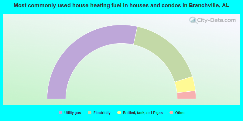
- 56.8%Utility gas
- 33.3%Electricity
- 6.3%Bottled, tank, or LP gas
- 2.8%Wood
- 0.7%No fuel used
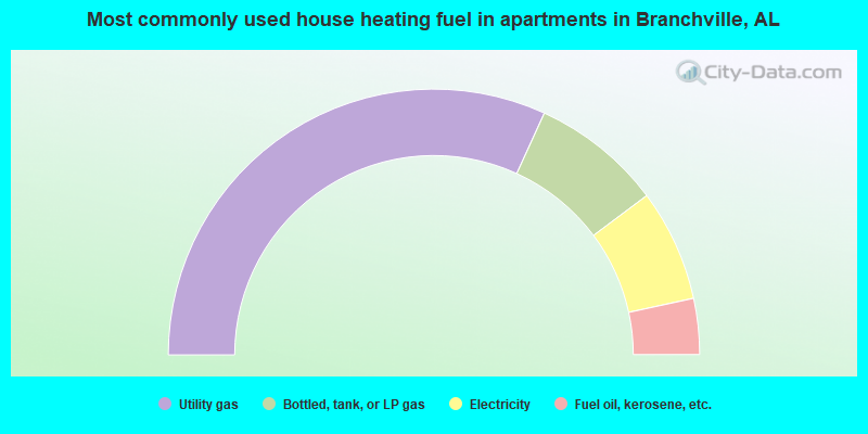
- 63.6%Utility gas
- 15.9%Bottled, tank, or LP gas
- 13.6%Electricity
- 6.8%Fuel oil, kerosene, etc.
Branchville compared to Alabama state average:
- Unemployed percentage significantly below state average.
- Black race population percentage significantly below state average.
- Hispanic race population percentage below state average.
- Foreign-born population percentage significantly below state average.
- Renting percentage significantly below state average.
- Length of stay since moving in significantly above state average.
- Number of rooms per house significantly below state average.
- House age significantly below state average.
- Number of college students below state average.