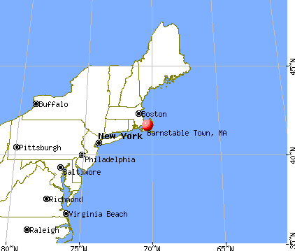
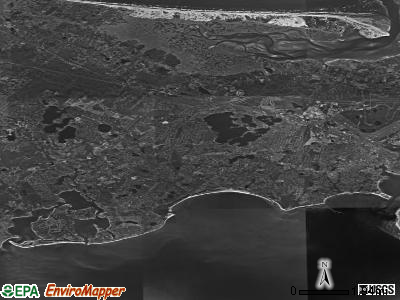
Barnstable Town, Massachusetts
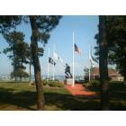
Barnstable Town: War Memorial, Barnstable Massachusetts
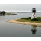
Barnstable Town: Leaving Port for Nantucket
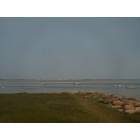
Barnstable Town: Barnstable Harbor and Sandy Neck
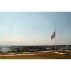
Barnstable Town: Hyannisport Golf Club, Barnstable Massachusetts
- add
your
Submit your own pictures of this city and show them to the world
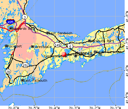
- OSM Map
- General Map
- Google Map
- MSN Map
| Males: 22,761 | |
| Females: 24,846 |
| Median resident age: | 42.3 years |
| Massachusetts median age: | 36.5 years |
Zip codes: 02632.
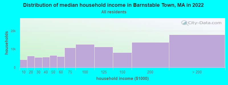
| Barnstable Town: | $93,186 |
| MA: | $94,488 |
Estimated per capita income in 2022: $60,930 (it was $25,554 in 2000)
Barnstable Town city income, earnings, and wages data
Estimated median house or condo value in 2022: $604,767 (it was $170,600 in 2000)
| Barnstable Town: | $604,767 |
| MA: | $534,700 |
Mean prices in 2022: all housing units: $623,757; detached houses: $648,447; townhouses or other attached units: $490,502; in 2-unit structures: $577,155; in 3-to-4-unit structures: $445,551; in 5-or-more-unit structures: $351,307; mobile homes: $108,058
Barnstable Town, MA residents, houses, and apartments details
Detailed information about poverty and poor residents in Barnstable Town, MA
Compare current foreclosures near Barnstable Town, MA:
| Photo | Address | Area | Beds / Baths | Price | Details |
|---|---|---|---|---|---|

|
#1
W Falmouth Hwy
Falmouth, MA 02540
|
1,224 sq. feet
|
2 baths 4 beds |
$665,000
|
show details |

|
#2
Quaker Run Rd
Mashpee, MA 02649
|
3,010 sq. feet
|
3 baths 4 beds |
show details | |

|
#3
Thistle Dr
Centerville, MA 02632
|
2,207 sq. feet
|
3 baths 3 beds |
show details | |

|
#4
Manamok Cir
Sandwich, MA 02563
|
1,232 sq. feet
|
2 baths 3 beds |
show details | |

|
#5
Remington Ln
Plymouth, MA 02360
|
1,758 sq. feet
|
3 baths 3 beds |
show details | |

|
#6
Main St
Brewster, MA 02631
|
1,881 sq. feet
|
2 baths 5 beds |
show details | |

|
#7
Holly Cir # 16a
Buzzards Bay, MA 02532
|
1,451 sq. feet
|
1 baths 3 beds |
show details | |

|
#8
Queen Anne Rd
Harwich, MA 02645
|
1,512 sq. feet
|
2 baths 4 beds |
show details | |

|
#9
Pleasant St
South Chatham, MA 02659
|
3,180 sq. feet
|
3 baths 4 beds |
show details | |

|
#10
Dillingham Ave
Sandwich, MA 02563
|
1,008 sq. feet
|
1 baths 2 beds |
show details |
| Photo | Address | Area | Beds / Baths | Price | Details |
|---|---|---|---|---|---|

|
#11
Cappawack Rd
Mashpee, MA 02649
|
1,428 sq. feet
|
1 baths 3 beds |
show details | |

|
#12
N Main St
South Yarmouth, MA 02664
|
1,404 sq. feet
|
2 baths 4 beds |
show details | |

|
#13
Fordham Cir
East Falmouth, MA 02536
|
1,784 sq. feet
|
1 baths 3 beds |
show details | |

|
#14
Tupper Rd
Sandwich, MA 02563
|
2,872 sq. feet
|
4 baths 5 beds |
show details | |

|
#15
Tupper Ave
Sandwich, MA 02563
|
1,344 sq. feet
|
2 baths 3 beds |
show details | |

|
#16
Sailfish Dr
East Falmouth, MA 02536
|
1,539 sq. feet
|
2 baths 4 beds |
show details | |

|
#17
Edgewater Dr
East Falmouth, MA 02536
|
884 sq. feet
|
1 baths 3 beds |
show details | |

|
#18
Nickerson Farm Way
South Yarmouth, MA 02664
|
1,512 sq. feet
|
1 baths 3 beds |
show details | |

|
#19
Wheelhouse Cir
East Falmouth, MA 02536
|
2,012 sq. feet
|
1 baths 3 beds |
show details | |

|
#20
Davisville Rd
East Falmouth, MA 02536
|
962 sq. feet
|
1 baths 3 beds |
show details |
| Photo | Address | Area | Beds / Baths | Price | Details |
|---|---|---|---|---|---|

|
#21
Juniper Ln
Harwich, MA 02645
|
1,437 sq. feet
|
2 baths 2 beds |
show details | |

|
#22
Meadow Lark Ln
Sagamore Beach, MA 02562
|
1,260 sq. feet
|
1 baths 3 beds |
show details | |

|
#23
Crofton Ln
East Falmouth, MA 02536
|
1,642 sq. feet
|
2 baths 4 beds |
show details | |

|
#24
Winsome Rd
South Yarmouth, MA 02664
|
1,296 sq. feet
|
2 baths 4 beds |
show details | |

|
#25
Powhatan Rd
South Yarmouth, MA 02664
|
944 sq. feet
|
1 baths 2 beds |
show details | |

|
#26
Tanglewood Dr
East Falmouth, MA 02536
|
1,004 sq. feet
|
1 baths 3 beds |
show details | |

|
#27
Tall Pines Dr
Yarmouth Port, MA 02675
|
1,560 sq. feet
|
1 baths 3 beds |
show details | |

|
#28
Main St
Mashpee, MA 02649
|
2,086 sq. feet
|
2 baths 3 beds |
show details | |

|
#29
Evergreen St
South Yarmouth, MA 02664
|
908 sq. feet
|
2 baths 3 beds |
show details | |

|
#30
Cobb Ave
Yarmouth Port, MA 02675
|
1,144 sq. feet
|
1 baths 3 beds |
show details |
| Photo | Address | Area | Beds / Baths | Price | Details |
|---|---|---|---|---|---|

|
#31
Aurora Ln
South Yarmouth, MA 02664
|
1,144 sq. feet
|
2 baths 3 beds |
show details | |

|
#32
Captain Blount Rd
South Yarmouth, MA 02664
|
1,317 sq. feet
|
2 baths 3 beds |
show details | |

|
#33
Captain Weiler Rd
South Yarmouth, MA 02664
|
1,144 sq. feet
|
1 baths 3 beds |
show details | |

|
#34
Canvasback Ln
West Yarmouth, MA 02673
|
1,462 sq. feet
|
2 baths 3 beds |
show details | |

|
#35
Ashumet Rd Unit 17b
Mashpee, MA 02649
|
864 sq. feet
|
1 baths 2 beds |
show details | |

|
#36
Forest Rd
West Yarmouth, MA 02673
|
1,200 sq. feet
|
1 baths 3 beds |
show details | |

|
#37
Jonathans Way
Brewster, MA 02631
|
1,020 sq. feet
|
1 baths 2 beds |
show details | |

|
#38
Trowbridge Path
West Yarmouth, MA 02673
|
1,200 sq. feet
|
2 baths 3 beds |
show details | |

|
#39
Brush Hill Rd
Yarmouth Port, MA 02675
|
1,575 sq. feet
|
2 baths 3 beds |
show details | |

|
#40
Circuit Rd N
West Yarmouth, MA 02673
|
832 sq. feet
|
1 baths 2 beds |
show details |
| Photo | Address | Area | Beds / Baths | Price | Details |
|---|---|---|---|---|---|

|
#41
Main St
Harwich, MA 02645
|
1,248 sq. feet
|
2 baths 3 beds |
show details | |

|
#42
Braxton Rd
East Falmouth, MA 02536
|
1,184 sq. feet
|
1 baths 3 beds |
show details | |

|
#43
Hedges Pond Rd
Plymouth, MA 02360
|
1,040 sq. feet
|
1 baths 3 beds |
show details | |

|
#44
Saltworks Ln
Buzzards Bay, MA 02532
|
954 sq. feet
|
2 baths 3 beds |
show details | |

|
#45
Whitley Trl
Plymouth, MA 02360
|
1,288 sq. feet
|
2 baths 2 beds |
show details | |

|
#46
Cohasset Rd
Buzzards Bay, MA 02532
|
624 sq. feet
|
1 baths 2 beds |
show details | |

|
#47
Bournehurst Dr
Plymouth, MA 02360
|
1,536 sq. feet
|
1 baths 3 beds |
show details | |

|
#48
Walnut St
Plymouth, MA 02360
|
704 sq. feet
|
1 baths 2 beds |
show details | |

|
#49
Dyer Pass
Plymouth, MA 02360
|
1,553 sq. feet
|
2 baths 3 beds |
show details | |

|
Check over 1 million property listings on Foreclosure.com!
|
browse all offers | |||


- 43,44390.8%White alone
- 1,2712.7%Black alone
- 1,0402.2%Two or more races
- 8121.7%Hispanic
- 5971.2%Other race alone
- 3840.8%Asian alone
- 2570.5%American Indian alone
- 170.04%Native Hawaiian and Other
Pacific Islander alone
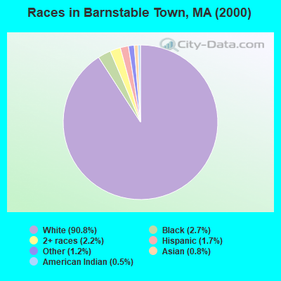
Races in Barnstable Town detailed stats: ancestries, foreign born residents, place of birth
 Recent articles from our blog. Our writers, many of them Ph.D. graduates or candidates, create easy-to-read articles on a wide variety of topics.


Latest news from Barnstable Town, MA collected exclusively by city-data.com from local newspapers, TV, and radio stations
Ancestries: Irish (28.2%), English (17.7%), Italian (11.1%), German (7.9%), French (6.4%), United States (4.7%).
Current Local Time: EST time zone
Land area: 60.0 square miles.
Population density: 793 people per square mile (low).
3,322 residents are foreign born (2.9% Latin America, 2.3% Europe, 0.8% Asia, 0.7% North America).
| This city: | 6.9% |
| Massachusetts: | 12.2% |
| Barnstable Town city: | 1.1% ($1,936) |
| Massachusetts: | 1.3% ($2,336) |
Nearest city with pop. 50,000+: New Bedford, MA  (30.0 miles , pop. 93,768).
Nearest city with pop. 200,000+: Boston, MA (59.4 miles , pop. 589,141).
Nearest city with pop. 1,000,000+: Bronx, NY (191.5 miles , pop. 1,332,650).
Nearest cities:
), ), )Latitude: 41.66 N, Longitude: 70.35 W
Daytime population change due to commuting: +2,763 (+5.8%)
Workers who live and work in this city: 12,147 (54.8%)
Property values in Barnstable Town, MA
Barnstable Town tourist attractions:
| Here: | 4.2% |
| Massachusetts: | 3.5% |
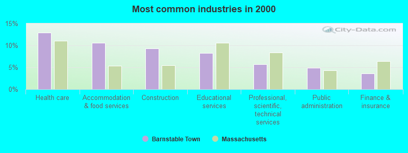
- Health care (12.9%)
- Accommodation & food services (10.6%)
- Construction (9.3%)
- Educational services (8.3%)
- Professional, scientific, technical services (5.7%)
- Public administration (4.9%)
- Finance & insurance (3.6%)
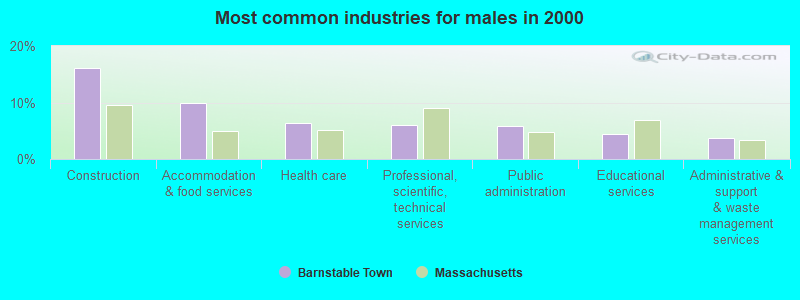
- Construction (16.1%)
- Accommodation & food services (9.9%)
- Health care (6.4%)
- Professional, scientific, technical services (6.0%)
- Public administration (5.8%)
- Educational services (4.5%)
- Administrative & support & waste management services (3.7%)
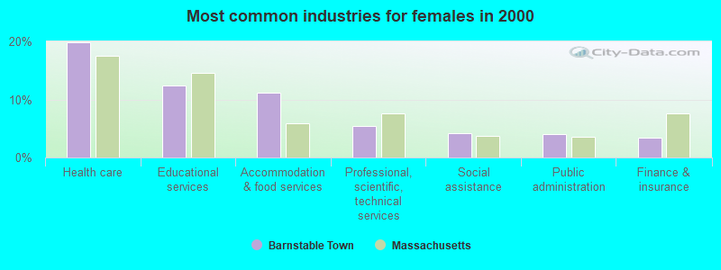
- Health care (19.8%)
- Educational services (12.4%)
- Accommodation & food services (11.2%)
- Professional, scientific, technical services (5.4%)
- Social assistance (4.2%)
- Public administration (4.0%)
- Finance & insurance (3.4%)
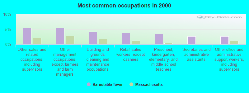
- Other sales and related occupations, including supervisors (5.4%)
- Other management occupations, except farmers and farm managers (5.4%)
- Building and grounds cleaning and maintenance occupations (4.2%)
- Retail sales workers, except cashiers (3.8%)
- Preschool, kindergarten, elementary, and middle school teachers (3.5%)
- Secretaries and administrative assistants (2.7%)
- Other office and administrative support workers, including supervisors (2.7%)
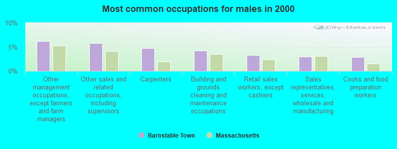
- Other management occupations, except farmers and farm managers (6.1%)
- Other sales and related occupations, including supervisors (5.8%)
- Carpenters (4.7%)
- Building and grounds cleaning and maintenance occupations (4.2%)
- Retail sales workers, except cashiers (3.3%)
- Sales representatives, services, wholesale and manufacturing (3.0%)
- Cooks and food preparation workers (2.9%)
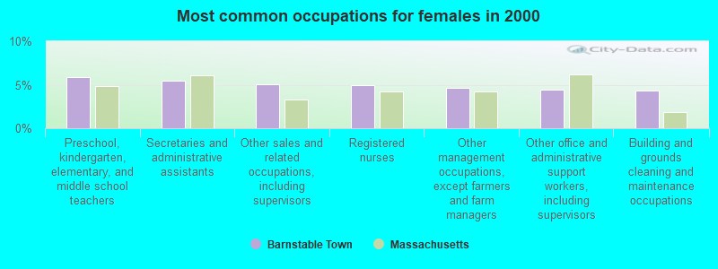
- Preschool, kindergarten, elementary, and middle school teachers (5.8%)
- Secretaries and administrative assistants (5.5%)
- Other sales and related occupations, including supervisors (5.1%)
- Registered nurses (4.9%)
- Other management occupations, except farmers and farm managers (4.7%)
- Other office and administrative support workers, including supervisors (4.5%)
- Building and grounds cleaning and maintenance occupations (4.3%)
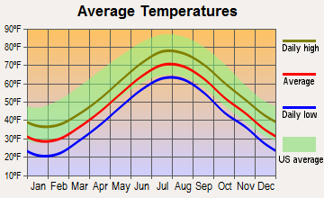
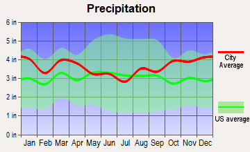
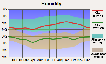
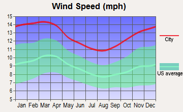
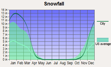
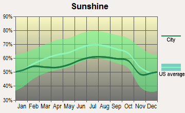
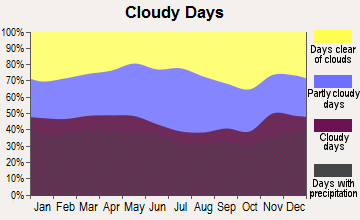
Average climate in Barnstable Town, Massachusetts
Based on data reported by over 4,000 weather stations
Earthquake activity:
Barnstable Town-area historical earthquake activity is significantly above Massachusetts state average. It is 77% smaller than the overall U.S. average.On 10/16/2012 at 23:12:25, a magnitude 4.7 (4.7 ML, Depth: 10.0 mi, Class: Light, Intensity: IV - V) earthquake occurred 134.9 miles away from the city center
On 10/7/1983 at 10:18:46, a magnitude 5.3 (5.1 MB, 5.3 LG, 5.1 ML, Class: Moderate, Intensity: VI - VII) earthquake occurred 257.1 miles away from Barnstable Town center
On 4/20/2002 at 10:50:47, a magnitude 5.3 (5.3 ML, Depth: 3.0 mi) earthquake occurred 259.7 miles away from the city center
On 1/19/1982 at 00:14:42, a magnitude 4.7 (4.5 MB, 4.7 MD, 4.5 LG) earthquake occurred 142.3 miles away from the city center
On 8/22/1992 at 12:20:32, a magnitude 4.8 (4.8 MB, 3.8 MS, 4.7 LG, Depth: 6.2 mi) earthquake occurred 176.6 miles away from Barnstable Town center
On 4/20/2002 at 10:50:47, a magnitude 5.2 (5.2 MB, 4.2 MS, 5.2 MW, 5.0 MW) earthquake occurred 259.1 miles away from the city center
Magnitude types: regional Lg-wave magnitude (LG), body-wave magnitude (MB), duration magnitude (MD), local magnitude (ML), surface-wave magnitude (MS), moment magnitude (MW)
Natural disasters:
The number of natural disasters in Barnstable County (21) is greater than the US average (15).Major Disasters (Presidential) Declared: 11
Emergencies Declared: 8
Causes of natural disasters: Hurricanes: 7, Floods: 5, Storms: 4, Snows: 3, Snowstorms: 3, Winter Storms: 3, Blizzards: 2, Snowfall: 1, Tropical Storm: 1, Wind: 1, Other: 1 (Note: some incidents may be assigned to more than one category).
Hospitals and medical centers near Barnstable Town:
- CENTERVILLE NURSING HOME (Nursing Home, about 1 miles away; CENTERVILLE, MA)
- CAPE REGENCY, A RADIUS HEALTHCARE CENTER (Nursing Home, about 1 miles away; CENTERVILLE, MA)
- PAVILION , THE (Nursing Home, about 2 miles away; HYANNIS, MA)
- CAPE COD HOSP EXTD CARE COMMUN MANOR (Nursing Home, about 2 miles away; HYANNIS, MA)
- CAPE REGENCY NURSING HOME (Nursing Home, about 4 miles away; BARNSTABLE, MA)
- BAYADA NURSES (Home Health Center, about 4 miles away; HYANNIS, MA)
- HOSPICE AND PALLIATIVE CARE OF CAPE COD (Hospital, about 4 miles away; HYANNIS, MA)
Colleges/universities with over 2000 students nearest to Barnstable Town:
- Cape Cod Community College (about 3 miles; West Barnstable, MA; Full-time enrollment: 2,491)
- University of Massachusetts-Dartmouth (about 34 miles; North Dartmouth, MA; FT enrollment: 7,545)
- Bridgewater State University (about 39 miles; Bridgewater, MA; FT enrollment: 9,802)
- Bristol Community College (about 40 miles; Fall River, MA; FT enrollment: 5,707)
- Massasoit Community College (about 44 miles; Brockton, MA; FT enrollment: 5,442)
- Stonehill College (about 47 miles; Easton, MA; FT enrollment: 2,563)
- Roger Williams University (about 47 miles; Bristol, RI; FT enrollment: 4,375)
Points of interest:
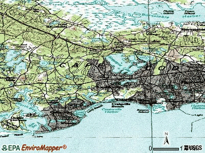
Notable locations in Barnstable Town: Maraspin Creek Entrance Light (A), Yarmouth Campgrounds (B), Capetown Plaza (C), Barnstable County Fairgrounds (D), Benjamin Marstons Mill Site (E), Barnstable Municipal Airport Aero Light (F), West Barnstable Station (G), Centerville - Osterville- Marstons Mills Fire District Marston Mills (H), Hyannis Fire Department (I), West Barnstable Fire Department (J), Centerville - Osterville - Marstons Mills Fire District Centerville Headquarters (K), Barnstable Fire Department (L), Centerville - Osterville - Marstons Mills Fire District Osterville (M), Cotuit Fire District (N), Donald G Trayer Museum (O), Osterville Free Library (P), Sandy Neck Light (Q), Old Parsonage (R), Sturgis Library (S), Barnstable County Court House (T). Display/hide their locations on the map
Shopping Centers: Airport Shopping Center (1), Capetown Shopping Center (2), Centerville Shopping Center (3), All Cape Shopping Center Picture Pond Plaza (4), Cape Cod Mall (5). Display/hide their locations on the map
Churches in Barnstable Town include: Covenant On The Rock Family Church (A), Saint Marys Church (B), West Parrish Church (C), Saint Judes Chapel (D), Saint Francis Xavier Church (E), Osterville Baptist Church (F), Assembleia De Deus (G), South Congregational Church (H). Display/hide their locations on the map
Cemeteries: Oak Neck Cemetery (1), Oak Grove Cemetery (2), Saint Francis Xaviers Cemetery (3), Beechwood Cemetery (4), East Barnstable Cemetery (5), Lothrop Hill Cemetery (6), Crocker Cemetery (7). Display/hide their locations on the map
Lakes and swamps: Mill Pond (A), West Pond (B), Naomi Pond (C), North Pond (D), Small Pond (E), Scudder Bay (F), Wequaquet Lake (G), Spruce Pond (H). Display/hide their locations on the map
Rivers and creeks: Rendezvous Creek (A), Scorton Creek (B), Spring Creek (C), Snows Creek (D), Through Creek (E), Wells Creek (F), Smith Creek (G), Marstons Mill River (H), Halls Creek (I). Display/hide their locations on the map
Parks in Barnstable Town include: John F Kennedy Memorial (1), Kennedy Compound (2), Lowell Park (3), Veterans Memorial Park (4), Kalmus Park Beach (5), Bodfish Park (6), Town of Barnstable Public Lands (7), Sampsons Island Sanctuary (8). Display/hide their locations on the map
Beaches: Wianno Beach (A), Dowses Beach (B), Keyes Memorial Beach (C), Kalmus Park Beach (D), Lewis Bay Beach (E), Veterans Park Beach (F), Kalmas Park Beach (G). Display/hide their locations on the map
| This city: | 2.4 people |
| Massachusetts: | 2.5 people |
| This city: | 66.3% |
| Whole state: | 65.0% |
| This city: | 4.7% |
| Whole state: | 5.4% |
Likely homosexual households (counted as self-reported same-sex unmarried-partner households)
- Lesbian couples: 0.3% of all households
- Gay men: 0.3% of all households
| This city: | 8.8% |
| Whole state: | 9.3% |
| This city: | 4.0% |
| Whole state: | 4.4% |
People in group quarters in Barnstable Town in 2000:
- 328 people in nursing homes
- 266 people in local jails and other confinement facilities (including police lockups)
- 255 people in other noninstitutional group quarters
- 98 people in other workers' dormitories
- 95 people in homes for the mentally retarded
- 69 people in other group homes
- 52 people in homes for the mentally ill
- 24 people in homes for the physically handicapped
- 6 people in hospitals/wards and hospices for chronically ill
- 6 people in hospices or homes for chronically ill
- 6 people in homes or halfway houses for drug/alcohol abuse
- 5 people in religious group quarters
For population 15 years and over in Barnstable Town:
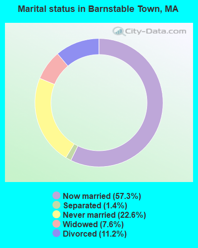
- Never married: 22.6%
- Now married: 57.3%
- Separated: 1.4%
- Widowed: 7.6%
- Divorced: 11.2%
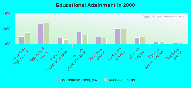
For population 25 years and over in Barnstable Town:
- High school or higher: 90.4%
- Bachelor's degree or higher: 32.2%
- Graduate or professional degree: 11.9%
- Unemployed: 4.8%
- Mean travel time to work (commute): 23.7 minutes

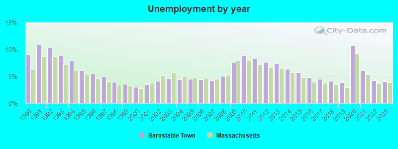
| Here: | 10.4 |
| Massachusetts average: | 13.1 |
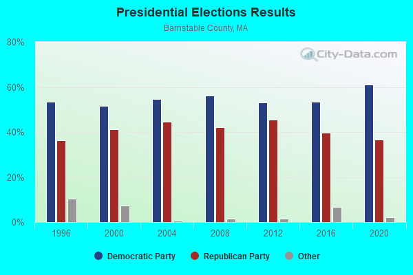
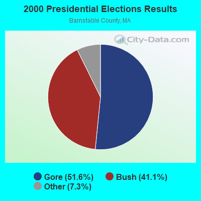

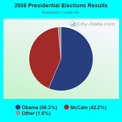

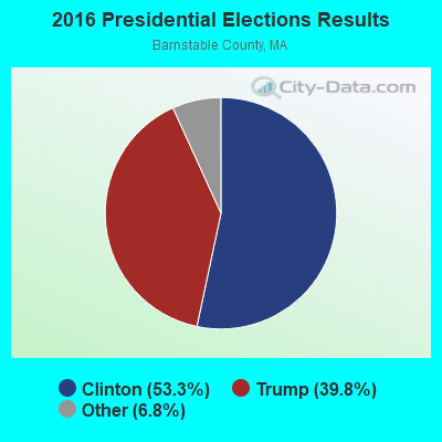
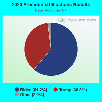
Graphs represent county-level data. Detailed 2008 Election Results
Religion statistics for Barnstable Town, MA (based on Barnstable County data)
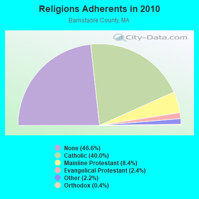
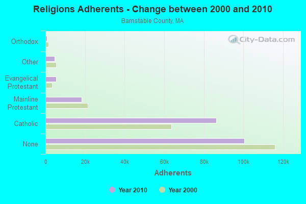
| Religion | Adherents | Congregations |
|---|---|---|
| Catholic | 86,370 | 18 |
| Mainline Protestant | 18,165 | 68 |
| Evangelical Protestant | 5,281 | 46 |
| Other | 4,734 | 32 |
| Orthodox | 810 | 3 |
| None | 100,528 | - |
Food Environment Statistics:
| Barnstable County: | 3.06 / 10,000 pop. |
| Massachusetts: | 1.98 / 10,000 pop. |
| This county: | 0.05 / 10,000 pop. |
| State: | 0.05 / 10,000 pop. |
| Barnstable County: | 3.38 / 10,000 pop. |
| Massachusetts: | 2.22 / 10,000 pop. |
| Barnstable County: | 2.57 / 10,000 pop. |
| State: | 1.77 / 10,000 pop. |
| Here: | 18.60 / 10,000 pop. |
| State: | 8.76 / 10,000 pop. |
| This county: | 7.9% |
| Massachusetts: | 8.1% |
| Barnstable County: | 19.6% |
| Massachusetts: | 22.5% |
| This county: | 13.8% |
| State: | 16.5% |
Barnstable Town government finances - Expenditure in 2004 (per resident):
- Construction - Air Transportation: $4,465,000 ($93.79)
General: $1,742,000 ($36.59)
General Public Buildings: $1,200,000 ($25.21)
- Current Operations - Elementary and Secondary Education: $61,876,000 ($1299.72)
Police Protection: $9,556,000 ($200.73)
General - Other: $8,801,000 ($184.87)
Parks and Recreation: $3,796,000 ($79.74)
Air Transportation: $3,777,000 ($79.34)
Regular Highways: $3,350,000 ($70.37)
Financial Administration: $3,185,000 ($66.90)
General Public Buildings: $2,764,000 ($58.06)
Sewerage: $2,345,000 ($49.26)
Protective Inspection and Regulation - Other: $1,635,000 ($34.34)
Central Staff Services: $1,373,000 ($28.84)
Libraries: $1,366,000 ($28.69)
Solid Waste Management: $1,081,000 ($22.71)
Health Services - Other: $500,000 ($10.50)
Judicial and Legal Services: $457,000 ($9.60)
Housing and Community Development: $323,000 ($6.78)
Natural Resources - Other: $263,000 ($5.52)
Welfare - Other: $235,000 ($4.94)
Parking Facilities: $1,000 ($0.02)
- General - Interest on Debt: $5,011,000 ($105.26)
- Intergovernmental to Local - Other - Elementary and Secondary Education: $2,127,000 ($44.68)
Other - Health: $262,000 ($5.50)
- Intergovernmental to State - Elementary and Secondary Education: $1,118,000 ($23.48)
Transit Utilities: $331,000 ($6.95)
General: $68,000 ($1.43)
- Other Capital Outlay - General - Other: $16,793,000 ($352.74)
Regular Highways: $852,000 ($17.90)
Elementary and Secondary Education: $284,000 ($5.97)
Police Protection: $278,000 ($5.84)
General Public Building: $131,000 ($2.75)
Parks and Recreation: $80,000 ($1.68)
Protective Inspection and Regulation - Other: $9,000 ($0.19)
- Total Salaries and Wages: $66,064,000 ($1387.70)
Barnstable Town government finances - Revenue in 2004 (per resident):
- Charges - Air Transportation: $4,286,000 ($90.03)
Sewerage: $3,827,000 ($80.39)
Parks and Recreation: $3,320,000 ($69.74)
Other: $1,920,000 ($40.33)
Solid Waste Management: $1,523,000 ($31.99)
Elementary and Secondary Education School Lunch: $1,181,000 ($24.81)
Elementary and Secondary Education School Tuition: $969,000 ($20.35)
Elementary and Secondary Education - Other: $156,000 ($3.28)
Parking Facilities: $33,000 ($0.69)
- Federal Intergovernmental - Other: $4,566,000 ($95.91)
Housing and Community Development: $375,000 ($7.88)
Education: $146,000 ($3.07)
- Local Intergovernmental - Education: $236,000 ($4.96)
- Miscellaneous - General Revenue - Other: $1,963,000 ($41.23)
Interest Earnings: $655,000 ($13.76)
Special Assessments: $2,000 ($0.04)
- State Intergovernmental - Education: $15,973,000 ($335.52)
Other: $3,588,000 ($75.37)
General Support: $1,988,000 ($41.76)
Highways: $441,000 ($9.26)
Water Utilities: $250,000 ($5.25)
Public Welfare: $62,000 ($1.30)
- Tax - Property: $80,278,000 ($1686.26)
Other Selective Sales: $1,861,000 ($39.09)
Other: $1,347,000 ($28.29)
Barnstable Town government finances - Debt in 2004 (per resident):
- Long Term Debt - Outstanding - Full Faith and Credit - Other - Other: $66,462,000 ($1396.06)
Beginning Outstanding, Education - Other: $64,692,000 ($1358.88)
Outstanding - Full Faith and Credit - Elementary and Secondary Education: $60,741,000 ($1275.88)
Beginning Outstanding - Other: $55,258,000 ($1160.71)
Issue, Unspecified - Other - Other: $16,961,000 ($356.27)
Retired Unspecified - Other - Other: $5,757,000 ($120.93)
Retired Unspecified - Elementary and Secondary Education: $3,951,000 ($82.99)
Issue, Unspecified - Elementary and Secondary Education: $0 ($0.00)
- Short Term Debt Outstanding - Beginning: $1,850,000 ($38.86)
End of Fiscal Year: $1,850,000 ($38.86)
Barnstable Town government finances - Cash and Securities in 2004 (per resident):
- Bond Fund - Cash and Deposits: $9,312,000 ($195.60)
- Other Funds - Cash and Deposits: $49,612,000 ($1042.12)
- Sinking Fund - Cash and Deposits: $11,541,000 ($242.42)
Strongest AM radio stations in Barnstable Town:
- WBUR (1240 AM; 1 kW; WEST YARMOUTH, MA; Owner: THE EXEC. COMM. OF TRTS. BOSTON U)
- WBZ (1030 AM; 50 kW; BOSTON, MA; Owner: INFINITY BROADCASTING OPERATIONS, INC.)
- WEEI (850 AM; 50 kW; BOSTON, MA; Owner: ENTERCOM BOSTON LICENSE, LLC)
- WRKO (680 AM; 50 kW; BOSTON, MA; Owner: ENTERCOM BOSTON LICENSE, LLC)
- WALE (990 AM; 50 kW; GREENVILLE, RI; Owner: NORTH AMERICAN BROADCASTING CO., INC.)
- WKOX (1200 AM; 50 kW; FRAMINGHAM, MA; Owner: CAPSTAR TX LIMITED PARTNERSHIP)
- WWZN (1510 AM; 50 kW; BOSTON, MA; Owner: ROSE CITY RADIO CORPORATION)
- WBIX (1060 AM; 40 kW; NATICK, MA; Owner: LANGER BROADCASTING CORPORATION)
- WCRN (830 AM; 50 kW; WORCESTER, MA; Owner: CARTER BROADCASTING CORPORATION)
- WAMG (890 AM; 25 kW; DEDHAM, MA; Owner: MEGA COMMUNICATIONS OF DEDHAM LICENSEE, LLC)
- WPLM (1390 AM; 5 kW; PLYMOUTH, MA; Owner: PLYMOUTH ROCK BROADCASTING CO., INC.)
- WNNZ (640 AM; 50 kW; WESTFIELD, MA; Owner: CLEAR CHANNEL BROADCASTING LICENSES, INC.)
- WRCA (1330 AM; 25 kW; WALTHAM, MA; Owner: WRCA LICENSE, LLC)
Strongest FM radio stations in Barnstable Town:
- WPXC (102.9 FM; HYANNIS, MA; Owner: QANTUM OF CAPE COD LICENSE COMPANY, LLC)
- WQRC (99.9 FM; BARNSTABLE, MA; Owner: SANDAB COMMUNICATION LTD. PNR/SHP II)
- WKKL (90.7 FM; WEST BARNSTABLE, MA; Owner: CAPE COD COMMUNITY COLLEGE)
- WXTK (95.1 FM; WEST YARMOUTH, MA; Owner: BOCH BROADCASTING LTD. PARTNERSHIP)
- WCOD-FM (106.1 FM; HYANNIS, MA; Owner: BOCH BROADCASTING, L.P.)
- WOCN-FM (103.9 FM; SOUTH YARMOUTH, MA; Owner: SANDAB COMMUNICATIONS LTD. PARTNERSHIP II)
- WCIB (101.9 FM; FALMOUTH, MA; Owner: QANTUM OF CAPE COD LICENSE COMPANY, LLC)
- WSDH (91.5 FM; SANDWICH, MA; Owner: SANDWICH MASS. PUBLIC SCHOOLS)
- WTWV (101.1 FM; MASHPEE, MA; Owner: BOCH BROADCASTING, L.P.)
- WKPE-FM (104.7 FM; ORLEANS, MA; Owner: CRB WKPE LIC CORP.)
- WFPB-FM (91.9 FM; FALMOUTH, MA; Owner: UNIVERSITY OF MASSACHUSETTS)
- WFCC-FM (107.5 FM; CHATHAM, MA; Owner: CHARLES RIVER B/CING WFCC LIC. CORP.)
- WDVT (93.5 FM; HARWICH PORT, MA; Owner: BOCH BROADCASTING, L.P.)
- WJFD-FM (97.3 FM; NEW BEDFORD, MA; Owner: EDMUND DINIS, TRUSTEE)
- WMVY (92.7 FM; TISBURY, MA; Owner: ARITAUR COMMUNICATIONS, INC.)
- WCTK (98.1 FM; NEW BEDFORD, MA; Owner: HALL COMMUNICATIONS, INC.)
- WPLM-FM (99.1 FM; PLYMOUTH, MA; Owner: PLYMOUTH ROCK BROADCASTING CO., INC.)
- WRZE (96.3 FM; NANTUCKET, MA; Owner: QANTUM OF CAPE COD LICENSE COMPANY, LLC)
- WCAI (90.1 FM; WOODS HOLE, MA; Owner: WGBH EDUCATIONAL FOUNDATION)
- WCCT-FM (90.3 FM; HARWICH, MA; Owner: CAPE COD REGIONAL TECH HIGH SCHOOL)
TV broadcast stations around Barnstable Town:
- WDPX (Channel 58; VINEYARD HAVEN, MA; Owner: PAXSON BOSTON-68 LICENSE, INC.)
- WMPX-LP (Channel 67; DENNIS, MA; Owner: PAXSON BOSTON-68 LICENSE, INC.)
- W08CH (Channel 8; HYANNIS, MA; Owner: WGBH EDUCATIONAL FOUNDATION)
- WLWC (Channel 28; NEW BEDFORD, MA; Owner: C-28 FCC LICENSEE SUBSIDIARY, LLC)
- WWDP (Channel 46; NORWELL, MA; Owner: NORWELL TELEVISION, LLC)
- National Bridge Inventory (NBI) Statistics
- 13Number of bridges
- 125ft / 38.4mTotal length
- $23,726,000Total costs
- 188,595Total average daily traffic
- 14,079Total average daily truck traffic
- 495,585Total future (year 2031) average daily traffic
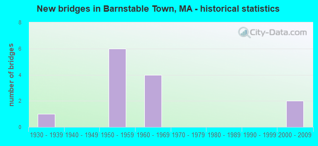
- New bridges - historical statistics
- 11930-1939
- 61950-1959
- 41960-1969
- 22000-2009
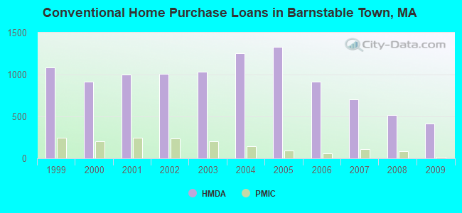
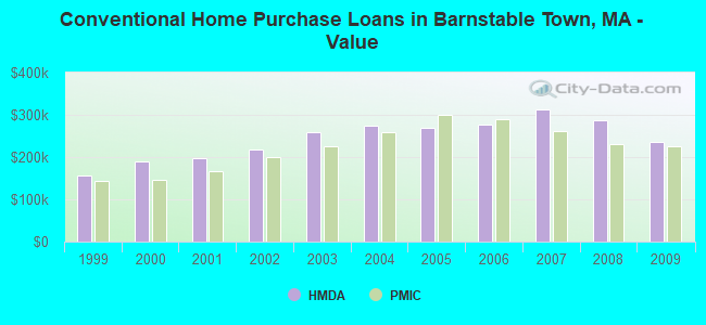
| Home Mortgage Disclosure Act Aggregated Statistics For Year 2009 (Based on 11 full tracts) | ||||||||||||
| A) FHA, FSA/RHS & VA Home Purchase Loans | B) Conventional Home Purchase Loans | C) Refinancings | D) Home Improvement Loans | E) Loans on Dwellings For 5+ Families | F) Non-occupant Loans on < 5 Family Dwellings (A B C & D) | |||||||
|---|---|---|---|---|---|---|---|---|---|---|---|---|
| Number | Average Value | Number | Average Value | Number | Average Value | Number | Average Value | Number | Average Value | Number | Average Value | |
| LOANS ORIGINATED | 140 | $222,671 | 415 | $235,863 | 1,760 | $264,061 | 125 | $157,336 | 1 | $198,000 | 590 | $296,864 |
| APPLICATIONS APPROVED, NOT ACCEPTED | 7 | $165,714 | 25 | $266,880 | 89 | $365,697 | 11 | $90,727 | 0 | $0 | 40 | $511,925 |
| APPLICATIONS DENIED | 36 | $197,194 | 56 | $271,482 | 476 | $315,008 | 46 | $205,370 | 0 | $0 | 122 | $399,426 |
| APPLICATIONS WITHDRAWN | 19 | $230,579 | 46 | $224,022 | 263 | $281,065 | 5 | $267,800 | 0 | $0 | 64 | $335,547 |
| FILES CLOSED FOR INCOMPLETENESS | 5 | $241,800 | 9 | $278,111 | 99 | $260,020 | 3 | $30,000 | 0 | $0 | 21 | $284,667 |
Detailed mortgage data for all 11 tracts in Barnstable Town, MA
| Private Mortgage Insurance Companies Aggregated Statistics For Year 2009 (Based on 11 full tracts) | ||||||
| A) Conventional Home Purchase Loans | B) Refinancings | C) Non-occupant Loans on < 5 Family Dwellings (A & B) | ||||
|---|---|---|---|---|---|---|
| Number | Average Value | Number | Average Value | Number | Average Value | |
| LOANS ORIGINATED | 21 | $226,571 | 17 | $266,294 | 6 | $258,667 |
| APPLICATIONS APPROVED, NOT ACCEPTED | 3 | $249,667 | 12 | $305,667 | 0 | $0 |
| APPLICATIONS DENIED | 3 | $209,000 | 9 | $259,000 | 2 | $190,500 |
| APPLICATIONS WITHDRAWN | 1 | $383,000 | 1 | $264,000 | 1 | $264,000 |
| FILES CLOSED FOR INCOMPLETENESS | 2 | $237,000 | 2 | $221,000 | 0 | $0 |
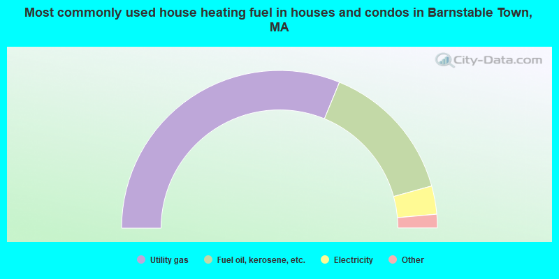
- 62.4%Utility gas
- 29.0%Fuel oil, kerosene, etc.
- 5.8%Electricity
- 1.5%Bottled, tank, or LP gas
- 0.9%Wood
- 0.3%Coal or coke

- 57.7%Utility gas
- 20.8%Electricity
- 18.3%Fuel oil, kerosene, etc.
- 2.5%Bottled, tank, or LP gas
- 0.7%Wood
- 0.1%No fuel used
Barnstable Town compared to Massachusetts state average:
- Unemployed percentage significantly below state average.
- Black race population percentage below state average.
- Hispanic race population percentage significantly below state average.
- Foreign-born population percentage significantly below state average.
- Renting percentage significantly below state average.
- Length of stay since moving in significantly above state average.
- Number of rooms per house significantly below state average.
- House age significantly below state average.
- Institutionalized population percentage significantly above state average.
- Number of college students below state average.
Barnstable Town on our top lists:
- #16 on the list of "Top 101 cities with the largest percentage of one, detached housing units in structures (20,000+ housing units)"
- #34 on the list of "Top 101 cities with the biggest property tax revenues per resident (population 10,000+)"
- #57 on the list of "Top 101 cities with largest percentage of males in occupations: air transportation workers (population 5,000+)"
- #69 on the list of "Top 101 cities with largest percentage of males in occupations: carpenters (population 5,000+)"
- #71 on the list of "Top 101 cities with largest percentage of males in occupations: painters and paperhangers (population 5,000+)"
- #74 on the list of "Top 101 cities with the most residents born in Brazil (population 500+)"
- #79 on the list of "Top 101 cities with largest percentage of males in occupations: information and record clerks except customer service representatives (population 5,000+)"
- #79 on the list of "Top 101 cities with largest percentage of females in occupations: pipelayers, plumbers, pipefitters, and steamfitters (population 5,000+)"
- #82 on the list of "Top 101 cities with largest percentage of males in occupations: special education teachers (population 5,000+)"
- #92 on the list of "Top 101 cities with largest percentage of males in industries: religious, grantmaking, civic, professional, and similar organizations (population 5,000+)"
- #94 on the list of "Top 101 cities with largest percentage of females in industries: sewing, needlework, and piece goods stores (population 5,000+)"
- #1 on the list of "Top 101 counties with the highest percentage of residents that smoked 100+ cigarettes in their lives"
- #7 on the list of "Top 101 counties with the lowest number of births per 1000 residents 2007-2013"
- #9 on the list of "Top 101 counties with the highest percentage of residents that visited a dentist within the past year"
- #10 on the list of "Top 101 counties with the lowest average weight of females"
- #24 on the list of "Top 101 counties with the largest number of people without health insurance coverage in 2000 (pop. 50,000+)"