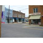
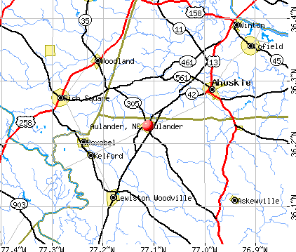
Aulander, North Carolina
Aulander: Shop for Antiques and furnature in Aulander
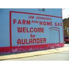
Aulander: Welcome to Aulander
Aulander: Eat homemade food 4miles from the center of Aulander
- add
your
Submit your own pictures of this town and show them to the world
- OSM Map
- General Map
- Google Map
- MSN Map
Population change since 2000: -18.1%
 |
| Males: 338 | |
| Females: 389 |
| Median resident age: | 42.5 years |
| North Carolina median age: | 39.2 years |
Zip codes: 27805.
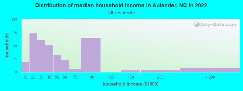
| Aulander: | $33,901 |
| NC: | $67,481 |
Estimated per capita income in 2022: $25,213 (it was $13,767 in 2000)
Aulander town income, earnings, and wages data
Estimated median house or condo value in 2022: $99,745 (it was $55,800 in 2000)
| Aulander: | $99,745 |
| NC: | $280,600 |
Mean prices in 2022: all housing units: $90,452; detached houses: $109,061; mobile homes: $21,537
Median gross rent in 2022: $656.
(7.8% for White Non-Hispanic residents, 15.6% for Black residents)
Detailed information about poverty and poor residents in Aulander, NC
Compare current foreclosures near Aulander, NC:
| Photo | Address | Area | Beds / Baths | Price | Details |
|---|---|---|---|---|---|

|
#1
Hollowell Rd
Aulander, NC 27805
|
2,440 sq. feet
|
2 baths 4 beds |
show details | |

|
#2
Charles Taylor Rd
Aulander, NC 27805
|
1,776 sq. feet
|
2 baths 3 beds |
show details | |

|
#3
Bruce Farmer Rd
Aulander, NC 27805
|
- sq. feet
|
- baths - beds |
show details | |

|
#4
Caroline St
Aulander, NC 27805
|
- sq. feet
|
- baths - beds |
show details | |

|
#5
Millennium Rd
Aulander, NC 27805
|
- sq. feet
|
- baths - beds |
show details | |

|
#6
Hancock St
Lewiston Woodville, NC 27849
|
1,617 sq. feet
|
1 baths 3 beds |
$210,000
|
show details |

|
#7
Hazel St
Woodland, NC 27897
|
- sq. feet
|
- baths - beds |
$23,900
|
show details |

|
#8
Mount Olive Rd
Windsor, NC 27983
|
1,488 sq. feet
|
2 baths 3 beds |
show details | |

|
#9
E Vance St
Murfreesboro, NC 27855
|
1,160 sq. feet
|
- baths - beds |
$12,900
|
show details |

|
#10
Us 13 N
Windsor, NC 27983
|
1,800 sq. feet
|
2 baths 3 beds |
show details |
| Photo | Address | Area | Beds / Baths | Price | Details |
|---|---|---|---|---|---|

|
#11
Blue Foot Rd
Ahoskie, NC 27910
|
2,356 sq. feet
|
2 baths 4 beds |
show details | |

|
#12
Vinson Mill Rd
Murfreesboro, NC 27855
|
1,092 sq. feet
|
1 baths 3 beds |
show details | |

|
#13
Willoughby Rd
Ahoskie, NC 27910
|
1,620 sq. feet
|
2 baths 5 beds |
show details | |

|
#14
Vaughan Town Rd
Murfreesboro, NC 27855
|
864 sq. feet
|
2 baths 3 beds |
show details | |

|
#15
D T Rd
Ahoskie, NC 27910
|
1,568 sq. feet
|
2 baths 3 beds |
show details | |

|
#16
Dilday Rd
Colerain, NC 27924
|
1,572 sq. feet
|
2 baths 3 beds |
show details | |

|
#17
Cremo Rd
Colerain, NC 27924
|
1,520 sq. feet
|
1 baths 3 beds |
show details | |

|
#18
Daily Rd
Ahoskie, NC 27910
|
1,678 sq. feet
|
2 baths 4 beds |
show details | |

|
#19
Raleigh St
Murfreesboro, NC 27855
|
2,398 sq. feet
|
3 baths 4 beds |
show details | |

|
#20
Mckinley Dr W
Ahoskie, NC 27910
|
1,695 sq. feet
|
1 baths 3 beds |
show details |
| Photo | Address | Area | Beds / Baths | Price | Details |
|---|---|---|---|---|---|

|
#21
N West Rd
Murfreesboro, NC 27855
|
912 sq. feet
|
1 baths 2 beds |
show details | |

|
#22
Ahoskie Cofield Rd
Ahoskie, NC 27910
|
1,344 sq. feet
|
2 baths 3 beds |
show details | |

|
#23
Piney Woods Rd # C
Lewiston Woodville, NC 27849
|
1,125 sq. feet
|
1 baths 3 beds |
show details | |

|
#24
Fretwell Rd
Ahoskie, NC 27910
|
1,728 sq. feet
|
2 baths 3 beds |
show details | |

|
#25
Glovers Cross Rd
Colerain, NC 27924
|
1,792 sq. feet
|
2 baths 3 beds |
show details | |

|
#26
Garfield Mitchell Rd
Ahoskie, NC 27910
|
1,120 sq. feet
|
1 baths 3 beds |
show details | |

|
#27
Carlyle Askew Ln
Ahoskie, NC 27910
|
1,080 sq. feet
|
2 baths 3 beds |
show details | |

|
#28
W Saluda Hall Rd
Ahoskie, NC 27910
|
1,488 sq. feet
|
2 baths 3 beds |
show details | |

|
#29
William Parker Rd
Murfreesboro, NC 27855
|
1,378 sq. feet
|
- baths 3 beds |
show details | |

|
#30
N 3rd St
Murfreesboro, NC 27855
|
616 sq. feet
|
2 baths - beds |
show details |
| Photo | Address | Area | Beds / Baths | Price | Details |
|---|---|---|---|---|---|

|
#31
Phillips Hill Rd
Conway, NC 27820
|
1,848 sq. feet
|
- baths 3 beds |
show details | |

|
#32
Martin St
Conway, NC 27820
|
1,198 sq. feet
|
- baths 3 beds |
show details | |

|
#33
Wj Duke Service Rd
Rich Square, NC 27869
|
667 sq. feet
|
- baths 4 beds |
show details | |

|
#34
Us Highway 158
Conway, NC 27820
|
1,748 sq. feet
|
- baths 6 beds |
show details | |

|
#35
Cooke Cir
Rich Square, NC 27869
|
1,120 sq. feet
|
- baths 3 beds |
show details | |

|
#36
Spruce St
Woodland, NC 27897
|
1,084 sq. feet
|
- baths 3 beds |
show details | |

|
#37
Academy St N
Ahoskie, NC 27910
|
1,260 sq. feet
|
- baths 3 beds |
show details | |

|
#38
Nc Highway 305
Rich Square, NC 27869
|
912 sq. feet
|
- baths 3 beds |
show details | |

|
#39
Church St W
Ahoskie, NC 27910
|
1,455 sq. feet
|
- baths 3 beds |
show details | |

|
#40
Us Highway 258
Rich Square, NC 27869
|
1,932 sq. feet
|
- baths 4 beds |
show details |
| Photo | Address | Area | Beds / Baths | Price | Details |
|---|---|---|---|---|---|

|
#41
S 4th St
Murfreesboro, NC 27855
|
- sq. feet
|
- baths - beds |
show details | |

|
#42
Pecan Dr
Murfreesboro, NC 27855
|
- sq. feet
|
- baths - beds |
show details | |

|
#43
Colony Ave N
Ahoskie, NC 27910
|
- sq. feet
|
- baths - beds |
show details | |

|
#44
Harrell St
Murfreesboro, NC 27855
|
- sq. feet
|
- baths - beds |
show details | |

|
#45
Eleytown Rd
Murfreesboro, NC 27855
|
- sq. feet
|
- baths - beds |
show details | |

|
#46
E High St
Murfreesboro, NC 27855
|
- sq. feet
|
- baths - beds |
show details | |

|
#47
Wakelon Rd
Colerain, NC 27924
|
- sq. feet
|
- baths - beds |
show details | |

|
#48
West St S
Ahoskie, NC 27910
|
- sq. feet
|
- baths - beds |
show details | |

|
#49
Hillside Dr
Rich Square, NC 27869
|
- sq. feet
|
- baths - beds |
show details | |

|
Check over 1 million property listings on Foreclosure.com!
|
browse all offers | |||


- 44061.2%Black alone
- 25635.6%White alone
- 81.1%Two or more races
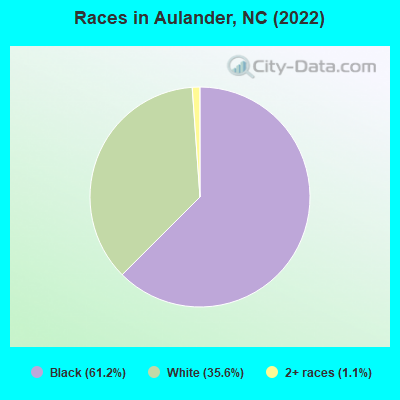
Races in Aulander detailed stats: ancestries, foreign born residents, place of birth
According to our research of North Carolina and other state lists, there were 15 registered sex offenders living in Aulander, North Carolina as of May 28, 2024.
The ratio of all residents to sex offenders in Aulander is 58 to 1.
Type |
2009 |
2010 |
2011 |
2012 |
2013 |
2014 |
2015 |
2016 |
|---|---|---|---|---|---|---|---|---|
| Murders (per 100,000) | 0 (0.0) | 0 (0.0) | 0 (0.0) | 0 (0.0) | 0 (0.0) | 0 (0.0) | 0 (0.0) | 0 (0.0) |
| Rapes (per 100,000) | 0 (0.0) | 0 (0.0) | 0 (0.0) | 0 (0.0) | 0 (0.0) | 0 (0.0) | 0 (0.0) | 0 (0.0) |
| Robberies (per 100,000) | 0 (0.0) | 1 (111.7) | 0 (0.0) | 1 (112.9) | 0 (0.0) | 0 (0.0) | 0 (0.0) | 0 (0.0) |
| Assaults (per 100,000) | 1 (119.8) | 0 (0.0) | 1 (110.4) | 1 (112.9) | 1 (116.7) | 0 (0.0) | 0 (0.0) | 1 (121.5) |
| Burglaries (per 100,000) | 9 (1,078) | 6 (670.4) | 11 (1,214) | 31 (3,499) | 16 (1,867) | 8 (937.9) | 0 (0.0) | 1 (121.5) |
| Thefts (per 100,000) | 7 (838.3) | 3 (335.2) | 1 (110.4) | 12 (1,354) | 5 (583.4) | 10 (1,172) | 0 (0.0) | 1 (121.5) |
| Auto thefts (per 100,000) | 1 (119.8) | 0 (0.0) | 1 (110.4) | 1 (112.9) | 0 (0.0) | 0 (0.0) | 0 (0.0) | 0 (0.0) |
| Arson (per 100,000) | 0 (0.0) | 0 (0.0) | 0 (0.0) | 0 (0.0) | 0 (0.0) | 0 (0.0) | 0 (0.0) | 0 (0.0) |
| City-Data.com crime index | 142.5 | 93.9 | 120.3 | 364.6 | 177.4 | 112.5 | 0.0 | 37.7 |
The City-Data.com crime index weighs serious crimes and violent crimes more heavily. Higher means more crime, U.S. average is 246.1. It adjusts for the number of visitors and daily workers commuting into cities.
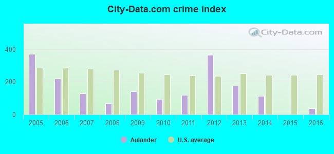
Crime rate in Aulander detailed stats: murders, rapes, robberies, assaults, burglaries, thefts, arson
Full-time law enforcement employees in 2007, including police officers: 1 (1 officers - 1 male; 0 female).
| Officers per 1,000 residents here: | 1.15 |
| North Carolina average: | 2.38 |
 Recent articles from our blog. Our writers, many of them Ph.D. graduates or candidates, create easy-to-read articles on a wide variety of topics.

 | where does the trash from Eastern Carolina cities end up? other US states or foreign countries? (4 replies) |
| Vonage Help Needed (1 reply) |
Latest news from Aulander, NC collected exclusively by city-data.com from local newspapers, TV, and radio stations
Ancestries: American (10.9%), Italian (3.2%), English (3.0%), Dutch (1.1%).
Current Local Time: EST time zone
Elevation: 85 feet
Land area: 1.48 square miles.
Population density: 492 people per square mile (low).
11 residents are foreign born
| This town: | 1.5% |
| North Carolina: | 8.3% |
Median real estate property taxes paid for housing units with mortgages in 2022: $1,553 (1.0%)
Median real estate property taxes paid for housing units with no mortgage in 2022: $206 (0.3%)
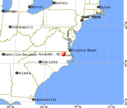
Nearest city with pop. 50,000+: Rocky Mount, NC  (43.2 miles , pop. 55,893).
Nearest city with pop. 200,000+: Norfolk, VA (65.6 miles , pop. 234,403).
Nearest city with pop. 1,000,000+: Philadelphia, PA (281.8 miles , pop. 1,517,550).
Nearest cities:
), ), ), ), ), Latitude: 36.23 N, Longitude: 77.11 W
Area code: 252


| Here: | 4.2% |
| North Carolina: | 3.2% |

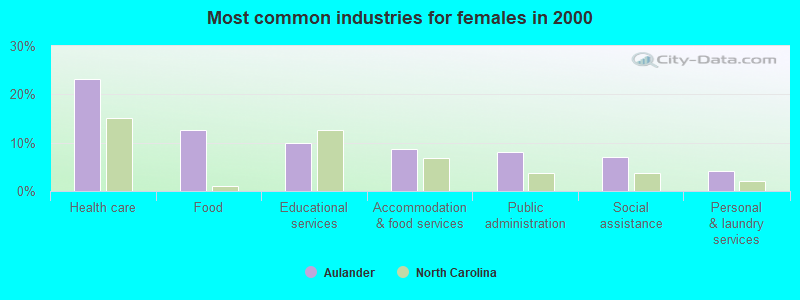
- Health care (13.2%)
- Food (9.7%)
- Metal & metal products (6.7%)
- Public administration (6.7%)
- Educational services (5.6%)
- Accommodation & food services (5.0%)
- Agriculture, forestry, fishing & hunting (3.5%)
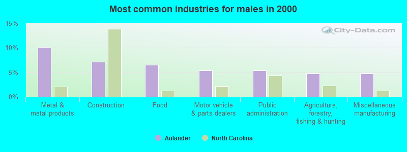
- Metal & metal products (10.1%)
- Construction (7.1%)
- Food (6.5%)
- Motor vehicle & parts dealers (5.4%)
- Public administration (5.4%)
- Agriculture, forestry, fishing & hunting (4.8%)
- Miscellaneous manufacturing (4.8%)
- Health care (23.1%)
- Food (12.7%)
- Educational services (9.8%)
- Accommodation & food services (8.7%)
- Public administration (8.1%)
- Social assistance (6.9%)
- Personal & laundry services (4.0%)
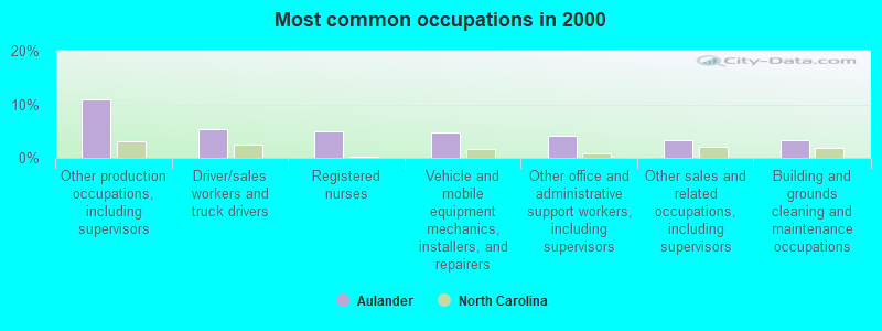
- Other production occupations, including supervisors (10.9%)
- Driver/sales workers and truck drivers (5.3%)
- Registered nurses (5.0%)
- Vehicle and mobile equipment mechanics, installers, and repairers (4.7%)
- Other office and administrative support workers, including supervisors (4.1%)
- Other sales and related occupations, including supervisors (3.2%)
- Building and grounds cleaning and maintenance occupations (3.2%)

- Other production occupations, including supervisors (10.1%)
- Vehicle and mobile equipment mechanics, installers, and repairers (9.5%)
- Driver/sales workers and truck drivers (9.5%)
- Carpenters (6.5%)
- Metal workers and plastic workers (6.5%)
- Material recording, scheduling, dispatching, and distributing workers (6.0%)
- Other sales and related occupations, including supervisors (5.4%)
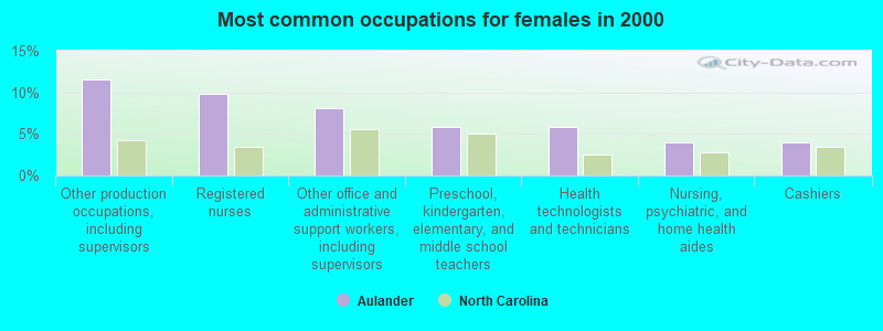
- Other production occupations, including supervisors (11.6%)
- Registered nurses (9.8%)
- Other office and administrative support workers, including supervisors (8.1%)
- Preschool, kindergarten, elementary, and middle school teachers (5.8%)
- Health technologists and technicians (5.8%)
- Nursing, psychiatric, and home health aides (4.0%)
- Cashiers (4.0%)
Average climate in Aulander, North Carolina
Based on data reported by over 4,000 weather stations


Tornado activity:
Aulander-area historical tornado activity is slightly above North Carolina state average. It is 1% greater than the overall U.S. average.
On 11/28/1988, a category F4 (max. wind speeds 207-260 mph) tornado 23.0 miles away from the Aulander town center killed 4 people and injured 154 people and caused between $50,000,000 and $500,000,000 in damages.
On 3/28/1984, a category F3 (max. wind speeds 158-206 mph) tornado 2.1 miles away from the town center killed 6 people and injured 19 people and caused between $500,000 and $5,000,000 in damages.
Earthquake activity:
Aulander-area historical earthquake activity is significantly above North Carolina state average. It is 59% smaller than the overall U.S. average.On 8/23/2011 at 17:51:04, a magnitude 5.8 (5.8 MW, Depth: 3.7 mi, Class: Moderate, Intensity: VI - VII) earthquake occurred 124.9 miles away from the city center
On 8/9/2020 at 12:07:37, a magnitude 5.1 (5.1 MW, Depth: 4.7 mi) earthquake occurred 222.5 miles away from Aulander center
On 12/9/2003 at 20:59:14, a magnitude 4.5 (4.5 MB, 4.5 LG, Class: Light, Intensity: IV - V) earthquake occurred 103.7 miles away from the city center
On 12/9/2003 at 20:59:18, a magnitude 4.5 (4.5 ML, Depth: 6.2 mi) earthquake occurred 120.0 miles away from the city center
On 8/25/2011 at 05:07:52, a magnitude 4.5 (4.5 ML, Depth: 4.2 mi) earthquake occurred 127.9 miles away from Aulander center
On 8/24/2011 at 00:04:36, a magnitude 4.2 (4.2 ML) earthquake occurred 125.6 miles away from the city center
Magnitude types: regional Lg-wave magnitude (LG), body-wave magnitude (MB), local magnitude (ML), moment magnitude (MW)
Natural disasters:
The number of natural disasters in Bertie County (20) is greater than the US average (15).Major Disasters (Presidential) Declared: 11
Emergencies Declared: 6
Causes of natural disasters: Hurricanes: 14, Storms: 3, Floods: 2, Tornadoes: 2, Blizzard: 1, Ice Storm: 1, Tropical Storm: 1, Wind: 1, Other: 1 (Note: some incidents may be assigned to more than one category).

Hospitals and medical centers near Aulander:
- HERTFORD-GATES HOME HEALTH AGENCY (Home Health Center, about 1 miles away; AHOSKIE, NC)
- VIDANT ROANOKE CHOWAN HOSPITAL Acute Care Hospitals (about 8 miles away; AHOSKIE, NC)
- UNIVERSITY HEALTH SYSTEMS HOME HEALTH AND HOSPICE (Hospital, about 8 miles away; AHOSKIE, NC)
- KINDRED TRANSITIONAL CARE AND REHAB-AHOSKIE (Nursing Home, about 8 miles away; AHOSKIE, NC)
- ROANOKE PLACE (Hospital, about 9 miles away; AHOSKIE, NC)
- RICH SQUARE HEALTH CARE CENTER (Nursing Home, about 11 miles away; RICH SQUARE, NC)
- ROANOKE VALLEY NH INC (Nursing Home, about 11 miles away; RICH SQUARE, NC)
Colleges/universities with over 2000 students nearest to Aulander:
- Edgecombe Community College (about 36 miles; Tarboro, NC; Full-time enrollment: 2,058)
- East Carolina University (about 46 miles; Greenville, NC; FT enrollment: 23,943)
- Nash Community College (about 48 miles; Rocky Mount, NC; FT enrollment: 2,520)
- Pitt Community College (about 50 miles; Winterville, NC; FT enrollment: 7,026)
- Elizabeth City State University (about 51 miles; Elizabeth City, NC; FT enrollment: 2,803)
- Southside Virginia Community College (about 62 miles; Alberta, VA; FT enrollment: 3,716)
- Tidewater Community College (about 63 miles; Norfolk, VA; FT enrollment: 20,975)
Public elementary/middle school in Aulander:
- AULANDER ELEMENTARY (Location: 2515 NC HIGHWAY 305 NORTH, Grades: PK-5)
Points of interest:
Notable location: Aulander Police Department (A). Display/hide its location on the map
Church in Aulander: Metropolitan Interdenominational Church of God (A). Display/hide its location on the map
Drinking water stations with addresses in Aulander and their reported violations in the past:
AULANDER, TOWN OF (Population served: 1,438, Groundwater):Past monitoring violations:
- Failure Submit IDSE/Subpart V Plan Rpt - In JUL-02-2010, Contaminant: DBP STAGE 2. Follow-up actions: St Compliance achieved (JAN-10-2011)
- Monitoring, Routine (IDSE) - In APR-02-2008, Contaminant: DBP STAGE 2. Follow-up actions: St Compliance achieved (JUN-30-2011)
- Monitoring and Reporting (DBP) - Between JAN-2005 and DEC-2005, Contaminant: Total Haloacetic Acids (HAA5). Follow-up actions: St Public Notif requested (JUN-20-2006), St Formal NOV issued (JUN-20-2006), St Public Notif received (JUL-10-2006), St Compliance achieved (DEC-28-2006)
- Monitoring and Reporting (DBP) - Between JAN-2005 and DEC-2005, Contaminant: TTHM. Follow-up actions: St Public Notif requested (JUN-20-2006), St Formal NOV issued (JUN-20-2006), St Public Notif received (JUL-10-2006), St Compliance achieved (DEC-28-2006)
| This town: | 2.4 people |
| North Carolina: | 2.5 people |
| This town: | 59.8% |
| Whole state: | 66.7% |
| This town: | 6.9% |
| Whole state: | 5.9% |
Likely homosexual households (counted as self-reported same-sex unmarried-partner households)
- Lesbian couples: 0.0% of all households
- Gay men: 0.8% of all households
5 people in workers' group living quarters and job corps centers in 2010
Banks with branches in Aulander (2011 data):
- Southern Bank and Trust Company: Aulander Branch at 119 South Commerce Street, branch established on 1935/05/06. Info updated 2011/09/26: Bank assets: $2,039.8 mil, Deposits: $1,658.5 mil, headquarters in Mount Olive, NC, positive income, Commercial Lending Specialization, 66 total offices, Holding Company: Southern Bancshares (N.C.), Inc.
For population 15 years and over in Aulander:
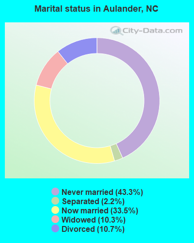
- Never married: 43.3%
- Now married: 33.5%
- Separated: 2.2%
- Widowed: 10.3%
- Divorced: 10.7%
For population 25 years and over in Aulander:
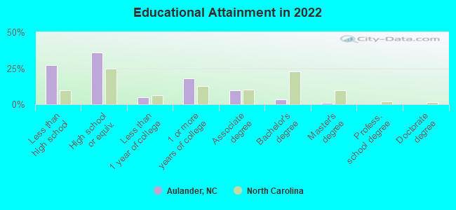
- High school or higher: 71.5%
- Bachelor's degree or higher: 4.2%
- Graduate or professional degree: 1.0%
- Unemployed: 3.7%
- Mean travel time to work (commute): 26.2 minutes
| Here: | 9.2 |
| North Carolina average: | 11.7 |
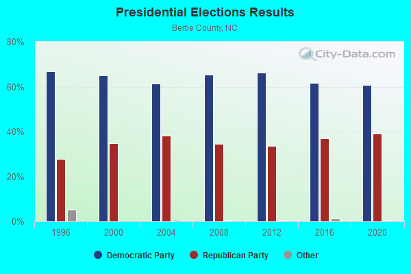
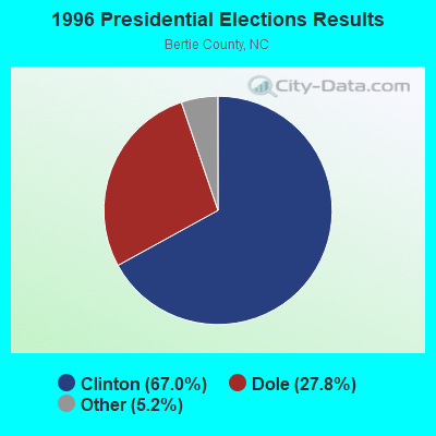
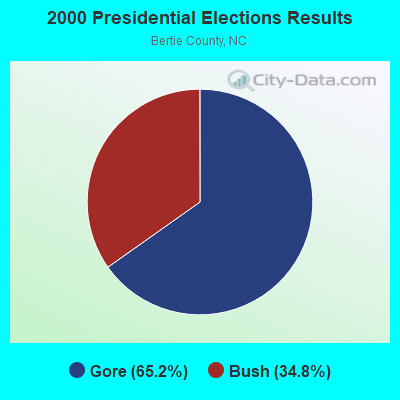
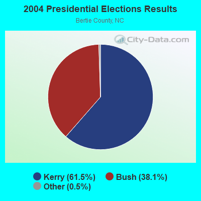
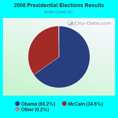
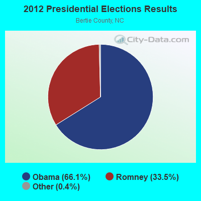
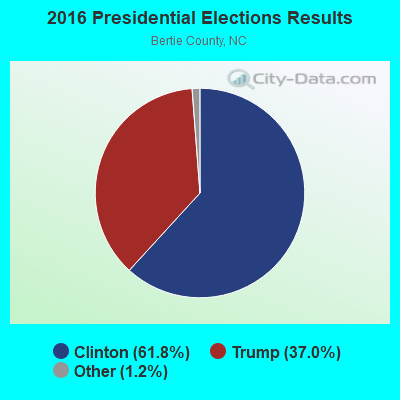
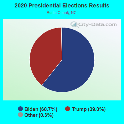
Graphs represent county-level data. Detailed 2008 Election Results
Religion statistics for Aulander, NC (based on Bertie County data)
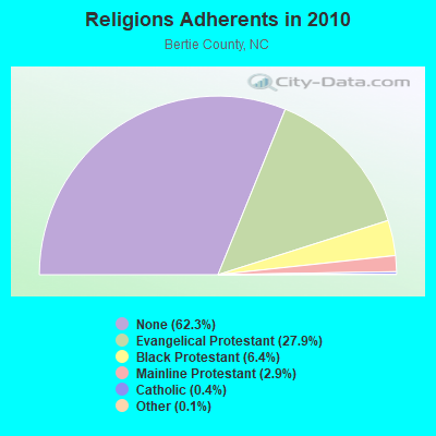
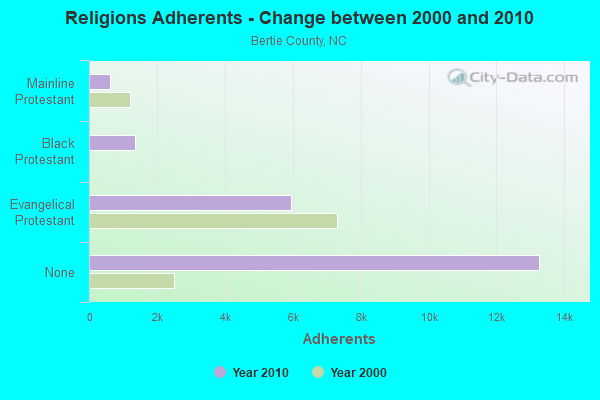
| Religion | Adherents | Congregations |
|---|---|---|
| Evangelical Protestant | 5,940 | 32 |
| Black Protestant | 1,360 | 9 |
| Mainline Protestant | 615 | 9 |
| Catholic | 76 | 1 |
| Other | 24 | 1 |
| None | 13,267 | - |
Food Environment Statistics:
| Bertie County: | 4.63 / 10,000 pop. |
| North Carolina: | 2.05 / 10,000 pop. |
| Bertie County: | 5.66 / 10,000 pop. |
| State: | 4.75 / 10,000 pop. |
| Here: | 3.08 / 10,000 pop. |
| State: | 7.57 / 10,000 pop. |
| This county: | 14.0% |
| North Carolina: | 9.8% |
| Bertie County: | 37.0% |
| North Carolina: | 28.3% |
| This county: | 16.4% |
| State: | 15.6% |
Health and Nutrition:
| Aulander: | 48.9% |
| State: | 48.9% |
| Aulander: | 44.9% |
| State: | 46.1% |
| This city: | 30.1 |
| State: | 28.8 |
| Aulander: | 19.9% |
| North Carolina: | 20.7% |
| Aulander: | 14.8% |
| North Carolina: | 10.7% |
| Aulander: | 6.8 |
| North Carolina: | 6.8 |
| Aulander: | 38.0% |
| State: | 33.7% |
| Aulander: | 53.7% |
| North Carolina: | 55.8% |
| This city: | 77.4% |
| North Carolina: | 79.7% |
More about Health and Nutrition of Aulander, NC Residents
| Local government employment and payroll (March 2022) | |||||
| Function | Full-time employees | Monthly full-time payroll | Average yearly full-time wage | Part-time employees | Monthly part-time payroll |
|---|---|---|---|---|---|
| Sewerage | 2 | $7,856 | $47,136 | 0 | $0 |
| Solid Waste Management | 2 | $3,018 | $18,108 | 0 | $0 |
| Financial Administration | 1 | $5,040 | $60,480 | 1 | $1,639 |
| Other and Unallocable | 0 | $0 | 1 | $272 | |
| Police Protection - Officers | 0 | $0 | 3 | $4,243 | |
| Other Government Administration | 0 | $0 | 7 | $11,294 | |
| Totals for Government | 5 | $15,914 | $38,194 | 12 | $17,448 |
Aulander government finances - Expenditure in 2017 (per resident):
- Current Operations - Financial Administration: $252,000 ($346.63)
Regular Highways: $205,000 ($281.98)
Police Protection: $149,000 ($204.95)
Sewerage: $136,000 ($187.07)
Water Utilities: $125,000 ($171.94)
Miscellaneous Commercial Activities - Other: $58,000 ($79.78)
Parks and Recreation: $44,000 ($60.52)
- General - Interest on Debt: $8,000 ($11.00)
- Water Utilities - Interest on Debt: $15,000 ($20.63)
Aulander government finances - Revenue in 2017 (per resident):
- Charges - Sewerage: $230,000 ($316.37)
Miscellaneous Commercial Activities: $96,000 ($132.05)
Solid Waste Management: $1,000 ($1.38)
- Miscellaneous - General Revenue - Other: $35,000 ($48.14)
Interest Earnings: $0 ($0.00)
- Revenue - Water Utilities: $208,000 ($286.11)
- State Intergovernmental - Other: $108,000 ($148.56)
General Local Government Support: $74,000 ($101.79)
Highways: $28,000 ($38.51)
- Tax - Property: $278,000 ($382.39)
General Sales and Gross Receipts: $170,000 ($233.84)
Aulander government finances - Debt in 2017 (per resident):
- Long Term Debt - Beginning Outstanding - Unspecified Public Purpose: $570,000 ($784.04)
Outstanding Unspecified Public Purpose: $506,000 ($696.01)
Retired Unspecified Public Purpose: $63,000 ($86.66)
Strongest AM radio stations in Aulander:
- WTAR (850 AM; 50 kW; NORFOLK, VA; Owner: SINCLAIR COMMUNICATIONS)
- WCKO (1110 AM; daytime; 50 kW; NORFOLK, VA; Owner: WORD BROADCASTING NETWORK, INC.)
- WYAL (1280 AM; daytime; 5 kW; SCOTLAND NECK, NC)
- WPTF (680 AM; 50 kW; RALEIGH, NC; Owner: FIRST STATE COMMUNICATIONS)
- WRVA (1140 AM; 50 kW; RICHMOND, VA; Owner: CLEAR CHANNEL BROADCASTING LICENSES, INC.)
- WRJR (670 AM; 20 kW; CLAREMONT, VA; Owner: CHESAPEAKE-PORTSMOUTH BROADCASTING CORPORATION)
- WFTK (1030 AM; daytime; 50 kW; WAKE FOREST, NC; Owner: POSITIVE RADIO GROUP, INC.)
- WNCT (1070 AM; 10 kW; GREENVILLE, NC; Owner: WNCT LICENSE LIMITED PARTNERSHIP)
- WWDR (1080 AM; daytime; 1 kW; MURFREESBORO, NC; Owner: FIRST MEDIA RADIO, LLC)
- WGH (1310 AM; 20 kW; NEWPORT NEWS, VA; Owner: CHESAPEAKE BAY BROADCASTING, LLC)
- WDZY (1290 AM; 25 kW; COLONIAL HEIGHTS, VA; Owner: ABC, INC.)
- WPMH (1010 AM; 10 kW; PORTSMOUTH, VA; Owner: ABC, INC.)
- WJPI (1470 AM; 5 kW; PLYMOUTH, NC; Owner: FREE TEMPLE MINISTRIES INC..)
Strongest FM radio stations in Aulander:
- WBKU (91.7 FM; AHSOKIE, NC; Owner: AMERICAN FAMILY ASSOCIATION)
- WBXB (100.1 FM; EDENTON, NC; Owner: EDENTON CHRISTIAN RADIO, INC.)
- WCBZ (103.7 FM; WILLIAMSTON, NC; Owner: ABG NORTH CAROLINA, LLC)
- WKJX (96.7 FM; ELIZABETH CITY, NC; Owner: EAST CAROLINA RADIO OF ELIZABETH CITY, INC.)
- WTRG (100.7 FM; ROCKY MOUNT, NC; Owner: CAPSTAR TX LIMITED PARTNERSHIP)
- WURB (97.7 FM; WINDSOR, NC; Owner: WILLIS BROADCASTING CORPORATION)
- WAFX (106.9 FM; SUFFOLK, VA; Owner: TIDEWATER COMMUNICATIONS, LLC)
- WKTC (95.5 FM; PINETOPS, NC; Owner: WEQQ, INC.)
- WDLZ (98.3 FM; MURFREESBORO, NC; Owner: FIRST MEDIA RADIO, LLC)
- WQDK (99.3 FM; AHOSKIE, NC; Owner: MAX MEDIA OF THE CAROLINAS LLC)
- WIAM-FM (98.9 FM; WINDSOR, NC; Owner: LIFELINE MINISTRIES, INC.)
- WZRU (88.5 FM; ROANOKE RAPIDS, NC; Owner: ROANOKE VALLEY COMMUNICATIONS, INC.)
TV broadcast stations around Aulander:
- WUND-TV (Channel 2; COLUMBIA, NC; Owner: UNIVERSITY OF NORTH CAROLINA)
- WITN-TV (Channel 7; WASHINGTON, NC; Owner: WITN LICENSEE CORP.)
- WFTB-LP (Channel 55; WILLIAMSTON, ETC., NC; Owner: FREE TEMPLE MINISTRIES, INC.)
- WUNP-TV (Channel 36; ROANOKE RAPIDS, NC; Owner: UNIVERSITY OF NORTH CAROLINA)
Aulander fatal accident list:
Nov 16, 1984 02:25 PM, Commerce, Vehicles: 1, Persons: 2, Fatalities: 1
- National Bridge Inventory (NBI) Statistics
- 5Number of bridges
- 23ft / 7.3mTotal length
- 9,740Total average daily traffic
- 742Total average daily truck traffic
- 19,480Total future (year 2040) average daily traffic
FCC Registered Antenna Towers:
27 (See the full list of FCC Registered Antenna Towers in Aulander)FCC Registered Private Land Mobile Towers:
1- Cr 1188 .4 Mi N Jct Cr 1188 & Nc 11 (Lat: 36.265722 Lon: -77.107750), Structure height: 141 m, Call Sign: KNHY461,
Assigned Frequencies: 861.187 MHz, 861.412 MHz, 863.187 MHz, 863.412 MHz, 864.412 MHz, 865.412 MHz, Grant Date: 08/08/2006, Expiration Date: 09/13/2016, Cancellation Date: 07/16/2014, Registrant: Sprint Nextel Corporation, 12502 Sunrise Valley Drive, M/S: Varesa0209, Reston, VA 20196, Phone: (703) 433-4000, Fax: (703) 433-4483
FCC Registered Broadcast Land Mobile Towers:
6- Nc 305 At Millenium Fire Dept 1 Mi S (Lat: 36.243222 Lon: -77.093028), Call Sign: KZV310, Licensee ID: L00005452,
Assigned Frequencies: 39.1800 MHz, Grant Date: 10/17/2001, Expiration Date: 10/28/2011, Cancellation Date: 06/10/2004, Registrant: County Of Hertford, Cty Courthouse, Winton, NC 27986, Phone: (919) 358-1621
- Rpr-1112 2 Mi N (Lat: 36.265722 Lon: -77.107750), Type: Tower, Structure height: 122 m, Call Sign: KNFS501,
Assigned Frequencies: 42.5000 MHz, 42.5200 MHz, 42.6000 MHz, 42.6200 MHz, 42.6400 MHz, 42.9200 MHz, Grant Date: 12/11/2004, Expiration Date: 03/08/2015, Cancellation Date: 12/01/2009, Registrant: North Carolina State Highway Patrol, 4702 Mail Service Center, Raleigh, NC 27699-4702, Phone: (919) 662-4440, Fax: (919) 662-4444, Email:
- Rpr 1112 2 Mi N (Lat: 36.265722 Lon: -77.107750), Structure height: 122 m, Call Sign: WPEN525, Licensee ID: L00018446,
Assigned Frequencies: 75.8200 MHz, Grant Date: 01/29/2004, Expiration Date: 03/29/2014, Cancellation Date: 12/01/2009, Registrant: State Of North Carolina, 1300 Blue Ridge Rd, Raleigh, NC 27607, Phone: (919) 792-4101
- Rpr 1112 2 Mi N (Lat: 36.265722 Lon: -77.107750), Call Sign: WSB26, Licensee ID: L00018446,
Assigned Frequencies: 72.6200 MHz, Grant Date: 07/18/2003, Expiration Date: 10/14/2013, Cancellation Date: 12/01/2009, Registrant: State Of North Carolina, 1300 Blue Ridge Rd, Raleigh, NC 27607
- Watertower 1.5 Mi Ssw Of Us 11 & Sr 305 (Lat: 36.214056 Lon: -77.108028), Call Sign: KNIC660,
Assigned Frequencies: 155.280 MHz, Grant Date: 10/26/2013, Expiration Date: 12/29/2023, Cancellation Date: 03/02/2024, Registrant: Bertie County Emergency Services, 106 Dundee St, Windsor, NC 27983, Phone: (252) 794-5302, Fax: (252) 794-5327, Email:
- Rt 350 2.7 Km Ne Int Rts 350 & 1112 Earleys Sub (Lat: 36.255444 Lon: -77.078306), Type: Tower, Structure height: 111 m, Overall height: 120 m, Call Sign: WRL415,
Assigned Frequencies: 48.0400 MHz, 48.2800 MHz, Grant Date: 05/07/2021, Expiration Date: 06/18/2031, Certifier: M J Jesensky, Registrant: Virginia Electric & Power Company, 600 East Canal St, Richmond, VA 23219, Phone: (804) 389-9738, Fax: (804) 771-6570, Email:
FCC Registered Microwave Towers:
2- AULANDER, 220 Brickmill Road (Lat: 36.240722 Lon: -77.084111), Type: Gtower, Structure height: 91.4 m, Overall height: 99.1 m, Call Sign: WRZJ862,
Assigned Frequencies: 11325.0 MHz, Grant Date: 11/09/2023, Expiration Date: 11/09/2033, Certifier: Douglas Chambers, Registrant: Wilkinson Barker Knauer, LLP, 1800 M Street Nw, Suite 800n, Washington, DC 20036, Phone: (202) 383-3420, Fax: (202) 783-5851, Email:
- EARLEYS, S Of Rt 350 1.7 Mi Ne Of Int Of Rt 350 & Secondary Rt 1112 (Lat: 36.255750 Lon: -77.078778), Type: Gtower, Structure height: 111.2 m, Overall height: 120.4 m, Call Sign: WED845,
Assigned Frequencies: 6855.00 MHz, 10775.0 MHz, 10815.0 MHz, 10775.0 MHz, 10815.0 MHz, 10775.0 MHz, 10815.0 MHz, 10775.0 MHz, 10815.0 MHz, 10775.0 MHz... (+100 more), Grant Date: 10/22/2020, Expiration Date: 11/15/2030, Registrant: Virginia Electric & Power Company, 600 East Canal St, Richmond, VA 23219, Phone: (804) 389-9738, Fax: (804) 771-6570, Email:
FCC Registered Maritime Coast & Aviation Ground Towers:
2- Tri County Airport (Lat: 36.299333 Lon: -77.175528), Type: Building, Overall height: 3 m, Call Sign: KJH7,
Assigned Frequencies: 122.800 MHz, Grant Date: 12/31/2014, Expiration Date: 12/01/2024, Registrant: Tri County Airport Authority, 140 Tri County Airport Rd, Aulander, NC 27805, Phone: (252) 345-0111, Email:
- Tri County Airport (Lat: 36.299167 Lon: -77.175556), Type: Tower, Call Sign: WRLB3030,
Assigned Frequencies: 0.41551 MHz, Grant Date: 11/25/2008, Expiration Date: 11/02/2018, Cancellation Date: 02/16/2019, Registrant: Tri-County Airport Authority, 140 Tri-County Airport Rd., Aulander, NC 27805, Phone: (252) 332-8279, Email:
FCC Registered Amateur Radio Licenses:
11 (See the full list of FCC Registered Amateur Radio Licenses in Aulander)FAA Registered Aircraft:
5- Aircraft: PIPER PA-12 (Category: Land, Seats: 3, Weight: Up to 12,499 Pounds, Speed: 82 mph), Engine: LYCOMING 0-290 SERIES (140 HP) (Reciprocating)
N-Number: 2491M, N2491M, N-2491M, Serial Number: 12-1698, Year manufactured: 1947, Airworthiness Date: 10/07/1955, Certificate Issue Date: 08/20/2001
Registrant (Corporation): Tri Air Inc, 140 Tri County Airport Rd, Aulander, NC 27805 - Aircraft: CESSNA 172N (Category: Land, Seats: 4, Weight: Up to 12,499 Pounds, Speed: 105 mph), Engine: LYCOMING 0-320 SERIES (180 HP) (Reciprocating)
N-Number: 734VZ, N734VZ, N-734VZ, Serial Number: 17269161, Year manufactured: 1977, Airworthiness Date: 05/23/1977, Certificate Issue Date: 11/19/2002
Registrant (Corporation): Tri Air Inc, 140 Tri County Airport Rd, Aulander, NC 27805 - Aircraft: CESSNA 172A (Category: Land, Seats: 4, Weight: Up to 12,499 Pounds, Speed: 105 mph), Engine: CONT MOTOR 0-300 SER (145 HP) (Reciprocating)
N-Number: 7561T, N7561T, N-7561T, Serial Number: 47161, Year manufactured: 1959, Certificate Issue Date: 07/01/1992
Registrant (Individual): Ruby S Cox, 139 Hollowell Rd, Aulander, NC 27805 - Aircraft: CESSNA 182Q (Category: Land, Seats: 4, Weight: Up to 12,499 Pounds, Speed: 112 mph), Engine: CONT MOTOR O-470 SERIES (230 HP) (Reciprocating)
N-Number: 94537, N94537, N-94537, Serial Number: 18266435, Year manufactured: 1978, Airworthiness Date: 05/16/1978, Certificate Issue Date: 03/28/2019
Registrant (Co-Owned): Russell L Joyner, 114 Mallard Ln, Aulander, NC 27805, Other Owners: Anelle T Joyner - Aircraft: TAYLORCRAFT BC12-D (Category: Land, Seats: 2, Weight: Up to 12,499 Pounds, Speed: 78 mph), Engine: CONT MOTOR A&C65 SERIES (65 HP) (Reciprocating)
N-Number: 96497, N96497, N-96497, Serial Number: 8797, Year manufactured: 1946, Airworthiness Date: 12/18/1956, Certificate Issue Date: 11/19/2002
Registrant (Corporation): Tri City Inc, 140 Tri County Airport Rd, Aulander, NC 27805
2004 - 2018 National Fire Incident Reporting System (NFIRS) incidents
- Fire incident types reported to NFIRS in Aulander, NC
- 7236.0%Structure Fires
- 6432.0%Outside Fires
- 5427.0%Mobile Property/Vehicle Fires
- 105.0%Other
 According to the data from the years 2004 - 2018 the average number of fire incidents per year is 13. The highest number of reported fire incidents - 32 took place in 2015, and the least - 2 in 2004. The data has a rising trend.
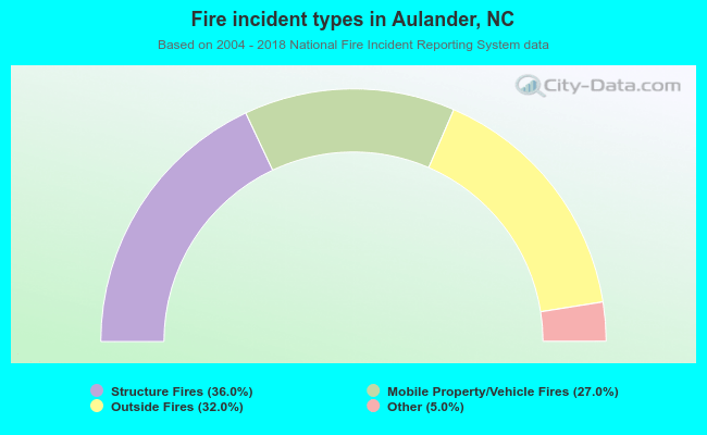 When looking into fire subcategories, the most incidents belonged to: Structure Fires (36.0%), and Outside Fires (32.0%).
| Most common first names in Aulander, NC among deceased individuals | ||
| Name | Count | Lived (average) |
|---|---|---|
| James | 54 | 69.5 years |
| William | 42 | 72.4 years |
| John | 34 | 74.8 years |
| Mary | 29 | 70.9 years |
| Willie | 26 | 74.0 years |
| Joseph | 25 | 67.7 years |
| Robert | 16 | 73.6 years |
| George | 16 | 69.2 years |
| Henry | 14 | 74.0 years |
| Annie | 14 | 79.8 years |
| Most common last names in Aulander, NC among deceased individuals | ||
| Last name | Count | Lived (average) |
|---|---|---|
| Lassiter | 52 | 74.9 years |
| Jenkins | 30 | 78.5 years |
| White | 29 | 65.6 years |
| Rawls | 29 | 73.6 years |
| Parker | 25 | 77.9 years |
| Outlaw | 24 | 74.9 years |
| Holloman | 21 | 76.8 years |
| Jones | 21 | 68.6 years |
| Cooke | 21 | 74.4 years |
| Cherry | 21 | 67.4 years |
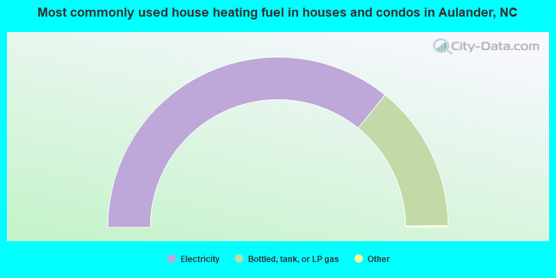
- 71.9%Electricity
- 28.1%Bottled, tank, or LP gas
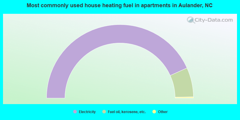
- 87.0%Electricity
- 13.0%Fuel oil, kerosene, etc.
Aulander compared to North Carolina state average:
- Median household income below state average.
- Median house value significantly below state average.
- Unemployed percentage significantly below state average.
- Black race population percentage above state average.
- Hispanic race population percentage significantly below state average.
- Foreign-born population percentage significantly below state average.
- Length of stay since moving in significantly above state average.
- House age above state average.
- Percentage of population with a bachelor's degree or higher significantly below state average.