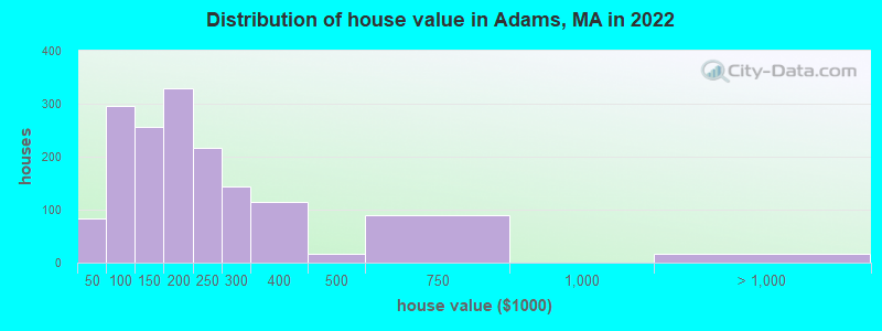
Estimated median house or condo value in 2022: $195,957 (it was $92,500 in 2000)
Adams:
$195,957
MA:
$534,700
Mean prices in 2022:all housing units: $357,971; detached houses: $376,086; townhouses or other attached units: $341,816; in 2-unit structures: $250,940; in 3-to-4-unit structures: $400,871; in 5-or-more-unit structures: $281,990; mobile homes: $80,872
Median gross rent in 2022: $848.
March 2022 cost of living index in Adams: 104.8 (near average, U.S. average is 100)
Percentage of residents living in poverty in 2022: 16.6%
(14.9% for White Non-Hispanic residents, 94.4% for Black residents, 51.6% for Hispanic or Latino residents, 100.0% for American Indian residents, 54.5% for two or more races residents)
The City-Data.com crime index weighs serious crimes and violent crimes more heavily. Higher means more crime, U.S. average is 246.1. It adjusts for the number of visitors and daily workers commuting into cities.
Latest news from Adams, MA collected exclusively by city-data.com from local newspapers, TV, and radio stations
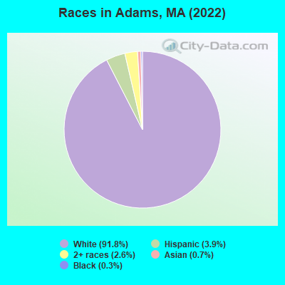
Ancestries: Polish (23.7%), French (16.8%), American (8.8%), Italian (8.2%), French Canadian (4.8%), English (4.3%).
Current Local Time: EST time zone
Incorporated in 1778
Elevation: 799 feet
Land area: 2.26 square miles.
Population density: 2,436 people per square mile (low).
126 residents are foreign born (0.9% Europe, 0.9% Asia, 0.3% Latin America).
This place:
2.2%
Massachusetts:
17.6%
Median real estate property taxes paid for housing units with mortgages in 2022: $3,349 (1.7%) Median real estate property taxes paid for housing units with no mortgage in 2022: $3,194 (1.6%)
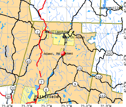
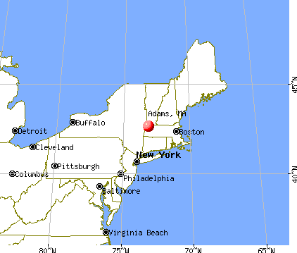
Nearest city with pop. 50,000+: Albany, NY (33.8 miles , pop. 95,658).
Nearest city with pop. 200,000+: Boston, MA (105.6 miles , pop. 589,141).
Nearest city with pop. 1,000,000+: Bronx, NY (129.0 miles , pop. 1,332,650).
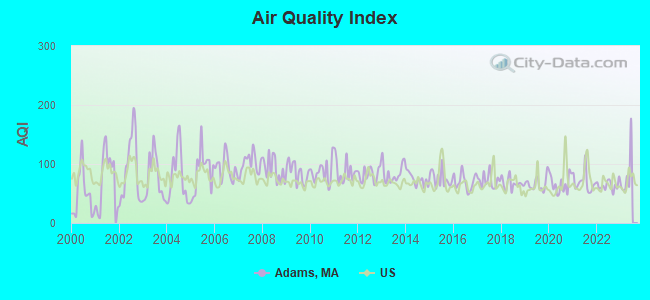
Air Quality Index (AQI) level in 2022 was 63.9. This is about average.
City:
63.9
U.S.:
72.6
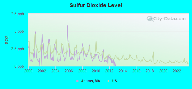
Sulfur Dioxide (SO2) [ppb] level in 2012 was 0.789. This is significantly better than average.Closest monitor was 4.6 miles away from the city center.
City:
0.789
U.S.:
1.515
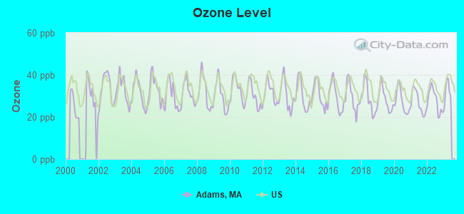
Ozone [ppb] level in 2022 was 28.0. This is about average.Closest monitor was 12.3 miles away from the city center.
City:
28.0
U.S.:
33.3
Particulate Matter (PM2.5) [µg/m3] level in 2022 was 5.97. This is better than average.Closest monitor was 5.3 miles away from the city center.
City:
5.97
U.S.:
8.11
Tornado activity:
Adams-area historical tornado activity is slightly above Massachusetts state average. It is 24% smaller than the overall U.S. average.
On 8/28/1973, a category F4 (max. wind speeds 207-260 mph) tornado 20.9 miles away from the Adams place center killed 4 peopleand injured 36 peopleand causedbetween $5,000,000 and $50,000,000 in damages.
On 5/29/1995, a category F4 tornado 31.6 miles away from the place center killed 3 peopleand injured 24 peopleand causedbetween $5,000,000 and $50,000,000 in damages.
Earthquake activity:
Adams-area historical earthquake activity is significantly above Massachusetts state average. It is 69% smaller than the overall U.S. average.
On 10/7/1983 at 10:18:46, a magnitude 5.3 (5.1 MB, 5.3 LG, 5.1 ML, Class: Moderate, Intensity: VI - VII) earthquake occurred 110.6 miles away from the city center On 4/20/2002 at 10:50:47, a magnitude 5.3 (5.3 ML, Depth: 3.0 mi) earthquake occurred 133.7 miles away from Adams center On 4/20/2002 at 10:50:47, a magnitude 5.2 (5.2 MB, 4.2 MS, 5.2 MW, 5.0 MW) earthquake occurred 132.2 miles away from the city center On 1/19/1982 at 00:14:42, a magnitude 4.7 (4.5 MB, 4.7 MD, 4.5 LG, Class: Light, Intensity: IV - V) earthquake occurred 97.7 miles away from the city center On 10/16/2012 at 23:12:25, a magnitude 4.7 (4.7 ML, Depth: 10.0 mi) earthquake occurred 141.3 miles away from Adams center On 6/17/1991 at 08:53:16, a magnitude 4.1 (4.0 MB, 4.0 LG, Depth: 3.1 mi) earthquake occurred 79.4 miles away from the city center Magnitude types: regional Lg-wave magnitude (LG), body-wave magnitude (MB), duration magnitude (MD), local magnitude (ML), surface-wave magnitude (MS), moment magnitude (MW)
Natural disasters:
The number of natural disasters in Berkshire County (21) is greater than the US average (15). Major Disasters (Presidential) Declared: 10 Emergencies Declared: 10
Causes of natural disasters: Floods: 5, Snowstorms: 5, Storms: 5, Hurricanes: 4, Winter Storms: 4, Blizzards: 2, Snows: 2, Snowfall: 1, Tropical Storm: 1, Wind: 1, Other: 1 (Note: some incidents may be assigned to more than one category).
Hospitals and medical centers in Adams:
HOSPICE OF N BERKSHIRE INC (46 HOWLAND AVENUE)
NORTHERN BERKSHIRE COMPREHENSIVE CARE (46 HOWLAND AVENUE)
Other hospitals and medical centers near Adams:
ADAMS N H OF N ADAMS (Nursing Home, about 6 miles away; NORTH ADAMS, MA)
NORTH ADAMS REGIONAL HOSPITAL Acute Care Hospitals (about 6 miles away; NORTH ADAMS, MA)
NORTH ADAMS COMMONS NURSING AND REHABILITATION CENTE (Nursing Home, about 6 miles away; NORTH ADAMS, MA)
WILLIAMSTOWN COMMONS NURSING AND REHAB (Nursing Home, about 7 miles away; WILLIAMSTOWN, MA)
SWEET BROOK OF WILLIAMSTOWN REHABILITATION AND N CTR (Nursing Home, about 7 miles away; WILLIAMSTOWN, MA)
CRANEVILLE PLACE AT DALTON (Nursing Home, about 12 miles away; DALTON, MA)
MT GREYLOCK EXTENDED CARE FACILITY (Nursing Home, about 13 miles away; PITTSFIELD, MA)
Amtrak station near Adams:
14 miles: PITTSFIELD (DEPOT ST. BTW NORTH & CENTER STS.) . Services: enclosed waiting area, public payphones, free short-term parking, free long-term parking, taxi stand, intercity bus service, public transit connection.
Colleges/universities with over 2000 students nearest to Adams:
Williams College (about 8 miles; Williamstown, MA; Full-time enrollment: 2,141)
Hudson Valley Community College (about 30 miles; Troy, NY; FT enrollment: 9,346)
Rensselaer Polytechnic Institute (about 30 miles; Troy, NY; FT enrollment: 6,940)
The Sage Colleges (about 31 miles; Troy, NY; FT enrollment: 2,499)
Smith College (about 33 miles; Northampton, MA; FT enrollment: 3,549)
Siena College (about 33 miles; Loudonville, NY; FT enrollment: 3,153)
The College of Saint Rose (about 35 miles; Albany, NY; FT enrollment: 4,085)
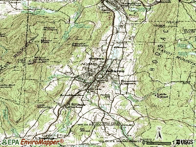
Notable locations in Adams: Forest Park Country Club (A), Susan B Anthony Homestead (B), Adams Forest Wardens (C), Adams Fire Department Station 1 Headquarters (D), Adams Ambulance Service (E), Adams Community Center (F), Adams Townhall (G). Display/hide their locations on the map
Churches in Adams include: First Baptist Church (A), Saint Thomas Aquinas Roman Catholic Church (B), Saint Stanislaus Kostka Roman Catholic Church (C), Saint Marks Episcopal Church (D), Quaker Meetinghouse (E), Old Quaker Meeting House (F), Notre Dame Church of Adams (G). Display/hide their locations on the map
Streams, rivers, and creeks: Miller Brook (A), Tophet Brook (B), Southwick Brook (C), Reed Brook (D), Pecks Brook (E), Hoxie Brook (F). Display/hide their locations on the map
Parks in Adams include: Renfrew Athletic Field (1), Rusek Whipple Square (2), Soldiers Memorial Field (3), Summer Street Historic District (4). Display/hide their locations on the map
Hotel: Dug-Out Motel (99 Howland Avenue).
Birthplace of: Susan B. Anthony - (1820-1906), feminist, Caleb Atwater - Politician, George N. Briggs - Politician, Edward S. Zelazo - Massachusetts politician, George P. Lawrence - Politician, Amy Lee (saxophonist) - Jazz saxophonist, Dave Murphy - Major League Baseball player, Harrison Potter - Classical pianist, Hiram Sibley - Philanthropist, John M. Darby - Botanist.
Berkshire County has a predicted average indoor radon screening level between 2 and 4 pCi/L (pico curies per liter) - Moderate Potential
Drinking water stations with addresses in Adams and their reported violations in the past:
ADAMS FIRE DISTRICT (Population served: 8,830, Groundwater):
Past health violations:
MCL, Monthly (TCR) - In JUL-2013, Contaminant: Coliform. Follow-up actions: St AO (w/o penalty) issued (JUL-19-2013)
MCL, Monthly (TCR) - In OCT-2012, Contaminant: Coliform. Follow-up actions: St AO (w/o penalty) issued (DEC-06-2012)
MCL, Monthly (TCR) - In AUG-2012, Contaminant: Coliform. Follow-up actions: St AO (w/o penalty) issued (2 times from SEP-21-2012 to DEC-06-2012), St Compliance achieved (JAN-11-2013)
Average household size:
This place:
2.1 people
Massachusetts:
2.5 people
Percentage of family households:
This place:
55.6%
Whole state:
63.0%
Percentage of households with unmarried partners:
This place:
8.3%
Whole state:
7.0%
Likely homosexual households (counted as self-reported same-sex unmarried-partner households)
Lesbian couples: 0.6% of all households
Gay men: 0.3% of all households
3 people in other noninstitutional facilities in 2010
2 people in religious group quarters in 2000
Banks with branches in Adams (2011 data):
Adams Community Bank: at 2 Center Street, branch established on 1869/05/01; Park Street Branch at 93 Park Street, branch established on 1895/01/01. Info updated 2012/03/02: Bank assets: $202.3 mil, Deposits: $163.5 mil, local headquarters, positive income, Mortgage Lending Specialization, 7 total offices
TD Bank, National Association: Adams Branch at 10 Center Street, branch established on 1962/08/01. Info updated 2010/10/04: Bank assets: $188,912.6 mil, Deposits: $153,149.8 mil, headquarters in Wilmington, DE, positive income, 1314 total offices, Holding Company: Toronto-Dominion Bank, The
Religion statistics for Adams, MA (based on Berkshire County data)
Religion
Adherents
Congregations
Catholic
50,187
32
Mainline Protestant
9,895
63
Other
3,647
20
Evangelical Protestant
2,817
28
Black Protestant
233
2
Orthodox
225
2
None
64,215
-
Source: Clifford Grammich, Kirk Hadaway, Richard Houseal, Dale E.Jones, Alexei Krindatch, Richie Stanley and Richard H.Taylor. 2012. 2010 U.S.Religion Census: Religious Congregations & Membership Study. Association of Statisticians of American Religious Bodies. Jones, Dale E., et al. 2002. Congregations and Membership in the United States 2000. Nashville, TN: Glenmary Research Center. Graphs represent county-level data
Aircraft: CHAMPION 7ECA (Category: Land, Seats: 2, Weight: Up to 12,499 Pounds, Speed: 90 mph), Engine: LYCOMING 0-235 SERIES (115 HP) (Reciprocating) N-Number: 145RW, N145RW, N-145RW, Serial Number: 800-71, Year manufactured: 1971, Airworthiness Date: 09/15/2000, Certificate Issue Date: 01/21/2014 Registrant (Individual): Richard Sawyer, 168 Orchard St, Adams, MA 01220
Aircraft: GULFSTREAM AMERICAN CORP AA-5B (Category: Land, Seats: 4, Weight: Up to 12,499 Pounds), Engine: Reciprocating N-Number: 22JT, N22JT, N-22JT, Serial Number: AA5B1198, Airworthiness Date: 06/12/1979, Certificate Issue Date: 05/19/2009 Registrant (Co-Owned): Joseph Trustee Thompson, C/O Joseph C Thompson Revocable T / 91 Orchard St, Adams, MA 01220, Other Owners: Jennifer Trustee Thompson
Aircraft: DRAKE PAUL F & STEVEN L BJ1-B DUSTER (Category: Land, Weight: Up to 12,499 Pounds), Engine: None N-Number: 80289, N80289, N-80289, Serial Number: 87, Year manufactured: 1979, Airworthiness Date: 09/24/1980, Certificate Issue Date: 01/08/2007 Registrant (Individual): Christopher J Belch, 32 Valley St, Adams, MA 01220
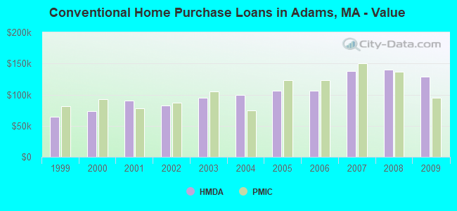
Home Mortgage Disclosure Act Aggregated Statistics For Year 2009 (Based on 1 full and 1 partial tracts)
A) FHA, FSA/RHS & VA Home Purchase Loans
B) Conventional Home Purchase Loans
C) Refinancings
D) Home Improvement Loans
E) Loans on Dwellings For 5+ Families
F) Non-occupant Loans on < 5 Family Dwellings (A B C & D)
Number
Average Value
Number
Average Value
Number
Average Value
Number
Average Value
Number
Average Value
Number
Average Value
LOANS ORIGINATED
6
$123,475
15
$128,863
42
$118,790
10
$62,002
2
$270,645
5
$181,688
APPLICATIONS APPROVED, NOT ACCEPTED
0
$0
1
$75,000
3
$131,723
0
$0
1
$464,000
1
$75,000
APPLICATIONS DENIED
1
$154,500
3
$87,483
21
$128,540
1
$128,540
1
$514,000
2
$84,500
APPLICATIONS WITHDRAWN
0
$0
9
$89,841
11
$116,549
4
$33,250
1
$125,000
0
$0
FILES CLOSED FOR INCOMPLETENESS
0
$0
1
$169,210
0
$0
0
$0
0
$0
0
$0
Aggregated Statistics For Year 2008 (Based on 1 full and 1 partial tracts)
A) FHA, FSA/RHS & VA Home Purchase Loans
B) Conventional Home Purchase Loans
C) Refinancings
D) Home Improvement Loans
E) Loans on Dwellings For 5+ Families
F) Non-occupant Loans on < 5 Family Dwellings (A B C & D)
Number
Average Value
Number
Average Value
Number
Average Value
Number
Average Value
Number
Average Value
Number
Average Value
LOANS ORIGINATED
3
$136,997
18
$140,322
40
$120,384
14
$48,910
1
$717,620
6
$128,682
APPLICATIONS APPROVED, NOT ACCEPTED
1
$122,410
1
$165,080
5
$86,168
1
$51,100
0
$0
0
$0
APPLICATIONS DENIED
0
$0
6
$121,418
16
$107,850
4
$54,618
0
$0
2
$115,315
APPLICATIONS WITHDRAWN
0
$0
3
$232,053
6
$148,032
0
$0
1
$525,000
0
$0
FILES CLOSED FOR INCOMPLETENESS
0
$0
1
$124,600
1
$289,610
0
$0
1
$580,000
0
$0
Aggregated Statistics For Year 2007 (Based on 1 full and 1 partial tracts)
A) FHA, FSA/RHS & VA Home Purchase Loans
B) Conventional Home Purchase Loans
C) Refinancings
D) Home Improvement Loans
E) Loans on Dwellings For 5+ Families
F) Non-occupant Loans on < 5 Family Dwellings (A B C & D)
G) Loans On Manufactured Home Dwelling (A B C & D)
Number
Average Value
Number
Average Value
Number
Average Value
Number
Average Value
Number
Average Value
Number
Average Value
Number
Average Value
LOANS ORIGINATED
1
$101,840
42
$137,443
35
$100,526
13
$77,668
1
$510,000
12
$123,737
1
$61,010
APPLICATIONS APPROVED, NOT ACCEPTED
0
$0
3
$106,123
4
$102,682
1
$128,000
1
$121,440
1
$142,620
0
$0
APPLICATIONS DENIED
0
$0
5
$128,010
16
$111,189
11
$100,215
1
$468,000
3
$170,383
0
$0
APPLICATIONS WITHDRAWN
0
$0
5
$114,058
13
$102,522
0
$0
1
$439,000
4
$104,582
0
$0
FILES CLOSED FOR INCOMPLETENESS
0
$0
2
$136,000
4
$132,915
1
$191,000
0
$0
0
$0
0
$0
Aggregated Statistics For Year 2006 (Based on 1 full and 1 partial tracts)
A) FHA, FSA/RHS & VA Home Purchase Loans
B) Conventional Home Purchase Loans
C) Refinancings
D) Home Improvement Loans
E) Loans on Dwellings For 5+ Families
F) Non-occupant Loans on < 5 Family Dwellings (A B C & D)
Number
Average Value
Number
Average Value
Number
Average Value
Number
Average Value
Number
Average Value
Number
Average Value
LOANS ORIGINATED
0
$0
47
$105,703
38
$104,325
23
$77,647
2
$239,800
11
$75,018
APPLICATIONS APPROVED, NOT ACCEPTED
1
$84,000
7
$92,846
8
$99,185
0
$0
0
$0
1
$170,450
APPLICATIONS DENIED
0
$0
9
$91,297
35
$94,655
11
$47,794
2
$173,060
2
$98,735
APPLICATIONS WITHDRAWN
0
$0
7
$145,154
17
$122,275
2
$56,520
0
$0
3
$152,333
FILES CLOSED FOR INCOMPLETENESS
0
$0
1
$108,400
3
$154,223
0
$0
0
$0
0
$0
Aggregated Statistics For Year 2005 (Based on 1 full and 1 partial tracts)
A) FHA, FSA/RHS & VA Home Purchase Loans
B) Conventional Home Purchase Loans
C) Refinancings
D) Home Improvement Loans
E) Loans on Dwellings For 5+ Families
F) Non-occupant Loans on < 5 Family Dwellings (A B C & D)
G) Loans On Manufactured Home Dwelling (A B C & D)
Number
Average Value
Number
Average Value
Number
Average Value
Number
Average Value
Number
Average Value
Number
Average Value
Number
Average Value
LOANS ORIGINATED
2
$126,450
63
$106,709
51
$104,700
18
$60,273
0
$0
23
$102,227
0
$0
APPLICATIONS APPROVED, NOT ACCEPTED
0
$0
2
$126,585
8
$123,519
3
$48,770
0
$0
3
$88,873
0
$0
APPLICATIONS DENIED
1
$158,000
18
$74,612
44
$115,012
8
$62,929
0
$0
10
$91,273
1
$113,630
APPLICATIONS WITHDRAWN
0
$0
9
$77,329
35
$112,794
1
$49,430
1
$488,220
7
$70,253
0
$0
FILES CLOSED FOR INCOMPLETENESS
0
$0
2
$71,385
10
$138,670
0
$0
0
$0
3
$142,333
0
$0
Aggregated Statistics For Year 2004 (Based on 1 full and 1 partial tracts)
A) FHA, FSA/RHS & VA Home Purchase Loans
B) Conventional Home Purchase Loans
C) Refinancings
D) Home Improvement Loans
E) Loans on Dwellings For 5+ Families
F) Non-occupant Loans on < 5 Family Dwellings (A B C & D)
Number
Average Value
Number
Average Value
Number
Average Value
Number
Average Value
Number
Average Value
Number
Average Value
LOANS ORIGINATED
1
$93,540
37
$99,844
40
$84,237
15
$51,897
5
$174,600
16
$75,254
APPLICATIONS APPROVED, NOT ACCEPTED
0
$0
4
$159,122
9
$96,318
1
$58,610
0
$0
0
$0
APPLICATIONS DENIED
0
$0
7
$94,289
19
$110,201
3
$21,820
0
$0
4
$38,978
APPLICATIONS WITHDRAWN
0
$0
7
$88,429
30
$91,406
3
$95,537
0
$0
3
$84,333
FILES CLOSED FOR INCOMPLETENESS
0
$0
0
$0
7
$87,080
0
$0
0
$0
0
$0
Aggregated Statistics For Year 2003 (Based on 1 full and 1 partial tracts)
A) FHA, FSA/RHS & VA Home Purchase Loans
B) Conventional Home Purchase Loans
C) Refinancings
D) Home Improvement Loans
E) Loans on Dwellings For 5+ Families
F) Non-occupant Loans on < 5 Family Dwellings (A B C & D)
Number
Average Value
Number
Average Value
Number
Average Value
Number
Average Value
Number
Average Value
Number
Average Value
LOANS ORIGINATED
3
$117,210
37
$95,172
104
$93,856
11
$49,823
1
$1,300,000
12
$75,527
APPLICATIONS APPROVED, NOT ACCEPTED
0
$0
2
$314,095
8
$68,255
2
$29,410
0
$0
1
$64,640
APPLICATIONS DENIED
0
$0
1
$116,970
24
$90,617
3
$15,870
0
$0
2
$92,965
APPLICATIONS WITHDRAWN
0
$0
2
$157,620
27
$98,683
0
$0
0
$0
0
$0
FILES CLOSED FOR INCOMPLETENESS
0
$0
0
$0
1
$151,630
0
$0
0
$0
0
$0
Aggregated Statistics For Year 2002 (Based on 1 full and 1 partial tracts)
A) FHA, FSA/RHS & VA Home Purchase Loans
B) Conventional Home Purchase Loans
C) Refinancings
D) Home Improvement Loans
E) Loans on Dwellings For 5+ Families
F) Non-occupant Loans on < 5 Family Dwellings (A B C & D)
Number
Average Value
Number
Average Value
Number
Average Value
Number
Average Value
Number
Average Value
Number
Average Value
LOANS ORIGINATED
5
$105,154
21
$82,691
50
$97,906
5
$19,256
2
$84,775
5
$96,782
APPLICATIONS APPROVED, NOT ACCEPTED
0
$0
1
$107,560
3
$74,023
0
$0
0
$0
0
$0
APPLICATIONS DENIED
0
$0
2
$123,465
18
$84,914
0
$0
0
$0
3
$111,570
APPLICATIONS WITHDRAWN
0
$0
3
$95,293
14
$91,850
0
$0
0
$0
0
$0
FILES CLOSED FOR INCOMPLETENESS
0
$0
0
$0
4
$96,112
0
$0
0
$0
0
$0
Aggregated Statistics For Year 2001 (Based on 1 full and 1 partial tracts)
A) FHA, FSA/RHS & VA Home Purchase Loans
B) Conventional Home Purchase Loans
C) Refinancings
D) Home Improvement Loans
E) Loans on Dwellings For 5+ Families
F) Non-occupant Loans on < 5 Family Dwellings (A B C & D)
Number
Average Value
Number
Average Value
Number
Average Value
Number
Average Value
Number
Average Value
Number
Average Value
LOANS ORIGINATED
4
$78,840
22
$90,755
36
$79,137
14
$13,791
3
$44,753
5
$55,750
APPLICATIONS APPROVED, NOT ACCEPTED
0
$0
3
$69,440
6
$64,162
3
$14,250
0
$0
1
$85,730
APPLICATIONS DENIED
0
$0
1
$133,640
21
$65,965
2
$20,640
0
$0
1
$65,000
APPLICATIONS WITHDRAWN
0
$0
2
$79,130
13
$64,223
0
$0
0
$0
0
$0
FILES CLOSED FOR INCOMPLETENESS
0
$0
0
$0
1
$73,140
0
$0
0
$0
0
$0
Aggregated Statistics For Year 2000 (Based on 1 full and 1 partial tracts)
A) FHA, FSA/RHS & VA Home Purchase Loans
B) Conventional Home Purchase Loans
C) Refinancings
D) Home Improvement Loans
E) Loans on Dwellings For 5+ Families
F) Non-occupant Loans on < 5 Family Dwellings (A B C & D)
Number
Average Value
Number
Average Value
Number
Average Value
Number
Average Value
Number
Average Value
Number
Average Value
LOANS ORIGINATED
5
$91,482
33
$73,586
13
$65,128
7
$13,444
1
$250,000
9
$45,390
APPLICATIONS APPROVED, NOT ACCEPTED
1
$77,000
4
$76,750
5
$53,500
1
$20,000
0
$0
0
$0
APPLICATIONS DENIED
0
$0
8
$50,892
16
$61,019
8
$22,676
0
$0
3
$68,700
APPLICATIONS WITHDRAWN
0
$0
4
$55,250
13
$49,937
1
$3,000
0
$0
1
$28,000
FILES CLOSED FOR INCOMPLETENESS
0
$0
1
$120,000
2
$83,165
0
$0
0
$0
0
$0
Aggregated Statistics For Year 1999 (Based on 1 full and 1 partial tracts)
A) FHA, FSA/RHS & VA Home Purchase Loans
B) Conventional Home Purchase Loans
C) Refinancings
D) Home Improvement Loans
E) Loans on Dwellings For 5+ Families
F) Non-occupant Loans on < 5 Family Dwellings (A B C & D)
Detailed PMIC statistics for the following Tracts:9221.00
, 9222.00
2002 - 2018 National Fire Incident Reporting System (NFIRS) incidents
Based on the data from the years 2002 - 2018 the average number of fire incidents per year is 32. The highest number of reported fires - 47 took place in 2017, and the least - 6 in 2003. The data has an increasing trend.
When looking into fire subcategories, the most reports belonged to: Structure Fires (70.4%), and Outside Fires (18.0%).
Fire incident types reported to NFIRS in Adams, MA
#66 on the list of "Top 100 cities with oldest houses (pop. 5,000+)"
#72 on the list of "Top 101 cities with the highest number of rapes per 100,000 residents, excludes tourist destinations and others with a lot of outsiders visiting based on city industries data (population 5,000+)"
#83 (01220) on the list of "Top 101 zip codes with the largest percentage of Polish first ancestries (pop 5,000+)"
#14 on the list of "Top 101 counties with the lowest number of births per 1000 residents 2007-2013"
#22 on the list of "Top 101 counties with the lowest percentage of residents relocating from other counties between 2010 and 2011"
#28 on the list of "Top 101 counties with the lowest percentage of residents relocating to other counties in 2011"
#53 on the list of "Top 101 counties with highest percentage of residents voting for Obama (Democrat) in the 2012 Presidential Election"
#71 on the list of "Top 101 counties with the largest number of people moving out compared to moving in (pop. 50,000+)"


 Recent articles from our blog. Our writers, many of them Ph.D. graduates or candidates, create easy-to-read articles on a wide variety of topics.

 (33.8 miles


 Based on the data from the years 2002 - 2018 the average number of fire incidents per year is 32. The highest number of reported fires - 47 took place in 2017, and the least - 6 in 2003. The data has an increasing trend.
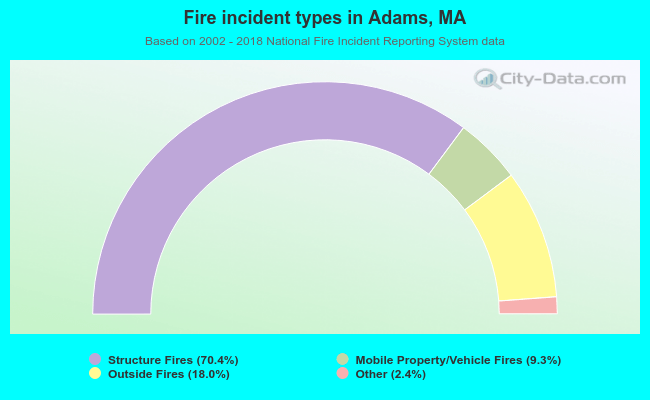 When looking into fire subcategories, the most reports belonged to: Structure Fires (70.4%), and Outside Fires (18.0%).