Bridge Statistics for Yulee, Florida (FL)
Condition, Traffic, Stress, Structural Evaluation, Project Costs
- National Bridge Inventory (NBI) Statistics
- 15Number of bridges
- 157ft / 47.9mTotal length
- $1,765,000Total costs
- 195,003Total average daily traffic
- 20,976Total average daily truck traffic
- National Bridge Inventory (NBI) Registered Bridges for Yulee
- No street view available for this location
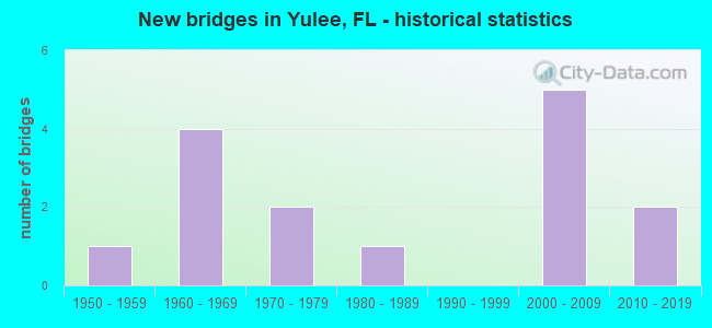
- New bridges - historical statistics
- 11950-1959
- 41960-1969
- 21970-1979
- 11980-1989
- 52000-2009
- 22010-2019


- Bridge Condition - Deck
- 22.2%Very good
- 66.7%Good
- 11.1%Satisfactory

- Bridge Condition - Superstructure
- 22.2%Very good
- 66.7%Good
- 11.1%Satisfactory

- Bridge Condition - Substructure
- 11.1%Very good
- 55.6%Good
- 22.2%Satisfactory
- 11.1%Poor

- Bridge Condition - Channel
- 63.6%Good
- 18.2%Satisfactory
- 9.1%Fair
- 9.1%Poor

- Bridge Condition - Culverts
- 25.0%Good
- 25.0%Satisfactory
- 25.0%Fair
- 25.0%Poor
Find on map >> Show street view
Structure Number: 740034, Location: I-95 SB OVER SR-A1A (Lat: 30.619444, Lng: -81.650000), Route carried "on" structure: Interstate 95, Year Built: 1967, Year Reconstructed: 1992, Status: Open, Structure Length: 4.69m (15.39ft), Average Daily Traffic: 27,000 (year 2020), Truck Traffic: 21%, Average Future Daily Traffic: 46,845 (year 2042), Design Load: HS 20+Mod, Features Intersected: SR-A1A & SR-200
Minimum Vertical Clearance: 30+ m (98+ ft), Kilometerpoint: 4.809, Lanes on structure: 3, Lanes under structure: 5, Base Highway Network: Yes, Owner: State Highway Agency, Approaching Roadway Width: 17.3m (56.8ft), Material/Design: Prestressed concrete, Design/Construction: Stringer/Multi-beam, Number Of Spans In Main Unit: 2, Length of Maximum Span: 23.5m (77.1ft), Curb-To-Curb Width: 17.0m (55.8ft), Out-to-Out Width: 17.8m (58.4ft)
Condition: Deck: Good, Superstructure: Good, Substructure: Good, Operating Rating: 34.9 metric tons, Method Used To Determine Operating Rating: Load and Resistance Factor (LRFR), Inventory Rating: 31.0 metric tons, Method Used To Determine Inventory Rating: Load and Resistance Factor (LRFR), Structural Evaluation: Better than present minimum criteria, Deck Geometry: Equal to present minimum criteria, Underclear: High priority of corrective action, Approach Roadway Alignment: Equal to present desirable criteria, Designated Inspection Frequency: Every 24 months, Inspection Date: July 2020, Deck Structure Type: Concrete Cast-file-Place
Find on map >> Show street view
Structure Number: 740069, Location: 2 MI EAST OF US 17 (Lat: 30.642972, Lng: -81.575139), Route carried "on" structure: County highway 200A, Year Built: 1958, Status: Temporarily open, Structure Length: 4.27m (14.01ft), Average Daily Traffic: 10,400 (year 2020), Truck Traffic: 4%, Average Future Daily Traffic: 18,044 (year 2042), Design Load: H 15, Features Intersected: LOFTON CREEK
Minimum Vertical Clearance: 30+ m (98+ ft), Kilometerpoint: 4.023, Lanes on structure: 2, Owner: County Highway Agency, Approaching Roadway Width: 9.4m (30.8ft), Material/Design: Concrete, Design/Construction: Slab, Number Of Spans In Main Unit: 7, Length of Maximum Span: 6.1m (20.0ft), Curb-To-Curb Width: 7.3m (24.0ft), Out-to-Out Width: 7.8m (25.6ft)
Condition: Deck: Satisfactory, Superstructure: Satisfactory, Substructure: Poor, Channel: Satisfactory, Structural Evaluation: High priority of corrective action, Deck Geometry: High priority of replacement, Waterway Adequacy: Equal to present desirable criteria, Approach Roadway Alignment: Better than present minimum criteria, Length Of Structure Improvement: 5.54m (18.18ft), Designated Inspection Frequency: Every 24 months, Underwater Inspection Frequency: Every 12 months, Other Special Inspection Frequency: Every 12 months, Inspection Date: June 2020, Underwater Inspection Date: June 2021, Other Special Inspection Date: June 2021, Bridge Improvement Cost: $1,176,000, Roadway Improvement Cost: $118,000, Total Project Cost: $1,765,000, Deck Structure Type: Concrete Cast-file-Place
Find on map >> Show street view
Structure Number: 740075, Location: I-95 NB OVER SR-A1A (Lat: 30.619444, Lng: -81.649722), Route carried "on" structure: Interstate 95, Year Built: 1967, Year Reconstructed: 1992, Status: Open, Structure Length: 4.69m (15.39ft), Average Daily Traffic: 27,000 (year 2020), Truck Traffic: 21%, Average Future Daily Traffic: 46,845 (year 2042), Design Load: HS 20+Mod, Features Intersected: SR-A1A & SR-200
Minimum Vertical Clearance: 30+ m (98+ ft), Kilometerpoint: 4.809, Lanes on structure: 3, Lanes under structure: 5, Base Highway Network: Yes, Owner: State Highway Agency, Approaching Roadway Width: 17.1m (56.1ft), Material/Design: Prestressed concrete, Design/Construction: Stringer/Multi-beam, Number Of Spans In Main Unit: 2, Length of Maximum Span: 23.5m (77.1ft), Curb-To-Curb Width: 16.9m (55.4ft), Out-to-Out Width: 17.8m (58.4ft)
Condition: Deck: Good, Superstructure: Good, Substructure: Good, Operating Rating: 34.9 metric tons, Method Used To Determine Operating Rating: Load and Resistance Factor (LRFR), Inventory Rating: 31.0 metric tons, Method Used To Determine Inventory Rating: Load and Resistance Factor (LRFR), Structural Evaluation: Better than present minimum criteria, Deck Geometry: Equal to present minimum criteria, Underclear: High priority of corrective action, Approach Roadway Alignment: Equal to present desirable criteria, Designated Inspection Frequency: Every 24 months, Inspection Date: July 2020, Deck Structure Type: Concrete Cast-file-Place
Find on map >> Show street view
Structure Number: 740129, Location: 0.65 MI. N. OF DUVAL CO. (Lat: 30.583883, Lng: -81.602142), Route carried "on" structure: US 17, Year Built: 2001, Status: Open, Structure Length: 7.26m (23.82ft), Average Daily Traffic: 17,800 (year 2020), Truck Traffic: 4%, Average Future Daily Traffic: 30,883 (year 2042), Design Load: HS 20+Mod, Features Intersected: CREWS CREEK
Minimum Vertical Clearance: 30+ m (98+ ft), Kilometerpoint: 1.036, Lanes on structure: 2, Base Highway Network: Yes, Owner: State Highway Agency, Approaching Roadway Width: 10.5m (34.4ft), Material/Design: Concrete, Design/Construction: Slab, Number Of Spans In Main Unit: 7, Length of Maximum Span: 10.6m (34.8ft), Curb-To-Curb Width: 13.2m (43.3ft), Out-to-Out Width: 14.2m (46.6ft)
Condition: Deck: Good, Superstructure: Good, Substructure: Satisfactory, Channel: Good, Operating Rating: 70.5 metric tons, Method Used To Determine Operating Rating: Load Factor (LF), Inventory Rating: 42.3 metric tons, Method Used To Determine Inventory Rating: Load Factor (LF), Structural Evaluation: Equal to present minimum criteria, Deck Geometry: Somewhat better than minimum adequacy, Waterway Adequacy: Equal to present desirable criteria, Approach Roadway Alignment: Equal to present desirable criteria, Designated Inspection Frequency: Every 24 months, Inspection Date: June 2020, Deck Structure Type: Concrete Cast-file-Place
Find on map >> Show street view
Structure Number: 74013, Location: 1.25 MI. N. OF DUVAL CO. (Lat: 30.592261, Lng: -81.599553), Route carried "on" structure: US 17, Year Built: 2001, Status: Open, Structure Length: 5.25m (17.22ft), Average Daily Traffic: 17,800 (year 2020), Truck Traffic: 4%, Average Future Daily Traffic: 30,883 (year 2042), Design Load: HS 20+Mod, Features Intersected: NASSAU CREEK
Minimum Vertical Clearance: 30+ m (98+ ft), Kilometerpoint: 2.008, Lanes on structure: 2, Base Highway Network: Yes, Owner: State Highway Agency, Approaching Roadway Width: 9.8m (32.2ft), Material/Design: Concrete, Design/Construction: Slab, Number Of Spans In Main Unit: 5, Length of Maximum Span: 10.7m (35.1ft), Curb-To-Curb Width: 13.2m (43.3ft), Out-to-Out Width: 14.2m (46.6ft)
Condition: Deck: Good, Superstructure: Good, Substructure: Satisfactory, Channel: Good, Operating Rating: 67.6 metric tons, Method Used To Determine Operating Rating: Load Factor (LF), Inventory Rating: 40.6 metric tons, Method Used To Determine Inventory Rating: Load Factor (LF), Structural Evaluation: Equal to present minimum criteria, Deck Geometry: Somewhat better than minimum adequacy, Waterway Adequacy: Equal to present desirable criteria, Approach Roadway Alignment: Equal to present desirable criteria, Designated Inspection Frequency: Every 24 months, Inspection Date: May 2020, Deck Structure Type: Concrete Cast-file-Place
Find on map >> Show street view
Structure Number: 740131, Location: 1.7 MI. N. OF SR-A1A (Lat: 30.648861, Lng: -81.621389), Route carried "on" structure: US 17, Year Built: 2001, Status: Open, Structure Length: 1.30m (4.27ft), Average Daily Traffic: 11,000 (year 2020), Truck Traffic: 7%, Average Future Daily Traffic: 19,085 (year 2042), Design Load: HS 20+Mod, Features Intersected: BRANCH OF LOFTON CREEK
Minimum Vertical Clearance: 30+ m (98+ ft), Kilometerpoint: 9.176, Lanes on structure: 2, Base Highway Network: Yes, Owner: State Highway Agency, Approaching Roadway Width: 10.8m (35.4ft), Material/Design: Concrete, Design/Construction: Culvert, Number Of Spans In Main Unit: 4, Length of Maximum Span: 3.1m (10.2ft)
Condition: Channel: Good, Culverts: Good, Inventory Rating: 53.9 metric tons, Method Used To Determine Inventory Rating: Load Factor (LF), Structural Evaluation: Better than present minimum criteria, Waterway Adequacy: Equal to present desirable criteria, Approach Roadway Alignment: Equal to present desirable criteria, Designated Inspection Frequency: Every 24 months, Inspection Date: June 2020
Find on map >> Show street view
Structure Number: 740132, Location: 2.9 MI. N. OF SR-A1A (Lat: 30.663031, Lng: -81.635011), Route carried "on" structure: US 17, Year Built: 2001, Status: Open, Structure Length: 3.93m (12.89ft), Average Daily Traffic: 11,000 (year 2020), Truck Traffic: 7%, Average Future Daily Traffic: 19,085 (year 2042), Design Load: HS 20+Mod, Features Intersected: LOFTON CREEK
Minimum Vertical Clearance: 30+ m (98+ ft), Kilometerpoint: 11.215, Lanes on structure: 2, Base Highway Network: Yes, Owner: State Highway Agency, Approaching Roadway Width: 9.8m (32.2ft), Skew: 2 degrees, Material/Design: Concrete, Design/Construction: Slab, Number Of Spans In Main Unit: 3, Length of Maximum Span: 13.2m (43.3ft), Curb-To-Curb Width: 13.2m (43.3ft), Out-to-Out Width: 14.2m (46.6ft)
Condition: Deck: Good, Superstructure: Good, Substructure: Good, Channel: Good, Operating Rating: 73.4 metric tons, Method Used To Determine Operating Rating: Load Factor (LF), Inventory Rating: 44.0 metric tons, Method Used To Determine Inventory Rating: Load Factor (LF), Structural Evaluation: Better than present minimum criteria, Deck Geometry: Somewhat better than minimum adequacy, Waterway Adequacy: Equal to present desirable criteria, Approach Roadway Alignment: Equal to present desirable criteria, Designated Inspection Frequency: Every 24 months, Inspection Date: May 2020, Deck Structure Type: Concrete Cast-file-Place
Find on map >> Show street view
Structure Number: 740133, Location: 4.9 MI. N. OF YULEE (Lat: 30.689094, Lng: -81.654733), Route carried "on" structure: US 17, Year Built: 2002, Status: Open, Structure Length: 3.76m (12.34ft), Average Daily Traffic: 4,000 (year 2020), Truck Traffic: 7%, Average Future Daily Traffic: 6,940 (year 2042), Design Load: HS 20+Mod, Features Intersected: MCQUEEN SWAMP
Minimum Vertical Clearance: 30+ m (98+ ft), Kilometerpoint: 14.666, Lanes on structure: 2, Base Highway Network: Yes, Owner: State Highway Agency, Approaching Roadway Width: 9.8m (32.2ft), Skew: 3 degrees, Material/Design: Concrete, Design/Construction: Slab, Number Of Spans In Main Unit: 3, Length of Maximum Span: 12.6m (41.3ft), Curb-To-Curb Width: 13.2m (43.3ft), Out-to-Out Width: 14.1m (46.3ft)
Condition: Deck: Good, Superstructure: Good, Substructure: Good, Channel: Good, Operating Rating: 71.2 metric tons, Method Used To Determine Operating Rating: Load Factor (LF), Inventory Rating: 42.7 metric tons, Method Used To Determine Inventory Rating: Load Factor (LF), Structural Evaluation: Better than present minimum criteria, Deck Geometry: Equal to present minimum criteria, Waterway Adequacy: Equal to present desirable criteria, Approach Roadway Alignment: Equal to present desirable criteria, Designated Inspection Frequency: Every 24 months, Inspection Date: June 2020, Deck Structure Type: Concrete Cast-file-Place
Find on map >> Show street view
Structure Number: 740138, Location: SR-200 / LOFTON CREEK (Lat: 30.629647, Lng: -81.570989), Route carried "on" structure: State highway 200, Year Built: 2019, Status: Open, Structure Length: 6.58m (21.59ft), Average Daily Traffic: 36,500 (year 2019), Truck Traffic: 7%, Average Future Daily Traffic: 63,327 (year 2041), Design Load: HL 93, Features Intersected: LOFTON CREEK
Minimum Vertical Clearance: 30+ m (98+ ft), Kilometerpoint: 2.884, Lanes on structure: 4, Base Highway Network: Yes, Owner: State Highway Agency, Approaching Roadway Width: 26.2m (86.0ft), Navigation Control: Yes ( Vertical Clearance: 3.0m (9.8ft), Horizontal Clearance: 21.9m (71.9ft)), Material/Design: Prestressed concrete, Design/Construction: Stringer/Multi-beam, Number Of Spans In Main Unit: 3, Length of Maximum Span: 21.9m (71.9ft), Curb or Sidewalk Widths: Left: 1.8m (5.9ft), Right: 1.8m (5.9ft), Curb-To-Curb Width: 16.3m (53.5ft), Out-to-Out Width: 39.5m (129.6ft)
Condition: Deck: Very good, Superstructure: Very good, Substructure: Very good, Channel: Good, Operating Rating: 47.0 metric tons, Method Used To Determine Operating Rating: Load and Resistance Factor (LRFR), Inventory Rating: 33.7 metric tons, Method Used To Determine Inventory Rating: Load and Resistance Factor (LRFR), Structural Evaluation: Equal to present desirable criteria, Deck Geometry: Meets minimum limits, Waterway Adequacy: Superior to present desirable criteria, Approach Roadway Alignment: Equal to present desirable criteria, Designated Inspection Frequency: Every 24 months, Underwater Inspection Frequency: Every 23 months, Inspection Date: March 2021, Underwater Inspection Date: March 2021, Deck Structure Type: Concrete Cast-file-Place
Find on map >> Show street view
Structure Number: 744303, Location: 0.4 MI NORTHEAST OF US 17 (Lat: 30.676500, Lng: -81.637500), Route carried "on" structure: County highway , Year Built: 1973, Status: Open, Structure Length: 3.31m (10.86ft), Average Daily Traffic: 51 (year 2020), Average Future Daily Traffic: 88 (year 2042), Features Intersected: SISTER CREEK, Facility Carried by Structure: CRANDALL ROAD
Minimum Vertical Clearance: 30+ m (98+ ft), Kilometerpoint: 2.923, Lanes on structure: 2, Owner: County Highway Agency, Approaching Roadway Width: 6.7m (22.0ft), Material/Design: Steel, Design/Construction: Culvert, Number Of Spans In Main Unit: 12, Length of Maximum Span: 2.1m (6.9ft)
Condition: Channel: Fair, Culverts: Fair, Structural Evaluation: Somewhat better than minimum adequacy, Waterway Adequacy: Equal to present desirable criteria, Approach Roadway Alignment: Equal to present desirable criteria, Designated Inspection Frequency: Every 24 months, Inspection Date: June 2020
Find on map >> Show street view
Structure Number: 744304, Location: 0.2 MI NORTHEAST OF US 17 (Lat: 30.674000, Lng: -81.639028), Route carried "on" structure: County highway , Year Built: 1973, Status: Open, Structure Length: 0.74m (2.43ft), Average Daily Traffic: 51 (year 2020), Average Future Daily Traffic: 88 (year 2042), Design Load: HS 20, Features Intersected: MCQUEEN SWAMP, Facility Carried by Structure: CRANDALL ROAD
Minimum Vertical Clearance: 30+ m (98+ ft), Kilometerpoint: 0.348, Lanes on structure: 2, Owner: County Highway Agency, Approaching Roadway Width: 8.2m (26.9ft), Material/Design: Steel, Design/Construction: Culvert, Number Of Spans In Main Unit: 3, Length of Maximum Span: 2.1m (6.9ft)
Condition: Channel: Poor, Culverts: Poor, Operating Rating: 52.9 metric tons, Method Used To Determine Operating Rating: Load Factor (LF), Inventory Rating: 31.6 metric tons, Method Used To Determine Inventory Rating: Load Factor (LF), Structural Evaluation: Meets minimum limits, Waterway Adequacy: Equal to present desirable criteria, Approach Roadway Alignment: Better than present minimum criteria, Designated Inspection Frequency: Every 24 months, Other Special Inspection Frequency: Every 12 months, Inspection Date: June 2020, Other Special Inspection Date: June 2021
Find on map >> Show street view
Structure Number: 744315, Location: 0.9 MI NORTH OF SR 200 (Lat: 30.634944, Lng: -81.529583), Route carried "on" structure: County highway 107, Year Built: 2014, Status: Open, Structure Length: 1.34m (4.40ft), Average Daily Traffic: 1,900 (year 2020), Truck Traffic: 4%, Average Future Daily Traffic: 3,297 (year 2042), Design Load: HL 93, Features Intersected: LANCEFORD CREEK
Minimum Vertical Clearance: 30.18m (99.02ft), Kilometerpoint: 1.518, Lanes on structure: 2, Owner: County Highway Agency, Approaching Roadway Width: 10.4m (34.1ft), Material/Design: Prestressed concrete, Design/Construction: Slab, Number Of Spans In Main Unit: 1, Length of Maximum Span: 13.4m (44.0ft), Curb-To-Curb Width: 10.4m (34.1ft), Out-to-Out Width: 11.3m (37.1ft)
Condition: Deck: Very good, Superstructure: Very good, Substructure: Good, Channel: Good, Operating Rating: 61.4 metric tons, Method Used To Determine Operating Rating: Load and Resistance Factor (LRFR), Inventory Rating: 42.8 metric tons, Method Used To Determine Inventory Rating: Load and Resistance Factor (LRFR), Structural Evaluation: Better than present minimum criteria, Deck Geometry: Equal to present minimum criteria, Waterway Adequacy: Superior to present desirable criteria, Approach Roadway Alignment: Equal to present desirable criteria, Designated Inspection Frequency: Every 24 months, Inspection Date: September 2020, Deck Structure Type: Concrete Cast-file-Place, Wearing Surface/Protective System: Wearing Surface: Bituminous
Find on map >> Show street view
Structure Number: 744318, Location: .5 Mi W of Chester Rd (Lat: 30.676119, Lng: -81.548569), Route carried "on" structure: County highway , Year Built: 1985, Status: Open, Structure Length: 0.73m (2.40ft), Average Daily Traffic: 101 (year 2021), Truck Traffic: 1%, Average Future Daily Traffic: 175 (year 2042), Features Intersected: CREEK, Facility Carried by Structure: ROSES BLUFF ROAD
Minimum Vertical Clearance: 30+ m (98+ ft), Kilometerpoint: 0.000, Lanes on structure: 2, Owner: County Highway Agency, Approaching Roadway Width: 12.5m (41.0ft), Material/Design: Steel, Design/Construction: Culvert, Number Of Spans In Main Unit: 1, Length of Maximum Span: 0.0m
Condition: Channel: Satisfactory, Culverts: Satisfactory, Inventory Rating: 61.1 metric tons, Method Used To Determine Inventory Rating: Load and Resistance Factor (LRFR), Structural Evaluation: Equal to present minimum criteria, Waterway Adequacy: Better than present minimum criteria, Approach Roadway Alignment: Equal to present desirable criteria, Designated Inspection Frequency: Every 24 months, Inspection Date: November 2021
Find on map >> Show street view
Structure Number: 740034, Location: I-95 SB OVER SR-A1A (Lat: 30.619444, Lng: -81.650000), Route carried "under" structure: State highway A1A, Year Built: 1967, Structure Length: 0. m, Average Daily Traffic: 15,200 (year 2020), Truck Traffic: 11%, Features Intersected: SR-A1A & SR-200, Facility Carried by Structure: I-95 SB (SR-9)
Minimum Vertical Clearance: 4.91m (16.11ft), Kilometerpoint: 44.239, Lanes on structure: 3, Lanes under structure: 5, Material/Design: Prestressed concrete, Design/Construction: Stringer/Multi-beam, Length of Maximum Span: 23.5m (77.1ft)
Find on map >> Show street view
Structure Number: 740075, Location: I-95 NB OVER SR-A1A (Lat: 30.619444, Lng: -81.649722), Route carried "under" structure: State highway A1A, Year Built: 1967, Structure Length: 0. m, Average Daily Traffic: 15,200 (year 2020), Truck Traffic: 11%, Features Intersected: SR-A1A & SR-200, Facility Carried by Structure: I-95 NB (SR-9)
Minimum Vertical Clearance: 5.32m (17.45ft), Kilometerpoint: 44.263, Lanes on structure: 3, Lanes under structure: 5, Material/Design: Prestressed concrete, Design/Construction: Stringer/Multi-beam, Length of Maximum Span: 23.5m (77.1ft)