Bridge Statistics for Wrentham, Massachusetts (MA)
Condition, Traffic, Stress, Structural Evaluation, Project Costs
- National Bridge Inventory (NBI) Statistics
- 13Number of bridges
- 102ft / 30.8mTotal length
- $29,940,000Total costs
- 384,071Total average daily traffic
- 14,603Total average daily truck traffic
- National Bridge Inventory (NBI) Registered Bridges for Wrentham
- No street view available for this location
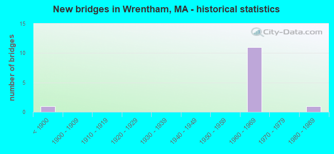
- New bridges - historical statistics
- 1Before 1900
- 111960-1969
- 11980-1989


- Bridge Condition - Deck
- 25.0%Good
- 75.0%Satisfactory

- Bridge Condition - Superstructure
- 25.0%Good
- 25.0%Satisfactory
- 50.0%Fair

- Bridge Condition - Substructure
- 37.5%Good
- 62.5%Satisfactory
Find on map >> Show street view
Structure Number: W460023P8DOTNBI, Location: 1 MI E OF FRANKLIN T.L. (Lat: 42.072869, Lng: -71.349064), Route carried "on" structure: State highway 140, Year Built: 1983, Status: Open, Structure Length: 0.82m (2.69ft), Average Daily Traffic: 17,800 (year 2018), Truck Traffic: 9%, Average Future Daily Traffic: 32,060 (year 2031), Design Load: HS 20, Features Intersected: WATER EAGLE BROOK
Minimum Vertical Clearance: 30+ m (98+ ft), Kilometerpoint: 71.775, Lanes on structure: 2, Base Highway Network: Yes, Owner: State Highway Agency, Approaching Roadway Width: 13.4m (44.0ft), Skew: 5 degrees, Material/Design: Concrete, Design/Construction: Culvert, Number Of Spans In Main Unit: 2, Length of Maximum Span: 4.0m (13.1ft), Curb or Sidewalk Widths: Left: 1.5m (4.9ft), Right: 1.5m (4.9ft), Curb-To-Curb Width: 13.4m (44.0ft), Out-to-Out Width: 17.4m (57.1ft)
Condition: Channel: Good, Culverts: Good, Operating Rating: 71.1 metric tons, Method Used To Determine Operating Rating: Load Factor (LF), Inventory Rating: 42.7 metric tons, Method Used To Determine Inventory Rating: Load Factor (LF), Structural Evaluation: Better than present minimum criteria, Deck Geometry: Equal to present minimum criteria, Waterway Adequacy: Equal to present desirable criteria, Approach Roadway Alignment: Equal to present desirable criteria, Length Of Structure Improvement: 2.20m (7.22ft), Designated Inspection Frequency: Every 24 months, Inspection Date: May 2020, Bridge Improvement Cost: $23,000, Roadway Improvement Cost: $3,000, Total Project Cost: $35,000 ( Estimate for 2022)
Find on map >> Show street view
Structure Number: W460043MADOTNBI, Location: .2 MI N OF RT140/EAST ST (Lat: 42.069775, Lng: -71.323992), Route carried "on" structure: Alternate State highway 1A, Year Built: 1890, Year Reconstructed: 1971, Status: Open, Structure Length: 3.96m (12.99ft), Average Daily Traffic: 11,500 (year 2021), Truck Traffic: 8%, Average Future Daily Traffic: 26,532 (year 2032), Design Load: H 20, Features Intersected: RR PCRR (ABANDONED), Facility Carried by Structure: ST 1 A/DEDHAM ST
Minimum Vertical Clearance: 30+ m (98+ ft), Kilometerpoint: 9.628, Lanes on structure: 2, Owner: State Highway Agency, Approaching Roadway Width: 13.7m (44.9ft), Skew: 3 degrees, Material/Design: Steel, Design/Construction: Stringer/Multi-beam, Number Of Spans In Main Unit: 1, Number Of Approach Spans: 2, Length of Maximum Span: 18.0m (59.1ft), Curb or Sidewalk Widths: Left: 1.5m (4.9ft), Right: 0.5m (1.6ft), Curb-To-Curb Width: 13.7m (44.9ft), Out-to-Out Width: 16.7m (54.8ft)
Condition: Deck: Satisfactory, Superstructure: Fair, Substructure: Satisfactory, Operating Rating: 38.3 metric tons, Method Used To Determine Operating Rating: Allowable Stress (AS), Inventory Rating: 22.6 metric tons, Method Used To Determine Inventory Rating: Allowable Stress (AS), Structural Evaluation: Somewhat better than minimum adequacy, Deck Geometry: Superior to present desirable criteria, Approach Roadway Alignment: Equal to present desirable criteria, Length Of Structure Improvement: 4.00m (13.12ft), Designated Inspection Frequency: Every 24 months, Inspection Date: August 2021, Bridge Improvement Cost: $2,624,000, Roadway Improvement Cost: $263,000, Total Project Cost: $3,937,000 ( Estimate for 2022), Deck Structure Type: Concrete Cast-file-Place, Wearing Surface/Protective System: Wearing Surface: Bituminous, Membrane: Built-up
Find on map >> Show street view
Structure Number: W460083VLDOTNBI, Location: .7 MI NW OF ST 1A (Lat: 42.043914, Lng: -71.357144), Route carried "on" structure: State highway 121, Year Built: 1966, Status: Open, Structure Length: 7.53m (24.70ft), Average Daily Traffic: 10,081 (year 2019), Truck Traffic: 5%, Average Future Daily Traffic: 16,267 (year 2031), Design Load: H 20, Features Intersected: I 495
Minimum Vertical Clearance: 30+ m (98+ ft), Kilometerpoint: 5.814, Lanes on structure: 2, Lanes under structure: 6, Owner: State Highway Agency, Approaching Roadway Width: 13.4m (44.0ft), Skew: 3 degrees, Material/Design: Steel, Design/Construction: Stringer/Multi-beam, Number Of Spans In Main Unit: 2, Length of Maximum Span: 37.2m (122.0ft), Curb or Sidewalk Widths: Left: 1.9m (6.2ft), Right: 0.5m (1.6ft), Curb-To-Curb Width: 13.4m (44.0ft), Out-to-Out Width: 19.2m (63.0ft)
Condition: Deck: Satisfactory, Superstructure: Fair, Substructure: Satisfactory, Operating Rating: 50.7 metric tons, Method Used To Determine Operating Rating: Allowable Stress (AS), Inventory Rating: 22.2 metric tons, Method Used To Determine Inventory Rating: Allowable Stress (AS), Structural Evaluation: Somewhat better than minimum adequacy, Deck Geometry: Equal to present minimum criteria, Underclear: High priority of corrective action, Approach Roadway Alignment: Equal to present desirable criteria, Length Of Structure Improvement: 7.60m (24.93ft), Designated Inspection Frequency: Every 24 months, Inspection Date: July 2020, Bridge Improvement Cost: $5,732,000, Roadway Improvement Cost: $574,000, Total Project Cost: $8,599,000 ( Estimate for 2022), Deck Structure Type: Concrete Cast-file-Place, Wearing Surface/Protective System: Wearing Surface: Bituminous, Membrane: Built-up
Find on map >> Show street view
Structure Number: W460093T0DOTNBI, Location: .2 MI W OF ST 1A (Lat: 42.040956, Lng: -71.348553), Route carried "on" structure: Interstate 495, Year Built: 1966, Status: Open, Structure Length: 2.80m (9.19ft), Average Daily Traffic: 45,438 (year 2019), Truck Traffic: 6%, Average Future Daily Traffic: 63,172 (year 2031), Design Load: HS 20+Mod, Features Intersected: RR PCRR (ABANDONED)
Minimum Vertical Clearance: 30+ m (98+ ft), Kilometerpoint: 60.928, Lanes on structure: 3, Base Highway Network: Yes, Owner: State Highway Agency, Approaching Roadway Width: 15.2m (49.9ft), Skew: 1 degrees, Material/Design: Steel, Design/Construction: Stringer/Multi-beam, Number Of Spans In Main Unit: 3, Length of Maximum Span: 9.4m (30.8ft), Curb-To-Curb Width: 15.2m (49.9ft), Out-to-Out Width: 16.6m (54.5ft)
Condition: Deck: Satisfactory, Superstructure: Satisfactory, Substructure: Good, Operating Rating: 50.1 metric tons, Method Used To Determine Operating Rating: Load Factor (LF), Inventory Rating: 30.0 metric tons, Method Used To Determine Inventory Rating: Load Factor (LF), Structural Evaluation: Equal to present minimum criteria, Deck Geometry: Meets minimum limits, Underclear: Meets minimum limits, Approach Roadway Alignment: Equal to present desirable criteria, Length Of Structure Improvement: 2.90m (9.51ft), Designated Inspection Frequency: Every 24 months, Inspection Date: June 2020, Bridge Improvement Cost: $1,891,000, Roadway Improvement Cost: $190,000, Total Project Cost: $2,837,000 ( Estimate for 2022), Deck Structure Type: Concrete Cast-file-Place, Wearing Surface/Protective System: Wearing Surface: Bituminous, Membrane: Built-up
Find on map >> Show street view
Structure Number: W460093T1DOTNBI, Location: .2 MI W OF ST 1A (Lat: 42.040567, Lng: -71.348628), Route carried "on" structure: Interstate 495, Year Built: 1966, Status: Open, Structure Length: 2.80m (9.19ft), Average Daily Traffic: 48,754 (year 2019), Truck Traffic: 5%, Average Future Daily Traffic: 71,068 (year 2031), Design Load: HS 20+Mod, Features Intersected: RR PCRR (ABANDONED)
Minimum Vertical Clearance: 30+ m (98+ ft), Kilometerpoint: 60.928, Lanes on structure: 4, Base Highway Network: Yes, Owner: State Highway Agency, Approaching Roadway Width: 15.8m (51.8ft), Skew: 1 degrees, Material/Design: Steel, Design/Construction: Stringer/Multi-beam, Number Of Spans In Main Unit: 3, Length of Maximum Span: 9.4m (30.8ft), Curb-To-Curb Width: 15.8m (51.8ft), Out-to-Out Width: 17.7m (58.1ft)
Condition: Deck: Satisfactory, Superstructure: Good, Substructure: Good, Operating Rating: 54.6 metric tons, Method Used To Determine Operating Rating: Load Factor (LF), Inventory Rating: 32.7 metric tons, Method Used To Determine Inventory Rating: Load Factor (LF), Structural Evaluation: Better than present minimum criteria, Deck Geometry: High priority of replacement, Underclear: High priority of corrective action, Approach Roadway Alignment: Equal to present desirable criteria, Length Of Structure Improvement: 2.90m (9.51ft), Designated Inspection Frequency: Every 24 months, Inspection Date: June 2020, Bridge Improvement Cost: $1,723,000, Roadway Improvement Cost: $173,000, Total Project Cost: $2,585,000 ( Estimate for 2022), Deck Structure Type: Concrete Cast-file-Place, Wearing Surface/Protective System: Wearing Surface: Bituminous, Membrane: Built-up
Find on map >> Show street view
Structure Number: W460103RXDOTNBI, Location: AT ST 1A (Lat: 42.040319, Lng: -71.345019), Route carried "on" structure: Interstate 495, Year Built: 1966, Status: Open, Structure Length: 2.80m (9.19ft), Average Daily Traffic: 49,214 (year 2021), Truck Traffic: 6%, Average Future Daily Traffic: 71,068 (year 2032), Design Load: HS 20+Mod, Features Intersected: ST 1 A/SOUTH ST
Minimum Vertical Clearance: 30+ m (98+ ft), Kilometerpoint: 60.510, Lanes on structure: 4, Lanes under structure: 4, Base Highway Network: Yes, Owner: State Highway Agency, Approaching Roadway Width: 15.8m (51.8ft), Skew: 2 degrees, Material/Design: Steel, Design/Construction: Stringer/Multi-beam, Number Of Spans In Main Unit: 1, Length of Maximum Span: 27.4m (89.9ft), Curb-To-Curb Width: 15.8m (51.8ft), Out-to-Out Width: 17.7m (58.1ft)
Condition: Deck: Good, Superstructure: Good, Substructure: Satisfactory, Operating Rating: 53.0 metric tons, Method Used To Determine Operating Rating: Load Factor (LF), Inventory Rating: 31.7 metric tons, Method Used To Determine Inventory Rating: Load Factor (LF), Structural Evaluation: Equal to present minimum criteria, Deck Geometry: High priority of replacement, Underclear: Meets minimum limits, Approach Roadway Alignment: Equal to present desirable criteria, Length Of Structure Improvement: 2.90m (9.51ft), Designated Inspection Frequency: Every 24 months, Inspection Date: November 2021, Bridge Improvement Cost: $2,017,000, Roadway Improvement Cost: $202,000, Total Project Cost: $3,026,000 ( Estimate for 2022), Deck Structure Type: Concrete Cast-file-Place, Wearing Surface/Protective System: Wearing Surface: Bituminous, Membrane: Built-up
Find on map >> Show street view
Structure Number: W460103RYDOTNBI, Location: AT ST 1A (Lat: 42.039922, Lng: -71.345214), Route carried "on" structure: Interstate 495, Year Built: 1966, Status: Open, Structure Length: 2.80m (9.19ft), Average Daily Traffic: 43,900 (year 2019), Truck Traffic: 6%, Average Future Daily Traffic: 71,068 (year 2032), Design Load: HS 20+Mod, Features Intersected: ST 1 A/SOUTH ST
Minimum Vertical Clearance: 30+ m (98+ ft), Kilometerpoint: 60.510, Lanes on structure: 4, Lanes under structure: 4, Base Highway Network: Yes, Owner: State Highway Agency, Approaching Roadway Width: 16.1m (52.8ft), Skew: 1 degrees, Material/Design: Steel, Design/Construction: Stringer/Multi-beam, Number Of Spans In Main Unit: 1, Length of Maximum Span: 26.3m (86.3ft), Curb-To-Curb Width: 16.1m (52.8ft), Out-to-Out Width: 17.1m (56.1ft)
Condition: Deck: Satisfactory, Superstructure: Satisfactory, Substructure: Good, Operating Rating: 54.6 metric tons, Method Used To Determine Operating Rating: Load Factor (LF), Inventory Rating: 32.7 metric tons, Method Used To Determine Inventory Rating: Load Factor (LF), Structural Evaluation: Equal to present minimum criteria, Deck Geometry: High priority of replacement, Underclear: Meets minimum limits, Approach Roadway Alignment: Equal to present minimum criteria, Length Of Structure Improvement: 2.80m (9.19ft), Designated Inspection Frequency: Every 24 months, Inspection Date: November 2021, Bridge Improvement Cost: $1,584,000, Roadway Improvement Cost: $159,000, Total Project Cost: $2,377,000 ( Estimate for 2022), Deck Structure Type: Concrete Cast-file-Place, Wearing Surface/Protective System: Wearing Surface: Bituminous, Membrane: Built-up
Find on map >> Show street view
Structure Number: W460113YJDOTNBI, Location: .8 MI. WEST OF U.S.1 (Lat: 42.037372, Lng: -71.320281), Route carried "on" structure: City street , Year Built: 1965, Status: Open, Structure Length: 3.66m (12.01ft), Average Daily Traffic: 8,292 (year 2017), Truck Traffic: 5%, Average Future Daily Traffic: 11,845 (year 2031), Design Load: H 20, Features Intersected: I 495 SB, Facility Carried by Structure: HWY TAUNTON ST
Minimum Vertical Clearance: 30+ m (98+ ft), Kilometerpoint: 0.000, Lanes on structure: 2, Lanes under structure: 3, Owner: State Highway Agency, Approaching Roadway Width: 12.2m (40.0ft), Skew: 2 degrees, Material/Design: Steel, Design/Construction: Stringer/Multi-beam, Number Of Spans In Main Unit: 1, Length of Maximum Span: 35.1m (115.2ft), Curb or Sidewalk Widths: Left: 0.6m (2.0ft), Right: 1.6m (5.2ft), Curb-To-Curb Width: 12.2m (40.0ft), Out-to-Out Width: 15.0m (49.2ft)
Condition: Deck: Good, Superstructure: Fair, Substructure: Satisfactory, Operating Rating: 53.5 metric tons, Method Used To Determine Operating Rating: Load Factor (LF), Inventory Rating: 32.1 metric tons, Method Used To Determine Inventory Rating: Load Factor (LF), Structural Evaluation: Somewhat better than minimum adequacy, Deck Geometry: Somewhat better than minimum adequacy, Underclear: High priority of corrective action, Approach Roadway Alignment: Equal to present desirable criteria, Length Of Structure Improvement: 3.70m (12.14ft), Designated Inspection Frequency: Every 24 months, Inspection Date: July 2020, Bridge Improvement Cost: $2,181,000, Roadway Improvement Cost: $219,000, Total Project Cost: $3,272,000 ( Estimate for 2022), Deck Structure Type: Concrete Cast-file-Place, Wearing Surface/Protective System: Wearing Surface: Bituminous, Membrane: Built-up
Find on map >> Show street view
Structure Number: W460113YKDOTNBI, Location: .8 MI W OF US 1 (Lat: 42.038192, Lng: -71.320914), Route carried "on" structure: City street , Year Built: 1965, Status: Open, Structure Length: 3.66m (12.01ft), Average Daily Traffic: 8,292 (year 2017), Truck Traffic: 5%, Average Future Daily Traffic: 11,845 (year 2031), Design Load: H 20, Features Intersected: I 495 NB, Facility Carried by Structure: HWY TAUNTON ST
Minimum Vertical Clearance: 30+ m (98+ ft), Kilometerpoint: 0.000, Lanes on structure: 2, Lanes under structure: 3, Owner: State Highway Agency, Approaching Roadway Width: 12.2m (40.0ft), Skew: 2 degrees, Material/Design: Steel, Design/Construction: Stringer/Multi-beam, Number Of Spans In Main Unit: 1, Length of Maximum Span: 35.1m (115.2ft), Curb or Sidewalk Widths: Left: 0.5m (1.6ft), Right: 1.6m (5.2ft), Curb-To-Curb Width: 12.2m (40.0ft), Out-to-Out Width: 15.0m (49.2ft)
Condition: Deck: Satisfactory, Superstructure: Fair, Substructure: Satisfactory, Operating Rating: 53.2 metric tons, Method Used To Determine Operating Rating: Load Factor (LF), Inventory Rating: 31.8 metric tons, Method Used To Determine Inventory Rating: Load Factor (LF), Structural Evaluation: Somewhat better than minimum adequacy, Deck Geometry: Somewhat better than minimum adequacy, Underclear: High priority of corrective action, Approach Roadway Alignment: Equal to present desirable criteria, Length Of Structure Improvement: 3.70m (12.14ft), Designated Inspection Frequency: Every 24 months, Inspection Date: July 2020, Bridge Improvement Cost: $2,181,000, Roadway Improvement Cost: $219,000, Total Project Cost: $3,272,000 ( Estimate for 2022), Deck Structure Type: Concrete Cast-file-Place, Wearing Surface/Protective System: Wearing Surface: Bituminous, Membrane: Built-up
Find on map >> Show street view
Structure Number: W460083VLDOTNBI, Location: .7 MI NW OF ST 1A (Lat: 42.050000, Lng: -71.350000), Route carried "under" structure: Interstate 495, Year Built: 1966, Structure Length: 0. m, Average Daily Traffic: 35,200 (year 0000), Features Intersected: I 495 SB, Facility Carried by Structure: ST121
Minimum Vertical Clearance: 5.13m (16.83ft), Kilometerpoint: 0.000, Lanes on structure: 4, Lanes under structure: 4, Material/Design: Steel, Design/Construction: Stringer/Multi-beam, Length of Maximum Span: 37.2m (122.0ft)
Find on map >> Show street view
Structure Number: W460083VLDOTNBI, Location: .7 MI NW OF ST 1A (Lat: 42.050000, Lng: -71.350000), Route carried "under" structure: Interstate 495, Year Built: 1966, Structure Length: 0. m, Average Daily Traffic: 35,200 (year 0000), Features Intersected: I 495 NB, Facility Carried by Structure: ST121
Minimum Vertical Clearance: 5.13m (16.83ft), Kilometerpoint: 0.000, Lanes on structure: 4, Lanes under structure: 4, Material/Design: Steel, Design/Construction: Stringer/Multi-beam, Length of Maximum Span: 37.2m (122.0ft)
Find on map >> Show street view
Structure Number: W460113YJDOTNBI, Location: 000065 STATUTORY (Lat: 42.033333, Lng: -71.316667), Route carried "under" structure: Interstate 495, Year Built: 1965, Structure Length: 0. m, Average Daily Traffic: 35,200 (year 0000), Features Intersected: I 495 SB, Facility Carried by Structure: HWY TAUNTON ST
Minimum Vertical Clearance: 5.08m (16.67ft), Kilometerpoint: 0.000, Lanes on structure: 4, Lanes under structure: 2, Material/Design: Steel, Design/Construction: Stringer/Multi-beam, Length of Maximum Span: 35.1m (115.2ft)
Find on map >> Show street view
Structure Number: W460113YKDOTNBI, Location: 000065 STATUTORY (Lat: 42.033333, Lng: -71.316667), Route carried "under" structure: Interstate 495, Year Built: 1965, Structure Length: 0. m, Average Daily Traffic: 35,200 (year 0000), Features Intersected: I 495 NB, Facility Carried by Structure: HWY TAUNTON ST
Minimum Vertical Clearance: 5.16m (16.93ft), Kilometerpoint: 0.000, Lanes on structure: 4, Lanes under structure: 2, Material/Design: Steel, Design/Construction: Stringer/Multi-beam, Length of Maximum Span: 35.1m (115.2ft)