Bridge Statistics for Worthington, Ohio (OH)
Condition, Traffic, Stress, Structural Evaluation, Project Costs
- National Bridge Inventory (NBI) Statistics
- 16Number of bridges
- 230ft / 70.0mTotal length
- 818,444Total average daily traffic
- 64,291Total average daily truck traffic
- National Bridge Inventory (NBI) Registered Bridges for Worthington
- No street view available for this location
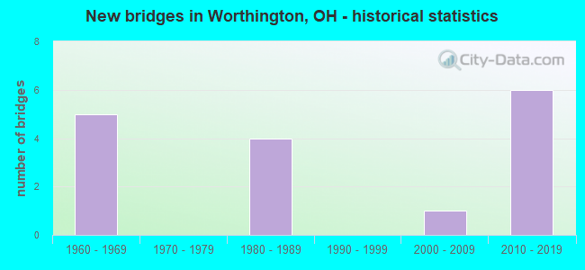
- New bridges - historical statistics
- 51960-1969
- 41980-1989
- 12000-2009
- 62010-2019
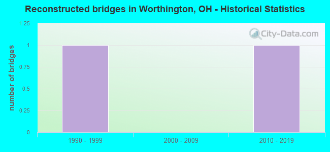
- Reconstructed bridges - Historical Statistics
- 11990-1999
- 02000-2009
- 12010-2019
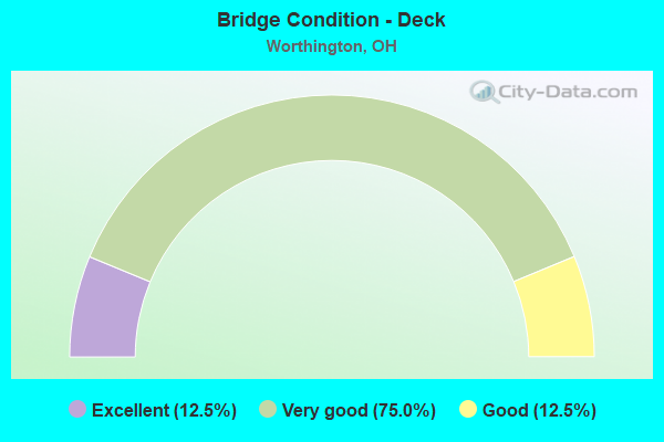
- Bridge Condition - Deck
- 12.5%Excellent
- 75.0%Very good
- 12.5%Good
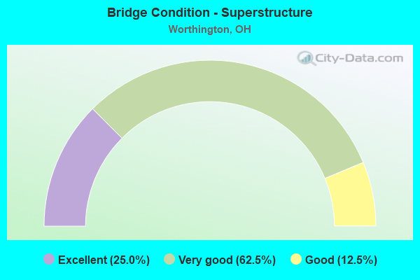
- Bridge Condition - Superstructure
- 25.0%Excellent
- 62.5%Very good
- 12.5%Good
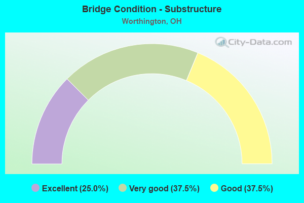
- Bridge Condition - Substructure
- 25.0%Excellent
- 37.5%Very good
- 37.5%Good
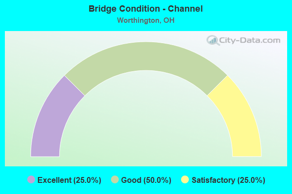
- Bridge Condition - Channel
- 25.0%Excellent
- 50.0%Good
- 25.0%Satisfactory
Find on map >> Show street view
Structure Number: 251585, Location: 0.07 MI E OF SHARF RD (Lat: 40.772031, Lng: -84.378139), Route carried "on" structure: County highway T0026, Year Built: 2009, Status: Open, Structure Length: 1.92m (6.30ft), Average Daily Traffic: 81 (year 2015), Truck Traffic: 9%, Average Future Daily Traffic: 112 (year 2035), Design Load: HL 93, Features Intersected: JENNINGS CRK - FRUEND RD, Facility Carried by Structure: FRUEND RD
Minimum Vertical Clearance: 30+ m (98+ ft), Kilometerpoint: 1.593, Lanes on structure: 2, Owner: County Highway Agency, Approaching Roadway Width: 6.7m (22.0ft), Skew: 3 degrees, Material/Design: Prestressed concrete, Design/Construction: Box Beam or Girders - Multiple, Number Of Spans In Main Unit: 1, Length of Maximum Span: 18.3m (60.0ft), Curb-To-Curb Width: 8.5m (27.9ft), Out-to-Out Width: 8.5m (27.9ft)
Condition: Deck: Very good, Superstructure: Very good, Substructure: Very good, Channel: Excellent, Operating Rating: 42.1 metric tons, Method Used To Determine Operating Rating: Load and Resistance Factor Rating (LRFR) rating reported by rating factor(RF) method using HL-93 loadings, Inventory Rating: 32.4 metric tons, Method Used To Determine Inventory Rating: Load and Resistance Factor Rating (LRFR) rating reported by rating factor(RF) method using HL-93 loadings, Structural Evaluation: Equal to present desirable criteria, Deck Geometry: Better than present minimum criteria, Waterway Adequacy: Equal to present desirable criteria, Approach Roadway Alignment: Equal to present desirable criteria, Designated Inspection Frequency: Every 24 months, Inspection Date: June 2021, Deck Structure Type: Concrete Cast-file-Place, Wearing Surface/Protective System: Wearing Surface: Bituminous
Find on map >> Show street view
Structure Number: 2508958, Location: 4.03 MI E OF US33 (Lat: 40.089431, Lng: -83.036111), Route carried "on" structure: State highway 161, Year Built: 1980, Status: Open, Structure Length: 7.95m (26.08ft), Average Daily Traffic: 24,864 (year 2015), Truck Traffic: 2%, Average Future Daily Traffic: 34,511 (year 2035), Design Load: HS 20+Mod, Features Intersected: OVER SR 315
Minimum Vertical Clearance: 30+ m (98+ ft), Kilometerpoint: 14.130, Lanes on structure: 5, Lanes under structure: 6, Base Highway Network: Yes, Owner: State Highway Agency, Approaching Roadway Width: 24.4m (80.1ft), Skew: 1 degrees, Material/Design: Steel continuous, Design/Construction: Stringer/Multi-beam, Number Of Spans In Main Unit: 4, Length of Maximum Span: 24.4m (80.1ft), Curb or Sidewalk Widths: Left: 1.5m (4.9ft), Right: 0.0m, Curb-To-Curb Width: 24.4m (80.1ft), Out-to-Out Width: 26.8m (87.9ft)
Condition: Deck: Very good, Superstructure: Very good, Substructure: Very good, Operating Rating: 42.1 metric tons, Method Used To Determine Operating Rating: Load and Resistance Factor Rating (LRFR) rating reported by rating factor(RF) method using HL-93 loadings, Inventory Rating: 32.4 metric tons, Method Used To Determine Inventory Rating: Load and Resistance Factor Rating (LRFR) rating reported by rating factor(RF) method using HL-93 loadings, Structural Evaluation: Equal to present desirable criteria, Deck Geometry: Superior to present desirable criteria, Underclear: Meets minimum limits, Approach Roadway Alignment: Equal to present desirable criteria, Designated Inspection Frequency: Every 24 months, Inspection Date: June 2020, Deck Structure Type: Concrete Cast-file-Place, Wearing Surface/Protective System: Wearing Surface: Integral Concrete, Membrane: Built-up
Find on map >> Show street view
Structure Number: 2508966, Location: 0.12 MI E OF SR315 (Lat: 40.089389, Lng: -83.034419), Route carried "on" structure: State highway 161, Year Built: 1980, Status: Open, Structure Length: 10.03m (32.91ft), Average Daily Traffic: 25,076 (year 2015), Truck Traffic: 2%, Average Future Daily Traffic: 34,805 (year 2035), Design Load: HS 20, Features Intersected: OLENTANGY RIVER
Minimum Vertical Clearance: 30+ m (98+ ft), Kilometerpoint: 14.323, Lanes on structure: 4, Base Highway Network: Yes, Owner: State Highway Agency, Approaching Roadway Width: 24.4m (80.1ft), Skew: 3 degrees, Material/Design: Prestressed concrete, Design/Construction: Stringer/Multi-beam, Number Of Spans In Main Unit: 4, Length of Maximum Span: 24.6m (80.7ft), Curb or Sidewalk Widths: Left: 1.5m (4.9ft), Right: 3.7m (12.1ft), Curb-To-Curb Width: 20.7m (67.9ft), Out-to-Out Width: 26.8m (87.9ft)
Condition: Deck: Very good, Superstructure: Very good, Substructure: Very good, Channel: Good, Operating Rating: 81.0 metric tons, Method Used To Determine Operating Rating: Load and Resistance Factor Rating (LRFR) rating reported by rating factor(RF) method using HL-93 loadings, Inventory Rating: 42.1 metric tons, Method Used To Determine Inventory Rating: Load and Resistance Factor Rating (LRFR) rating reported by rating factor(RF) method using HL-93 loadings, Structural Evaluation: Equal to present desirable criteria, Deck Geometry: Superior to present desirable criteria, Waterway Adequacy: Equal to present desirable criteria, Approach Roadway Alignment: Equal to present desirable criteria, Designated Inspection Frequency: Every 24 months, Inspection Date: June 2020, Deck Structure Type: Concrete Cast-file-Place, Wearing Surface/Protective System: Wearing Surface: Bituminous, Membrane: Built-up
Find on map >> Show street view
Structure Number: 2511002, Location: US-23 over I-270 (Lat: 40.112019, Lng: -83.016611), Route carried "on" structure: US 23, Year Built: 2017, Status: Open, Structure Length: 8.93m (29.30ft), Average Daily Traffic: 90,220 (year 2020), Truck Traffic: 6%, Average Future Daily Traffic: 105,320 (year 2040), Design Load: HL 93, Features Intersected: US23 OVER IR270
Minimum Vertical Clearance: 30+ m (98+ ft), Kilometerpoint: 36.870, Lanes on structure: 9, Lanes under structure: 13, Base Highway Network: Yes, Owner: State Highway Agency, Approaching Roadway Width: 9.1m (29.9ft), Skew: 10 degrees, Material/Design: Steel continuous, Design/Construction: Stringer/Multi-beam, Number Of Spans In Main Unit: 2, Length of Maximum Span: 46.6m (152.9ft), Curb or Sidewalk Widths: Left: 0.0m, Right: 3.0m (9.8ft), Curb-To-Curb Width: 43.3m (142.1ft), Out-to-Out Width: 44.2m (145.0ft)
Condition: Deck: Very good, Superstructure: Excellent, Substructure: Excellent, Operating Rating: 68.0 metric tons, Method Used To Determine Operating Rating: Load and Resistance Factor Rating (LRFR) rating reported by rating factor(RF) method using HL-93 loadings, Inventory Rating: 51.8 metric tons, Method Used To Determine Inventory Rating: Load and Resistance Factor Rating (LRFR) rating reported by rating factor(RF) method using HL-93 loadings, Structural Evaluation: Superior to present desirable criteria, Deck Geometry: Superior to present desirable criteria, Underclear: Meets minimum limits, Approach Roadway Alignment: Equal to present desirable criteria, Designated Inspection Frequency: Every 24 months, Inspection Date: March 2021, Deck Structure Type: Concrete Cast-file-Place, Wearing Surface/Protective System: Wearing Surface: Monolithic Concrete, Deck Protection: Epoxy Coated Reinforcing
Find on map >> Show street view
Structure Number: 2511045, Location: 0.68 MI E OF US23 (Lat: 40.111569, Lng: -83.003969), Route carried "on" structure: Interstate 270, Year Built: 1966, Year Reconstructed: 2010, Status: Open, Structure Length: 6.78m (22.24ft), Average Daily Traffic: 172,736 (year 2015), Truck Traffic: 13%, Average Future Daily Traffic: 239,758 (year 2035), Design Load: HS 20+Mod, Features Intersected: OVER NS & CSXT RAILROADS
Minimum Vertical Clearance: 30+ m (98+ ft), Kilometerpoint: 39.365, Lanes on structure: 12, Base Highway Network: Yes, Owner: State Highway Agency, Approaching Roadway Width: 59.3m (194.6ft), Skew: 30 degrees, Material/Design: Steel continuous, Design/Construction: Stringer/Multi-beam, Number Of Spans In Main Unit: 4, Length of Maximum Span: 19.5m (64.0ft), Curb-To-Curb Width: 59.3m (194.6ft), Out-to-Out Width: 60.2m (197.5ft)
Condition: Deck: Very good, Superstructure: Very good, Substructure: Good, Operating Rating: 97.2 metric tons, Method Used To Determine Operating Rating: Load Factor (LF) rating reported by rating factor (RF) method using MS18 loading, Inventory Rating: 71.3 metric tons, Method Used To Determine Inventory Rating: Load Factor (LF) rating reported by rating factor (RF) method using MS18 loading, Structural Evaluation: Better than present minimum criteria, Deck Geometry: Superior to present desirable criteria, Underclear: Better than present minimum criteria, Approach Roadway Alignment: Better than present minimum criteria, Designated Inspection Frequency: Every 24 months, Inspection Date: July 2021, Deck Structure Type: Concrete Cast-file-Place, Wearing Surface/Protective System: Wearing Surface: Monolithic Concrete, Deck Protection: Epoxy Coated Reinforcing
Find on map >> Show street view
Structure Number: 2511169, Location: 1.08 MI E OF US23 (Lat: 40.111181, Lng: -82.996161), Route carried "on" structure: Interstate 270, Year Built: 1966, Year Reconstructed: 2001, Status: Open, Structure Length: 5.07m (16.63ft), Average Daily Traffic: 172,736 (year 2015), Truck Traffic: 13%, Average Future Daily Traffic: 239,758 (year 2035), Design Load: HS 20+Mod, Features Intersected: OVER WORTHINGTON-GALENA
Minimum Vertical Clearance: 30+ m (98+ ft), Kilometerpoint: 40.008, Lanes on structure: 12, Lanes under structure: 2, Base Highway Network: Yes, Owner: State Highway Agency, Approaching Roadway Width: 58.1m (190.6ft), Skew: 31 degrees, Material/Design: Concrete continuous, Design/Construction: Slab, Number Of Spans In Main Unit: 4, Length of Maximum Span: 13.7m (44.9ft), Curb-To-Curb Width: 58.0m (190.3ft), Out-to-Out Width: 58.9m (193.2ft)
Condition: Deck: Very good, Superstructure: Very good, Substructure: Good, Operating Rating: 68.0 metric tons, Method Used To Determine Operating Rating: Load Factor (LF) rating reported by rating factor (RF) method using MS18 loading, Inventory Rating: 38.9 metric tons, Method Used To Determine Inventory Rating: Load Factor (LF) rating reported by rating factor (RF) method using MS18 loading, Structural Evaluation: Better than present minimum criteria, Deck Geometry: Superior to present desirable criteria, Underclear: Meets minimum limits, Approach Roadway Alignment: Equal to present desirable criteria, Designated Inspection Frequency: Every 24 months, Inspection Date: July 2021, Deck Structure Type: Concrete Cast-file-Place, Wearing Surface/Protective System: Wearing Surface: Monolithic Concrete, Deck Protection: Epoxy Coated Reinforcing
Find on map >> Show street view
Structure Number: 2515857, Location: 0.20 MI S OF 270 (Lat: 40.109261, Lng: -83.035931), Route carried "on" structure: Ramp State highway 315, Year Built: 2017, Status: Open, Structure Length: 11.37m (37.30ft), Average Daily Traffic: 11,366 (year 2013), Truck Traffic: 3%, Average Future Daily Traffic: 12,309 (year 2033), Design Load: HS 20, Features Intersected: RAMP 315-G OVER SR 315
Minimum Vertical Clearance: 30+ m (98+ ft), Kilometerpoint: 18.990, Lanes on structure: 1, Lanes under structure: 6, Owner: State Highway Agency, Approaching Roadway Width: 11.0m (36.1ft), Material/Design: Steel continuous, Design/Construction: Stringer/Multi-beam, Number Of Spans In Main Unit: 3, Length of Maximum Span: 47.2m (154.9ft), Curb-To-Curb Width: 11.0m (36.1ft), Out-to-Out Width: 11.9m (39.0ft)
Condition: Deck: Excellent, Superstructure: Excellent, Substructure: Excellent, Operating Rating: 48.6 metric tons, Method Used To Determine Operating Rating: Load Factor (LF) rating reported by rating factor (RF) method using MS18 loading, Inventory Rating: 29.2 metric tons, Method Used To Determine Inventory Rating: Load Factor (LF) rating reported by rating factor (RF) method using MS18 loading, Structural Evaluation: Better than present minimum criteria, Deck Geometry: Superior to present desirable criteria, Underclear: Equal to present minimum criteria, Approach Roadway Alignment: Equal to present desirable criteria, Length Of Structure Improvement: 11.39m (37.37ft), Designated Inspection Frequency: Every 24 months, Inspection Date: July 2021, Deck Structure Type: Concrete Cast-file-Place, Wearing Surface/Protective System: Wearing Surface: Monolithic Concrete
Find on map >> Show street view
Structure Number: 2515903, Location: 0.34 MI S OF S 270 (Lat: 40.107200, Lng: -83.036089), Route carried "on" structure: County highway C0064, Year Built: 1969, Status: Open, Structure Length: 16.95m (55.61ft), Average Daily Traffic: 23,352 (year 2015), Truck Traffic: 5%, Average Future Daily Traffic: 127,904 (year 2035), Design Load: H 20, Features Intersected: SR 315, Facility Carried by Structure: WILSON BRIDGE RD
Minimum Vertical Clearance: 30+ m (98+ ft), Kilometerpoint: 0.000, Lanes on structure: 2, Lanes under structure: 6, Owner: State Highway Agency, Approaching Roadway Width: 11.6m (38.1ft), Material/Design: Steel continuous, Design/Construction: Stringer/Multi-beam, Number Of Spans In Main Unit: 6, Length of Maximum Span: 33.5m (109.9ft), Curb-To-Curb Width: 9.8m (32.2ft), Out-to-Out Width: 11.0m (36.1ft)
Condition: Deck: Good, Superstructure: Good, Substructure: Good, Channel: Good, Operating Rating: 42.1 metric tons, Method Used To Determine Operating Rating: Load Factor (LF) rating reported by rating factor (RF) method using MS18 loading, Inventory Rating: 32.4 metric tons, Method Used To Determine Inventory Rating: Load Factor (LF) rating reported by rating factor (RF) method using MS18 loading, Structural Evaluation: Better than present minimum criteria, Deck Geometry: Meets minimum limits, Underclear: High priority of corrective action, Waterway Adequacy: Equal to present desirable criteria, Approach Roadway Alignment: Equal to present desirable criteria, Designated Inspection Frequency: Every 24 months, Inspection Date: July 2021, Deck Structure Type: Concrete Cast-file-Place, Wearing Surface/Protective System: Wearing Surface: Integral Concrete
Find on map >> Show street view
Structure Number: 25611, Location: 0.13 MILE W. OF US-23 (Lat: 40.077681, Lng: -83.021019), Route carried "on" structure: City street SELBY, Year Built: 1982, Status: Posted for load, Structure Length: 1.01m (3.31ft), Average Daily Traffic: 300 (year 2020), Truck Traffic: 1%, Average Future Daily Traffic: 2,803 (year 2040), Design Load: HS 20, Features Intersected: RUSH RUN
Minimum Vertical Clearance: 30+ m (98+ ft), Kilometerpoint: 0.319, Lanes on structure: 2, Owner: City or Municipal Highway Agency, Approaching Roadway Width: 8.2m (26.9ft), Skew: 3 degrees, Material/Design: Concrete, Design/Construction: Culvert, Number Of Spans In Main Unit: 2, Length of Maximum Span: 4.3m (14.1ft), Curb or Sidewalk Widths: Left: 3.0m (9.8ft), Right: 3.0m (9.8ft)
Condition: Channel: Satisfactory, Culverts: Poor, Operating Rating: 16.2 metric tons, Method Used To Determine Operating Rating: Load and Resistance Factor Rating (LRFR) rating reported by rating factor(RF) method using HL-93 loadings, Inventory Rating: 13.0 metric tons, Method Used To Determine Inventory Rating: Load and Resistance Factor Rating (LRFR) rating reported by rating factor(RF) method using HL-93 loadings, Structural Evaluation: Meets minimum limits, Waterway Adequacy: Equal to present desirable criteria, Approach Roadway Alignment: Equal to present desirable criteria, Bridge Posting: Required (Relationship of Operating Rating to Maximum Legal Load: > 39.9% below), Designated Inspection Frequency: Every 12 months, Inspection Date: June 2021
Find on map >> Show street view
Structure Number: 2508958, Location: 4.03 MI E OF US33 (Lat: 40.089431, Lng: -83.036111), Route carried "under" structure: State highway 315, Year Built: 1980, Structure Length: 0. m, Average Daily Traffic: 82,803 (year 2015), Truck Traffic: 3%, Features Intersected: SR 161, Facility Carried by Structure: SR 161
Minimum Vertical Clearance: 5.05m (16.57ft), Kilometerpoint: 16.785, Lanes on structure: 5, Lanes under structure: 6, Material/Design: Steel continuous, Design/Construction: Stringer/Multi-beam, Length of Maximum Span: 24.4m (80.1ft)
Find on map >> Show street view
Structure Number: 2511002, Location: US-23 over I-270 (Lat: 40.112019, Lng: -83.016611), Route carried "under" structure: Interstate 270, Year Built: 2017, Structure Length: 0. m, Average Daily Traffic: 20,000 (year 2018), Truck Traffic: 13%, Features Intersected: US 23, Facility Carried by Structure: US 23
Minimum Vertical Clearance: 5.18m (16.99ft), Kilometerpoint: 38.248, Lanes on structure: 9, Lanes under structure: 13, Material/Design: Steel continuous, Design/Construction: Stringer/Multi-beam, Length of Maximum Span: 46.6m (152.9ft)
Find on map >> Show street view
Structure Number: 2511002, Location: US-23 over I-270 (Lat: 40.112019, Lng: -83.016611), Route carried "under" structure: Ramp Interstate 270, Year Built: 2017, Structure Length: 0. m, Average Daily Traffic: 1,000 (year 2018), Truck Traffic: 10%, Features Intersected: US 23, Facility Carried by Structure: US 23
Minimum Vertical Clearance: 5.18m (16.99ft), Kilometerpoint: 38.222, Lanes on structure: 9, Lanes under structure: 13, Material/Design: Steel continuous, Design/Construction: Stringer/Multi-beam, Length of Maximum Span: 46.6m (152.9ft)
Find on map >> Show street view
Structure Number: 2511002, Location: US-23 over I-270 (Lat: 40.112019, Lng: -83.016611), Route carried "under" structure: Ramp Interstate 270, Year Built: 2017, Structure Length: 0. m, Average Daily Traffic: 1,000 (year 2018), Truck Traffic: 10%, Features Intersected: US 23, Facility Carried by Structure: US 23
Minimum Vertical Clearance: 5.18m (16.99ft), Kilometerpoint: 38.254, Lanes on structure: 9, Lanes under structure: 13, Material/Design: Steel continuous, Design/Construction: Stringer/Multi-beam, Length of Maximum Span: 46.6m (152.9ft)
Find on map >> Show street view
Structure Number: 2511169, Location: 1.08 MI E OF US23 (Lat: 40.111181, Lng: -82.996161), Route carried "under" structure: County highway 84, Year Built: 1966, Structure Length: 0. m, Average Daily Traffic: 20,791 (year 2015), Truck Traffic: 1%, Features Intersected: IR 270WB, Facility Carried by Structure: I-270
Minimum Vertical Clearance: 4.70m (15.42ft), Kilometerpoint: 0.000, Lanes on structure: 12, Lanes under structure: 2, Material/Design: Concrete continuous, Design/Construction: Slab, Length of Maximum Span: 13.7m (44.9ft)
Find on map >> Show street view
Structure Number: 2515857, Location: 0.20 MI S OF 270 (Lat: 40.109261, Lng: -83.035931), Route carried "under" structure: State highway 315, Year Built: 2017, Structure Length: 0. m, Average Daily Traffic: 79,969 (year 2016), Truck Traffic: 4%, Features Intersected: SR 315
Minimum Vertical Clearance: 5.64m (18.50ft), Kilometerpoint: 19.022, Lanes on structure: 1, Lanes under structure: 6, Material/Design: Steel continuous, Design/Construction: Stringer/Multi-beam, Length of Maximum Span: 47.2m (154.9ft)
Find on map >> Show street view
Structure Number: 2515903, Location: 0.34 MI S OF S 270 (Lat: 40.107200, Lng: -83.036089), Route carried "under" structure: State highway 315, Year Built: 1969, Structure Length: 0. m, Average Daily Traffic: 92,150 (year 2015), Truck Traffic: 3%, Features Intersected: UNDER WILSON BRIDGE ROAD, Facility Carried by Structure: WILSON BRIDGE RD
Minimum Vertical Clearance: 4.54m (14.90ft), Kilometerpoint: 18.765, Lanes on structure: 2, Lanes under structure: 6, Material/Design: Steel continuous, Design/Construction: Stringer/Multi-beam, Length of Maximum Span: 33.5m (109.9ft)