Bridge Statistics for Woodhaven, Michigan (MI)
Condition, Traffic, Stress, Structural Evaluation, Project Costs
- National Bridge Inventory (NBI) Statistics
- 23Number of bridges
- 184ft / 55.6mTotal length
- $343,000Total costs
- 743,212Total average daily traffic
- 118,175Total average daily truck traffic
- National Bridge Inventory (NBI) Registered Bridges for Woodhaven
- No street view available for this location
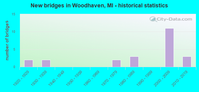
- New bridges - historical statistics
- 21920-1929
- 21930-1939
- 21970-1979
- 31980-1989
- 112000-2009
- 32010-2019

- Reconstructed bridges - Historical Statistics
- 11950-1959
- 11960-1969


- Bridge Condition - Deck
- 15.4%Very good
- 61.5%Good
- 7.7%Satisfactory
- 15.4%Fair

- Bridge Condition - Superstructure
- 38.5%Very good
- 30.8%Good
- 15.4%Satisfactory
- 7.7%Fair
- 7.7%Poor

- Bridge Condition - Substructure
- 30.8%Very good
- 53.8%Good
- 15.4%Fair

- Bridge Condition - Channel
- 12.5%Very good
- 37.5%Good
- 12.5%Satisfactory
- 25.0%Fair
- 12.5%Poor

- Bridge Condition - Culverts
- 33.3%Very good
- 33.3%Good
- 33.3%Satisfactory
Find on map >> Show street view
Structure Number: 1165, Location: GIRARD TWP SEC 17 (Lat: 42.042267, Lng: -85.025547), Route carried "on" structure: County highway , Year Built: 1978, Status: Posted for load, Structure Length: 2.07m (6.79ft), Average Daily Traffic: 305 (year 2004), Truck Traffic: 4%, Average Future Daily Traffic: 322 (year 2024), Design Load: HS 20+Mod, Features Intersected: HOG CREEK, Facility Carried by Structure: BELL ROAD
Minimum Vertical Clearance: 30.48m (100.00ft), Kilometerpoint: 3.108, Lanes on structure: 2, Owner: County Highway Agency, Approaching Roadway Width: 9.1m (29.9ft), Material/Design: Wood or Timber, Design/Construction: Slab, Number Of Spans In Main Unit: 3, Length of Maximum Span: 9.6m (31.5ft), Curb-To-Curb Width: 9.1m (29.9ft), Out-to-Out Width: 9.7m (31.8ft)
Condition: Deck: Satisfactory, Superstructure: Satisfactory, Substructure: Good, Channel: Good, Operating Rating: 37.0 metric tons, Method Used To Determine Operating Rating: Load Factor (LF), Inventory Rating: 25.0 metric tons, Method Used To Determine Inventory Rating: Load Factor (LF), Structural Evaluation: Equal to present minimum criteria, Deck Geometry: Equal to present minimum criteria, Waterway Adequacy: Equal to present desirable criteria, Approach Roadway Alignment: Equal to present minimum criteria, Bridge Posting: Required (Relationship of Operating Rating to Maximum Legal Load: > 39.9% below), Length Of Structure Improvement: 2.07m (6.79ft), Designated Inspection Frequency: Every 24 months, Inspection Date: October 2020, Bridge Improvement Cost: $257,000, Roadway Improvement Cost: $20,000, Total Project Cost: $343,000, Deck Structure Type: Wood or Timber, Wearing Surface/Protective System: Wearing Surface: Bituminous
Find on map >> Show street view
Structure Number: 11634, Location: 4.2 MI N OF N HURON RI DR (Lat: 42.126631, Lng: -83.241172), Route carried "on" structure: Interstate 75, Year Built: 2006, Status: Open, Structure Length: 0.66m (2.17ft), Average Daily Traffic: 53,028 (year 2010), Truck Traffic: 18%, Average Future Daily Traffic: 60,187 (year 2025), Design Load: HS 25 or greater, Features Intersected: BROWNSTOWN CREEK
Minimum Vertical Clearance: 30+ m (98+ ft), Kilometerpoint: 6.785, Lanes on structure: 2, Base Highway Network: Yes (Inventory Route: 159, Subroute: 10), Owner: State Highway Agency, Approaching Roadway Width: 37.5m (123.0ft), Material/Design: Concrete, Design/Construction: Culvert, Number Of Spans In Main Unit: 1, Length of Maximum Span: 6.1m (20.0ft), Out-to-Out Width: 62.2m (204.1ft)
Condition: Channel: Good, Culverts: Satisfactory, Operating Rating: 67.6 metric tons, Method Used To Determine Operating Rating: Field evaluation and documented engineering judgment, Inventory Rating: 40.5 metric tons, Method Used To Determine Inventory Rating: Field evaluation and documented engineering judgment, Structural Evaluation: Equal to present minimum criteria, Waterway Adequacy: Equal to present minimum criteria, Approach Roadway Alignment: Equal to present desirable criteria, Designated Inspection Frequency: Every 24 months, Inspection Date: July 2020
Find on map >> Show street view
Structure Number: 11638, Location: IN WOODHAVEN (Lat: 42.123114, Lng: -83.241200), Route carried "on" structure: Interstate 75, Year Built: 2006, Status: Open, Structure Length: 4.49m (14.73ft), Average Daily Traffic: 36,248 (year 2007), Truck Traffic: 18%, Average Future Daily Traffic: 35,977 (year 2026), Design Load: HS 25 or greater, Features Intersected: GTW RR
Minimum Vertical Clearance: 30.48m (100.00ft), Kilometerpoint: 6.407, Lanes on structure: 3, Base Highway Network: Yes (Inventory Route: 159, Subroute: 10), Owner: State Highway Agency, Approaching Roadway Width: 18.3m (60.0ft), Skew: 13 degrees, Material/Design: Steel, Design/Construction: Stringer/Multi-beam, Number Of Spans In Main Unit: 1, Length of Maximum Span: 42.9m (140.7ft), Curb-To-Curb Width: 18.3m (60.0ft), Out-to-Out Width: 19.3m (63.3ft)
Condition: Deck: Very good, Superstructure: Good, Substructure: Good, Operating Rating: 91.4 metric tons, Method Used To Determine Operating Rating: Load Factor (LF) rating reported by rating factor (RF) method using MS18 loading, Inventory Rating: 54.8 metric tons, Method Used To Determine Inventory Rating: Load Factor (LF) rating reported by rating factor (RF) method using MS18 loading, Structural Evaluation: Better than present minimum criteria, Deck Geometry: Better than present minimum criteria, Approach Roadway Alignment: Equal to present desirable criteria, Designated Inspection Frequency: Every 24 months, Inspection Date: July 2020, Deck Structure Type: Concrete Cast-file-Place, Wearing Surface/Protective System: Wearing Surface: Integral Concrete, Deck Protection: Epoxy Coated Reinforcing
Find on map >> Show street view
Structure Number: 11639, Location: IN WOODHAVEN (Lat: 42.123008, Lng: -83.241464), Route carried "on" structure: Interstate 75, Year Built: 2006, Status: Open, Structure Length: 4.49m (14.73ft), Average Daily Traffic: 36,248 (year 2007), Truck Traffic: 18%, Average Future Daily Traffic: 35,977 (year 2026), Design Load: HS 25 or greater, Features Intersected: GTW RR
Minimum Vertical Clearance: 30.48m (100.00ft), Kilometerpoint: 6.368, Lanes on structure: 3, Base Highway Network: Yes (Inventory Route: 159, Subroute: 6), Owner: State Highway Agency, Approaching Roadway Width: 18.3m (60.0ft), Skew: 13 degrees, Material/Design: Steel, Design/Construction: Stringer/Multi-beam, Number Of Spans In Main Unit: 1, Length of Maximum Span: 42.9m (140.7ft), Curb-To-Curb Width: 18.3m (60.0ft), Out-to-Out Width: 19.3m (63.3ft)
Condition: Deck: Very good, Superstructure: Very good, Substructure: Good, Operating Rating: 92.7 metric tons, Method Used To Determine Operating Rating: Load Factor (LF) rating reported by rating factor (RF) method using MS18 loading, Inventory Rating: 55.7 metric tons, Method Used To Determine Inventory Rating: Load Factor (LF) rating reported by rating factor (RF) method using MS18 loading, Structural Evaluation: Better than present minimum criteria, Deck Geometry: Better than present minimum criteria, Approach Roadway Alignment: Equal to present desirable criteria, Designated Inspection Frequency: Every 24 months, Inspection Date: July 2020, Deck Structure Type: Concrete Cast-file-Place, Wearing Surface/Protective System: Wearing Surface: Integral Concrete, Deck Protection: Epoxy Coated Reinforcing
Find on map >> Show street view
Structure Number: 11646, Location: S LTS OF WOODHAVEN (Lat: 42.109650, Lng: -83.241375), Route carried "on" structure: County highway , Year Built: 2002, Status: Open, Structure Length: 5.64m (18.50ft), Average Daily Traffic: 3,594 (year 1995), Truck Traffic: 2%, Average Future Daily Traffic: 11,700 (year 2020), Design Load: HS 20, Features Intersected: I-75, Facility Carried by Structure: VREELAND RD
Minimum Vertical Clearance: 30.48m (100.00ft), Kilometerpoint: 3.640, Lanes on structure: 2, Lanes under structure: 6, Owner: State Highway Agency, Approaching Roadway Width: 12.2m (40.0ft), Material/Design: Prestressed concrete, Design/Construction: Box Beam or Girders - Multiple, Number Of Spans In Main Unit: 2, Length of Maximum Span: 28.2m (92.5ft), Curb-To-Curb Width: 12.4m (40.7ft), Out-to-Out Width: 13.4m (44.0ft)
Condition: Deck: Good, Superstructure: Good, Substructure: Good, Operating Rating: 76.9 metric tons, Method Used To Determine Operating Rating: Load Factor (LF), Inventory Rating: 46.0 metric tons, Method Used To Determine Inventory Rating: Load Factor (LF), Structural Evaluation: Better than present minimum criteria, Deck Geometry: Equal to present minimum criteria, Underclear: High priority of corrective action, Approach Roadway Alignment: Equal to present desirable criteria, Designated Inspection Frequency: Every 24 months, Inspection Date: May 2020, Deck Structure Type: Concrete Cast-file-Place, Wearing Surface/Protective System: Wearing Surface: Monolithic Concrete, Deck Protection: Epoxy Coated Reinforcing
Find on map >> Show street view
Structure Number: 11647, Location: IN WOODHAVEN (Lat: 42.124381, Lng: -83.241186), Route carried "on" structure: Interstate 75, Year Built: 2006, Status: Open, Structure Length: 4.88m (16.01ft), Average Daily Traffic: 36,248 (year 2007), Truck Traffic: 18%, Average Future Daily Traffic: 35,977 (year 2026), Design Load: HS 25 or greater, Features Intersected: VAN HORN RD
Minimum Vertical Clearance: 30.48m (100.00ft), Kilometerpoint: 6.536, Lanes on structure: 3, Lanes under structure: 2, Base Highway Network: Yes (Inventory Route: 159, Subroute: 10), Owner: State Highway Agency, Approaching Roadway Width: 18.4m (60.4ft), Skew: 10 degrees, Material/Design: Steel, Design/Construction: Stringer/Multi-beam, Number Of Spans In Main Unit: 1, Length of Maximum Span: 46.8m (153.5ft), Curb-To-Curb Width: 18.3m (60.0ft), Out-to-Out Width: 19.3m (63.3ft)
Condition: Deck: Good, Superstructure: Very good, Substructure: Good, Operating Rating: 97.2 metric tons, Method Used To Determine Operating Rating: Load Factor (LF) rating reported by rating factor (RF) method using MS18 loading, Inventory Rating: 61.6 metric tons, Method Used To Determine Inventory Rating: Load Factor (LF) rating reported by rating factor (RF) method using MS18 loading, Structural Evaluation: Better than present minimum criteria, Deck Geometry: Better than present minimum criteria, Underclear: Somewhat better than minimum adequacy, Approach Roadway Alignment: Equal to present desirable criteria, Designated Inspection Frequency: Every 24 months, Inspection Date: July 2020, Deck Structure Type: Concrete Cast-file-Place, Wearing Surface/Protective System: Wearing Surface: Integral Concrete, Deck Protection: Epoxy Coated Reinforcing
Find on map >> Show street view
Structure Number: 11648, Location: IN WOODHAVEN (Lat: 42.124356, Lng: -83.241472), Route carried "on" structure: Interstate 75, Year Built: 2006, Status: Open, Structure Length: 4.88m (16.01ft), Average Daily Traffic: 36,248 (year 2007), Truck Traffic: 18%, Average Future Daily Traffic: 35,977 (year 2026), Design Load: HS 25 or greater, Features Intersected: VAN HORN RD
Minimum Vertical Clearance: 30.48m (100.00ft), Kilometerpoint: 6.504, Lanes on structure: 3, Lanes under structure: 2, Base Highway Network: Yes (Inventory Route: 159, Subroute: 6), Owner: State Highway Agency, Approaching Roadway Width: 17.0m (55.8ft), Skew: 10 degrees, Material/Design: Steel, Design/Construction: Stringer/Multi-beam, Number Of Spans In Main Unit: 1, Length of Maximum Span: 46.8m (153.5ft), Curb-To-Curb Width: 18.3m (60.0ft), Out-to-Out Width: 19.3m (63.3ft)
Condition: Deck: Good, Superstructure: Very good, Substructure: Very good, Operating Rating: 97.2 metric tons, Method Used To Determine Operating Rating: Load Factor (LF) rating reported by rating factor (RF) method using MS18 loading, Inventory Rating: 62.5 metric tons, Method Used To Determine Inventory Rating: Load Factor (LF) rating reported by rating factor (RF) method using MS18 loading, Structural Evaluation: Equal to present desirable criteria, Deck Geometry: Better than present minimum criteria, Underclear: Somewhat better than minimum adequacy, Approach Roadway Alignment: Equal to present desirable criteria, Designated Inspection Frequency: Every 24 months, Inspection Date: July 2020, Deck Structure Type: Concrete Cast-file-Place, Wearing Surface/Protective System: Wearing Surface: Integral Concrete, Deck Protection: Epoxy Coated Reinforcing
Find on map >> Show street view
Structure Number: 11649, Location: IN WOODHAVEN (Lat: 42.138814, Lng: -83.241439), Route carried "on" structure: County highway 2057, Year Built: 1986, Status: Open, Structure Length: 7.04m (23.10ft), Average Daily Traffic: 35,300 (year 2005), Truck Traffic: 15%, Average Future Daily Traffic: 40,595 (year 2025), Design Load: HS 25 or greater, Features Intersected: I-75, Facility Carried by Structure: WEST RD
Minimum Vertical Clearance: 30.48m (100.00ft), Kilometerpoint: 10.072, Lanes on structure: 5, Lanes under structure: 8, Base Highway Network: Yes (Inventory Route: 167, Subroute: 10), Owner: State Highway Agency, Approaching Roadway Width: 26.8m (87.9ft), Material/Design: Steel, Design/Construction: Stringer/Multi-beam, Number Of Spans In Main Unit: 4, Length of Maximum Span: 20.4m (66.9ft), Curb or Sidewalk Widths: Left: 4.3m (14.1ft), Right: 0.0m, Curb-To-Curb Width: 29.2m (95.8ft), Out-to-Out Width: 37.0m (121.4ft)
Condition: Deck: Good, Superstructure: Good, Substructure: Very good, Operating Rating: 69.7 metric tons, Method Used To Determine Operating Rating: Load Factor (LF) rating reported by rating factor (RF) method using MS18 loading, Inventory Rating: 41.8 metric tons, Method Used To Determine Inventory Rating: Load Factor (LF) rating reported by rating factor (RF) method using MS18 loading, Structural Evaluation: Better than present minimum criteria, Deck Geometry: Superior to present desirable criteria, Underclear: High priority of corrective action, Approach Roadway Alignment: Equal to present desirable criteria, Designated Inspection Frequency: Every 24 months, Inspection Date: July 2020, Deck Structure Type: Concrete Cast-file-Place, Wearing Surface/Protective System: Wearing Surface: Epoxy Overlay, Deck Protection: Epoxy Coated Reinforcing
Find on map >> Show street view
Structure Number: 1165, Location: N LTS OF WOODHAVEN (Lat: 42.154578, Lng: -83.242244), Route carried "on" structure: County highway 2057, Year Built: 2006, Status: Open, Structure Length: 6.76m (22.18ft), Average Daily Traffic: 7,300 (year 2006), Truck Traffic: 3%, Average Future Daily Traffic: 9,500 (year 2026), Design Load: HS 20+Mod, Features Intersected: I-75, Facility Carried by Structure: KING RD
Minimum Vertical Clearance: 30.48m (100.00ft), Kilometerpoint: 5.232, Lanes on structure: 2, Lanes under structure: 6, Owner: State Highway Agency, Approaching Roadway Width: 12.2m (40.0ft), Material/Design: Steel, Design/Construction: Stringer/Multi-beam, Number Of Spans In Main Unit: 2, Length of Maximum Span: 34.5m (113.2ft), Curb-To-Curb Width: 13.4m (44.0ft), Out-to-Out Width: 18.5m (60.7ft)
Condition: Deck: Good, Superstructure: Very good, Substructure: Very good, Operating Rating: 69.7 metric tons, Method Used To Determine Operating Rating: Load Factor (LF), Inventory Rating: 41.7 metric tons, Method Used To Determine Inventory Rating: Load Factor (LF), Structural Evaluation: Equal to present desirable criteria, Deck Geometry: Equal to present minimum criteria, Underclear: High priority of corrective action, Approach Roadway Alignment: Equal to present desirable criteria, Designated Inspection Frequency: Every 24 months, Inspection Date: July 2020, Deck Structure Type: Concrete Cast-file-Place, Wearing Surface/Protective System: Wearing Surface: Integral Concrete, Deck Protection: Epoxy Coated Reinforcing
Find on map >> Show street view
Structure Number: 11999, Location: BRWNTWN/WOODHE/ALLEN (Lat: 42.111797, Lng: -83.222439), Route carried "on" structure: County highway 2057, Year Built: 1925, Year Reconstructed: 1956, Status: Posted for load, Structure Length: 1.70m (5.58ft), Average Daily Traffic: 8,469 (year 1992), Truck Traffic: 5%, Average Future Daily Traffic: 9,739 (year 2015), Design Load: H 20, Features Intersected: BLAKELY DRAIN, Facility Carried by Structure: VREELAND ROAD
Minimum Vertical Clearance: 30.48m (100.00ft), Kilometerpoint: 5.232, Lanes on structure: 2, Owner: County Highway Agency, Approaching Roadway Width: 10.7m (35.1ft), Skew: 2 degrees, Material/Design: Concrete continuous, Design/Construction: Slab, Number Of Spans In Main Unit: 3, Length of Maximum Span: 6.4m (21.0ft), Curb or Sidewalk Widths: Left: 1.8m (5.9ft), Right: 0.0m, Curb-To-Curb Width: 11.3m (37.1ft), Out-to-Out Width: 13.8m (45.3ft)
Condition: Deck: Fair, Superstructure: Fair, Substructure: Fair, Channel: Poor, Operating Rating: 35.0 metric tons, Method Used To Determine Operating Rating: Load Factor (LF) rating reported by rating factor (RF) method using MS18 loading, Inventory Rating: 20.7 metric tons, Method Used To Determine Inventory Rating: Load Factor (LF) rating reported by rating factor (RF) method using MS18 loading, Structural Evaluation: Somewhat better than minimum adequacy, Deck Geometry: Meets minimum limits, Waterway Adequacy: High priority of corrective action, Approach Roadway Alignment: Equal to present desirable criteria, Bridge Posting: Required (Relationship of Operating Rating to Maximum Legal Load: 0.1 - 9.9% below), Designated Inspection Frequency: Every 12 months, Inspection Date: November 2021, Deck Structure Type: Concrete Cast-file-Place, Wearing Surface/Protective System: Wearing Surface: Bituminous
Find on map >> Show street view
Structure Number: 12003, Location: WOODHAVEN E/ALLEN (Lat: 42.126300, Lng: -83.221903), Route carried "on" structure: County highway 2057, Year Built: 1934, Status: Posted for load, Structure Length: 1.04m (3.41ft), Average Daily Traffic: 20,498 (year 1996), Truck Traffic: 5%, Average Future Daily Traffic: 17,636 (year 2015), Features Intersected: BLAKELY DRAIN, Facility Carried by Structure: VAN HORN ROAD
Minimum Vertical Clearance: 30.48m (100.00ft), Kilometerpoint: 10.699, Lanes on structure: 2, Owner: County Highway Agency, Approaching Roadway Width: 12.2m (40.0ft), Material/Design: Concrete, Design/Construction: Tee Beam, Number Of Spans In Main Unit: 1, Length of Maximum Span: 9.1m (29.9ft), Curb-To-Curb Width: 9.1m (29.9ft), Out-to-Out Width: 11.0m (36.1ft)
Condition: Deck: Fair, Superstructure: Poor, Substructure: Fair, Channel: Satisfactory, Operating Rating: 44.4 metric tons, Method Used To Determine Operating Rating: Load Factor (LF) rating reported by rating factor (RF) method using MS18 loading, Inventory Rating: 26.6 metric tons, Method Used To Determine Inventory Rating: Load Factor (LF) rating reported by rating factor (RF) method using MS18 loading, Structural Evaluation: Meets minimum limits, Deck Geometry: High priority of corrective action, Waterway Adequacy: Equal to present desirable criteria, Approach Roadway Alignment: Equal to present minimum criteria, Bridge Posting: Required (Relationship of Operating Rating to Maximum Legal Load: 10.0 - 19.9% below), Designated Inspection Frequency: Every 12 months, Inspection Date: May 2021, Deck Structure Type: Concrete Cast-file-Place, Wearing Surface/Protective System: Wearing Surface: Bituminous
Find on map >> Show street view
Structure Number: 12009, Location: BROWNSTOWNW/TELEGRAPH (Lat: 42.138050, Lng: -83.281097), Route carried "on" structure: County highway 2057, Year Built: 1986, Status: Open, Structure Length: 1.22m (4.00ft), Average Daily Traffic: 11,594 (year 1997), Truck Traffic: 5%, Average Future Daily Traffic: 6,000 (year 2015), Design Load: HS 20, Features Intersected: SMITH CREEK, Facility Carried by Structure: WEST ROAD
Minimum Vertical Clearance: 30.48m (100.00ft), Kilometerpoint: 6.790, Lanes on structure: 2, Owner: County Highway Agency, Approaching Roadway Width: 12.2m (40.0ft), Skew: 2 degrees, Material/Design: Prestressed concrete, Design/Construction: Box Beam or Girders - Multiple, Number Of Spans In Main Unit: 1, Length of Maximum Span: 11.5m (37.7ft), Curb-To-Curb Width: 12.5m (41.0ft), Out-to-Out Width: 13.3m (43.6ft)
Condition: Deck: Good, Superstructure: Good, Substructure: Good, Channel: Fair, Operating Rating: 59.9 metric tons, Method Used To Determine Operating Rating: Load Factor (LF) rating reported by rating factor (RF) method using MS18 loading, Inventory Rating: 36.0 metric tons, Method Used To Determine Inventory Rating: Load Factor (LF) rating reported by rating factor (RF) method using MS18 loading, Structural Evaluation: Better than present minimum criteria, Deck Geometry: Somewhat better than minimum adequacy, Waterway Adequacy: Better than present minimum criteria, Approach Roadway Alignment: Equal to present desirable criteria, Designated Inspection Frequency: Every 24 months, Inspection Date: May 2021, Deck Structure Type: Concrete Cast-file-Place, Wearing Surface/Protective System: Wearing Surface: Monolithic Concrete, Deck Protection: Galvanized Reinforcing
Find on map >> Show street view
Structure Number: 12011, Location: WOODHAVEN E/ALLEN (Lat: 42.140886, Lng: -83.218933), Route carried "on" structure: County highway 2057, Year Built: 1934, Year Reconstructed: 1960, Status: Open, Structure Length: 1.03m (3.38ft), Average Daily Traffic: 32,410 (year 2016), Truck Traffic: 8%, Average Future Daily Traffic: 32,480 (year 2036), Features Intersected: BLAKELY DRAIN, Facility Carried by Structure: WEST ROAD
Minimum Vertical Clearance: 30.48m (100.00ft), Kilometerpoint: 11.950, Lanes on structure: 5, Base Highway Network: Yes (Inventory Route: 167, Subroute: 10), Owner: County Highway Agency, Approaching Roadway Width: 14.6m (47.9ft), Material/Design: Concrete, Design/Construction: Tee Beam, Number Of Spans In Main Unit: 1, Length of Maximum Span: 8.8m (28.9ft), Curb or Sidewalk Widths: Left: 1.5m (4.9ft), Right: 1.5m (4.9ft), Curb-To-Curb Width: 21.9m (71.9ft), Out-to-Out Width: 25.6m (84.0ft)
Condition: Deck: Good, Superstructure: Satisfactory, Substructure: Good, Channel: Good, Operating Rating: 55.7 metric tons, Method Used To Determine Operating Rating: Load Factor (LF) rating reported by rating factor (RF) method using MS18 loading, Inventory Rating: 45.4 metric tons, Method Used To Determine Inventory Rating: Load Factor (LF) rating reported by rating factor (RF) method using MS18 loading, Structural Evaluation: Equal to present minimum criteria, Deck Geometry: Somewhat better than minimum adequacy, Waterway Adequacy: Equal to present desirable criteria, Approach Roadway Alignment: Equal to present desirable criteria, Designated Inspection Frequency: Every 24 months, Inspection Date: November 2020, Deck Structure Type: Concrete Cast-file-Place, Wearing Surface/Protective System: Wearing Surface: Epoxy Overlay, Deck Protection: Epoxy Coated Reinforcing
Find on map >> Show street view
Structure Number: 12526, Location: 300 FT W MONTEBELLO DR (Lat: 42.122264, Lng: -83.220467), Route carried "on" structure: City street , Year Built: 1971, Status: Open, Structure Length: 1.64m (5.38ft), Average Daily Traffic: 100 (year 1974), Average Future Daily Traffic: 100 (year 2020), Design Load: HS 20+Mod, Features Intersected: BLAKELY DRAIN, Facility Carried by Structure: ARLINGTON STREET
Minimum Vertical Clearance: 30.48m (100.00ft), Kilometerpoint: 0.710, Lanes on structure: 2, Owner: City or Municipal Highway Agency, Approaching Roadway Width: 8.2m (26.9ft), Material/Design: Concrete continuous, Design/Construction: Culvert, Number Of Spans In Main Unit: 4, Length of Maximum Span: 3.9m (12.8ft), Curb or Sidewalk Widths: Left: 1.9m (6.2ft), Right: 1.9m (6.2ft), Curb-To-Curb Width: 7.6m (24.9ft), Out-to-Out Width: 12.2m (40.0ft)
Condition: Channel: Fair, Culverts: Good, Operating Rating: 54.6 metric tons, Method Used To Determine Operating Rating: Field evaluation and documented engineering judgment, Inventory Rating: 32.7 metric tons, Method Used To Determine Inventory Rating: Field evaluation and documented engineering judgment, Structural Evaluation: Better than present minimum criteria, Deck Geometry: Equal to present minimum criteria, Waterway Adequacy: Better than present minimum criteria, Approach Roadway Alignment: Somewhat better than minimum adequacy, Designated Inspection Frequency: Every 24 months, Inspection Date: August 2021, Deck Structure Type: Concrete Cast-file-Place, Wearing Surface/Protective System: Wearing Surface: Bituminous
Find on map >> Show street view
Structure Number: 13582, Location: N OF WOODHAVEN (Lat: 42.165550, Lng: -83.242978), Route carried "on" structure: Ramp Interstate 75, Year Built: 2012, Status: Open, Structure Length: 7.43m (24.38ft), Average Daily Traffic: 11,610 (year 2011), Truck Traffic: 5%, Average Future Daily Traffic: 18,670 (year 2031), Design Load: Greater than HL93, Features Intersected: I-75, Facility Carried by Structure: TOLEDO-DIX HWY
Minimum Vertical Clearance: 30.48m (100.00ft), Kilometerpoint: 3.264, Lanes on structure: 5, Lanes under structure: 6, Owner: State Highway Agency, Approaching Roadway Width: 24.4m (80.1ft), Skew: 4 degrees, Material/Design: Prestressed concrete, Design/Construction: Box Beam or Girders - Single/Spread, Number Of Spans In Main Unit: 2, Length of Maximum Span: 36.7m (120.4ft), Curb-To-Curb Width: 24.4m (80.1ft), Out-to-Out Width: 25.4m (83.3ft)
Condition: Deck: Good, Superstructure: Very good, Substructure: Very good, Operating Rating: 53.8 metric tons, Method Used To Determine Operating Rating: Load and Resistance Factor Rating (LRFR) rating reported by rating factor(RF) method using HL-93 loadings, Inventory Rating: 41.5 metric tons, Method Used To Determine Inventory Rating: Load and Resistance Factor Rating (LRFR) rating reported by rating factor(RF) method using HL-93 loadings, Structural Evaluation: Equal to present desirable criteria, Deck Geometry: Superior to present desirable criteria, Underclear: High priority of corrective action, Approach Roadway Alignment: Equal to present desirable criteria, Designated Inspection Frequency: Every 24 months, Inspection Date: July 2020, Deck Structure Type: Concrete Cast-file-Place, Wearing Surface/Protective System: Wearing Surface: Monolithic Concrete, Deck Protection: Epoxy Coated Reinforcing
Find on map >> Show street view
Structure Number: 14321, Location: 200 FT N OF VAN HORN RD (Lat: 42.125306, Lng: -83.239628), Route carried "on" structure: City street , Year Built: 2017, Status: Open, Structure Length: 0.65m (2.13ft), Average Daily Traffic: 200 (year 2019), Truck Traffic: 1%, Average Future Daily Traffic: 300 (year 2039), Design Load: HS 25 or greater, Features Intersected: BROWNSTOWN CREEK, Facility Carried by Structure: FORD RD
Minimum Vertical Clearance: 30.48m (100.00ft), Kilometerpoint: 0.000, Lanes on structure: 3, Owner: City or Municipal Highway Agency, Approaching Roadway Width: 11.9m (39.0ft), Skew: 2 degrees, Material/Design: Concrete, Design/Construction: Culvert, Number Of Spans In Main Unit: 1, Length of Maximum Span: 6.5m (21.3ft), Curb or Sidewalk Widths: Left: 0.0m, Right: 2.4m (7.9ft), Curb-To-Curb Width: 11.3m (37.1ft), Out-to-Out Width: 24.4m (80.1ft)
Condition: Channel: Very good, Culverts: Very good, Operating Rating: 63.8 metric tons, Method Used To Determine Operating Rating: Load and Resistance Factor Rating (LRFR) rating reported by rating factor(RF) method using HL-93 loadings, Inventory Rating: 49.2 metric tons, Method Used To Determine Inventory Rating: Load and Resistance Factor Rating (LRFR) rating reported by rating factor(RF) method using HL-93 loadings, Structural Evaluation: Equal to present desirable criteria, Deck Geometry: High priority of replacement, Waterway Adequacy: Superior to present desirable criteria, Approach Roadway Alignment: Superior to present desirable criteria, Designated Inspection Frequency: Every 24 months, Inspection Date: August 2021, Wearing Surface/Protective System: Wearing Surface: Bituminous
Find on map >> Show street view
Structure Number: 11646, Location: S LTS OF WOODHAVEN (Lat: 42.109650, Lng: -83.241375), Route carried "under" structure: Interstate 75, Year Built: 2002, Structure Length: 0. m, Average Daily Traffic: 72,496 (year 2007), Truck Traffic: 23%, Features Intersected: I-75, Facility Carried by Structure: VREELAND RD
Minimum Vertical Clearance: 4.72m (15.49ft), Kilometerpoint: 4.899, Lanes on structure: 2, Lanes under structure: 6, Material/Design: Prestressed concrete, Design/Construction: Box Beam or Girders - Multiple, Length of Maximum Span: 28.2m (92.5ft)
Find on map >> Show street view
Structure Number: 11647, Location: IN WOODHAVEN (Lat: 42.124381, Lng: -83.241186), Route carried "under" structure: County highway 2057, Year Built: 2006, Structure Length: 0. m, Average Daily Traffic: 8,037 (year 1996), Truck Traffic: 3%, Features Intersected: VAN HORN RD, Facility Carried by Structure: I-75 NB
Minimum Vertical Clearance: 6.10m (20.01ft), Kilometerpoint: 9.088, Lanes on structure: 3, Lanes under structure: 2, Material/Design: Steel, Design/Construction: Stringer/Multi-beam, Length of Maximum Span: 46.8m (153.5ft)
Find on map >> Show street view
Structure Number: 11648, Location: IN WOODHAVEN (Lat: 42.124356, Lng: -83.241472), Route carried "under" structure: County highway 2057, Year Built: 2006, Structure Length: 0. m, Average Daily Traffic: 8,037 (year 1996), Truck Traffic: 3%, Features Intersected: VAN HORN RD, Facility Carried by Structure: I-75 SB
Minimum Vertical Clearance: 6.10m (20.01ft), Kilometerpoint: 9.064, Lanes on structure: 3, Lanes under structure: 2, Material/Design: Steel, Design/Construction: Stringer/Multi-beam, Length of Maximum Span: 46.8m (153.5ft)
Find on map >> Show street view
Structure Number: 11649, Location: IN WOODHAVEN (Lat: 42.138814, Lng: -83.241439), Route carried "under" structure: Interstate 75, Year Built: 1986, Structure Length: 0. m, Average Daily Traffic: 91,724 (year 2007), Truck Traffic: 18%, Features Intersected: I-75, Facility Carried by Structure: WEST RD
Minimum Vertical Clearance: 4.55m (14.93ft), Kilometerpoint: 8.139, Lanes on structure: 5, Lanes under structure: 8, Material/Design: Steel, Design/Construction: Stringer/Multi-beam, Length of Maximum Span: 20.4m (66.9ft)
Find on map >> Show street view
Structure Number: 1165, Location: N LTS OF WOODHAVEN (Lat: 42.154578, Lng: -83.242244), Route carried "under" structure: Interstate 75, Year Built: 2006, Structure Length: 0. m, Average Daily Traffic: 91,724 (year 2007), Truck Traffic: 18%, Features Intersected: I-75, Facility Carried by Structure: KING RD
Minimum Vertical Clearance: 4.65m (15.26ft), Kilometerpoint: 9.890, Lanes on structure: 2, Lanes under structure: 6, Material/Design: Steel, Design/Construction: Stringer/Multi-beam, Length of Maximum Span: 34.5m (113.2ft)
Find on map >> Show street view
Structure Number: 1201, Location: WOODHAVEN W/ALLEN (Lat: 42.140072, Lng: -83.231361), Route carried "under" structure: County highway 2057, Year Built: 1927, Structure Length: 0. m, Average Daily Traffic: 39,614 (year 1997), Truck Traffic: 8%, Features Intersected: WEST ROAD, Facility Carried by Structure: GTW RR
Minimum Vertical Clearance: 4.37m (14.34ft), Kilometerpoint: 10.912, Lanes under structure: 4, Material/Design: Steel, Design/Construction: Girder and Floorbeam System, Length of Maximum Span: 16.1m (52.8ft)
Find on map >> Show street view
Structure Number: 13582, Location: N OF WOODHAVEN (Lat: 42.165550, Lng: -83.242978), Route carried "under" structure: Interstate 75, Year Built: 2012, Structure Length: 0. m, Average Daily Traffic: 102,180 (year 2007), Truck Traffic: 18%, Features Intersected: I-75, Facility Carried by Structure: TOLEDO-DIX HWY
Minimum Vertical Clearance: 4.88m (16.01ft), Kilometerpoint: 11.110, Lanes on structure: 5, Lanes under structure: 6, Material/Design: Prestressed concrete, Design/Construction: Box Beam or Girders - Single/Spread, Length of Maximum Span: 36.7m (120.4ft)