Bridge Statistics for Winter Garden, Florida (FL)
Condition, Traffic, Stress, Structural Evaluation, Project Costs
- National Bridge Inventory (NBI) Statistics
- 39Number of bridges
- 541ft / 165mTotal length
- 1,022,202Total average daily traffic
- 130,789Total average daily truck traffic
- National Bridge Inventory (NBI) Registered Bridges for Winter Garden
- No street view available for this location
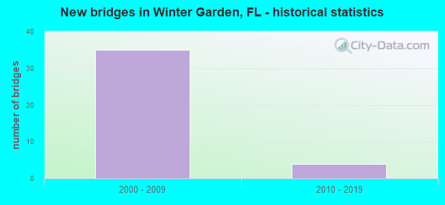
- New bridges - historical statistics
- 352000-2009
- 42010-2019


- Bridge Condition - Deck
- 28.6%Very good
- 71.4%Good

- Bridge Condition - Superstructure
- 71.4%Very good
- 28.6%Good

- Bridge Condition - Substructure
- 42.9%Very good
- 50.0%Good
- 7.1%Satisfactory
Find on map >> Show street view
Structure Number: 750406, Location: 0.5 Mi. North of SR-50 (Lat: 28.558667, Lng: -81.559889), Route carried "on" structure: State highway 429, Year Built: 2000, Status: Open, Structure Length: 3.50m (11.48ft), Average Daily Traffic: 36,750 (year 2020), Truck Traffic: 11%, Average Future Daily Traffic: 63,761 (year 2042), Design Load: HS 20, Features Intersected: Story Road & Access Rd.
Minimum Vertical Clearance: 30+ m (98+ ft), Kilometerpoint: 48.660, Lanes on structure: 3, Lanes under structure: 4, Base Highway Network: Yes, Toll: On toll road, Owner: State Toll Authority, Approaching Roadway Width: 16.8m (55.1ft), Material/Design: Prestressed concrete, Design/Construction: Stringer/Multi-beam, Number Of Spans In Main Unit: 1, Length of Maximum Span: 34.4m (112.9ft), Curb-To-Curb Width: 17.1m (56.1ft), Out-to-Out Width: 18.0m (59.1ft)
Condition: Deck: Good, Superstructure: Very good, Substructure: Good, Inventory Rating: 60.8 metric tons, Method Used To Determine Inventory Rating: Load Factor (LF), Structural Evaluation: Better than present minimum criteria, Deck Geometry: Equal to present minimum criteria, Underclear: Meets minimum limits, Approach Roadway Alignment: Equal to present desirable criteria, Designated Inspection Frequency: Every 24 months, Inspection Date: August 2020, Deck Structure Type: Concrete Cast-file-Place
Find on map >> Show street view
Structure Number: 750407, Location: 0.5 Mi. North of SR-50 (Lat: 28.558667, Lng: -81.559556), Route carried "on" structure: State highway 429, Year Built: 2000, Status: Open, Structure Length: 3.50m (11.48ft), Average Daily Traffic: 36,750 (year 2020), Truck Traffic: 11%, Average Future Daily Traffic: 63,761 (year 2042), Design Load: HS 20, Features Intersected: Story Road & Access Rd.
Minimum Vertical Clearance: 30+ m (98+ ft), Kilometerpoint: 48.657, Lanes on structure: 4, Lanes under structure: 4, Base Highway Network: Yes, Toll: On toll road, Owner: State Toll Authority, Approaching Roadway Width: 23.2m (76.1ft), Material/Design: Prestressed concrete, Design/Construction: Stringer/Multi-beam, Number Of Spans In Main Unit: 1, Length of Maximum Span: 34.4m (112.9ft), Curb-To-Curb Width: 23.4m (76.8ft), Out-to-Out Width: 24.4m (80.1ft)
Condition: Deck: Good, Superstructure: Very good, Substructure: Good, Inventory Rating: 61.7 metric tons, Method Used To Determine Inventory Rating: Load Factor (LF), Structural Evaluation: Better than present minimum criteria, Deck Geometry: Superior to present desirable criteria, Underclear: Meets minimum limits, Approach Roadway Alignment: Equal to present desirable criteria, Designated Inspection Frequency: Every 24 months, Inspection Date: August 2020, Deck Structure Type: Concrete Cast-file-Place
Find on map >> Show street view
Structure Number: 750408, Location: 0.5 Mi. North of SR-50 (Lat: 28.558667, Lng: -81.560047), Route carried "on" structure: Ramp State highway 429, Year Built: 2000, Status: Open, Structure Length: 3.51m (11.52ft), Average Daily Traffic: 4,300 (year 2020), Truck Traffic: 6%, Average Future Daily Traffic: 7,460 (year 2042), Design Load: HS 20, Features Intersected: Story Road & Access Rd.
Minimum Vertical Clearance: 30+ m (98+ ft), Kilometerpoint: 0.180, Lanes on structure: 1, Lanes under structure: 4, Toll: On toll road, Owner: State Toll Authority, Approaching Roadway Width: 6.4m (21.0ft), Material/Design: Prestressed concrete, Design/Construction: Stringer/Multi-beam, Number Of Spans In Main Unit: 1, Length of Maximum Span: 34.5m (113.2ft), Curb-To-Curb Width: 8.2m (26.9ft), Out-to-Out Width: 9.2m (30.2ft)
Condition: Deck: Good, Superstructure: Very good, Substructure: Good, Inventory Rating: 56.2 metric tons, Method Used To Determine Inventory Rating: Load Factor (LF), Structural Evaluation: Better than present minimum criteria, Deck Geometry: Superior to present desirable criteria, Underclear: Meets minimum limits, Approach Roadway Alignment: Equal to present desirable criteria, Designated Inspection Frequency: Every 24 months, Inspection Date: August 2020, Deck Structure Type: Concrete Cast-file-Place
Find on map >> Show street view
Structure Number: 750535, Location: 4.3 Mi. South of Turnpike (Lat: 28.512028, Lng: -81.605528), Route carried "on" structure: State highway 429, Year Built: 2005, Status: Open, Structure Length: 2.88m (9.45ft), Average Daily Traffic: 23,500 (year 2020), Truck Traffic: 4%, Average Future Daily Traffic: 40,772 (year 2042), Design Load: HS 20+Mod, Features Intersected: Stoneybrook West Pkwy.
Minimum Vertical Clearance: 30+ m (98+ ft), Kilometerpoint: 40.496, Lanes on structure: 2, Lanes under structure: 2, Base Highway Network: Yes, Toll: On toll road, Owner: State Toll Authority, Approaching Roadway Width: 12.2m (40.0ft), Skew: 3 degrees, Material/Design: Prestressed concrete, Design/Construction: Stringer/Multi-beam, Number Of Spans In Main Unit: 1, Length of Maximum Span: 28.2m (92.5ft), Curb-To-Curb Width: 12.2m (40.0ft), Out-to-Out Width: 13.1m (43.0ft)
Condition: Deck: Very good, Superstructure: Very good, Substructure: Very good, Inventory Rating: 55.8 metric tons, Method Used To Determine Inventory Rating: Load Factor (LF), Structural Evaluation: Equal to present desirable criteria, Deck Geometry: Better than present minimum criteria, Underclear: Superior to present desirable criteria, Approach Roadway Alignment: Better than present minimum criteria, Designated Inspection Frequency: Every 24 months, Inspection Date: May 2020, Deck Structure Type: Concrete Cast-file-Place
Find on map >> Show street view
Structure Number: 750536, Location: 4.3 Mi. South of Turnpike (Lat: 28.511944, Lng: -81.605194), Route carried "on" structure: State highway 429, Year Built: 2005, Status: Open, Structure Length: 2.91m (9.55ft), Average Daily Traffic: 23,500 (year 2020), Truck Traffic: 4%, Average Future Daily Traffic: 40,772 (year 2042), Design Load: HS 20+Mod, Features Intersected: Stoneybrook West Pkwy.
Minimum Vertical Clearance: 30+ m (98+ ft), Kilometerpoint: 40.518, Lanes on structure: 2, Lanes under structure: 2, Base Highway Network: Yes, Toll: On toll road, Owner: State Toll Authority, Approaching Roadway Width: 12.2m (40.0ft), Skew: 3 degrees, Material/Design: Prestressed concrete, Design/Construction: Stringer/Multi-beam, Number Of Spans In Main Unit: 1, Length of Maximum Span: 28.5m (93.5ft), Curb-To-Curb Width: 12.2m (40.0ft), Out-to-Out Width: 13.1m (43.0ft)
Condition: Deck: Very good, Superstructure: Very good, Substructure: Good, Inventory Rating: 55.8 metric tons, Method Used To Determine Inventory Rating: Load Factor (LF), Structural Evaluation: Better than present minimum criteria, Deck Geometry: Better than present minimum criteria, Underclear: Superior to present desirable criteria, Approach Roadway Alignment: Better than present minimum criteria, Designated Inspection Frequency: Every 24 months, Inspection Date: May 2020, Deck Structure Type: Concrete Cast-file-Place
Find on map >> Show street view
Structure Number: 750537, Location: 3 Mi. South of Turnpike (Lat: 28.517778, Lng: -81.586028), Route carried "on" structure: State highway 429, Year Built: 2005, Status: Open, Structure Length: 5.02m (16.47ft), Average Daily Traffic: 23,500 (year 2020), Truck Traffic: 4%, Average Future Daily Traffic: 40,772 (year 2042), Design Load: HS 20+Mod, Features Intersected: CR-535
Minimum Vertical Clearance: 30+ m (98+ ft), Kilometerpoint: 42.532, Lanes on structure: 2, Lanes under structure: 9, Base Highway Network: Yes, Toll: On toll road, Owner: State Toll Authority, Approaching Roadway Width: 12.2m (40.0ft), Skew: 1 degrees, Material/Design: Prestressed concrete, Design/Construction: Stringer/Multi-beam, Number Of Spans In Main Unit: 1, Length of Maximum Span: 49.6m (162.7ft), Curb-To-Curb Width: 12.2m (40.0ft), Out-to-Out Width: 13.1m (43.0ft)
Condition: Deck: Very good, Superstructure: Very good, Substructure: Very good, Inventory Rating: 72.6 metric tons, Method Used To Determine Inventory Rating: Load Factor (LF), Structural Evaluation: Equal to present desirable criteria, Deck Geometry: Better than present minimum criteria, Underclear: Equal to present minimum criteria, Approach Roadway Alignment: Better than present minimum criteria, Designated Inspection Frequency: Every 24 months, Inspection Date: May 2020, Deck Structure Type: Concrete Cast-file-Place
Find on map >> Show street view
Structure Number: 750538, Location: 3 Mi. South of Turnpike (Lat: 28.517556, Lng: -81.585903), Route carried "on" structure: State highway 429, Year Built: 2005, Status: Open, Structure Length: 5.02m (16.47ft), Average Daily Traffic: 23,500 (year 2020), Truck Traffic: 4%, Average Future Daily Traffic: 40,772 (year 2042), Design Load: HS 20+Mod, Features Intersected: CR-535
Minimum Vertical Clearance: 30+ m (98+ ft), Kilometerpoint: 42.532, Lanes on structure: 2, Lanes under structure: 9, Base Highway Network: Yes, Toll: On toll road, Owner: State Toll Authority, Approaching Roadway Width: 12.2m (40.0ft), Skew: 1 degrees, Material/Design: Prestressed concrete, Design/Construction: Stringer/Multi-beam, Number Of Spans In Main Unit: 1, Length of Maximum Span: 49.6m (162.7ft), Curb-To-Curb Width: 12.2m (40.0ft), Out-to-Out Width: 13.1m (43.0ft)
Condition: Deck: Very good, Superstructure: Very good, Substructure: Very good, Inventory Rating: 72.6 metric tons, Method Used To Determine Inventory Rating: Load Factor (LF), Structural Evaluation: Equal to present desirable criteria, Deck Geometry: Better than present minimum criteria, Underclear: Equal to present minimum criteria, Approach Roadway Alignment: Better than present minimum criteria, Designated Inspection Frequency: Every 24 months, Inspection Date: May 2020, Deck Structure Type: Concrete Cast-file-Place
Find on map >> Show street view
Structure Number: 750549, Location: SR-429-SR-50 (Lat: 28.551417, Lng: -81.558853), Route carried "on" structure: State highway 429, Year Built: 2002, Status: Open, Structure Length: 5.45m (17.88ft), Average Daily Traffic: 25,500 (year 2020), Truck Traffic: 7%, Average Future Daily Traffic: 44,242 (year 2042), Design Load: HS 20, Features Intersected: SR-50
Minimum Vertical Clearance: 30+ m (98+ ft), Kilometerpoint: 47.851, Lanes on structure: 2, Lanes under structure: 6, Base Highway Network: Yes, Toll: On toll road, Owner: State Toll Authority, Approaching Roadway Width: 12.2m (40.0ft), Material/Design: Steel, Design/Construction: Stringer/Multi-beam, Number Of Spans In Main Unit: 1, Length of Maximum Span: 53.9m (176.8ft), Curb-To-Curb Width: 12.2m (40.0ft), Out-to-Out Width: 13.1m (43.0ft)
Condition: Deck: Good, Superstructure: Very good, Substructure: Very good, Operating Rating: 56.7 metric tons, Method Used To Determine Operating Rating: Load Factor (LF), Inventory Rating: 34.0 metric tons, Method Used To Determine Inventory Rating: Load Factor (LF), Structural Evaluation: Equal to present desirable criteria, Deck Geometry: Better than present minimum criteria, Underclear: Superior to present desirable criteria, Approach Roadway Alignment: Equal to present desirable criteria, Designated Inspection Frequency: Every 24 months, Inspection Date: December 2020, Deck Structure Type: Concrete Cast-file-Place
Find on map >> Show street view
Structure Number: 75055, Location: SR-429-SR-50 (Lat: 28.551417, Lng: -81.558558), Route carried "on" structure: State highway 429, Year Built: 2002, Status: Open, Structure Length: 5.45m (17.88ft), Average Daily Traffic: 25,500 (year 2020), Truck Traffic: 7%, Average Future Daily Traffic: 44,242 (year 2042), Design Load: HS 20, Features Intersected: SR-50
Minimum Vertical Clearance: 30+ m (98+ ft), Kilometerpoint: 47.846, Lanes on structure: 2, Lanes under structure: 6, Base Highway Network: Yes, Toll: On toll road, Owner: State Toll Authority, Approaching Roadway Width: 12.2m (40.0ft), Material/Design: Steel, Design/Construction: Stringer/Multi-beam, Number Of Spans In Main Unit: 1, Length of Maximum Span: 53.9m (176.8ft), Curb-To-Curb Width: 12.2m (40.0ft), Out-to-Out Width: 13.1m (43.0ft)
Condition: Deck: Good, Superstructure: Very good, Substructure: Very good, Operating Rating: 56.7 metric tons, Method Used To Determine Operating Rating: Load Factor (LF), Inventory Rating: 34.0 metric tons, Method Used To Determine Inventory Rating: Load Factor (LF), Structural Evaluation: Equal to present desirable criteria, Deck Geometry: Better than present minimum criteria, Underclear: Equal to present minimum criteria, Approach Roadway Alignment: Equal to present desirable criteria, Designated Inspection Frequency: Every 24 months, Inspection Date: December 2020, Deck Structure Type: Concrete Cast-file-Place
Find on map >> Show street view
Structure Number: 750551, Location: 0.2 MI W OF SR 50 (Lat: 28.547928, Lng: -81.558342), Route carried "on" structure: Ramp State highway 91, Year Built: 2002, Status: Open, Structure Length: 61.45m (201.61ft), Average Daily Traffic: 9,400 (year 2020), Truck Traffic: 21%, Average Future Daily Traffic: 16,309 (year 2042), Design Load: HS 20, Features Intersected: SR 429/SR 91 TPK, Facility Carried by Structure: RAMP I 268.3
Minimum Vertical Clearance: 30+ m (98+ ft), Kilometerpoint: 0.068, Lanes on structure: 1, Lanes under structure: 18, Toll: On toll road, Owner: State Toll Authority, Approaching Roadway Width: 9.4m (30.8ft), Material/Design: Steel continuous, Design/Construction: Stringer/Multi-beam, Number Of Spans In Main Unit: 12, Length of Maximum Span: 62.1m (203.7ft), Curb-To-Curb Width: 9.4m (30.8ft), Out-to-Out Width: 10.1m (33.1ft)
Condition: Deck: Good, Superstructure: Good, Substructure: Good, Operating Rating: 59.1 metric tons, Method Used To Determine Operating Rating: Load Factor (LF), Inventory Rating: 35.6 metric tons, Method Used To Determine Inventory Rating: Load Factor (LF), Structural Evaluation: Better than present minimum criteria, Deck Geometry: Superior to present desirable criteria, Underclear: Equal to present minimum criteria, Approach Roadway Alignment: Better than present minimum criteria, Designated Inspection Frequency: Every 24 months, Inspection Date: January 2022, Deck Structure Type: Concrete Cast-file-Place
Find on map >> Show street view
Structure Number: 750605, Location: 1.5 MILES S OF SR 438 (Lat: 28.549589, Lng: -81.558933), Route carried "on" structure: Ramp State highway 429, Year Built: 2001, Status: Open, Structure Length: 5.21m (17.09ft), Average Daily Traffic: 10,500 (year 2020), Truck Traffic: 21%, Average Future Daily Traffic: 18,218 (year 2042), Design Load: HS 20, Features Intersected: RAMP M
Minimum Vertical Clearance: 30+ m (98+ ft), Kilometerpoint: 0.209, Lanes on structure: 2, Lanes under structure: 1, Toll: On toll road, Owner: State Toll Authority, Approaching Roadway Width: 14.2m (46.6ft), Skew: 7 degrees, Material/Design: Steel, Design/Construction: Stringer/Multi-beam, Number Of Spans In Main Unit: 1, Length of Maximum Span: 52.1m (170.9ft), Curb-To-Curb Width: 14.2m (46.6ft), Out-to-Out Width: 15.1m (49.5ft)
Condition: Deck: Good, Superstructure: Good, Substructure: Good, Operating Rating: 62.6 metric tons, Method Used To Determine Operating Rating: Load Factor (LF), Inventory Rating: 37.2 metric tons, Method Used To Determine Inventory Rating: Load Factor (LF), Structural Evaluation: Better than present minimum criteria, Deck Geometry: Superior to present desirable criteria, Underclear: Somewhat better than minimum adequacy, Approach Roadway Alignment: Equal to present desirable criteria, Designated Inspection Frequency: Every 24 months, Inspection Date: October 2021, Deck Structure Type: Concrete Cast-file-Place
Find on map >> Show street view
Structure Number: 750607, Location: SR 91 & SR 429 INTERCHNG (Lat: 28.547342, Lng: -81.559078), Route carried "on" structure: Ramp State highway 91, Year Built: 2001, Status: Open, Structure Length: 52.73m (173.00ft), Average Daily Traffic: 4,400 (year 2020), Truck Traffic: 21%, Average Future Daily Traffic: 7,634 (year 2042), Design Load: HS 20+Mod, Features Intersected: SR 91 TPK
Minimum Vertical Clearance: 30+ m (98+ ft), Kilometerpoint: 0.475, Lanes on structure: 1, Lanes under structure: 17, Toll: On toll road, Owner: State Toll Authority, Approaching Roadway Width: 9.4m (30.8ft), Skew: 9 degrees, Material/Design: Steel continuous, Design/Construction: Stringer/Multi-beam, Number Of Spans In Main Unit: 10, Length of Maximum Span: 59.7m (195.9ft), Curb-To-Curb Width: 10.1m (33.1ft), Out-to-Out Width: 11.0m (36.1ft)
Condition: Deck: Good, Superstructure: Good, Substructure: Satisfactory, Operating Rating: 57.7 metric tons, Method Used To Determine Operating Rating: Load Factor (LF), Inventory Rating: 34.7 metric tons, Method Used To Determine Inventory Rating: Load Factor (LF), Structural Evaluation: Equal to present minimum criteria, Deck Geometry: Superior to present desirable criteria, Underclear: Somewhat better than minimum adequacy, Approach Roadway Alignment: Better than present minimum criteria, Designated Inspection Frequency: Every 24 months, Inspection Date: January 2022, Deck Structure Type: Concrete Cast-file-Place
Find on map >> Show street view
Structure Number: 750634, Location: 9.2 MI N OF I-4 (Lat: 28.545267, Lng: -81.569956), Route carried "on" structure: State highway 91, Year Built: 2010, Status: Open, Structure Length: 2.40m (7.87ft), Average Daily Traffic: 94,000 (year 2020), Truck Traffic: 21%, Average Future Daily Traffic: 163,090 (year 2042), Design Load: HL 93, Features Intersected: BEULAH ROAD
Minimum Vertical Clearance: 30.45m (99.90ft), Kilometerpoint: 31.405, Lanes on structure: 8, Lanes under structure: 2, Base Highway Network: Yes, Toll: On toll road, Owner: State Toll Authority, Approaching Roadway Width: 42.7m (140.1ft), Skew: 30 degrees, Material/Design: Prestressed concrete, Design/Construction: Stringer/Multi-beam, Number Of Spans In Main Unit: 1, Length of Maximum Span: 24.0m (78.7ft), Curb-To-Curb Width: 42.7m (140.1ft), Out-to-Out Width: 44.2m (145.0ft)
Condition: Deck: Good, Superstructure: Good, Substructure: Good, Operating Rating: 41.2 metric tons, Method Used To Determine Operating Rating: Load and Resistance Factor (LRFR), Inventory Rating: 37.2 metric tons, Method Used To Determine Inventory Rating: Load and Resistance Factor (LRFR), Structural Evaluation: Better than present minimum criteria, Deck Geometry: Superior to present desirable criteria, Underclear: Superior to present desirable criteria, Approach Roadway Alignment: Equal to present desirable criteria, Designated Inspection Frequency: Every 24 months, Inspection Date: November 2021, Deck Structure Type: Concrete Cast-file-Place
Find on map >> Show street view
Structure Number: 750635, Location: 0.4 MI S OF SR 50 (Lat: 28.545178, Lng: -81.587706), Route carried "on" structure: County highway 535, Year Built: 2010, Status: Open, Structure Length: 6.46m (21.19ft), Average Daily Traffic: 36,000 (year 2020), Truck Traffic: 6%, Average Future Daily Traffic: 62,460 (year 2042), Design Load: HL 93, Features Intersected: SR 91 TPK
Minimum Vertical Clearance: 30+ m (98+ ft), Kilometerpoint: 24.592, Lanes on structure: 2, Lanes under structure: 8, Owner: State Toll Authority, Approaching Roadway Width: 8.5m (27.9ft), Material/Design: Prestressed concrete, Design/Construction: Stringer/Multi-beam, Number Of Spans In Main Unit: 2, Length of Maximum Span: 32.3m (106.0ft), Curb or Sidewalk Widths: Left: 1.6m (5.2ft), Right: 1.6m (5.2ft), Curb-To-Curb Width: 8.5m (27.9ft), Out-to-Out Width: 12.9m (42.3ft)
Condition: Deck: Good, Superstructure: Very good, Substructure: Very good, Operating Rating: 46.5 metric tons, Method Used To Determine Operating Rating: Load and Resistance Factor (LRFR), Inventory Rating: 42.4 metric tons, Method Used To Determine Inventory Rating: Load and Resistance Factor (LRFR), Structural Evaluation: Equal to present desirable criteria, Deck Geometry: Meets minimum limits, Underclear: Equal to present minimum criteria, Approach Roadway Alignment: Equal to present desirable criteria, Designated Inspection Frequency: Every 24 months, Inspection Date: October 2021, Deck Structure Type: Concrete Cast-file-Place
Find on map >> Show street view
Structure Number: 750406, Location: 0.5 Mi. North of SR-50 (Lat: 28.558667, Lng: -81.559889), Route carried "under" structure: ServiceCity street , Year Built: 2000, Structure Length: 0. m, Average Daily Traffic: 101 (year 2020), Truck Traffic: 10%, Features Intersected: Story Road & Access Rd., Facility Carried by Structure: SR-429 SB
Minimum Vertical Clearance: 6.68m (21.92ft), Kilometerpoint: 0.000, Lanes on structure: 3, Lanes under structure: 2, Material/Design: Prestressed concrete, Design/Construction: Stringer/Multi-beam, Length of Maximum Span: 34.4m (112.9ft)
Find on map >> Show street view
Structure Number: 750406, Location: 0.5 Mi. North of SR-50 (Lat: 28.558667, Lng: -81.559889), Route carried "under" structure: City street , Year Built: 2000, Structure Length: 0. m, Average Daily Traffic: 4,500 (year 2020), Truck Traffic: 7%, Features Intersected: Story Road & Access Rd., Facility Carried by Structure: SR-429 SB
Minimum Vertical Clearance: 6.68m (21.92ft), Kilometerpoint: 4.305, Lanes on structure: 3, Lanes under structure: 2, Material/Design: Prestressed concrete, Design/Construction: Stringer/Multi-beam, Length of Maximum Span: 34.4m (112.9ft)
Find on map >> Show street view
Structure Number: 750407, Location: 0.5 Mi. North of SR-50 (Lat: 28.558667, Lng: -81.559556), Route carried "under" structure: ServiceCity street , Year Built: 2000, Structure Length: 0. m, Average Daily Traffic: 4,700 (year 2020), Truck Traffic: 10%, Features Intersected: Story Road & Access Rd., Facility Carried by Structure: SR-429 NB
Minimum Vertical Clearance: 6.49m (21.29ft), Kilometerpoint: 0.000, Lanes on structure: 4, Lanes under structure: 2, Material/Design: Prestressed concrete, Design/Construction: Stringer/Multi-beam, Length of Maximum Span: 34.4m (112.9ft)
Find on map >> Show street view
Structure Number: 750407, Location: 0.5 Mi. North of SR-50 (Lat: 28.558667, Lng: -81.559556), Route carried "under" structure: City street , Year Built: 2000, Structure Length: 0. m, Average Daily Traffic: 4,500 (year 2020), Truck Traffic: 7%, Features Intersected: Story Road & Access Rd., Facility Carried by Structure: SR-429 NB
Minimum Vertical Clearance: 6.49m (21.29ft), Kilometerpoint: 4.332, Lanes on structure: 4, Lanes under structure: 2, Material/Design: Prestressed concrete, Design/Construction: Stringer/Multi-beam, Length of Maximum Span: 34.4m (112.9ft)
Find on map >> Show street view
Structure Number: 750408, Location: 0.5 Mi. North of SR-50 (Lat: 28.558667, Lng: -81.560047), Route carried "under" structure: ServiceCity street , Year Built: 2000, Structure Length: 0. m, Average Daily Traffic: 101 (year 2020), Truck Traffic: 10%, Features Intersected: Story Road & Access Rd., Facility Carried by Structure: SR-429 Ramp L
Minimum Vertical Clearance: 7.19m (23.59ft), Kilometerpoint: 0.000, Lanes on structure: 1, Lanes under structure: 2, Material/Design: Prestressed concrete, Design/Construction: Stringer/Multi-beam, Length of Maximum Span: 34.5m (113.2ft)
Find on map >> Show street view
Structure Number: 750408, Location: 0.5 Mi. North of SR-50 (Lat: 28.558667, Lng: -81.560047), Route carried "under" structure: City street , Year Built: 2000, Structure Length: 0. m, Average Daily Traffic: 4,700 (year 2019), Truck Traffic: 6%, Features Intersected: Story Road & Access Rd., Facility Carried by Structure: SR-429 Ramp L
Minimum Vertical Clearance: 7.86m (25.79ft), Kilometerpoint: 0.000, Lanes on structure: 1, Lanes under structure: 2, Material/Design: Prestressed concrete, Design/Construction: Stringer/Multi-beam, Length of Maximum Span: 34.5m (113.2ft)
Find on map >> Show street view
Structure Number: 750535, Location: 4.3 Mi. South of Turnpike (Lat: 28.512028, Lng: -81.605528), Route carried "under" structure: County highway , Year Built: 2005, Structure Length: 0. m, Average Daily Traffic: 5,500 (year 2020), Truck Traffic: 6%, Features Intersected: Stoneybrook West Pkwy., Facility Carried by Structure: SR-429 SB
Minimum Vertical Clearance: 5.91m (19.39ft), Kilometerpoint: 1.579, Lanes on structure: 2, Lanes under structure: 2, Material/Design: Prestressed concrete, Design/Construction: Stringer/Multi-beam, Length of Maximum Span: 28.2m (92.5ft)
Find on map >> Show street view
Structure Number: 750536, Location: 4.3 Mi. South of Turnpike (Lat: 28.511944, Lng: -81.605194), Route carried "under" structure: County highway , Year Built: 2005, Structure Length: 0. m, Average Daily Traffic: 5,500 (year 2020), Truck Traffic: 6%, Features Intersected: Stoneybrook West Pkwy., Facility Carried by Structure: SR-429 NB
Minimum Vertical Clearance: 5.46m (17.91ft), Kilometerpoint: 1.614, Lanes on structure: 2, Lanes under structure: 2, Material/Design: Prestressed concrete, Design/Construction: Stringer/Multi-beam, Length of Maximum Span: 28.5m (93.5ft)
Find on map >> Show street view
Structure Number: 750537, Location: 3 Mi. South of Turnpike (Lat: 28.517778, Lng: -81.586028), Route carried "under" structure: County highway 535, Year Built: 2005, Structure Length: 0. m, Average Daily Traffic: 36,000 (year 2020), Truck Traffic: 6%, Features Intersected: CR-535, Facility Carried by Structure: SR-429 SB
Minimum Vertical Clearance: 5.18m (16.99ft), Kilometerpoint: 21.173, Lanes on structure: 2, Lanes under structure: 9, Material/Design: Prestressed concrete, Design/Construction: Stringer/Multi-beam, Length of Maximum Span: 49.6m (162.7ft)
Find on map >> Show street view
Structure Number: 750538, Location: 3 Mi. South of Turnpike (Lat: 28.517556, Lng: -81.585903), Route carried "under" structure: State highway 535, Year Built: 2005, Structure Length: 0. m, Average Daily Traffic: 36,000 (year 2020), Truck Traffic: 6%, Features Intersected: CR-535, Facility Carried by Structure: SR-429 NB
Minimum Vertical Clearance: 5.52m (18.11ft), Kilometerpoint: 21.142, Lanes on structure: 2, Lanes under structure: 9, Material/Design: Prestressed concrete, Design/Construction: Stringer/Multi-beam, Length of Maximum Span: 49.6m (162.7ft)
Find on map >> Show street view
Structure Number: 750549, Location: SR-429-SR-50 (Lat: 28.551417, Lng: -81.558853), Route carried "under" structure: State highway 50, Year Built: 2002, Structure Length: 0. m, Average Daily Traffic: 51,500 (year 2020), Truck Traffic: 5%, Features Intersected: SR-50, Facility Carried by Structure: SR-429 SB
Minimum Vertical Clearance: 5.61m (18.41ft), Kilometerpoint: 9.740, Lanes on structure: 2, Lanes under structure: 6, Material/Design: Steel, Design/Construction: Stringer/Multi-beam, Length of Maximum Span: 53.9m (176.8ft)
Find on map >> Show street view
Structure Number: 75055, Location: SR-429-SR-50 (Lat: 28.551417, Lng: -81.558558), Route carried "under" structure: State highway 50, Year Built: 2002, Structure Length: 0. m, Average Daily Traffic: 51,000 (year 2020), Truck Traffic: 5%, Features Intersected: SR-50, Facility Carried by Structure: SR-429 NB
Minimum Vertical Clearance: 5.64m (18.50ft), Kilometerpoint: 9.769, Lanes on structure: 2, Lanes under structure: 6, Material/Design: Steel, Design/Construction: Stringer/Multi-beam, Length of Maximum Span: 53.9m (176.8ft)
Find on map >> Show street view
Structure Number: 750551, Location: 0.2 MI W OF SR 50 (Lat: 28.547928, Lng: -81.558342), Route carried "under" structure: State highway 91, Year Built: 2002, Structure Length: 0. m, Average Daily Traffic: 76,100 (year 2020), Truck Traffic: 21%, Features Intersected: SR 429/SR 91 TPK, Facility Carried by Structure: RAMP I 268.3
Minimum Vertical Clearance: 19.39m (63.62ft), Kilometerpoint: 30.293, Lanes on structure: 1, Lanes under structure: 9, Toll: On toll road, Material/Design: Steel continuous, Design/Construction: Stringer/Multi-beam, Length of Maximum Span: 62.1m (203.7ft)
Find on map >> Show street view
Structure Number: 750551, Location: 0.2 MI W OF SR 50 (Lat: 28.547928, Lng: -81.558342), Route carried "under" structure: Ramp State highway 429, Year Built: 2002, Structure Length: 0. m, Average Daily Traffic: 1,800 (year 2016), Truck Traffic: 17%, Features Intersected: SR 429/SR 91 TPK, Facility Carried by Structure: RAMP I 268.3
Minimum Vertical Clearance: 20.57m (67.49ft), Kilometerpoint: 0.325, Lanes on structure: 1, Lanes under structure: 1, Toll: On toll road, Material/Design: Steel continuous, Design/Construction: Stringer/Multi-beam, Length of Maximum Span: 62.1m (203.7ft)
Find on map >> Show street view
Structure Number: 750551, Location: 0.2 MI W OF SR 50 (Lat: 28.547928, Lng: -81.558342), Route carried "under" structure: State highway 429, Year Built: 2002, Structure Length: 0. m, Average Daily Traffic: 73,600 (year 2016), Truck Traffic: 17%, Features Intersected: SR 429/SR 91 TPK, Facility Carried by Structure: RAMP I 268.3
Minimum Vertical Clearance: 11.33m (37.17ft), Kilometerpoint: 30.325, Lanes on structure: 1, Lanes under structure: 6, Toll: On toll road, Material/Design: Steel continuous, Design/Construction: Stringer/Multi-beam, Length of Maximum Span: 62.1m (203.7ft)
Find on map >> Show street view
Structure Number: 750551, Location: 0.2 MI W OF SR 50 (Lat: 28.547928, Lng: -81.558342), Route carried "under" structure: Ramp State highway 91, Year Built: 2002, Structure Length: 0. m, Average Daily Traffic: 10,500 (year 2020), Truck Traffic: 21%, Features Intersected: SR 429/SR 91 TPK, Facility Carried by Structure: RAMP I 268.3
Minimum Vertical Clearance: 5.27m (17.29ft), Kilometerpoint: 0.563, Lanes on structure: 1, Lanes under structure: 2, Toll: On toll road, Material/Design: Steel continuous, Design/Construction: Stringer/Multi-beam, Length of Maximum Span: 62.1m (203.7ft)
Find on map >> Show street view
Structure Number: 750605, Location: 1.5 MILES S OF SR 438 (Lat: 28.549589, Lng: -81.558933), Route carried "under" structure: Ramp State highway 429, Year Built: 2001, Structure Length: 0. m, Average Daily Traffic: 10,500 (year 2020), Truck Traffic: 21%, Features Intersected: RAMP M
Minimum Vertical Clearance: 4.90m (16.08ft), Kilometerpoint: 0.209, Lanes on structure: 2, Lanes under structure: 1, Toll: On toll road, Material/Design: Steel, Design/Construction: Stringer/Multi-beam, Length of Maximum Span: 52.1m (170.9ft)
Find on map >> Show street view
Structure Number: 750607, Location: SR 91 & SR 429 INTERCHNG (Lat: 28.547342, Lng: -81.559078), Route carried "under" structure: State highway 429, Year Built: 2001, Structure Length: 0. m, Average Daily Traffic: 73,600 (year 2016), Truck Traffic: 6%, Features Intersected: SR 91 TPK, Facility Carried by Structure: RAMP SR 91 268.3
Minimum Vertical Clearance: 8.05m (26.41ft), Kilometerpoint: 30.325, Lanes on structure: 1, Lanes under structure: 4, Toll: On toll road, Material/Design: Steel continuous, Design/Construction: Stringer/Multi-beam, Length of Maximum Span: 59.7m (195.9ft)
Find on map >> Show street view
Structure Number: 750607, Location: SR 91 & SR 429 INTERCHNG (Lat: 28.547342, Lng: -81.559078), Route carried "under" structure: Ramp State highway 91, Year Built: 2001, Structure Length: 0. m, Average Daily Traffic: 10,500 (year 2020), Truck Traffic: 21%, Features Intersected: SR 91 TPK
Minimum Vertical Clearance: 4.95m (16.24ft), Kilometerpoint: 0.515, Lanes on structure: 1, Lanes under structure: 2, Toll: On toll road, Material/Design: Steel continuous, Design/Construction: Stringer/Multi-beam, Length of Maximum Span: 59.7m (195.9ft)
Find on map >> Show street view
Structure Number: 750607, Location: SR 91 & SR 429 INTERCHNG (Lat: 28.547342, Lng: -81.559078), Route carried "under" structure: Ramp State highway 91, Year Built: 2001, Structure Length: 0. m, Average Daily Traffic: 1,800 (year 2016), Truck Traffic: 17%, Features Intersected: SR 91 TPK
Minimum Vertical Clearance: 20.57m (67.49ft), Kilometerpoint: 0.370, Lanes on structure: 1, Lanes under structure: 1, Toll: On toll road, Material/Design: Steel continuous, Design/Construction: Stringer/Multi-beam, Length of Maximum Span: 59.7m (195.9ft)
Find on map >> Show street view
Structure Number: 750607, Location: SR 91 & SR 429 INTERCHNG (Lat: 28.547342, Lng: -81.559078), Route carried "under" structure: Ramp State highway 429, Year Built: 2001, Structure Length: 0. m, Average Daily Traffic: 3,300 (year 2020), Truck Traffic: 6%, Features Intersected: SR 91 TPK, Facility Carried by Structure: RAMP SR 91 268.3
Minimum Vertical Clearance: 4.94m (16.21ft), Kilometerpoint: 0.209, Lanes on structure: 1, Lanes under structure: 1, Toll: On toll road, Material/Design: Steel continuous, Design/Construction: Stringer/Multi-beam, Length of Maximum Span: 59.7m (195.9ft)
Find on map >> Show street view
Structure Number: 750607, Location: SR 91 & SR 429 INTERCHNG (Lat: 28.547342, Lng: -81.559078), Route carried "under" structure: Ramp State highway 429, Year Built: 2001, Structure Length: 0. m, Average Daily Traffic: 3,100 (year 2020), Truck Traffic: 6%, Features Intersected: SR 91 TPK, Facility Carried by Structure: RAMP SR 91 268.3
Minimum Vertical Clearance: 4.94m (16.21ft), Kilometerpoint: 0.241, Lanes on structure: 1, Lanes under structure: 1, Toll: On toll road, Material/Design: Steel continuous, Design/Construction: Stringer/Multi-beam, Length of Maximum Span: 59.7m (195.9ft)
Find on map >> Show street view
Structure Number: 750607, Location: SR 91 & SR 429 INTERCHNG (Lat: 28.547342, Lng: -81.559078), Route carried "under" structure: State highway 91, Year Built: 2001, Structure Length: 0. m, Average Daily Traffic: 76,100 (year 2020), Truck Traffic: 21%, Features Intersected: SR 91 TPK
Minimum Vertical Clearance: 16.54m (54.27ft), Kilometerpoint: 30.383, Lanes on structure: 1, Lanes under structure: 8, Toll: On toll road, Material/Design: Steel continuous, Design/Construction: Stringer/Multi-beam, Length of Maximum Span: 59.7m (195.9ft)
Find on map >> Show street view
Structure Number: 750634, Location: 9.2 MI N OF I-4 (Lat: 28.545267, Lng: -81.569956), Route carried "under" structure: County highway , Year Built: 2010, Structure Length: 0. m, Average Daily Traffic: 6,100 (year 2020), Truck Traffic: 6%, Features Intersected: BEULAH ROAD, Facility Carried by Structure: SR 91 TPK NS 269.1
Minimum Vertical Clearance: 5.03m (16.50ft), Kilometerpoint: 0.031, Lanes on structure: 8, Lanes under structure: 2, Material/Design: Prestressed concrete, Design/Construction: Stringer/Multi-beam, Length of Maximum Span: 24.0m (78.7ft)
Find on map >> Show street view
Structure Number: 750635, Location: 0.4 MI S OF SR 50 (Lat: 28.545178, Lng: -81.587706), Route carried "under" structure: State highway 91, Year Built: 2010, Structure Length: 0. m, Average Daily Traffic: 94,000 (year 2020), Truck Traffic: 21%, Features Intersected: SR 91 TPK, Facility Carried by Structure: CR 535 270.0
Minimum Vertical Clearance: 5.21m (17.09ft), Kilometerpoint: 33.144, Lanes on structure: 2, Lanes under structure: 8, Toll: On toll road, Material/Design: Prestressed concrete, Design/Construction: Stringer/Multi-beam, Length of Maximum Span: 32.3m (106.0ft)