Bridge Statistics for Winooski, Vermont (VT)
Condition, Traffic, Stress, Structural Evaluation, Project Costs
- National Bridge Inventory (NBI) Statistics
- 10Number of bridges
- 95ft / 28.9mTotal length
- $7,720,000Total costs
- 361,550Total average daily traffic
- 29,169Total average daily truck traffic
- National Bridge Inventory (NBI) Registered Bridges for Winooski
- No street view available for this location
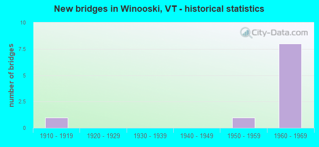
- New bridges - historical statistics
- 11910-1919
- 11950-1959
- 81960-1969


- Bridge Condition - Deck
- 71.4%Good
- 14.3%Satisfactory
- 14.3%Fair

- Bridge Condition - Superstructure
- 14.3%Very good
- 71.4%Good
- 14.3%Satisfactory

- Bridge Condition - Substructure
- 71.4%Good
- 28.6%Satisfactory
Find on map >> Show street view
Structure Number: 100418000104181, Location: 0.05 MI TO JCT W ALLEN ST (Lat: 44.492050, Lng: -73.188017), Route carried "on" structure: Other road C30WE, Year Built: 1916, Status: Posted for load, Structure Length: 1.71m (5.61ft), Average Daily Traffic: 750 (year 2019), Truck Traffic: 2%, Average Future Daily Traffic: 788 (year 2029), Features Intersected: NEW ENGLAND CENTRAL RR
Minimum Vertical Clearance: 30+ m (98+ ft), Kilometerpoint: 0.000, Lanes on structure: 2, Owner: Town or Township Highway Agency, Approaching Roadway Width: 9.1m (29.9ft), Material/Design: Concrete, Design/Construction: Culvert, Number Of Spans In Main Unit: 1, Length of Maximum Span: 11.6m (38.1ft), Curb or Sidewalk Widths: Left: 2.4m (7.9ft), Right: 2.3m (7.5ft), Curb-To-Curb Width: 16.2m (53.1ft), Out-to-Out Width: 17.0m (55.8ft)
Condition: Culverts: Satisfactory, Operating Rating: 28.1 metric tons, Method Used To Determine Operating Rating: Field evaluation and documented engineering judgment, Inventory Rating: 16.3 metric tons, Method Used To Determine Inventory Rating: Field evaluation and documented engineering judgment, Structural Evaluation: Meets minimum limits, Deck Geometry: Superior to present desirable criteria, Underclear: Meets minimum limits, Approach Roadway Alignment: Equal to present desirable criteria, Length Of Structure Improvement: 1.71m (5.61ft), Designated Inspection Frequency: Every 24 months, Inspection Date: September 2021, Bridge Improvement Cost: $1,092,000, Roadway Improvement Cost: $50,000, Total Project Cost: $1,142,000 ( Estimate for 2020), Deck Structure Type: Concrete Cast-file-Place
Find on map >> Show street view
Structure Number: 200089071N04182, Location: 0.2 MI S EXIT 15 (Lat: 44.490472, Lng: -73.172997), Route carried "on" structure: Interstate 89, Year Built: 1962, Status: Open, Structure Length: 4.33m (14.21ft), Average Daily Traffic: 56,400 (year 2018), Truck Traffic: 8%, Average Future Daily Traffic: 59,220 (year 2028), Design Load: HS 20, Features Intersected: I 89 OVER NECRR
Minimum Vertical Clearance: 30+ m (98+ ft), Kilometerpoint: 145.277, Lanes on structure: 2, Base Highway Network: Yes, Owner: State Highway Agency, Approaching Roadway Width: 12.2m (40.0ft), Skew: 13 degrees, Material/Design: Steel, Design/Construction: Stringer/Multi-beam, Number Of Spans In Main Unit: 3, Length of Maximum Span: 15.8m (51.8ft), Curb or Sidewalk Widths: Left: 0.2m (0.7ft), Right: 0.2m (0.7ft), Curb-To-Curb Width: 12.8m (42.0ft), Out-to-Out Width: 14.3m (46.9ft)
Condition: Deck: Good, Superstructure: Good, Substructure: Good, Operating Rating: 69.9 metric tons, Method Used To Determine Operating Rating: Load Factor (LF), Inventory Rating: 41.7 metric tons, Method Used To Determine Inventory Rating: Load Factor (LF), Structural Evaluation: Better than present minimum criteria, Deck Geometry: Equal to present desirable criteria, Underclear: Equal to present minimum criteria, Approach Roadway Alignment: Equal to present desirable criteria, Designated Inspection Frequency: Every 24 months, Inspection Date: June 2020, Deck Structure Type: Concrete Cast-file-Place, Wearing Surface/Protective System: Wearing Surface: Bituminous, Membrane: Preformed Fabric
Find on map >> Show street view
Structure Number: 200089071S04182, Location: 0.2 MI S EXIT 15 (Lat: 44.490600, Lng: -73.173319), Route carried "on" structure: Interstate 89, Year Built: 1962, Status: Open, Structure Length: 4.33m (14.21ft), Average Daily Traffic: 56,400 (year 2018), Truck Traffic: 8%, Average Future Daily Traffic: 59,220 (year 2028), Design Load: Railroad, Features Intersected: I 89 OVER NECRR
Minimum Vertical Clearance: 30+ m (98+ ft), Kilometerpoint: 145.277, Lanes on structure: 3, Base Highway Network: Yes, Owner: State Highway Agency, Approaching Roadway Width: 2.4m (7.9ft), Skew: 13 degrees, Material/Design: Steel, Design/Construction: Stringer/Multi-beam, Number Of Spans In Main Unit: 3, Length of Maximum Span: 15.8m (51.8ft), Curb or Sidewalk Widths: Left: 0.2m (0.7ft), Right: 0.2m (0.7ft), Curb-To-Curb Width: 12.8m (42.0ft), Out-to-Out Width: 14.3m (46.9ft)
Condition: Deck: Good, Superstructure: Good, Substructure: Good, Operating Rating: 69.9 metric tons, Method Used To Determine Operating Rating: Load Factor (LF), Inventory Rating: 41.7 metric tons, Method Used To Determine Inventory Rating: Load Factor (LF), Structural Evaluation: Better than present minimum criteria, Deck Geometry: High priority of replacement, Underclear: Equal to present minimum criteria, Approach Roadway Alignment: Equal to present desirable criteria, Length Of Structure Improvement: 4.33m (14.21ft), Designated Inspection Frequency: Every 24 months, Inspection Date: June 2020, Bridge Improvement Cost: $2,336,000, Roadway Improvement Cost: $50,000, Total Project Cost: $2,386,000 ( Estimate for 2020), Deck Structure Type: Concrete Cast-file-Place, Wearing Surface/Protective System: Wearing Surface: Bituminous, Membrane: Preformed Fabric
Find on map >> Show street view
Structure Number: 200089072N04182, Location: I 89 EXIT 15 (Lat: 44.493239, Lng: -73.173144), Route carried "on" structure: Interstate 89, Year Built: 1962, Status: Open, Structure Length: 5.09m (16.70ft), Average Daily Traffic: 56,400 (year 2018), Truck Traffic: 8%, Average Future Daily Traffic: 59,220 (year 2028), Design Load: HS 20, Features Intersected: I 89 OVER VT 15
Minimum Vertical Clearance: 30+ m (98+ ft), Kilometerpoint: 145.582, Lanes on structure: 2, Lanes under structure: 2, Base Highway Network: Yes, Owner: State Highway Agency, Approaching Roadway Width: 11.6m (38.1ft), Skew: 10 degrees, Material/Design: Steel, Design/Construction: Stringer/Multi-beam, Number Of Spans In Main Unit: 3, Length of Maximum Span: 28.0m (91.9ft), Curb or Sidewalk Widths: Left: 0.2m (0.7ft), Right: 0.2m (0.7ft), Curb-To-Curb Width: 9.1m (29.9ft), Out-to-Out Width: 10.7m (35.1ft)
Condition: Deck: Fair, Superstructure: Good, Substructure: Satisfactory, Operating Rating: 62.6 metric tons, Method Used To Determine Operating Rating: Load Factor (LF), Inventory Rating: 37.2 metric tons, Method Used To Determine Inventory Rating: Load Factor (LF), Structural Evaluation: Equal to present minimum criteria, Deck Geometry: High priority of replacement, Underclear: Equal to present minimum criteria, Approach Roadway Alignment: Equal to present desirable criteria, Length Of Structure Improvement: 5.09m (16.70ft), Designated Inspection Frequency: Every 24 months, Inspection Date: June 2020, Bridge Improvement Cost: $2,046,000, Roadway Improvement Cost: $50,000, Total Project Cost: $2,096,000 ( Estimate for 2020), Deck Structure Type: Concrete Cast-file-Place, Wearing Surface/Protective System: Wearing Surface: Bituminous
Find on map >> Show street view
Structure Number: 200089072S04182, Location: I 89 EXIT 15 (Lat: 44.493233, Lng: -73.173419), Route carried "on" structure: Interstate 89, Year Built: 1962, Status: Open, Structure Length: 5.09m (16.70ft), Average Daily Traffic: 56,400 (year 2018), Truck Traffic: 8%, Average Future Daily Traffic: 59,220 (year 2028), Design Load: HS 20, Features Intersected: I 89 OVER VT 15
Minimum Vertical Clearance: 30+ m (98+ ft), Kilometerpoint: 145.582, Lanes on structure: 2, Lanes under structure: 2, Base Highway Network: Yes, Owner: State Highway Agency, Approaching Roadway Width: 11.6m (38.1ft), Skew: 10 degrees, Material/Design: Steel, Design/Construction: Stringer/Multi-beam, Number Of Spans In Main Unit: 3, Length of Maximum Span: 28.0m (91.9ft), Curb or Sidewalk Widths: Left: 0.2m (0.7ft), Right: 0.2m (0.7ft), Curb-To-Curb Width: 9.1m (29.9ft), Out-to-Out Width: 10.7m (35.1ft)
Condition: Deck: Good, Superstructure: Good, Substructure: Good, Operating Rating: 62.6 metric tons, Method Used To Determine Operating Rating: Load Factor (LF), Inventory Rating: 37.2 metric tons, Method Used To Determine Inventory Rating: Load Factor (LF), Structural Evaluation: Better than present minimum criteria, Deck Geometry: High priority of replacement, Underclear: Equal to present minimum criteria, Approach Roadway Alignment: Equal to present desirable criteria, Length Of Structure Improvement: 5.09m (16.70ft), Designated Inspection Frequency: Every 24 months, Inspection Date: June 2020, Bridge Improvement Cost: $2,046,000, Roadway Improvement Cost: $50,000, Total Project Cost: $2,096,000 ( Estimate for 2020), Deck Structure Type: Concrete Cast-file-Place, Wearing Surface/Protective System: Wearing Surface: Bituminous, Membrane: Preformed Fabric
Find on map >> Show street view
Structure Number: 200089073N04182, Location: 0.1 MI N EXIT 15 (Lat: 44.495253, Lng: -73.173272), Route carried "on" structure: Interstate 89, Year Built: 1962, Status: Open, Structure Length: 3.87m (12.70ft), Average Daily Traffic: 39,500 (year 2018), Truck Traffic: 8%, Average Future Daily Traffic: 41,475 (year 2028), Design Load: HS 20, Features Intersected: I 89 OVER LAFOUNTAIN
Minimum Vertical Clearance: 30+ m (98+ ft), Kilometerpoint: 145.791, Lanes on structure: 2, Lanes under structure: 2, Base Highway Network: Yes, Owner: State Highway Agency, Approaching Roadway Width: 11.6m (38.1ft), Skew: 10 degrees, Material/Design: Steel, Design/Construction: Stringer/Multi-beam, Number Of Spans In Main Unit: 3, Length of Maximum Span: 17.4m (57.1ft), Curb or Sidewalk Widths: Left: 0.2m (0.7ft), Right: 0.2m (0.7ft), Curb-To-Curb Width: 11.6m (38.1ft), Out-to-Out Width: 13.1m (43.0ft)
Condition: Deck: Good, Superstructure: Very good, Substructure: Satisfactory, Operating Rating: 67.1 metric tons, Method Used To Determine Operating Rating: Load Factor (LF), Inventory Rating: 39.9 metric tons, Method Used To Determine Inventory Rating: Load Factor (LF), Structural Evaluation: Equal to present minimum criteria, Deck Geometry: Equal to present minimum criteria, Underclear: Equal to present minimum criteria, Approach Roadway Alignment: Equal to present desirable criteria, Designated Inspection Frequency: Every 24 months, Inspection Date: June 2020, Deck Structure Type: Concrete Cast-file-Place, Wearing Surface/Protective System: Wearing Surface: Bituminous, Membrane: Preformed Fabric
Find on map >> Show street view
Structure Number: 200089073S04182, Location: 0.1 MI N EXIT 15 (Lat: 44.495244, Lng: -73.173572), Route carried "on" structure: Interstate 89, Year Built: 1962, Status: Open, Structure Length: 3.72m (12.20ft), Average Daily Traffic: 39,500 (year 2018), Truck Traffic: 8%, Average Future Daily Traffic: 41,475 (year 2028), Design Load: HS 20, Features Intersected: I 89 OVER LAFOUNTAIN
Minimum Vertical Clearance: 30+ m (98+ ft), Kilometerpoint: 145.791, Lanes on structure: 2, Lanes under structure: 2, Base Highway Network: Yes, Owner: State Highway Agency, Approaching Roadway Width: 11.6m (38.1ft), Skew: 10 degrees, Material/Design: Steel, Design/Construction: Stringer/Multi-beam, Number Of Spans In Main Unit: 3, Length of Maximum Span: 15.8m (51.8ft), Curb or Sidewalk Widths: Left: 0.2m (0.7ft), Right: 0.2m (0.7ft), Curb-To-Curb Width: 11.6m (38.1ft), Out-to-Out Width: 13.1m (43.0ft)
Condition: Deck: Good, Superstructure: Good, Substructure: Good, Operating Rating: 67.1 metric tons, Method Used To Determine Operating Rating: Load Factor (LF), Inventory Rating: 39.9 metric tons, Method Used To Determine Inventory Rating: Load Factor (LF), Structural Evaluation: Better than present minimum criteria, Deck Geometry: Equal to present minimum criteria, Underclear: Equal to present minimum criteria, Approach Roadway Alignment: Equal to present desirable criteria, Designated Inspection Frequency: Every 24 months, Inspection Date: June 2020, Deck Structure Type: Concrete Cast-file-Place, Wearing Surface/Protective System: Wearing Surface: Bituminous, Membrane: Preformed Fabric
Find on map >> Show street view
Structure Number: 205100015104182, Location: 0.1 MI N JCT. VT.15 (Lat: 44.492142, Lng: -73.186522), Route carried "on" structure: US 7, Year Built: 1952, Status: Open, Structure Length: 0.76m (2.49ft), Average Daily Traffic: 13,600 (year 2018), Truck Traffic: 7%, Average Future Daily Traffic: 14,280 (year 2028), Design Load: H 20, Features Intersected: US 7 OVER N.E.C. RR
Minimum Vertical Clearance: 30+ m (98+ ft), Kilometerpoint: 217.814, Lanes on structure: 2, Base Highway Network: Yes, Owner: City or Municipal Highway Agency, Maintenance Responsibility: State Highway Agency, Approaching Roadway Width: 14.6m (47.9ft), Material/Design: Concrete, Design/Construction: Slab, Number Of Spans In Main Unit: 1, Length of Maximum Span: 6.4m (21.0ft), Curb or Sidewalk Widths: Left: 1.5m (4.9ft), Right: 1.5m (4.9ft), Curb-To-Curb Width: 17.6m (57.7ft), Out-to-Out Width: 18.3m (60.0ft)
Condition: Deck: Satisfactory, Superstructure: Satisfactory, Substructure: Good, Operating Rating: 47.2 metric tons, Method Used To Determine Operating Rating: Load Factor (LF), Inventory Rating: 28.1 metric tons, Method Used To Determine Inventory Rating: Load Factor (LF), Structural Evaluation: Equal to present minimum criteria, Deck Geometry: Superior to present desirable criteria, Underclear: High priority of corrective action, Approach Roadway Alignment: Equal to present desirable criteria, Designated Inspection Frequency: Every 24 months, Inspection Date: May 2021, Deck Structure Type: Concrete Cast-file-Place, Wearing Surface/Protective System: Wearing Surface: Integral Concrete
Find on map >> Show street view
Structure Number: 200089072N04182, Location: I 89 EXIT 15 (Lat: 44.493239, Lng: -73.173144), Route carried "under" structure: State highway 15, Year Built: 1962, Structure Length: 0. m, Average Daily Traffic: 21,300 (year 1996), Truck Traffic: 9%, Features Intersected: I 89 OVER VT15, Facility Carried by Structure: I 00089 ML
Minimum Vertical Clearance: 4.80m (15.75ft), Kilometerpoint: 1.094, Lanes on structure: 2, Material/Design: Steel, Design/Construction: Stringer/Multi-beam, Length of Maximum Span: 28.0m (91.9ft)
Find on map >> Show street view
Structure Number: 200089072S04182, Location: I 89 EXIT 15 (Lat: 44.493233, Lng: -73.173419), Route carried "under" structure: State highway 15, Year Built: 1962, Structure Length: 0. m, Average Daily Traffic: 21,300 (year 1996), Truck Traffic: 9%, Features Intersected: I 89 OVER VT15, Facility Carried by Structure: I 00089 ML
Minimum Vertical Clearance: 4.67m (15.32ft), Kilometerpoint: 1.094, Lanes on structure: 2, Material/Design: Steel, Design/Construction: Stringer/Multi-beam, Length of Maximum Span: 28.0m (91.9ft)