Bridge Statistics for Winchester, Tennessee (TN)
Condition, Traffic, Stress, Structural Evaluation, Project Costs
- National Bridge Inventory (NBI) Statistics
- 37Number of bridges
- 463ft / 141mTotal length
- $14,388,000Total costs
- 168,880Total average daily traffic
- 13,417Total average daily truck traffic
- National Bridge Inventory (NBI) Registered Bridges for Winchester
- No street view available for this location
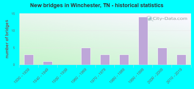
- New bridges - historical statistics
- 31930-1939
- 11940-1949
- 51960-1969
- 31970-1979
- 31980-1989
- 141990-1999
- 52000-2009
- 32010-2019
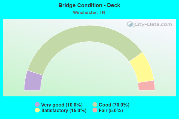
- Bridge Condition - Deck
- 10.0%Very good
- 70.0%Good
- 15.0%Satisfactory
- 5.0%Fair
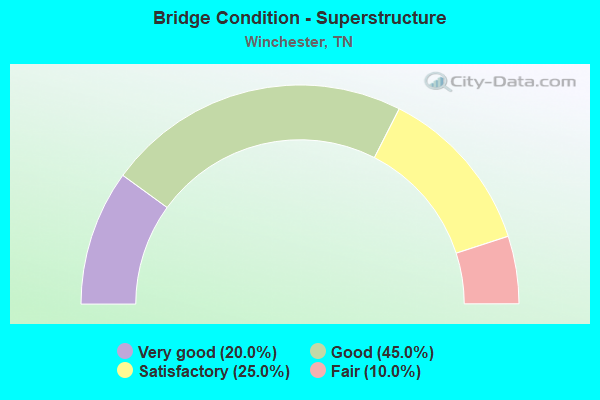
- Bridge Condition - Superstructure
- 20.0%Very good
- 45.0%Good
- 25.0%Satisfactory
- 10.0%Fair
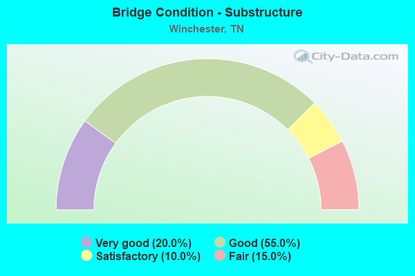
- Bridge Condition - Substructure
- 20.0%Very good
- 55.0%Good
- 10.0%Satisfactory
- 15.0%Fair
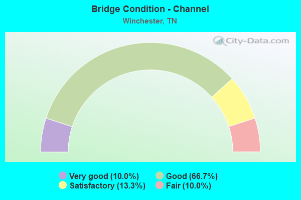
- Bridge Condition - Channel
- 10.0%Very good
- 66.7%Good
- 13.3%Satisfactory
- 10.0%Fair
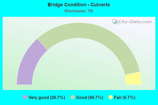
- Bridge Condition - Culverts
- 26.7%Very good
- 66.7%Good
- 6.7%Fair
Find on map >> Show street view
Structure Number: 26021060001, Location: 5.5 MI FROM SR15 (Lat: 35.142150, Lng: -86.065583), Route carried "on" structure: County highway 2106, Year Built: 1985, Status: Open, Structure Length: 1.52m (4.99ft), Average Daily Traffic: 664 (year 2020), Truck Traffic: 4%, Average Future Daily Traffic: 1,062 (year 2041), Design Load: HS 20, Features Intersected: NORWOOD CREEK
Minimum Vertical Clearance: 30+ m (98+ ft), Kilometerpoint: 6.743, Lanes on structure: 2, Owner: County Highway Agency, Approaching Roadway Width: 9.4m (30.8ft), Skew: 1 degrees, Material/Design: Concrete continuous, Design/Construction: Culvert, Number Of Spans In Main Unit: 3, Length of Maximum Span: 4.6m (15.1ft), Curb-To-Curb Width: 9.8m (32.2ft), Out-to-Out Width: 11.0m (36.1ft)
Condition: Channel: Satisfactory, Culverts: Good, Operating Rating: 71.3 metric tons, Method Used To Determine Operating Rating: Load Factor (LF), Inventory Rating: 32.4 metric tons, Method Used To Determine Inventory Rating: Load Factor (LF), Structural Evaluation: Better than present minimum criteria, Deck Geometry: Equal to present minimum criteria, Waterway Adequacy: Better than present minimum criteria, Approach Roadway Alignment: Equal to present minimum criteria, Designated Inspection Frequency: Every 24 months, Inspection Date: July 2021, Deck Structure Type: Concrete Cast-file-Place, Wearing Surface/Protective System: Wearing Surface: Bituminous
Find on map >> Show street view
Structure Number: 26021270001, Location: SOUTH OF US64 (Lat: 35.162450, Lng: -86.060417), Route carried "on" structure: County highway 2127, Year Built: 1960, Status: Open, Structure Length: 3.23m (10.60ft), Average Daily Traffic: 957 (year 2020), Truck Traffic: 3%, Average Future Daily Traffic: 1,531 (year 2041), Design Load: H 15, Features Intersected: BOILING FORK CREEK
Minimum Vertical Clearance: 30+ m (98+ ft), Kilometerpoint: 0.982, Lanes on structure: 2, Owner: County Highway Agency, Approaching Roadway Width: 7.0m (23.0ft), Material/Design: Prestressed concrete, Design/Construction: Box Beam or Girders - Multiple, Number Of Spans In Main Unit: 3, Length of Maximum Span: 13.7m (44.9ft), Curb-To-Curb Width: 6.9m (22.6ft), Out-to-Out Width: 7.4m (24.3ft)
Condition: Deck: Satisfactory, Superstructure: Satisfactory, Substructure: Fair, Channel: Fair, Operating Rating: 51.8 metric tons, Method Used To Determine Operating Rating: Load Factor (LF), Inventory Rating: 24.3 metric tons, Method Used To Determine Inventory Rating: Load Factor (LF), Structural Evaluation: Somewhat better than minimum adequacy, Deck Geometry: Meets minimum limits, Waterway Adequacy: Better than present minimum criteria, Approach Roadway Alignment: Equal to present minimum criteria, Length Of Structure Improvement: 3.23m (10.60ft), Designated Inspection Frequency: Every 24 months, Inspection Date: August 2021, Bridge Improvement Cost: $213,000, Roadway Improvement Cost: $22,000, Total Project Cost: $320,000 ( Estimate for 2021), Deck Structure Type: Other, Wearing Surface/Protective System: Wearing Surface: Bituminous
Find on map >> Show street view
Structure Number: 260A4060001, Location: .1 MI EAST OF SR16 (Lat: 35.201350, Lng: -86.091833), Route carried "on" structure: City street A406, Year Built: 1985, Status: Posted for load, Structure Length: 4.97m (16.31ft), Average Daily Traffic: 1,260 (year 2022), Truck Traffic: 2%, Average Future Daily Traffic: 2,016 (year 2041), Design Load: HS 20, Features Intersected: WAGNER CREEK
Minimum Vertical Clearance: 30+ m (98+ ft), Kilometerpoint: 0.417, Lanes on structure: 2, Owner: City or Municipal Highway Agency, Approaching Roadway Width: 9.1m (29.9ft), Skew: 6 degrees, Material/Design: Prestressed concrete continuous, Design/Construction: Stringer/Multi-beam, Number Of Spans In Main Unit: 3, Length of Maximum Span: 16.8m (55.1ft), Curb-To-Curb Width: 9.1m (29.9ft), Out-to-Out Width: 9.8m (32.2ft)
Condition: Deck: Good, Superstructure: Fair, Substructure: Good, Channel: Satisfactory, Operating Rating: 25.9 metric tons, Method Used To Determine Operating Rating: Load and Resistance Factor Rating (LRFR) rating reported by rating factor(RF) method using HL-93 loadings, Inventory Rating: 20.1 metric tons, Method Used To Determine Inventory Rating: Load and Resistance Factor Rating (LRFR) rating reported by rating factor(RF) method using HL-93 loadings, Structural Evaluation: Somewhat better than minimum adequacy, Deck Geometry: Somewhat better than minimum adequacy, Waterway Adequacy: Equal to present desirable criteria, Approach Roadway Alignment: Equal to present desirable criteria, Length Of Structure Improvement: 4.97m (16.31ft), Designated Inspection Frequency: Every 24 months, Inspection Date: August 2021, Bridge Improvement Cost: $860,000, Roadway Improvement Cost: $87,000, Total Project Cost: $1,291,000 ( Estimate for 2021), Deck Structure Type: Concrete Precast Panels, Wearing Surface/Protective System: Wearing Surface: Monolithic Concrete, Deck Protection: Epoxy Coated Reinforcing
Find on map >> Show street view
Structure Number: 260A5970001, Location: S OF WICHESTER AIRPORT (Lat: 35.152383, Lng: -86.063250), Route carried "on" structure: County highway 597, Year Built: 1998, Status: Open, Structure Length: 4.48m (14.70ft), Average Daily Traffic: 290 (year 2022), Truck Traffic: 2%, Average Future Daily Traffic: 464 (year 2041), Design Load: HS 20, Features Intersected: NORWOOD CREEK
Minimum Vertical Clearance: 30+ m (98+ ft), Kilometerpoint: 0.652, Lanes on structure: 2, Owner: County Highway Agency, Approaching Roadway Width: 6.7m (22.0ft), Skew: 2 degrees, Material/Design: Concrete continuous, Design/Construction: Culvert, Number Of Spans In Main Unit: 3, Length of Maximum Span: 12.7m (41.7ft), Curb-To-Curb Width: 6.7m (22.0ft), Out-to-Out Width: 8.3m (27.2ft)
Condition: Channel: Satisfactory, Culverts: Good, Operating Rating: 54.0 metric tons, Method Used To Determine Operating Rating: Load Factor (LF), Inventory Rating: 32.4 metric tons, Method Used To Determine Inventory Rating: Load Factor (LF), Structural Evaluation: Better than present minimum criteria, Deck Geometry: Meets minimum limits, Waterway Adequacy: Equal to present desirable criteria, Approach Roadway Alignment: Equal to present desirable criteria, Length Of Structure Improvement: 4.48m (14.70ft), Designated Inspection Frequency: Every 24 months, Inspection Date: August 2021, Bridge Improvement Cost: $128,000, Roadway Improvement Cost: $13,000, Total Project Cost: $193,000 ( Estimate for 2021), Deck Structure Type: Concrete Cast-file-Place, Wearing Surface/Protective System: Wearing Surface: Monolithic Concrete, Deck Protection: Epoxy Coated Reinforcing
Find on map >> Show street view
Structure Number: 260A6040003, Location: SOUTH OF SR15 (Lat: 35.124000, Lng: -86.062833), Route carried "on" structure: County highway 604, Year Built: 2017, Status: Open, Structure Length: 0.91m (2.99ft), Average Daily Traffic: 60 (year 2022), Truck Traffic: 2%, Average Future Daily Traffic: 96 (year 2039), Design Load: HL 93, Features Intersected: BRANCH
Minimum Vertical Clearance: 30+ m (98+ ft), Kilometerpoint: 1.516, Lanes on structure: 2, Owner: County Highway Agency, Approaching Roadway Width: 6.1m (20.0ft), Skew: 1 degrees, Material/Design: Prestressed concrete, Design/Construction: Box Beam or Girders - Single/Spread, Number Of Spans In Main Unit: 1, Length of Maximum Span: 9.1m (29.9ft), Curb-To-Curb Width: 7.9m (25.9ft), Out-to-Out Width: 8.9m (29.2ft)
Condition: Deck: Good, Superstructure: Very good, Substructure: Good, Channel: Good, Operating Rating: 44.1 metric tons, Method Used To Determine Operating Rating: Assigned ratings based on Load and Resistance Factor Design (LRFD) reported by rating factor (RF) using HL93 loadings, Inventory Rating: 32.4 metric tons, Method Used To Determine Inventory Rating: Assigned ratings based on Load and Resistance Factor Design (LRFD) reported by rating factor (RF) using HL93 loadings, Structural Evaluation: Better than present minimum criteria, Deck Geometry: Equal to present minimum criteria, Waterway Adequacy: Better than present minimum criteria, Approach Roadway Alignment: Equal to present desirable criteria, Designated Inspection Frequency: Every 24 months, Inspection Date: August 2021, Deck Structure Type: Concrete Cast-file-Place, Wearing Surface/Protective System: Wearing Surface: Monolithic Concrete, Deck Protection: Epoxy Coated Reinforcing
Find on map >> Show street view
Structure Number: 260A6090001, Location: EAST OF US64 (Lat: 35.122733, Lng: -86.111317), Route carried "on" structure: County highway 609, Year Built: 1983, Status: Open, Structure Length: 0.70m (2.30ft), Average Daily Traffic: 50 (year 2022), Truck Traffic: 2%, Average Future Daily Traffic: 80 (year 2041), Design Load: HS 20, Features Intersected: STEWART CREEK
Minimum Vertical Clearance: 30+ m (98+ ft), Kilometerpoint: 1.106, Lanes on structure: 2, Owner: County Highway Agency, Approaching Roadway Width: 5.8m (19.0ft), Material/Design: Concrete continuous, Design/Construction: Culvert, Number Of Spans In Main Unit: 2, Length of Maximum Span: 3.0m (9.8ft), Curb-To-Curb Width: 6.9m (22.6ft), Out-to-Out Width: 7.7m (25.3ft)
Condition: Channel: Good, Culverts: Good, Operating Rating: 89.1 metric tons, Method Used To Determine Operating Rating: Load Factor (LF), Inventory Rating: 32.4 metric tons, Method Used To Determine Inventory Rating: Load Factor (LF), Structural Evaluation: Better than present minimum criteria, Deck Geometry: Somewhat better than minimum adequacy, Waterway Adequacy: Better than present minimum criteria, Approach Roadway Alignment: Equal to present minimum criteria, Designated Inspection Frequency: Every 24 months, Inspection Date: August 2021, Deck Structure Type: Concrete Cast-file-Place, Wearing Surface/Protective System: Wearing Surface: Monolithic Concrete
Find on map >> Show street view
Structure Number: 260A6220001, Location: EAST OF US64 (Lat: 35.131433, Lng: -86.136050), Route carried "on" structure: County highway 622, Year Built: 1978, Status: Open, Structure Length: 0.88m (2.89ft), Average Daily Traffic: 280 (year 2022), Truck Traffic: 2%, Average Future Daily Traffic: 448 (year 2041), Design Load: H 15, Features Intersected: DRY CREEK
Minimum Vertical Clearance: 30+ m (98+ ft), Kilometerpoint: 0.565, Lanes on structure: 2, Owner: County Highway Agency, Approaching Roadway Width: 6.1m (20.0ft), Skew: 2 degrees, Material/Design: Steel, Design/Construction: Stringer/Multi-beam, Number Of Spans In Main Unit: 1, Length of Maximum Span: 8.8m (28.9ft), Curb-To-Curb Width: 8.5m (27.9ft), Out-to-Out Width: 8.5m (27.9ft)
Condition: Deck: Good, Superstructure: Satisfactory, Substructure: Good, Channel: Fair, Operating Rating: 44.1 metric tons, Method Used To Determine Operating Rating: Load Factor (LF), Inventory Rating: 24.3 metric tons, Method Used To Determine Inventory Rating: Load Factor (LF), Structural Evaluation: Equal to present minimum criteria, Deck Geometry: Equal to present minimum criteria, Waterway Adequacy: Equal to present minimum criteria, Approach Roadway Alignment: Equal to present minimum criteria, Length Of Structure Improvement: 0.88m (2.89ft), Designated Inspection Frequency: Every 24 months, Inspection Date: August 2021, Bridge Improvement Cost: $148,000, Roadway Improvement Cost: $15,000, Total Project Cost: $223,000 ( Estimate for 2021), Deck Structure Type: Concrete Cast-file-Place, Wearing Surface/Protective System: Wearing Surface: Bituminous
Find on map >> Show street view
Structure Number: 260A6220003, Location: NEAR BELVIDERE (Lat: 35.139533, Lng: -86.175050), Route carried "on" structure: County highway 622, Year Built: 2006, Status: Open, Structure Length: 0.79m (2.59ft), Average Daily Traffic: 280 (year 2022), Truck Traffic: 2%, Average Future Daily Traffic: 448 (year 2039), Design Load: HS 20, Features Intersected: BRANCH
Minimum Vertical Clearance: 30+ m (98+ ft), Kilometerpoint: 4.801, Lanes on structure: 2, Owner: County Highway Agency, Approaching Roadway Width: 7.9m (25.9ft), Material/Design: Concrete continuous, Design/Construction: Culvert, Number Of Spans In Main Unit: 2, Length of Maximum Span: 3.7m (12.1ft)
Condition: Channel: Good, Culverts: Good, Operating Rating: 54.0 metric tons, Method Used To Determine Operating Rating: Field evaluation and documented engineering judgment, Inventory Rating: 32.4 metric tons, Method Used To Determine Inventory Rating: Field evaluation and documented engineering judgment, Structural Evaluation: Better than present minimum criteria, Waterway Adequacy: Better than present minimum criteria, Approach Roadway Alignment: Equal to present desirable criteria, Designated Inspection Frequency: Every 24 months, Inspection Date: August 2021, Deck Structure Type: Concrete Cast-file-Place, Wearing Surface/Protective System: Wearing Surface: Bituminous, Deck Protection: Epoxy Coated Reinforcing
Find on map >> Show street view
Structure Number: 260A6230001, Location: EAST OF US64 (Lat: 35.126117, Lng: -86.139900), Route carried "on" structure: County highway 623, Year Built: 1997, Status: Open, Structure Length: 1.49m (4.89ft), Average Daily Traffic: 40 (year 2022), Truck Traffic: 2%, Average Future Daily Traffic: 64 (year 2039), Design Load: HS 20, Features Intersected: DRY CREEK
Minimum Vertical Clearance: 30+ m (98+ ft), Kilometerpoint: 1.038, Lanes on structure: 2, Owner: County Highway Agency, Approaching Roadway Width: 6.7m (22.0ft), Material/Design: Concrete continuous, Design/Construction: Culvert, Number Of Spans In Main Unit: 3, Length of Maximum Span: 4.6m (15.1ft), Curb-To-Curb Width: 6.7m (22.0ft), Out-to-Out Width: 8.4m (27.6ft)
Condition: Channel: Fair, Culverts: Very good, Operating Rating: 89.1 metric tons, Method Used To Determine Operating Rating: Load Factor (LF), Inventory Rating: 32.4 metric tons, Method Used To Determine Inventory Rating: Load Factor (LF), Structural Evaluation: Equal to present desirable criteria, Deck Geometry: Somewhat better than minimum adequacy, Waterway Adequacy: Somewhat better than minimum adequacy, Approach Roadway Alignment: Equal to present desirable criteria, Designated Inspection Frequency: Every 24 months, Inspection Date: August 2021, Deck Structure Type: Concrete Cast-file-Place, Wearing Surface/Protective System: Wearing Surface: Monolithic Concrete, Deck Protection: Epoxy Coated Reinforcing
Find on map >> Show street view
Structure Number: 26F00010001, Location: 2.3 MI.S.OF WINCHESTER (Lat: 35.138417, Lng: -86.128950), Route carried "on" structure: State highway 16, Year Built: 1975, Status: Open, Structure Length: 0.88m (2.89ft), Average Daily Traffic: 3,013 (year 2020), Truck Traffic: 4%, Average Future Daily Traffic: 4,821 (year 2041), Design Load: H 20, Features Intersected: DRY CREEK
Minimum Vertical Clearance: 30+ m (98+ ft), Kilometerpoint: 24.446, Lanes on structure: 2, Base Highway Network: Yes (Inventory Route: 26SR0160, Subroute: 2), Owner: State Highway Agency, Approaching Roadway Width: 10.4m (34.1ft), Skew: 1 degrees, Material/Design: Concrete continuous, Design/Construction: Culvert, Number Of Spans In Main Unit: 2, Length of Maximum Span: 3.7m (12.1ft)
Condition: Channel: Good, Culverts: Good, Operating Rating: 86.6 metric tons, Method Used To Determine Operating Rating: Load Factor (LF), Inventory Rating: 32.4 metric tons, Method Used To Determine Inventory Rating: Load Factor (LF), Structural Evaluation: Better than present minimum criteria, Waterway Adequacy: Better than present minimum criteria, Approach Roadway Alignment: Equal to present desirable criteria, Designated Inspection Frequency: Every 24 months, Inspection Date: June 2021
Find on map >> Show street view
Structure Number: 26M34980001, Location: NORTH OF SR16 (Lat: 35.202083, Lng: -86.106514), Route carried "on" structure: City street 3498, Year Built: 1970, Status: Open, Structure Length: 1.07m (3.51ft), Average Daily Traffic: 2,618 (year 2020), Truck Traffic: 4%, Average Future Daily Traffic: 4,189 (year 2041), Design Load: HS 20, Features Intersected: WAGNER CREEK
Minimum Vertical Clearance: 30+ m (98+ ft), Kilometerpoint: 1.368, Lanes on structure: 2, Owner: City or Municipal Highway Agency, Approaching Roadway Width: 8.5m (27.9ft), Material/Design: Concrete continuous, Design/Construction: Culvert, Number Of Spans In Main Unit: 2, Length of Maximum Span: 4.9m (16.1ft)
Condition: Channel: Good, Culverts: Good, Operating Rating: 54.0 metric tons, Method Used To Determine Operating Rating: Field evaluation and documented engineering judgment, Inventory Rating: 32.4 metric tons, Method Used To Determine Inventory Rating: Field evaluation and documented engineering judgment, Structural Evaluation: Better than present minimum criteria, Waterway Adequacy: Better than present minimum criteria, Approach Roadway Alignment: Equal to present minimum criteria, Designated Inspection Frequency: Every 24 months, Inspection Date: August 2021
Find on map >> Show street view
Structure Number: 26SR0150001, Location: 1.5 MILE WEST OF HUNTLAND (Lat: 35.063700, Lng: -86.295933), Route carried "on" structure: US 64, Year Built: 2008, Status: Open, Structure Length: 7.88m (25.85ft), Average Daily Traffic: 5,396 (year 2020), Truck Traffic: 11%, Average Future Daily Traffic: 8,634 (year 2041), Design Load: HL 93, Features Intersected: ROBINSON CREEK, Facility Carried by Structure: FAP 15
Minimum Vertical Clearance: 30+ m (98+ ft), Kilometerpoint: 1.996, Lanes on structure: 2, Base Highway Network: Yes, Owner: State Highway Agency, Approaching Roadway Width: 12.8m (42.0ft), Skew: 1 degrees, Material/Design: Prestressed concrete continuous, Design/Construction: Stringer/Multi-beam, Number Of Spans In Main Unit: 3, Length of Maximum Span: 25.9m (85.0ft), Curb-To-Curb Width: 12.8m (42.0ft), Out-to-Out Width: 13.4m (44.0ft)
Condition: Deck: Good, Superstructure: Very good, Substructure: Very good, Channel: Very good, Operating Rating: 44.1 metric tons, Method Used To Determine Operating Rating: Load Factor (LF), Inventory Rating: 32.4 metric tons, Method Used To Determine Inventory Rating: Load Factor (LF), Structural Evaluation: Equal to present desirable criteria, Deck Geometry: Equal to present desirable criteria, Waterway Adequacy: Equal to present desirable criteria, Approach Roadway Alignment: Equal to present desirable criteria, Designated Inspection Frequency: Every 24 months, Inspection Date: June 2021, Deck Structure Type: Concrete Cast-file-Place, Wearing Surface/Protective System: Wearing Surface: Monolithic Concrete, Deck Protection: Epoxy Coated Reinforcing
Find on map >> Show street view
Structure Number: 26SR0150011, Location: IN WINCHESTER (Lat: 35.170750, Lng: -86.128433), Route carried "on" structure: US 64, Year Built: 1932, Status: Open, Structure Length: 3.93m (12.89ft), Average Daily Traffic: 8,195 (year 2020), Truck Traffic: 9%, Average Future Daily Traffic: 13,112 (year 2041), Design Load: H 15, Features Intersected: DRY CREEK, Facility Carried by Structure: FAP 15
Minimum Vertical Clearance: 30+ m (98+ ft), Kilometerpoint: 22.112, Lanes on structure: 2, Base Highway Network: Yes, Owner: State Highway Agency, Approaching Roadway Width: 11.3m (37.1ft), Material/Design: Concrete, Design/Construction: Tee Beam, Number Of Spans In Main Unit: 3, Length of Maximum Span: 13.1m (43.0ft), Curb-To-Curb Width: 7.4m (24.3ft), Out-to-Out Width: 8.4m (27.6ft)
Condition: Deck: Satisfactory, Superstructure: Satisfactory, Substructure: Fair, Channel: Good, Operating Rating: 42.3 metric tons, Method Used To Determine Operating Rating: Load Factor (LF), Inventory Rating: 25.2 metric tons, Method Used To Determine Inventory Rating: Load Factor (LF), Structural Evaluation: Somewhat better than minimum adequacy, Deck Geometry: High priority of replacement, Waterway Adequacy: Better than present minimum criteria, Approach Roadway Alignment: Better than present minimum criteria, Length Of Structure Improvement: 3.93m (12.89ft), Designated Inspection Frequency: Every 24 months, Inspection Date: June 2021, Bridge Improvement Cost: $501,000, Roadway Improvement Cost: $51,000, Total Project Cost: $752,000 ( Estimate for 2021), Deck Structure Type: Concrete Cast-file-Place, Wearing Surface/Protective System: Wearing Surface: Bituminous
Find on map >> Show street view
Structure Number: 26SR0150013, Location: IN WINCHESTER CITY LM. (Lat: 35.184217, Lng: -86.109317), Route carried "on" structure: Alternate US 41, Year Built: 1937, Status: Open, Structure Length: 3.02m (9.91ft), Average Daily Traffic: 5,367 (year 2020), Truck Traffic: 3%, Average Future Daily Traffic: 8,587 (year 2041), Design Load: H 15, Features Intersected: ABANDONED CSX RAILROAD, Facility Carried by Structure: FAP 15
Minimum Vertical Clearance: 30+ m (98+ ft), Kilometerpoint: 24.736, Lanes on structure: 2, Owner: State Highway Agency, Approaching Roadway Width: 11.0m (36.1ft), Skew: 1 degrees, Material/Design: Concrete, Design/Construction: Tee Beam, Number Of Spans In Main Unit: 3, Length of Maximum Span: 10.1m (33.1ft), Curb or Sidewalk Widths: Left: 1.5m (4.9ft), Right: 1.5m (4.9ft), Curb-To-Curb Width: 12.2m (40.0ft), Out-to-Out Width: 15.9m (52.2ft)
Condition: Deck: Good, Superstructure: Good, Substructure: Satisfactory, Operating Rating: 43.2 metric tons, Method Used To Determine Operating Rating: Load Factor (LF), Inventory Rating: 26.1 metric tons, Method Used To Determine Inventory Rating: Load Factor (LF), Structural Evaluation: Equal to present minimum criteria, Deck Geometry: Somewhat better than minimum adequacy, Approach Roadway Alignment: Equal to present desirable criteria, Length Of Structure Improvement: 3.02m (9.91ft), Designated Inspection Frequency: Every 24 months, Inspection Date: June 2021, Bridge Improvement Cost: $761,000, Roadway Improvement Cost: $77,000, Total Project Cost: $1,142,000 ( Estimate for 2021), Deck Structure Type: Concrete Cast-file-Place, Wearing Surface/Protective System: Wearing Surface: Bituminous
Find on map >> Show street view
Structure Number: 26SR0150015, Location: NEAR WINCHESTER CITY LM. (Lat: 35.176733, Lng: -86.085083), Route carried "on" structure: Alternate US 41, Year Built: 1937, Status: Open, Structure Length: 3.93m (12.89ft), Average Daily Traffic: 5,367 (year 2020), Truck Traffic: 3%, Average Future Daily Traffic: 8,587 (year 2041), Design Load: H 15, Features Intersected: BOILING FORK CREEK, Facility Carried by Structure: FAP 15
Minimum Vertical Clearance: 30+ m (98+ ft), Kilometerpoint: 27.134, Lanes on structure: 2, Owner: State Highway Agency, Approaching Roadway Width: 9.8m (32.2ft), Material/Design: Concrete, Design/Construction: Tee Beam, Number Of Spans In Main Unit: 3, Length of Maximum Span: 13.1m (43.0ft), Curb-To-Curb Width: 7.3m (24.0ft), Out-to-Out Width: 8.3m (27.2ft)
Condition: Deck: Good, Superstructure: Good, Substructure: Good, Channel: Satisfactory, Operating Rating: 45.9 metric tons, Method Used To Determine Operating Rating: Load Factor (LF), Inventory Rating: 27.9 metric tons, Method Used To Determine Inventory Rating: Load Factor (LF), Structural Evaluation: Better than present minimum criteria, Deck Geometry: High priority of replacement, Waterway Adequacy: Equal to present desirable criteria, Approach Roadway Alignment: Equal to present desirable criteria, Length Of Structure Improvement: 3.93m (12.89ft), Designated Inspection Frequency: Every 24 months, Inspection Date: June 2021, Bridge Improvement Cost: $509,000, Roadway Improvement Cost: $51,000, Total Project Cost: $764,000 ( Estimate for 2021), Deck Structure Type: Concrete Cast-file-Place, Wearing Surface/Protective System: Wearing Surface: Bituminous
Find on map >> Show street view
Structure Number: 26SR0150023, Location: 0.1 MI S OF SR 16 JCT (Lat: 35.163167, Lng: -86.131567), Route carried "on" structure: Ramp US 64, Year Built: 1994, Status: Open, Structure Length: 10.91m (35.79ft), Average Daily Traffic: 4,538 (year 2020), Truck Traffic: 9%, Average Future Daily Traffic: 4,384 (year 2041), Design Load: HS 20, Features Intersected: SR-15 / SR-433 (US-64)
Minimum Vertical Clearance: 30+ m (98+ ft), Kilometerpoint: 21.533, Lanes on structure: 1, Lanes under structure: 4, Base Highway Network: Yes, Owner: State Highway Agency, Approaching Roadway Width: 9.1m (29.9ft), Skew: 4 degrees, Material/Design: Prestressed concrete continuous, Design/Construction: Stringer/Multi-beam, Number Of Spans In Main Unit: 4, Length of Maximum Span: 39.9m (130.9ft), Curb-To-Curb Width: 9.1m (29.9ft), Out-to-Out Width: 9.8m (32.2ft)
Condition: Deck: Good, Superstructure: Good, Substructure: Good, Operating Rating: 73.8 metric tons, Method Used To Determine Operating Rating: Load Factor (LF), Inventory Rating: 32.4 metric tons, Method Used To Determine Inventory Rating: Load Factor (LF), Structural Evaluation: Better than present minimum criteria, Deck Geometry: Superior to present desirable criteria, Underclear: Equal to present minimum criteria, Approach Roadway Alignment: Equal to present desirable criteria, Designated Inspection Frequency: Every 24 months, Inspection Date: June 2021, Deck Structure Type: Concrete Cast-file-Place, Wearing Surface/Protective System: Wearing Surface: Monolithic Concrete, Deck Protection: Epoxy Coated Reinforcing
Find on map >> Show street view
Structure Number: 26SR0150025, Location: IN WINCHESTER (Lat: 35.170517, Lng: -86.070683), Route carried "on" structure: US 64, Year Built: 1994, Status: Open, Structure Length: 7.41m (24.31ft), Average Daily Traffic: 5,367 (year 2020), Truck Traffic: 3%, Average Future Daily Traffic: 8,587 (year 2041), Design Load: HS 20, Features Intersected: SR-15 / SR-433, Facility Carried by Structure: FAP 15
Minimum Vertical Clearance: 30+ m (98+ ft), Kilometerpoint: 28.614, Lanes on structure: 5, Lanes under structure: 4, Owner: State Highway Agency, Approaching Roadway Width: 25.6m (84.0ft), Material/Design: Prestressed concrete continuous, Design/Construction: Stringer/Multi-beam, Number Of Spans In Main Unit: 2, Length of Maximum Span: 37.8m (124.0ft), Curb-To-Curb Width: 25.6m (84.0ft), Out-to-Out Width: 26.2m (86.0ft)
Condition: Deck: Good, Superstructure: Satisfactory, Substructure: Good, Operating Rating: 72.0 metric tons, Method Used To Determine Operating Rating: Load Factor (LF), Inventory Rating: 32.4 metric tons, Method Used To Determine Inventory Rating: Load Factor (LF), Structural Evaluation: Equal to present minimum criteria, Deck Geometry: Superior to present desirable criteria, Underclear: Equal to present minimum criteria, Approach Roadway Alignment: Equal to present desirable criteria, Designated Inspection Frequency: Every 24 months, Inspection Date: June 2021, Deck Structure Type: Concrete Cast-file-Place, Wearing Surface/Protective System: Wearing Surface: Monolithic Concrete, Deck Protection: Epoxy Coated Reinforcing
Find on map >> Show street view
Structure Number: 26SR0150029, Location: NEAR BELVEDERE (Lat: 35.123933, Lng: -86.182300), Route carried "on" structure: US 64, Year Built: 2006, Status: Open, Structure Length: 0.67m (2.20ft), Average Daily Traffic: 7,015 (year 2020), Truck Traffic: 11%, Average Future Daily Traffic: 11,224 (year 2041), Design Load: HS 20, Features Intersected: BRANCH, Facility Carried by Structure: FAS 15
Minimum Vertical Clearance: 30+ m (98+ ft), Kilometerpoint: 14.597, Lanes on structure: 4, Base Highway Network: Yes, Owner: State Highway Agency, Approaching Roadway Width: 25.6m (84.0ft), Skew: 13 degrees, Material/Design: Concrete continuous, Design/Construction: Culvert, Number Of Spans In Main Unit: 2, Length of Maximum Span: 3.0m (9.8ft)
Condition: Channel: Good, Culverts: Good, Operating Rating: 54.0 metric tons, Method Used To Determine Operating Rating: Field evaluation and documented engineering judgment, Inventory Rating: 32.4 metric tons, Method Used To Determine Inventory Rating: Field evaluation and documented engineering judgment, Structural Evaluation: Better than present minimum criteria, Waterway Adequacy: Better than present minimum criteria, Approach Roadway Alignment: Equal to present desirable criteria, Designated Inspection Frequency: Every 24 months, Inspection Date: June 2021
Find on map >> Show street view
Structure Number: 26SR0150031, Location: NEAR RENOLDS ROAD (Lat: 35.138331, Lng: -86.174372), Route carried "on" structure: US 64, Year Built: 2006, Status: Open, Structure Length: 0.79m (2.59ft), Average Daily Traffic: 7,618 (year 2020), Truck Traffic: 11%, Average Future Daily Traffic: 12,189 (year 2041), Design Load: HS 20, Features Intersected: BRANCH, Facility Carried by Structure: FAS 15
Minimum Vertical Clearance: 30+ m (98+ ft), Kilometerpoint: 16.415, Lanes on structure: 4, Base Highway Network: Yes, Owner: State Highway Agency, Approaching Roadway Width: 25.6m (84.0ft), Skew: 11 degrees, Material/Design: Concrete continuous, Design/Construction: Culvert, Number Of Spans In Main Unit: 2, Length of Maximum Span: 3.7m (12.1ft)
Condition: Channel: Very good, Culverts: Very good, Operating Rating: 54.0 metric tons, Method Used To Determine Operating Rating: Field evaluation and documented engineering judgment, Inventory Rating: 32.4 metric tons, Method Used To Determine Inventory Rating: Field evaluation and documented engineering judgment, Structural Evaluation: Equal to present desirable criteria, Waterway Adequacy: Better than present minimum criteria, Approach Roadway Alignment: Equal to present desirable criteria, Designated Inspection Frequency: Every 24 months, Inspection Date: June 2021
Find on map >> Show street view
Structure Number: 26SR0150033, Location: NORTH OF REYNOLDS RD (Lat: 35.144167, Lng: -86.167006), Route carried "on" structure: US 64, Year Built: 2006, Status: Open, Structure Length: 1.73m (5.68ft), Average Daily Traffic: 7,618 (year 2020), Truck Traffic: 11%, Average Future Daily Traffic: 12,189 (year 2041), Design Load: HS 20, Features Intersected: DRAINAGE, Facility Carried by Structure: FAS 15
Minimum Vertical Clearance: 30+ m (98+ ft), Kilometerpoint: 17.349, Lanes on structure: 4, Base Highway Network: Yes, Owner: State Highway Agency, Approaching Roadway Width: 25.6m (84.0ft), Skew: 14 degrees, Material/Design: Concrete continuous, Design/Construction: Culvert, Number Of Spans In Main Unit: 3, Length of Maximum Span: 5.8m (19.0ft)
Condition: Channel: Good, Culverts: Good, Operating Rating: 54.0 metric tons, Method Used To Determine Operating Rating: Field evaluation and documented engineering judgment, Inventory Rating: 32.4 metric tons, Method Used To Determine Inventory Rating: Field evaluation and documented engineering judgment, Structural Evaluation: Better than present minimum criteria, Waterway Adequacy: Better than present minimum criteria, Approach Roadway Alignment: Equal to present desirable criteria, Designated Inspection Frequency: Every 24 months, Inspection Date: June 2021
Find on map >> Show street view
Structure Number: 26SR0160011, Location: IN WINCHESTER CITY LIMITS (Lat: 35.188917, Lng: -86.109033), Route carried "on" structure: Alternate US 41, Year Built: 1941, Status: Posted for load, Structure Length: 8.96m (29.40ft), Average Daily Traffic: 16,232 (year 2020), Truck Traffic: 9%, Average Future Daily Traffic: 25,971 (year 2041), Design Load: H 15, Features Intersected: BOILING FORK CREEK, Facility Carried by Structure: FAP 16
Minimum Vertical Clearance: 30+ m (98+ ft), Kilometerpoint: 20.487, Lanes on structure: 4, Base Highway Network: Yes, Owner: State Highway Agency, Approaching Roadway Width: 14.6m (47.9ft), Material/Design: Concrete, Design/Construction: Tee Beam, Number Of Spans In Main Unit: 6, Length of Maximum Span: 16.2m (53.1ft), Curb or Sidewalk Widths: Left: 1.5m (4.9ft), Right: 1.5m (4.9ft), Curb-To-Curb Width: 14.6m (47.9ft), Out-to-Out Width: 18.4m (60.4ft)
Condition: Deck: Satisfactory, Superstructure: Fair, Substructure: Fair, Channel: Good, Operating Rating: 32.4 metric tons, Method Used To Determine Operating Rating: Load and Resistance Factor Rating (LRFR) rating reported by rating factor(RF) method using HL-93 loadings, Inventory Rating: 24.9 metric tons, Method Used To Determine Inventory Rating: Load and Resistance Factor Rating (LRFR) rating reported by rating factor(RF) method using HL-93 loadings, Structural Evaluation: Somewhat better than minimum adequacy, Deck Geometry: High priority of replacement, Waterway Adequacy: Better than present minimum criteria, Approach Roadway Alignment: Equal to present desirable criteria, Length Of Structure Improvement: 9.93m (32.58ft), Designated Inspection Frequency: Every 24 months, Underwater Inspection Frequency: Every 60 months, Inspection Date: June 2021, Underwater Inspection Date: August 2017, Bridge Improvement Cost: $4,168,000, Roadway Improvement Cost: $417,000, Total Project Cost: $6,253,000 ( Estimate for 2021), Deck Structure Type: Concrete Cast-file-Place, Wearing Surface/Protective System: Wearing Surface: Bituminous
Find on map >> Show street view
Structure Number: 26SR0160013, Location: 0.1 MI S OF SR 15 JCT (Lat: 35.169883, Lng: -86.128350), Route carried "on" structure: State highway 16, Year Built: 2017, Status: Open, Structure Length: 0.87m (2.85ft), Average Daily Traffic: 3,013 (year 2020), Truck Traffic: 4%, Average Future Daily Traffic: 4,821 (year 2041), Design Load: HS 20, Features Intersected: BRANCH
Minimum Vertical Clearance: 30+ m (98+ ft), Kilometerpoint: 20.905, Lanes on structure: 3, Owner: State Highway Agency, Approaching Roadway Width: 9.1m (29.9ft), Design/Construction: Culvert, Number Of Spans In Main Unit: 2, Length of Maximum Span: 4.3m (14.1ft), Curb-To-Curb Width: 10.4m (34.1ft), Out-to-Out Width: 30.5m (100.1ft)
Condition: Channel: Good, Culverts: Very good, Operating Rating: 54.1 metric tons, Method Used To Determine Operating Rating: Assigned ratings based on Load and Resistance Factor Design (LRFD) reported by rating factor (RF) using HL93 loadings, Inventory Rating: 32.4 metric tons, Method Used To Determine Inventory Rating: Assigned ratings based on Load and Resistance Factor Design (LRFD) reported by rating factor (RF) using HL93 loadings, Structural Evaluation: Equal to present desirable criteria, Deck Geometry: High priority of replacement, Waterway Adequacy: Equal to present desirable criteria, Approach Roadway Alignment: Equal to present minimum criteria, Designated Inspection Frequency: Every 24 months, Inspection Date: June 2021
Find on map >> Show street view
Structure Number: 26SR0160015, Location: 0.1 MI S OF SR 15 JCT (Lat: 35.177950, Lng: -86.137339), Route carried "on" structure: State highway 50, Year Built: 2017, Status: Open, Structure Length: 1.69m (5.54ft), Average Daily Traffic: 3,207 (year 2020), Truck Traffic: 7%, Average Future Daily Traffic: 5,131 (year 2041), Design Load: HL 93, Features Intersected: BRANCH, Facility Carried by Structure: FAP 16
Minimum Vertical Clearance: 30+ m (98+ ft), Kilometerpoint: 17.309, Lanes on structure: 3, Base Highway Network: Yes (Inventory Route: 26SR0500, Subroute: 1), Owner: State Highway Agency, Approaching Roadway Width: 16.5m (54.1ft), Skew: 2 degrees, Material/Design: Concrete continuous, Design/Construction: Culvert, Number Of Spans In Main Unit: 3, Length of Maximum Span: 5.5m (18.0ft), Out-to-Out Width: 15.8m (51.8ft)
Condition: Channel: Good, Culverts: Very good, Operating Rating: 44.1 metric tons, Method Used To Determine Operating Rating: Assigned ratings based on Load and Resistance Factor Design (LRFD) reported by rating factor (RF) using HL93 loadings, Inventory Rating: 32.4 metric tons, Method Used To Determine Inventory Rating: Assigned ratings based on Load and Resistance Factor Design (LRFD) reported by rating factor (RF) using HL93 loadings, Structural Evaluation: Equal to present desirable criteria, Waterway Adequacy: Better than present minimum criteria, Approach Roadway Alignment: Equal to present desirable criteria, Designated Inspection Frequency: Every 24 months, Inspection Date: June 2021
Find on map >> Show street view
Structure Number: 26SR0500007, Location: NEAR TWIN CREEKS MARINA (Lat: 35.186467, Lng: -86.136117), Route carried "on" structure: City street 5961, Year Built: 1966, Status: Open, Structure Length: 7.50m (24.61ft), Average Daily Traffic: 2,890 (year 2020), Truck Traffic: 7%, Average Future Daily Traffic: 4,624 (year 2042), Design Load: HS 20, Features Intersected: DRY CREEK, Facility Carried by Structure: LYNCHBURG HWY.
Minimum Vertical Clearance: 30+ m (98+ ft), Kilometerpoint: 0.660, Lanes on structure: 2, Owner: City or Municipal Highway Agency, Approaching Roadway Width: 12.8m (42.0ft), Material/Design: Steel continuous, Design/Construction: Stringer/Multi-beam, Number Of Spans In Main Unit: 3, Length of Maximum Span: 24.7m (81.0ft), Curb-To-Curb Width: 9.1m (29.9ft), Out-to-Out Width: 10.9m (35.8ft)
Condition: Deck: Good, Superstructure: Good, Substructure: Good, Channel: Good, Operating Rating: 56.7 metric tons, Method Used To Determine Operating Rating: Allowable Stress (AS), Inventory Rating: 31.5 metric tons, Method Used To Determine Inventory Rating: Allowable Stress (AS), Structural Evaluation: Better than present minimum criteria, Deck Geometry: Meets minimum limits, Waterway Adequacy: Better than present minimum criteria, Approach Roadway Alignment: Equal to present desirable criteria, Length Of Structure Improvement: 7.50m (24.61ft), Designated Inspection Frequency: Every 24 months, Underwater Inspection Frequency: Every 60 months, Inspection Date: June 2021, Underwater Inspection Date: August 2017, Bridge Improvement Cost: $417,000, Roadway Improvement Cost: $42,000, Total Project Cost: $626,000 ( Estimate for 2022), Deck Structure Type: Concrete Cast-file-Place, Wearing Surface/Protective System: Wearing Surface: Bituminous, Membrane: Preformed Fabric
Find on map >> Show street view
Structure Number: 26SR0500011, Location: 0.2 MI E OF SR 16 JCT. (Lat: 35.167517, Lng: -86.124067), Route carried "on" structure: US 64, Year Built: 1994, Status: Open, Structure Length: 5.49m (18.01ft), Average Daily Traffic: 6,220 (year 2020), Truck Traffic: 9%, Average Future Daily Traffic: 9,952 (year 2041), Design Load: HS 20, Features Intersected: DRY CREEK, Facility Carried by Structure: FAP 433 EBL
Minimum Vertical Clearance: 30+ m (98+ ft), Kilometerpoint: 1.110, Lanes on structure: 2, Base Highway Network: Yes, Owner: State Highway Agency, Approaching Roadway Width: 12.8m (42.0ft), Skew: 14 degrees, Material/Design: Prestressed concrete continuous, Design/Construction: Stringer/Multi-beam, Number Of Spans In Main Unit: 3, Length of Maximum Span: 18.3m (60.0ft), Curb-To-Curb Width: 12.8m (42.0ft), Out-to-Out Width: 13.4m (44.0ft)
Condition: Deck: Good, Superstructure: Good, Substructure: Good, Channel: Good, Operating Rating: 52.2 metric tons, Method Used To Determine Operating Rating: Load Factor (LF), Inventory Rating: 31.5 metric tons, Method Used To Determine Inventory Rating: Load Factor (LF), Structural Evaluation: Better than present minimum criteria, Deck Geometry: Equal to present desirable criteria, Waterway Adequacy: Equal to present desirable criteria, Approach Roadway Alignment: Equal to present desirable criteria, Designated Inspection Frequency: Every 24 months, Inspection Date: July 2021, Deck Structure Type: Concrete Precast Panels, Wearing Surface/Protective System: Wearing Surface: Monolithic Concrete, Deck Protection: Epoxy Coated Reinforcing
Find on map >> Show street view
Structure Number: 26SR0500012, Location: 0.2 MI E OF SR 16 JCT. (Lat: 35.167717, Lng: -86.124317), Route carried "on" structure: US 64, Year Built: 1994, Status: Open, Structure Length: 5.49m (18.01ft), Average Daily Traffic: 6,220 (year 2020), Truck Traffic: 9%, Average Future Daily Traffic: 9,952 (year 2041), Design Load: HS 20, Features Intersected: DRY CREEK, Facility Carried by Structure: FAP 433 WBL
Minimum Vertical Clearance: 30+ m (98+ ft), Kilometerpoint: 1.110, Lanes on structure: 2, Base Highway Network: Yes, Owner: State Highway Agency, Approaching Roadway Width: 12.8m (42.0ft), Skew: 14 degrees, Material/Design: Prestressed concrete continuous, Design/Construction: Stringer/Multi-beam, Number Of Spans In Main Unit: 3, Length of Maximum Span: 18.3m (60.0ft), Curb-To-Curb Width: 12.8m (42.0ft), Out-to-Out Width: 13.4m (44.0ft)
Condition: Deck: Good, Superstructure: Good, Substructure: Good, Channel: Good, Operating Rating: 52.2 metric tons, Method Used To Determine Operating Rating: Load Factor (LF), Inventory Rating: 31.5 metric tons, Method Used To Determine Inventory Rating: Load Factor (LF), Structural Evaluation: Better than present minimum criteria, Deck Geometry: Equal to present desirable criteria, Waterway Adequacy: Equal to present desirable criteria, Approach Roadway Alignment: Equal to present desirable criteria, Designated Inspection Frequency: Every 24 months, Inspection Date: July 2021, Deck Structure Type: Concrete Precast Panels, Wearing Surface/Protective System: Wearing Surface: Monolithic Concrete, Deck Protection: Epoxy Coated Reinforcing
Find on map >> Show street view
Structure Number: 26SR0500013, Location: 0.3 MI W. OF US41A (Lat: 35.167233, Lng: -86.074067), Route carried "on" structure: US 64, Year Built: 1994, Status: Open, Structure Length: 5.85m (19.19ft), Average Daily Traffic: 6,407 (year 2020), Truck Traffic: 9%, Average Future Daily Traffic: 10,251 (year 2041), Design Load: HS 20, Features Intersected: BOILING FORK CREEK, Facility Carried by Structure: FAP 433 EBL
Minimum Vertical Clearance: 30+ m (98+ ft), Kilometerpoint: 5.761, Lanes on structure: 2, Base Highway Network: Yes, Owner: State Highway Agency, Approaching Roadway Width: 12.8m (42.0ft), Skew: 10 degrees, Material/Design: Prestressed concrete continuous, Design/Construction: Stringer/Multi-beam, Number Of Spans In Main Unit: 3, Length of Maximum Span: 19.5m (64.0ft), Curb-To-Curb Width: 12.8m (42.0ft), Out-to-Out Width: 13.4m (44.0ft)
Condition: Deck: Good, Superstructure: Good, Substructure: Satisfactory, Channel: Good, Operating Rating: 60.3 metric tons, Method Used To Determine Operating Rating: Load Factor (LF), Inventory Rating: 32.4 metric tons, Method Used To Determine Inventory Rating: Load Factor (LF), Structural Evaluation: Equal to present minimum criteria, Deck Geometry: Equal to present desirable criteria, Waterway Adequacy: Equal to present desirable criteria, Approach Roadway Alignment: Equal to present desirable criteria, Designated Inspection Frequency: Every 24 months, Underwater Inspection Frequency: Every 60 months, Inspection Date: July 2021, Underwater Inspection Date: June 2020, Deck Structure Type: Concrete Precast Panels, Wearing Surface/Protective System: Wearing Surface: Monolithic Concrete, Deck Protection: Epoxy Coated Reinforcing
Find on map >> Show street view
Structure Number: 26SR0500014, Location: 0.3 MI W OF US41A (Lat: 35.167517, Lng: -86.074367), Route carried "on" structure: US 64, Year Built: 1994, Status: Open, Structure Length: 5.97m (19.59ft), Average Daily Traffic: 6,407 (year 2020), Truck Traffic: 9%, Average Future Daily Traffic: 10,251 (year 2041), Design Load: HS 20, Features Intersected: BOILING FORK CREEK, Facility Carried by Structure: FAP 433 WBL
Minimum Vertical Clearance: 30+ m (98+ ft), Kilometerpoint: 5.761, Lanes on structure: 3, Base Highway Network: Yes, Owner: State Highway Agency, Approaching Roadway Width: 16.5m (54.1ft), Skew: 10 degrees, Material/Design: Prestressed concrete continuous, Design/Construction: Stringer/Multi-beam, Number Of Spans In Main Unit: 3, Length of Maximum Span: 19.8m (65.0ft), Curb-To-Curb Width: 14.6m (47.9ft), Out-to-Out Width: 15.2m (49.9ft)
Condition: Deck: Good, Superstructure: Good, Substructure: Very good, Channel: Good, Operating Rating: 70.2 metric tons, Method Used To Determine Operating Rating: Load Factor (LF), Inventory Rating: 32.4 metric tons, Method Used To Determine Inventory Rating: Load Factor (LF), Structural Evaluation: Better than present minimum criteria, Deck Geometry: Somewhat better than minimum adequacy, Waterway Adequacy: Equal to present desirable criteria, Approach Roadway Alignment: Equal to present desirable criteria, Designated Inspection Frequency: Every 24 months, Underwater Inspection Frequency: Every 60 months, Inspection Date: July 2021, Underwater Inspection Date: June 2020, Deck Structure Type: Concrete Precast Panels, Wearing Surface/Protective System: Wearing Surface: Monolithic Concrete, Deck Protection: Epoxy Coated Reinforcing
Find on map >> Show street view
Structure Number: 26SR0500015, Location: 2 MI N OF SR 15 JCT (Lat: 35.198883, Lng: -86.060917), Route carried "on" structure: US 64, Year Built: 1995, Status: Open, Structure Length: 4.75m (15.58ft), Average Daily Traffic: 5,374 (year 2020), Truck Traffic: 12%, Average Future Daily Traffic: 8,598 (year 2041), Design Load: HS 20, Features Intersected: CSX RAILROAD, Facility Carried by Structure: FAP 433
Minimum Vertical Clearance: 30+ m (98+ ft), Kilometerpoint: 9.672, Lanes on structure: 2, Base Highway Network: Yes, Owner: State Highway Agency, Approaching Roadway Width: 12.8m (42.0ft), Skew: 11 degrees, Material/Design: Prestressed concrete continuous, Design/Construction: Stringer/Multi-beam, Number Of Spans In Main Unit: 3, Length of Maximum Span: 17.1m (56.1ft), Curb-To-Curb Width: 12.8m (42.0ft), Out-to-Out Width: 13.4m (44.0ft)
Condition: Deck: Very good, Superstructure: Very good, Substructure: Very good, Operating Rating: 50.4 metric tons, Method Used To Determine Operating Rating: Load Factor (LF), Inventory Rating: 32.4 metric tons, Method Used To Determine Inventory Rating: Load Factor (LF), Structural Evaluation: Equal to present desirable criteria, Deck Geometry: Equal to present desirable criteria, Underclear: Superior to present desirable criteria, Approach Roadway Alignment: Equal to present desirable criteria, Designated Inspection Frequency: Every 24 months, Inspection Date: July 2021, Deck Structure Type: Concrete Precast Panels, Wearing Surface/Protective System: Wearing Surface: Monolithic Concrete, Deck Protection: Epoxy Coated Reinforcing
Find on map >> Show street view
Structure Number: 26SR0500016, Location: 2 MI N OF SR 15 JCT (Lat: 35.199067, Lng: -86.061133), Route carried "on" structure: US 64, Year Built: 1995, Status: Open, Structure Length: 4.75m (15.58ft), Average Daily Traffic: 5,374 (year 2020), Truck Traffic: 12%, Average Future Daily Traffic: 8,598 (year 2041), Design Load: HS 20, Features Intersected: CSX RAILROAD, Facility Carried by Structure: FAP 433
Minimum Vertical Clearance: 30+ m (98+ ft), Kilometerpoint: 9.672, Lanes on structure: 2, Base Highway Network: Yes, Owner: State Highway Agency, Approaching Roadway Width: 12.8m (42.0ft), Skew: 11 degrees, Material/Design: Prestressed concrete continuous, Design/Construction: Stringer/Multi-beam, Number Of Spans In Main Unit: 3, Length of Maximum Span: 17.1m (56.1ft), Curb-To-Curb Width: 12.8m (42.0ft), Out-to-Out Width: 13.4m (44.0ft)
Condition: Deck: Very good, Superstructure: Very good, Substructure: Very good, Operating Rating: 50.4 metric tons, Method Used To Determine Operating Rating: Load Factor (LF), Inventory Rating: 32.4 metric tons, Method Used To Determine Inventory Rating: Load Factor (LF), Structural Evaluation: Equal to present desirable criteria, Deck Geometry: Equal to present desirable criteria, Underclear: Superior to present desirable criteria, Approach Roadway Alignment: Equal to present desirable criteria, Designated Inspection Frequency: Every 24 months, Inspection Date: July 2021, Deck Structure Type: Concrete Precast Panels, Wearing Surface/Protective System: Wearing Surface: Monolithic Concrete, Deck Protection: Epoxy Coated Reinforcing
Find on map >> Show street view
Structure Number: 26SR1300001, Location: .7 MI.S.OF COFFEE CO.LN. (Lat: 35.336933, Lng: -86.220483), Route carried "on" structure: State highway 130, Year Built: 1960, Status: Open, Structure Length: 1.07m (3.51ft), Average Daily Traffic: 5,642 (year 2020), Truck Traffic: 4%, Average Future Daily Traffic: 9,027 (year 2041), Features Intersected: BLUE CREEK
Minimum Vertical Clearance: 30+ m (98+ ft), Kilometerpoint: 1.094, Lanes on structure: 2, Owner: State Highway Agency, Approaching Roadway Width: 11.3m (37.1ft), Skew: 4 degrees, Material/Design: Concrete continuous, Design/Construction: Culvert, Number Of Spans In Main Unit: 2, Length of Maximum Span: 4.3m (14.1ft), Curb-To-Curb Width: 11.4m (37.4ft), Out-to-Out Width: 12.2m (40.0ft)
Condition: Channel: Good, Culverts: Fair, Operating Rating: 41.4 metric tons, Method Used To Determine Operating Rating: Load Factor (LF), Inventory Rating: 24.3 metric tons, Method Used To Determine Inventory Rating: Load Factor (LF), Structural Evaluation: Somewhat better than minimum adequacy, Deck Geometry: Meets minimum limits, Waterway Adequacy: Better than present minimum criteria, Approach Roadway Alignment: Equal to present desirable criteria, Length Of Structure Improvement: 1.07m (3.51ft), Designated Inspection Frequency: Every 24 months, Inspection Date: July 2021, Bridge Improvement Cost: $241,000, Roadway Improvement Cost: $25,000, Total Project Cost: $362,000 ( Estimate for 2021), Deck Structure Type: Concrete Cast-file-Place, Wearing Surface/Protective System: Wearing Surface: Bituminous
Find on map >> Show street view
Structure Number: 26SR1300003, Location: 3 MI.NW.OF WINCHESTER (Lat: 35.215733, Lng: -86.157933), Route carried "on" structure: State highway 130, Year Built: 1966, Status: Open, Structure Length: 16.64m (54.59ft), Average Daily Traffic: 4,292 (year 2020), Truck Traffic: 3%, Average Future Daily Traffic: 6,867 (year 2041), Design Load: HS 20, Features Intersected: ELK RIVER
Minimum Vertical Clearance: 30+ m (98+ ft), Kilometerpoint: 17.478, Lanes on structure: 2, Owner: State Highway Agency, Approaching Roadway Width: 13.4m (44.0ft), Material/Design: Steel continuous, Design/Construction: Stringer/Multi-beam, Number Of Spans In Main Unit: 4, Length of Maximum Span: 40.5m (132.9ft), Curb-To-Curb Width: 9.1m (29.9ft), Out-to-Out Width: 10.9m (35.8ft)
Condition: Deck: Good, Superstructure: Good, Substructure: Good, Channel: Good, Operating Rating: 63.0 metric tons, Method Used To Determine Operating Rating: Allowable Stress (AS), Inventory Rating: 31.5 metric tons, Method Used To Determine Inventory Rating: Allowable Stress (AS), Structural Evaluation: Better than present minimum criteria, Deck Geometry: Meets minimum limits, Waterway Adequacy: Better than present minimum criteria, Approach Roadway Alignment: Equal to present desirable criteria, Length Of Structure Improvement: 16.64m (54.59ft), Designated Inspection Frequency: Every 24 months, Underwater Inspection Frequency: Every 60 months, Inspection Date: June 2021, Underwater Inspection Date: August 2017, Bridge Improvement Cost: $970,000, Roadway Improvement Cost: $98,000, Total Project Cost: $1,456,000 ( Estimate for 2021), Deck Structure Type: Concrete Cast-file-Place, Wearing Surface/Protective System: Wearing Surface: Bituminous, Membrane: Preformed Fabric
Find on map >> Show street view
Structure Number: 26SR1300005, Location: IN WINCHESTER CITY LIMITS (Lat: 35.201733, Lng: -86.127233), Route carried "on" structure: State highway 130, Year Built: 1968, Status: Open, Structure Length: 8.72m (28.61ft), Average Daily Traffic: 6,542 (year 2020), Truck Traffic: 4%, Average Future Daily Traffic: 10,467 (year 2041), Design Load: HS 20, Features Intersected: BOILING FORK CREEK
Minimum Vertical Clearance: 30+ m (98+ ft), Kilometerpoint: 20.745, Lanes on structure: 2, Owner: State Highway Agency, Approaching Roadway Width: 13.4m (44.0ft), Material/Design: Steel continuous, Design/Construction: Stringer/Multi-beam, Number Of Spans In Main Unit: 4, Length of Maximum Span: 20.4m (66.9ft), Curb-To-Curb Width: 9.1m (29.9ft), Out-to-Out Width: 10.9m (35.8ft)
Condition: Deck: Fair, Superstructure: Satisfactory, Substructure: Good, Channel: Good, Operating Rating: 66.6 metric tons, Method Used To Determine Operating Rating: Allowable Stress (AS), Inventory Rating: 32.4 metric tons, Method Used To Determine Inventory Rating: Allowable Stress (AS), Structural Evaluation: Equal to present minimum criteria, Deck Geometry: Meets minimum limits, Waterway Adequacy: Better than present minimum criteria, Approach Roadway Alignment: Equal to present desirable criteria, Length Of Structure Improvement: 8.72m (28.61ft), Designated Inspection Frequency: Every 24 months, Underwater Inspection Frequency: Every 60 months, Inspection Date: June 2021, Underwater Inspection Date: August 2017, Bridge Improvement Cost: $670,000, Roadway Improvement Cost: $68,000, Total Project Cost: $1,006,000 ( Estimate for 2021), Deck Structure Type: Concrete Cast-file-Place, Wearing Surface/Protective System: Wearing Surface: Bituminous
Find on map >> Show street view
Structure Number: 26SR4330001, Location: NEAR SR 16 JCT (Lat: 35.166783, Lng: -86.130533), Route carried "on" structure: US 64, Year Built: 1994, Status: Open, Structure Length: 0.73m (2.40ft), Average Daily Traffic: 6,220 (year 2020), Truck Traffic: 9%, Average Future Daily Traffic: 9,952 (year 2041), Design Load: HS 20, Features Intersected: BRANCH, Facility Carried by Structure: FAP 433
Minimum Vertical Clearance: 30+ m (98+ ft), Kilometerpoint: 0.531, Lanes on structure: 4, Base Highway Network: Yes, Owner: State Highway Agency, Approaching Roadway Width: 23.2m (76.1ft), Skew: 13 degrees, Material/Design: Concrete continuous, Design/Construction: Culvert, Number Of Spans In Main Unit: 2, Length of Maximum Span: 3.7m (12.1ft)
Condition: Channel: Good, Culverts: Good, Operating Rating: 54.0 metric tons, Method Used To Determine Operating Rating: Field evaluation and documented engineering judgment, Inventory Rating: 32.4 metric tons, Method Used To Determine Inventory Rating: Field evaluation and documented engineering judgment, Structural Evaluation: Better than present minimum criteria, Waterway Adequacy: Equal to present desirable criteria, Approach Roadway Alignment: Equal to present desirable criteria, Designated Inspection Frequency: Every 24 months, Inspection Date: July 2021
Find on map >> Show street view
Structure Number: 26SR4330003, Location: AT LIBERTY RD INTSECT. (Lat: 35.167133, Lng: -86.105933), Route carried "on" structure: US 64, Year Built: 1994, Status: Open, Structure Length: 0.94m (3.08ft), Average Daily Traffic: 6,220 (year 2020), Truck Traffic: 9%, Average Future Daily Traffic: 9,952 (year 2041), Design Load: HS 20, Features Intersected: BRANCH, Facility Carried by Structure: FAP 433
Minimum Vertical Clearance: 30+ m (98+ ft), Kilometerpoint: 2.776, Lanes on structure: 5, Base Highway Network: Yes, Owner: State Highway Agency, Approaching Roadway Width: 23.2m (76.1ft), Skew: 14 degrees, Material/Design: Concrete continuous, Design/Construction: Culvert, Number Of Spans In Main Unit: 2, Length of Maximum Span: 4.6m (15.1ft)
Condition: Channel: Very good, Culverts: Good, Operating Rating: 54.0 metric tons, Method Used To Determine Operating Rating: Field evaluation and documented engineering judgment, Inventory Rating: 32.4 metric tons, Method Used To Determine Inventory Rating: Field evaluation and documented engineering judgment, Structural Evaluation: Better than present minimum criteria, Waterway Adequacy: Equal to present minimum criteria, Approach Roadway Alignment: Equal to present desirable criteria, Designated Inspection Frequency: Every 24 months, Inspection Date: July 2021
Find on map >> Show street view
Structure Number: 26SR0150023, Location: NEAR SR 16 JCT (Lat: 35.163167, Lng: -86.131567), Route carried "under" structure: State highway 433, Year Built: 1994, Structure Length: 0. m, Average Daily Traffic: 6,220 (year 2020), Truck Traffic: 9%, Features Intersected: SR 15 (US64 BR), Facility Carried by Structure: SR 15 (US64 BR)
Minimum Vertical Clearance: 5.11m (16.77ft), Kilometerpoint: 0.435, Lanes on structure: 1, Lanes under structure: 4, Material/Design: Prestressed concrete continuous, Design/Construction: Stringer/Multi-beam, Length of Maximum Span: 39.9m (130.9ft)
Find on map >> Show street view
Structure Number: 26SR0150025, Location: IN WINCHESTER (Lat: 35.170517, Lng: -86.070683), Route carried "under" structure: US 433, Year Built: 1994, Structure Length: 0. m, Average Daily Traffic: 6,407 (year 2020), Truck Traffic: 9%, Features Intersected: SR-15 / SR-433, Facility Carried by Structure: FAP 15
Minimum Vertical Clearance: 5.05m (16.57ft), Kilometerpoint: 6.244, Lanes on structure: 5, Lanes under structure: 4, Material/Design: Prestressed concrete continuous, Design/Construction: Stringer/Multi-beam, Length of Maximum Span: 37.8m (124.0ft)