Bridge Statistics for Wimauma, Florida (FL)
Condition, Traffic, Stress, Structural Evaluation, Project Costs
- National Bridge Inventory (NBI) Statistics
- 11Number of bridges
- 115ft / 34.5mTotal length
- 32,251Total average daily traffic
- 3,385Total average daily truck traffic
- 52,652Total future (year 2040) average daily traffic
- National Bridge Inventory (NBI) Registered Bridges for Wimauma
- No street view available for this location
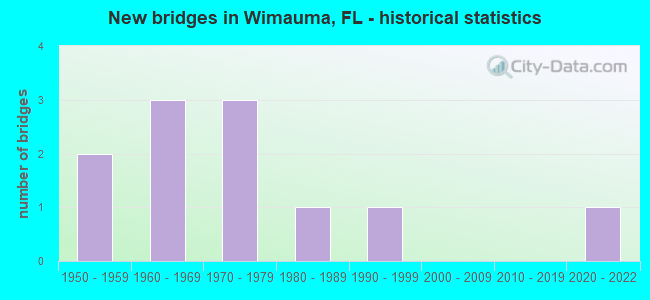
- New bridges - historical statistics
- 21950-1959
- 31960-1969
- 31970-1979
- 11980-1989
- 11990-1999
- 12020-2022


- Bridge Condition - Deck
- 25.0%Very good
- 37.5%Good
- 37.5%Satisfactory

- Bridge Condition - Superstructure
- 12.5%Very good
- 25.0%Good
- 62.5%Satisfactory

- Bridge Condition - Substructure
- 50.0%Good
- 37.5%Satisfactory
- 12.5%Fair

- Bridge Condition - Channel
- 18.2%Very good
- 45.5%Good
- 36.4%Satisfactory

- Bridge Condition - Culverts
- 33.3%Very good
- 66.7%Satisfactory
Find on map >> Show street view
Structure Number: 100003, Location: 0.3Mi. S OF SAFFOLD RD (Lat: 27.671650, Lng: -82.352214), Route carried "on" structure: US 301, Year Built: 1971, Status: Open, Structure Length: 7.67m (25.16ft), Average Daily Traffic: 6,100 (year 2020), Truck Traffic: 12%, Average Future Daily Traffic: 10,584 (year 2042), Design Load: HS 20, Features Intersected: LITTLE MANATEE RIVER
Minimum Vertical Clearance: 30+ m (98+ ft), Kilometerpoint: 4.226, Lanes on structure: 2, Base Highway Network: Yes, Owner: State Highway Agency, Approaching Roadway Width: 9.8m (32.2ft), Material/Design: Prestressed concrete, Design/Construction: Slab, Number Of Spans In Main Unit: 7, Length of Maximum Span: 11.0m (36.1ft), Curb-To-Curb Width: 12.3m (40.4ft), Out-to-Out Width: 13.2m (43.3ft)
Condition: Deck: Satisfactory, Superstructure: Satisfactory, Substructure: Satisfactory, Channel: Satisfactory, Operating Rating: 63.7 metric tons, Method Used To Determine Operating Rating: Load Factor (LF), Inventory Rating: 38.1 metric tons, Method Used To Determine Inventory Rating: Load Factor (LF), Structural Evaluation: Equal to present minimum criteria, Deck Geometry: Somewhat better than minimum adequacy, Waterway Adequacy: Better than present minimum criteria, Approach Roadway Alignment: Equal to present desirable criteria, Designated Inspection Frequency: Every 24 months, Underwater Inspection Frequency: Every 24 months, Inspection Date: March 2021, Underwater Inspection Date: Febuary 2021, Deck Structure Type: Concrete Precast Panels, Wearing Surface/Protective System: Wearing Surface: Bituminous
Find on map >> Show street view
Structure Number: 100259, Location: 4.8MI SOUTH OF SR-674 (Lat: 27.649475, Lng: -82.294369), Route carried "on" structure: County highway 579, Year Built: 1954, Status: Open, Structure Length: 3.22m (10.56ft), Average Daily Traffic: 1,000 (year 2020), Truck Traffic: 5%, Average Future Daily Traffic: 1,350 (year 2040), Features Intersected: LITTLE MANATEE R/S FORK
Minimum Vertical Clearance: 30+ m (98+ ft), Kilometerpoint: 0.325, Lanes on structure: 2, Owner: County Highway Agency, Approaching Roadway Width: 6.1m (20.0ft), Material/Design: Concrete, Design/Construction: Slab, Number Of Spans In Main Unit: 7, Length of Maximum Span: 4.7m (15.4ft), Curb-To-Curb Width: 6.2m (20.3ft), Out-to-Out Width: 6.5m (21.3ft)
Condition: Deck: Good, Superstructure: Good, Substructure: Good, Channel: Very good, Operating Rating: 39.1 metric tons, Method Used To Determine Operating Rating: Load Testing, Inventory Rating: 23.4 metric tons, Method Used To Determine Inventory Rating: Load Testing, Structural Evaluation: Equal to present minimum criteria, Deck Geometry: High priority of corrective action, Waterway Adequacy: Equal to present desirable criteria, Approach Roadway Alignment: Better than present minimum criteria, Designated Inspection Frequency: Every 24 months, Underwater Inspection Frequency: Every 24 months, Inspection Date: May 2020, Underwater Inspection Date: May 2020, Deck Structure Type: Concrete Cast-file-Place
Find on map >> Show street view
Structure Number: 10026, Location: 3.5MI SOUTH OF SR-674 (Lat: 27.662786, Lng: -82.301003), Route carried "on" structure: County highway 579, Year Built: 1954, Status: Open, Structure Length: 4.57m (14.99ft), Average Daily Traffic: 890 (year 2020), Truck Traffic: 10%, Average Future Daily Traffic: 1,113 (year 2040), Design Load: H 20, Features Intersected: LITTLE MANATEE RIVER
Minimum Vertical Clearance: 30+ m (98+ ft), Kilometerpoint: 2.260, Lanes on structure: 2, Owner: County Highway Agency, Approaching Roadway Width: 6.1m (20.0ft), Material/Design: Concrete, Design/Construction: Slab, Number Of Spans In Main Unit: 10, Length of Maximum Span: 4.6m (15.1ft), Curb-To-Curb Width: 6.1m (20.0ft), Out-to-Out Width: 6.6m (21.7ft)
Condition: Deck: Satisfactory, Superstructure: Satisfactory, Substructure: Satisfactory, Channel: Good, Operating Rating: 33.8 metric tons, Method Used To Determine Operating Rating: Load Factor (LF), Inventory Rating: 20.2 metric tons, Method Used To Determine Inventory Rating: Load Factor (LF), Structural Evaluation: Somewhat better than minimum adequacy, Deck Geometry: High priority of corrective action, Waterway Adequacy: Better than present minimum criteria, Approach Roadway Alignment: Equal to present minimum criteria, Designated Inspection Frequency: Every 24 months, Underwater Inspection Frequency: Every 24 months, Inspection Date: May 2020, Underwater Inspection Date: May 2020, Deck Structure Type: Concrete Cast-file-Place
Find on map >> Show street view
Structure Number: 100501, Location: 5 MI EAST OF US-301 (Lat: 27.705003, Lng: -82.256439), Route carried "on" structure: State highway 674, Year Built: 1984, Status: Open, Structure Length: 3.66m (12.01ft), Average Daily Traffic: 7,491 (year 2022), Truck Traffic: 13%, Average Future Daily Traffic: 12,997 (year 2042), Design Load: HS 20+Mod, Features Intersected: CARLTON BRANCH
Minimum Vertical Clearance: 30+ m (98+ ft), Kilometerpoint: 17.725, Lanes on structure: 2, Base Highway Network: Yes, Owner: State Highway Agency, Approaching Roadway Width: 9.9m (32.5ft), Material/Design: Prestressed concrete, Design/Construction: Slab, Number Of Spans In Main Unit: 4, Length of Maximum Span: 9.2m (30.2ft), Curb-To-Curb Width: 12.3m (40.4ft), Out-to-Out Width: 13.4m (44.0ft)
Condition: Deck: Very good, Superstructure: Very good, Substructure: Good, Channel: Good, Operating Rating: 58.1 metric tons, Method Used To Determine Operating Rating: Load Factor (LF), Inventory Rating: 45.4 metric tons, Method Used To Determine Inventory Rating: Load Factor (LF), Structural Evaluation: Better than present minimum criteria, Deck Geometry: Somewhat better than minimum adequacy, Waterway Adequacy: Equal to present desirable criteria, Approach Roadway Alignment: Better than present minimum criteria, Designated Inspection Frequency: Every 24 months, Inspection Date: January 2022, Deck Structure Type: Concrete Precast Panels, Wearing Surface/Protective System: Wearing Surface: Bituminous
Find on map >> Show street view
Structure Number: 100577, Location: 5.1 MI WEST OF CR-39 (Lat: 27.704908, Lng: -82.229611), Route carried "on" structure: State highway 674, Year Built: 1992, Status: Open, Structure Length: 3.49m (11.45ft), Average Daily Traffic: 7,491 (year 2022), Truck Traffic: 13%, Average Future Daily Traffic: 12,997 (year 2042), Design Load: HS 20+Mod, Features Intersected: PIERCE BRANCH
Minimum Vertical Clearance: 30+ m (98+ ft), Kilometerpoint: 20.352, Lanes on structure: 2, Base Highway Network: Yes, Owner: State Highway Agency, Approaching Roadway Width: 9.8m (32.2ft), Material/Design: Concrete continuous, Design/Construction: Slab, Number Of Spans In Main Unit: 5, Length of Maximum Span: 7.7m (25.3ft), Curb-To-Curb Width: 13.4m (44.0ft), Out-to-Out Width: 14.4m (47.2ft)
Condition: Deck: Good, Superstructure: Good, Substructure: Good, Channel: Satisfactory, Operating Rating: 37.9 metric tons, Method Used To Determine Operating Rating: Load Factor (LF), Inventory Rating: 22.7 metric tons, Method Used To Determine Inventory Rating: Load Factor (LF), Structural Evaluation: Somewhat better than minimum adequacy, Deck Geometry: Equal to present minimum criteria, Waterway Adequacy: Equal to present desirable criteria, Approach Roadway Alignment: Equal to present desirable criteria, Designated Inspection Frequency: Every 24 months, Underwater Inspection Frequency: Every 24 months, Inspection Date: January 2022, Underwater Inspection Date: December 2021, Deck Structure Type: Concrete Cast-file-Place
Find on map >> Show street view
Structure Number: 104308, Location: 0.3MI EAST OF US-301 (Lat: 27.690417, Lng: -82.338083), Route carried "on" structure: County highway , Year Built: 1964, Status: Open, Structure Length: 1.60m (5.25ft), Average Daily Traffic: 1,000 (year 2020), Truck Traffic: 5%, Average Future Daily Traffic: 1,225 (year 2040), Design Load: H 15, Features Intersected: DUG CREEK, Facility Carried by Structure: BISHOP ROAD
Minimum Vertical Clearance: 30+ m (98+ ft), Kilometerpoint: 0.000, Lanes on structure: 2, Owner: County Highway Agency, Approaching Roadway Width: 6.3m (20.7ft), Material/Design: Prestressed concrete, Design/Construction: Channel Beam, Number Of Spans In Main Unit: 2, Length of Maximum Span: 8.0m (26.2ft), Curb-To-Curb Width: 8.6m (28.2ft), Out-to-Out Width: 9.2m (30.2ft)
Condition: Deck: Good, Superstructure: Satisfactory, Substructure: Good, Channel: Good, Operating Rating: 52.5 metric tons, Method Used To Determine Operating Rating: Load Factor (LF), Inventory Rating: 31.6 metric tons, Method Used To Determine Inventory Rating: Load Factor (LF), Structural Evaluation: Equal to present minimum criteria, Deck Geometry: Somewhat better than minimum adequacy, Waterway Adequacy: Better than present minimum criteria, Approach Roadway Alignment: Equal to present desirable criteria, Designated Inspection Frequency: Every 24 months, Inspection Date: May 2020, Deck Structure Type: Concrete Cast-file-Place, Wearing Surface/Protective System: Wearing Surface: Bituminous
Find on map >> Show street view
Structure Number: 104332, Location: 1.2MI SOUTH OF SR-674 (Lat: 27.689183, Lng: -82.244875), Route carried "on" structure: County highway , Year Built: 1966, Status: Posted for load, Structure Length: 4.13m (13.55ft), Average Daily Traffic: 990 (year 2021), Truck Traffic: 5%, Average Future Daily Traffic: 1,237 (year 2041), Design Load: H 10, Features Intersected: LITTLE MANATEE RIVER, Facility Carried by Structure: GRANGE HALL ROAD
Minimum Vertical Clearance: 30+ m (98+ ft), Kilometerpoint: 9.135, Lanes on structure: 2, Owner: County Highway Agency, Approaching Roadway Width: 6.1m (20.0ft), Material/Design: Concrete, Design/Construction: Slab, Number Of Spans In Main Unit: 9, Length of Maximum Span: 4.6m (15.1ft), Curb-To-Curb Width: 7.2m (23.6ft), Out-to-Out Width: 7.7m (25.3ft)
Condition: Deck: Satisfactory, Superstructure: Satisfactory, Substructure: Fair, Channel: Satisfactory, Operating Rating: 31.6 metric tons, Method Used To Determine Operating Rating: Load Factor (LF), Inventory Rating: 18.9 metric tons, Method Used To Determine Inventory Rating: Load Factor (LF), Structural Evaluation: Somewhat better than minimum adequacy, Deck Geometry: Meets minimum limits, Waterway Adequacy: Better than present minimum criteria, Approach Roadway Alignment: Equal to present desirable criteria, Bridge Posting: Required (Relationship of Operating Rating to Maximum Legal Load: 0.1 - 9.9% below), Designated Inspection Frequency: Every 24 months, Other Special Inspection Frequency: Every 12 months, Inspection Date: May 2021, Other Special Inspection Date: May 2021, Deck Structure Type: Concrete Cast-file-Place
Find on map >> Show street view
Structure Number: 104346, Location: 0.4 MI EAST OF US-301 (Lat: 27.679539, Lng: -82.339783), Route carried "on" structure: County highway , Year Built: 1975, Status: Open, Structure Length: 2.76m (9.06ft), Average Daily Traffic: 759 (year 2020), Truck Traffic: 5%, Average Future Daily Traffic: 949 (year 2040), Design Load: HS 15, Features Intersected: DUG CREEK, Facility Carried by Structure: BONITA DRIVE
Minimum Vertical Clearance: 30+ m (98+ ft), Kilometerpoint: 0.000, Lanes on structure: 2, Owner: County Highway Agency, Approaching Roadway Width: 7.0m (23.0ft), Material/Design: Prestressed concrete, Design/Construction: Channel Beam, Number Of Spans In Main Unit: 3, Length of Maximum Span: 9.2m (30.2ft), Curb or Sidewalk Widths: Left: 0.6m (2.0ft), Right: 0.6m (2.0ft), Curb-To-Curb Width: 8.0m (26.2ft), Out-to-Out Width: 9.8m (32.2ft)
Condition: Deck: Very good, Superstructure: Satisfactory, Substructure: Satisfactory, Channel: Satisfactory, Operating Rating: 51.4 metric tons, Method Used To Determine Operating Rating: Load Factor (LF), Inventory Rating: 28.7 metric tons, Method Used To Determine Inventory Rating: Load Factor (LF), Structural Evaluation: Equal to present minimum criteria, Deck Geometry: Somewhat better than minimum adequacy, Waterway Adequacy: Better than present minimum criteria, Approach Roadway Alignment: Equal to present desirable criteria, Designated Inspection Frequency: Every 24 months, Inspection Date: May 2020, Deck Structure Type: Concrete Cast-file-Place, Wearing Surface/Protective System: Wearing Surface: Bituminous
Find on map >> Show street view
Structure Number: 104366, Location: 0.3 MI EAST OF US-301 (Lat: 27.671050, Lng: -82.344603), Route carried "on" structure: County highway , Year Built: 1966, Status: Open, Structure Length: 1.41m (4.63ft), Average Daily Traffic: 1,000 (year 2020), Truck Traffic: 3%, Average Future Daily Traffic: 1,250 (year 2040), Design Load: H 20, Features Intersected: DUG CREEK, Facility Carried by Structure: SAFFOLD ROAD
Minimum Vertical Clearance: 30+ m (98+ ft), Kilometerpoint: 0.000, Lanes on structure: 2, Owner: County Highway Agency, Approaching Roadway Width: 6.2m (20.3ft), Material/Design: Steel, Design/Construction: Culvert, Number Of Spans In Main Unit: 5, Length of Maximum Span: 2.2m (7.2ft)
Condition: Channel: Good, Culverts: Satisfactory, Structural Evaluation: Equal to present minimum criteria, Waterway Adequacy: Equal to present desirable criteria, Approach Roadway Alignment: Equal to present desirable criteria, Designated Inspection Frequency: Every 24 months, Inspection Date: May 2020
Find on map >> Show street view
Structure Number: 104494, Location: 0.1MI S/O DORMAN RD (Lat: 27.841444, Lng: -82.199639), Route carried "on" structure: County highway , Year Built: 2020, Status: Open, Structure Length: 0.69m (2.26ft), Average Daily Traffic: 1,330 (year 2020), Truck Traffic: 5%, Average Future Daily Traffic: 1,663 (year 2040), Design Load: Greater than HL93, Features Intersected: FISH HAWK CREEK BRANCH, Facility Carried by Structure: BOYETTE RD
Minimum Vertical Clearance: 30+ m (98+ ft), Kilometerpoint: 5.367, Lanes on structure: 2, Owner: County Highway Agency, Approaching Roadway Width: 6.1m (20.0ft), Material/Design: Concrete, Design/Construction: Culvert, Number Of Spans In Main Unit: 2, Length of Maximum Span: 3.7m (12.1ft), Curb-To-Curb Width: 11.1m (36.4ft), Out-to-Out Width: 12.0m (39.4ft)
Condition: Channel: Very good, Culverts: Very good, Operating Rating: 45.7 metric tons, Method Used To Determine Operating Rating: Load and Resistance Factor (LRFR), Inventory Rating: 35.3 metric tons, Method Used To Determine Inventory Rating: Load and Resistance Factor (LRFR), Structural Evaluation: Equal to present desirable criteria, Deck Geometry: Equal to present minimum criteria, Waterway Adequacy: Equal to present desirable criteria, Approach Roadway Alignment: Equal to present desirable criteria, Designated Inspection Frequency: Every 24 months, Underwater Inspection Frequency: Every 22 months, Inspection Date: March 2020, Underwater Inspection Date: April 2020
Find on map >> Show street view
Structure Number: 130044, Location: 6.6 MI EAST OF US-301 (Lat: 27.602189, Lng: -82.315144), Route carried "on" structure: State highway 62, Year Built: 1973, Status: Open, Structure Length: 1.33m (4.36ft), Average Daily Traffic: 4,200 (year 2020), Truck Traffic: 8%, Average Future Daily Traffic: 7,287 (year 2042), Design Load: HS 20, Features Intersected: GAMBLE CREEK
Minimum Vertical Clearance: 30+ m (98+ ft), Kilometerpoint: 11.187, Lanes on structure: 2, Base Highway Network: Yes, Owner: State Highway Agency, Approaching Roadway Width: 9.1m (29.9ft), Material/Design: Concrete, Design/Construction: Culvert, Number Of Spans In Main Unit: 4, Length of Maximum Span: 3.4m (11.2ft)
Condition: Channel: Good, Culverts: Satisfactory, Operating Rating: 67.1 metric tons, Method Used To Determine Operating Rating: Load Factor (LF), Inventory Rating: 40.8 metric tons, Method Used To Determine Inventory Rating: Load Factor (LF), Structural Evaluation: Equal to present minimum criteria, Waterway Adequacy: Equal to present desirable criteria, Approach Roadway Alignment: Equal to present desirable criteria, Designated Inspection Frequency: Every 24 months, Underwater Inspection Frequency: Every 24 months, Inspection Date: November 2021, Underwater Inspection Date: October 2021