Bridge Statistics for Wilton, New York (NY)
Condition, Traffic, Stress, Structural Evaluation, Project Costs
- National Bridge Inventory (NBI) Statistics
- 20Number of bridges
- 141ft / 43.4mTotal length
- $21,751,000Total costs
- 190,503Total average daily traffic
- 12,637Total average daily truck traffic
- National Bridge Inventory (NBI) Registered Bridges for Wilton
- No street view available for this location
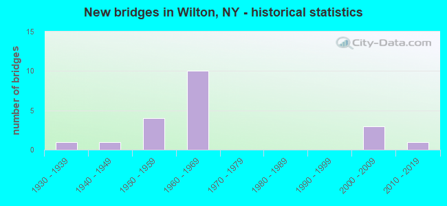
- New bridges - historical statistics
- 11930-1939
- 11940-1949
- 41950-1959
- 101960-1969
- 32000-2009
- 12010-2019
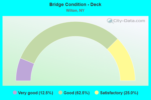
- Bridge Condition - Deck
- 12.5%Very good
- 62.5%Good
- 25.0%Satisfactory
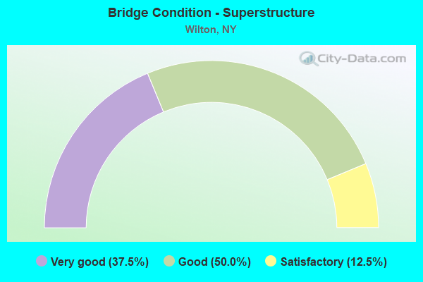
- Bridge Condition - Superstructure
- 37.5%Very good
- 50.0%Good
- 12.5%Satisfactory
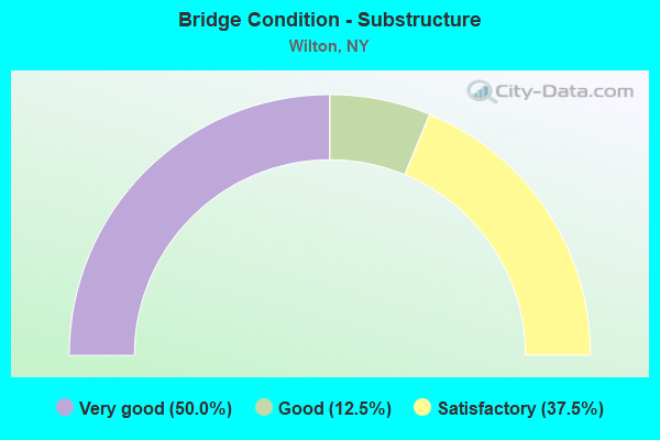
- Bridge Condition - Substructure
- 50.0%Very good
- 12.5%Good
- 37.5%Satisfactory
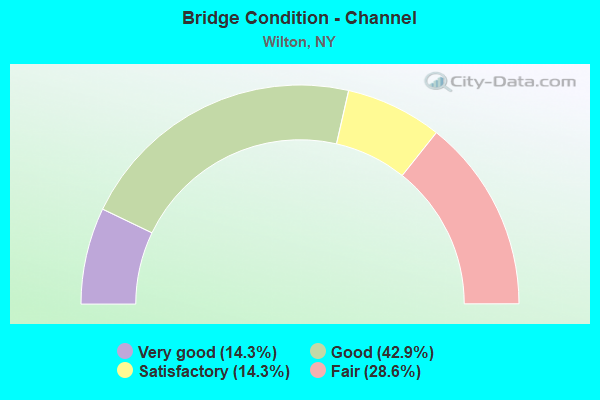
- Bridge Condition - Channel
- 14.3%Very good
- 42.9%Good
- 14.3%Satisfactory
- 28.6%Fair
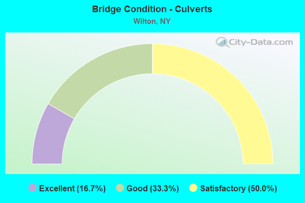
- Bridge Condition - Culverts
- 16.7%Excellent
- 33.3%Good
- 50.0%Satisfactory
Find on map >> Show street view
Structure Number: 100566, Location: 0.1 MI NO BALLARD RD (Lat: 43.180878, Lng: -73.745389), Route carried "on" structure: US 9, Year Built: 1934, Status: Open, Structure Length: 0.73m (2.40ft), Average Daily Traffic: 5,597 (year 2018), Truck Traffic: 6%, Average Future Daily Traffic: 6,799 (year 2040), Features Intersected: LITTLE SNOOK KILL
Minimum Vertical Clearance: 30+ m (98+ ft), Kilometerpoint: 42.912, Lanes on structure: 2, Base Highway Network: Yes, Owner: State Highway Agency, Approaching Roadway Width: 11.3m (37.1ft), Skew: 6 degrees, Material/Design: Concrete, Design/Construction: Culvert, Number Of Spans In Main Unit: 1, Length of Maximum Span: 7.0m (23.0ft)
Condition: Channel: Fair, Culverts: Satisfactory, Operating Rating: 73.5 metric tons, Method Used To Determine Operating Rating: Load Factor (LF), Inventory Rating: 43.5 metric tons, Method Used To Determine Inventory Rating: Load Factor (LF), Structural Evaluation: Equal to present minimum criteria, Waterway Adequacy: Superior to present desirable criteria, Approach Roadway Alignment: Meets minimum limits, Length Of Structure Improvement: 0.73m (2.40ft), Designated Inspection Frequency: Every 24 months, Inspection Date: August 2020, Bridge Improvement Cost: $388,000, Roadway Improvement Cost: $227,000, Total Project Cost: $615,000 ( Estimate for 2021), Wearing Surface/Protective System: Wearing Surface: Bituminous
Find on map >> Show street view
Structure Number: 1033351, Location: IN WILTON (Lat: 43.117731, Lng: -73.745408), Route carried "on" structure: Interstate 87, Year Built: 2007, Status: Open, Structure Length: 3.29m (10.79ft), Average Daily Traffic: 25,545 (year 2014), Truck Traffic: 12%, Design Load: HS 25 or greater, Features Intersected: DELAWARE & HUDSON
Minimum Vertical Clearance: 30+ m (98+ ft), Kilometerpoint: 38.278, Lanes on structure: 3, Base Highway Network: Yes, Owner: State Highway Agency, Approaching Roadway Width: 15.5m (50.9ft), Skew: 4 degrees, Material/Design: Steel, Design/Construction: Stringer/Multi-beam, Number Of Spans In Main Unit: 1, Length of Maximum Span: 31.1m (102.0ft), Curb-To-Curb Width: 15.6m (51.2ft), Out-to-Out Width: 16.5m (54.1ft)
Condition: Deck: Good, Superstructure: Very good, Substructure: Very good, Operating Rating: 76.0 metric tons, Method Used To Determine Operating Rating: Load Factor (LF), Inventory Rating: 45.0 metric tons, Method Used To Determine Inventory Rating: Load Factor (LF), Structural Evaluation: Equal to present desirable criteria, Deck Geometry: Somewhat better than minimum adequacy, Underclear: Equal to present minimum criteria, Approach Roadway Alignment: Equal to present desirable criteria, Length Of Structure Improvement: 3.29m (10.79ft), Designated Inspection Frequency: Every 24 months, Inspection Date: August 2021, Bridge Improvement Cost: $2,316,000, Roadway Improvement Cost: $1,356,000, Total Project Cost: $3,672,000 ( Estimate for 2021), Deck Structure Type: Concrete Cast-file-Place, Wearing Surface/Protective System: Wearing Surface: Integral Concrete, Deck Protection: Epoxy Coated Reinforcing
Find on map >> Show street view
Structure Number: 1033352, Location: IN WILTON (Lat: 43.117983, Lng: -73.744300), Route carried "on" structure: Interstate 87, Year Built: 2007, Status: Open, Structure Length: 3.29m (10.79ft), Average Daily Traffic: 18,404 (year 2018), Truck Traffic: 13%, Average Future Daily Traffic: 29,165 (year 2040), Design Load: HS 25 or greater, Features Intersected: DELAWARE & HUDSON
Minimum Vertical Clearance: 30+ m (98+ ft), Kilometerpoint: 38.262, Lanes on structure: 3, Base Highway Network: Yes, Owner: State Highway Agency, Approaching Roadway Width: 15.5m (50.9ft), Skew: 4 degrees, Material/Design: Steel, Design/Construction: Stringer/Multi-beam, Number Of Spans In Main Unit: 1, Length of Maximum Span: 31.1m (102.0ft), Curb-To-Curb Width: 15.6m (51.2ft), Out-to-Out Width: 16.5m (54.1ft)
Condition: Deck: Good, Superstructure: Very good, Substructure: Very good, Operating Rating: 76.0 metric tons, Method Used To Determine Operating Rating: Load Factor (LF), Inventory Rating: 45.0 metric tons, Method Used To Determine Inventory Rating: Load Factor (LF), Structural Evaluation: Equal to present desirable criteria, Deck Geometry: Somewhat better than minimum adequacy, Underclear: High priority of corrective action, Approach Roadway Alignment: Equal to present desirable criteria, Length Of Structure Improvement: 3.29m (10.79ft), Designated Inspection Frequency: Every 24 months, Inspection Date: August 2021, Bridge Improvement Cost: $2,343,000, Roadway Improvement Cost: $1,372,000, Total Project Cost: $3,715,000 ( Estimate for 2021), Deck Structure Type: Concrete Cast-file-Place, Wearing Surface/Protective System: Wearing Surface: Integral Concrete, Deck Protection: Epoxy Coated Reinforcing
Find on map >> Show street view
Structure Number: 103336, Location: 3.5 MI S I87 & BALLARD RD (Lat: 43.125153, Lng: -73.740086), Route carried "on" structure: Other road , Year Built: 1962, Status: Open, Structure Length: 4.51m (14.80ft), Average Daily Traffic: 6,855 (year 2017), Truck Traffic: 3%, Average Future Daily Traffic: 9,597 (year 2037), Design Load: H 20, Features Intersected: RTE I87, Facility Carried by Structure: JONES ROAD
Minimum Vertical Clearance: 30+ m (98+ ft), Kilometerpoint: 4.521, Lanes on structure: 2, Lanes under structure: 3, Owner: State Highway Agency, Approaching Roadway Width: 9.4m (30.8ft), Skew: 1 degrees, Material/Design: Steel, Design/Construction: Stringer/Multi-beam, Number Of Spans In Main Unit: 3, Length of Maximum Span: 17.0m (55.8ft), Curb or Sidewalk Widths: Left: 0.5m (1.6ft), Right: 0.5m (1.6ft), Curb-To-Curb Width: 9.2m (30.2ft), Out-to-Out Width: 10.7m (35.1ft)
Condition: Deck: Good, Superstructure: Good, Substructure: Very good, Operating Rating: 49.0 metric tons, Method Used To Determine Operating Rating: Load Factor (LF), Inventory Rating: 29.0 metric tons, Method Used To Determine Inventory Rating: Load Factor (LF), Structural Evaluation: Better than present minimum criteria, Deck Geometry: High priority of corrective action, Underclear: Meets minimum limits, Approach Roadway Alignment: Equal to present desirable criteria, Length Of Structure Improvement: 4.51m (14.80ft), Designated Inspection Frequency: Every 24 months, Inspection Date: September 2021, Bridge Improvement Cost: $1,052,000, Roadway Improvement Cost: $616,000, Total Project Cost: $1,669,000 ( Estimate for 2021), Deck Structure Type: Concrete Cast-file-Place, Wearing Surface/Protective System: Wearing Surface: Integral Concrete
Find on map >> Show street view
Structure Number: 103337, Location: JCT I87 & BALLARD ROAD (Lat: 43.169528, Lng: -73.712783), Route carried "on" structure: County highway , Year Built: 1962, Year Reconstructed: 2009, Status: Open, Structure Length: 9.57m (31.40ft), Average Daily Traffic: 9,034 (year 2015), Truck Traffic: 10%, Average Future Daily Traffic: 11,177 (year 2040), Design Load: H 20, Features Intersected: 87I 87I15091277NB, RTE I, Facility Carried by Structure: BALLARD ROAD
Minimum Vertical Clearance: 30+ m (98+ ft), Kilometerpoint: 2.977, Lanes on structure: 2, Lanes under structure: 6, Owner: State Highway Agency, Approaching Roadway Width: 14.3m (46.9ft), Skew: 1 degrees, Material/Design: Steel, Design/Construction: Stringer/Multi-beam, Number Of Spans In Main Unit: 6, Length of Maximum Span: 17.1m (56.1ft), Curb or Sidewalk Widths: Left: 0.3m (1.0ft), Right: 0.3m (1.0ft), Curb-To-Curb Width: 9.1m (29.9ft), Out-to-Out Width: 10.8m (35.4ft)
Condition: Deck: Satisfactory, Superstructure: Good, Substructure: Satisfactory, Operating Rating: 55.3 metric tons, Method Used To Determine Operating Rating: Load Factor (LF), Inventory Rating: 32.7 metric tons, Method Used To Determine Inventory Rating: Load Factor (LF), Structural Evaluation: Equal to present minimum criteria, Deck Geometry: Meets minimum limits, Underclear: High priority of corrective action, Approach Roadway Alignment: Equal to present desirable criteria, Length Of Structure Improvement: 9.57m (31.40ft), Designated Inspection Frequency: Every 24 months, Inspection Date: May 2021, Bridge Improvement Cost: $2,109,000, Roadway Improvement Cost: $1,235,000, Total Project Cost: $3,345,000 ( Estimate for 2021), Deck Structure Type: Concrete Cast-file-Place, Wearing Surface/Protective System: Wearing Surface: Integral Concrete
Find on map >> Show street view
Structure Number: 1033381, Location: 1.2 MI N I87 & BALLARD RD (Lat: 43.185750, Lng: -73.706850), Route carried "on" structure: Interstate 87, Year Built: 1962, Status: Open, Structure Length: 0.98m (3.22ft), Average Daily Traffic: 24,722 (year 2007), Truck Traffic: 12%, Design Load: H 20, Features Intersected: SNOOK KILL
Minimum Vertical Clearance: 30+ m (98+ ft), Kilometerpoint: 46.468, Lanes on structure: 3, Base Highway Network: Yes, Owner: State Highway Agency, Approaching Roadway Width: 15.8m (51.8ft), Material/Design: Steel, Design/Construction: Culvert, Number Of Spans In Main Unit: 2, Length of Maximum Span: 4.5m (14.8ft)
Condition: Channel: Good, Culverts: Satisfactory, Operating Rating: 72.8 metric tons, Method Used To Determine Operating Rating: Field evaluation and documented engineering judgment, Inventory Rating: 29.4 metric tons, Method Used To Determine Inventory Rating: Field evaluation and documented engineering judgment, Structural Evaluation: Equal to present minimum criteria, Waterway Adequacy: Superior to present desirable criteria, Approach Roadway Alignment: Equal to present desirable criteria, Length Of Structure Improvement: 0.97m (3.18ft), Designated Inspection Frequency: Every 24 months, Inspection Date: July 2021, Bridge Improvement Cost: $272,000, Roadway Improvement Cost: $160,000, Total Project Cost: $432,000 ( Estimate for 2021)
Find on map >> Show street view
Structure Number: 1033382, Location: 1.2 MI N I87 & BALLARD RD (Lat: 43.185508, Lng: -73.706122), Route carried "on" structure: Interstate 87, Year Built: 1962, Status: Open, Structure Length: 0.98m (3.22ft), Average Daily Traffic: 18,530 (year 2019), Truck Traffic: 9%, Average Future Daily Traffic: 29,363 (year 2040), Features Intersected: SNOOK KILL
Minimum Vertical Clearance: 30+ m (98+ ft), Kilometerpoint: 46.452, Lanes on structure: 3, Base Highway Network: Yes, Owner: State Highway Agency, Approaching Roadway Width: 15.8m (51.8ft), Material/Design: Steel, Design/Construction: Culvert, Number Of Spans In Main Unit: 2, Length of Maximum Span: 4.5m (14.8ft)
Condition: Channel: Good, Culverts: Satisfactory, Operating Rating: 75.5 metric tons, Method Used To Determine Operating Rating: Field evaluation and documented engineering judgment, Inventory Rating: 29.4 metric tons, Method Used To Determine Inventory Rating: Field evaluation and documented engineering judgment, Structural Evaluation: Equal to present minimum criteria, Waterway Adequacy: Superior to present desirable criteria, Approach Roadway Alignment: Equal to present desirable criteria, Length Of Structure Improvement: 0.97m (3.18ft), Designated Inspection Frequency: Every 24 months, Inspection Date: July 2021, Bridge Improvement Cost: $272,000, Roadway Improvement Cost: $160,000, Total Project Cost: $432,000 ( Estimate for 2021)
Find on map >> Show street view
Structure Number: 10334, Location: JCT I87 & GANSEVOORT RD (Lat: 43.191183, Lng: -73.704158), Route carried "on" structure: County highway , Year Built: 1962, Year Reconstructed: 2009, Status: Open, Structure Length: 9.94m (32.61ft), Average Daily Traffic: 761 (year 2018), Truck Traffic: 11%, Average Future Daily Traffic: 1,107 (year 2040), Design Load: HS 25 or greater, Features Intersected: 87I 87I15091293 NB, RTE, Facility Carried by Structure: CR 32, GANSEVOORT
Minimum Vertical Clearance: 30+ m (98+ ft), Kilometerpoint: 3.652, Lanes on structure: 2, Lanes under structure: 6, Owner: State Highway Agency, Approaching Roadway Width: 9.1m (29.9ft), Material/Design: Steel, Design/Construction: Stringer/Multi-beam, Number Of Spans In Main Unit: 6, Length of Maximum Span: 19.2m (63.0ft), Curb or Sidewalk Widths: Left: 0.5m (1.6ft), Right: 0.5m (1.6ft), Curb-To-Curb Width: 9.2m (30.2ft), Out-to-Out Width: 10.8m (35.4ft)
Condition: Deck: Good, Superstructure: Good, Substructure: Satisfactory, Operating Rating: 16.2 metric tons, Method Used To Determine Operating Rating: Load and Resistance Factor Rating (LRFR) rating reported by rating factor(RF) method using HL-93 loadings, Inventory Rating: 12.3 metric tons, Method Used To Determine Inventory Rating: Load and Resistance Factor Rating (LRFR) rating reported by rating factor(RF) method using HL-93 loadings, Structural Evaluation: High priority of corrective action, Deck Geometry: Equal to present minimum criteria, Underclear: Meets minimum limits, Approach Roadway Alignment: Meets minimum limits, Length Of Structure Improvement: 9.93m (32.58ft), Designated Inspection Frequency: Every 24 months, Inspection Date: May 2021, Bridge Improvement Cost: $2,172,000, Roadway Improvement Cost: $1,272,000, Total Project Cost: $3,444,000 ( Estimate for 2021), Deck Structure Type: Concrete Cast-file-Place, Wearing Surface/Protective System: Wearing Surface: Integral Concrete
Find on map >> Show street view
Structure Number: 109584, Location: 3.4 MI S I87 & BALLARD RD (Lat: 43.124958, Lng: -73.739031), Route carried "on" structure: Other road , Year Built: 1962, Status: Open, Structure Length: 4.51m (14.80ft), Average Daily Traffic: 6,855 (year 2017), Truck Traffic: 3%, Average Future Daily Traffic: 9,597 (year 2037), Design Load: H 20, Features Intersected: RTE I87, Facility Carried by Structure: JONES ROAD
Minimum Vertical Clearance: 30+ m (98+ ft), Kilometerpoint: 4.618, Lanes on structure: 2, Lanes under structure: 3, Owner: State Highway Agency, Approaching Roadway Width: 9.4m (30.8ft), Skew: 1 degrees, Material/Design: Steel, Design/Construction: Stringer/Multi-beam, Number Of Spans In Main Unit: 3, Length of Maximum Span: 17.0m (55.8ft), Curb or Sidewalk Widths: Left: 0.5m (1.6ft), Right: 0.5m (1.6ft), Curb-To-Curb Width: 9.2m (30.2ft), Out-to-Out Width: 10.8m (35.4ft)
Condition: Deck: Good, Superstructure: Good, Substructure: Good, Operating Rating: 54.4 metric tons, Method Used To Determine Operating Rating: Load Factor (LF), Inventory Rating: 32.7 metric tons, Method Used To Determine Inventory Rating: Load Factor (LF), Structural Evaluation: Better than present minimum criteria, Deck Geometry: High priority of corrective action, Underclear: Meets minimum limits, Approach Roadway Alignment: Better than present minimum criteria, Length Of Structure Improvement: 4.51m (14.80ft), Designated Inspection Frequency: Every 24 months, Inspection Date: September 2021, Bridge Improvement Cost: $1,055,000, Roadway Improvement Cost: $618,000, Total Project Cost: $1,674,000 ( Estimate for 2021), Deck Structure Type: Concrete Cast-file-Place, Wearing Surface/Protective System: Wearing Surface: Integral Concrete
Find on map >> Show street view
Structure Number: 220287, Location: 1.1 ML E WILTON (Lat: 43.173339, Lng: -73.723881), Route carried "on" structure: County highway , Year Built: 1950, Status: Open, Structure Length: 0.85m (2.79ft), Average Daily Traffic: 8,563 (year 2011), Truck Traffic: 5%, Average Future Daily Traffic: 10,594 (year 2040), Design Load: H 20, Features Intersected: SNOOK KILL, Facility Carried by Structure: BALLARD RD CR33
Minimum Vertical Clearance: 30+ m (98+ ft), Kilometerpoint: 1.899, Lanes on structure: 2, Owner: County Highway Agency, Approaching Roadway Width: 14.9m (48.9ft), Material/Design: Steel, Design/Construction: Culvert, Number Of Spans In Main Unit: 2, Length of Maximum Span: 3.6m (11.8ft)
Condition: Channel: Good, Culverts: Good, Operating Rating: 72.5 metric tons, Method Used To Determine Operating Rating: Field evaluation and documented engineering judgment, Inventory Rating: 32.7 metric tons, Method Used To Determine Inventory Rating: Field evaluation and documented engineering judgment, Structural Evaluation: Better than present minimum criteria, Waterway Adequacy: Equal to present desirable criteria, Approach Roadway Alignment: Equal to present desirable criteria, Length Of Structure Improvement: 0.85m (2.79ft), Designated Inspection Frequency: Every 24 months, Inspection Date: March 2020, Bridge Improvement Cost: $225,000, Roadway Improvement Cost: $132,000, Total Project Cost: $356,000 ( Estimate for 2021), Wearing Surface/Protective System: Wearing Surface: Bituminous
Find on map >> Show street view
Structure Number: 220288, Location: 1 MI NW I87 - EXIT 16 (Lat: 43.182511, Lng: -73.722414), Route carried "on" structure: Other road , Year Built: 2010, Status: Open, Structure Length: 1.13m (3.71ft), Average Daily Traffic: 306 (year 2017), Truck Traffic: 6%, Average Future Daily Traffic: 428 (year 2037), Design Load: HS 25 or greater, Features Intersected: SNOOK KILL, Facility Carried by Structure: NORTH RD
Minimum Vertical Clearance: 30+ m (98+ ft), Kilometerpoint: 1.561, Lanes on structure: 2, Owner: County Highway Agency, Approaching Roadway Width: 9.1m (29.9ft), Material/Design: Concrete, Design/Construction: Culvert, Number Of Spans In Main Unit: 1, Length of Maximum Span: 11.0m (36.1ft), Curb-To-Curb Width: 7.3m (24.0ft), Out-to-Out Width: 8.3m (27.2ft)
Condition: Channel: Very good, Culverts: Excellent, Operating Rating: 64.4 metric tons, Method Used To Determine Operating Rating: Load Factor (LF), Inventory Rating: 48.1 metric tons, Method Used To Determine Inventory Rating: Load Factor (LF), Structural Evaluation: Superior to present desirable criteria, Deck Geometry: Somewhat better than minimum adequacy, Waterway Adequacy: Equal to present desirable criteria, Approach Roadway Alignment: Meets minimum limits, Length Of Structure Improvement: 1.12m (3.67ft), Designated Inspection Frequency: Every 24 months, Inspection Date: March 2020, Bridge Improvement Cost: $165,000, Roadway Improvement Cost: $97,000, Total Project Cost: $262,000 ( Estimate for 2021), Wearing Surface/Protective System: Wearing Surface: Bituminous
Find on map >> Show street view
Structure Number: 226002, Location: 1.5 MI NE I87 EXIT 15 (Lat: 43.122389, Lng: -73.728983), Route carried "on" structure: Other road , Year Built: 1956, Status: Open, Structure Length: 1.31m (4.30ft), Average Daily Traffic: 6,855 (year 2017), Truck Traffic: 3%, Average Future Daily Traffic: 9,597 (year 2037), Features Intersected: DELAWARE & HUDSON, Facility Carried by Structure: JONES ROAD
Minimum Vertical Clearance: 30+ m (98+ ft), Kilometerpoint: 5.567, Lanes on structure: 2, Owner: County Highway Agency, Approaching Roadway Width: 7.3m (24.0ft), Skew: 1 degrees, Material/Design: Steel, Design/Construction: Stringer/Multi-beam, Number Of Spans In Main Unit: 1, Length of Maximum Span: 11.6m (38.1ft), Curb or Sidewalk Widths: Left: 0.8m (2.6ft), Right: 0.8m (2.6ft), Curb-To-Curb Width: 8.0m (26.2ft), Out-to-Out Width: 10.2m (33.5ft)
Condition: Deck: Satisfactory, Superstructure: Satisfactory, Substructure: Satisfactory, Operating Rating: 68.4 metric tons, Method Used To Determine Operating Rating: Load and Resistance Factor Rating (LRFR) rating reported by rating factor(RF) method using HL-93 loadings, Inventory Rating: 52.5 metric tons, Method Used To Determine Inventory Rating: Load and Resistance Factor Rating (LRFR) rating reported by rating factor(RF) method using HL-93 loadings, Structural Evaluation: Equal to present minimum criteria, Deck Geometry: High priority of replacement, Underclear: Meets minimum limits, Approach Roadway Alignment: Better than present minimum criteria, Length Of Structure Improvement: 1.31m (4.30ft), Designated Inspection Frequency: Every 24 months, Inspection Date: July 2020, Bridge Improvement Cost: $760,000, Roadway Improvement Cost: $445,000, Total Project Cost: $1,205,000 ( Estimate for 2021), Deck Structure Type: Concrete Cast-file-Place, Wearing Surface/Protective System: Wearing Surface: Bituminous
Find on map >> Show street view
Structure Number: 33045, Location: 1.6 MI W JCT SH 50 & SH 3 (Lat: 43.193497, Lng: -73.684317), Route carried "on" structure: Other road , Year Built: 2007, Status: Open, Structure Length: 1.28m (4.20ft), Average Daily Traffic: 193 (year 2017), Truck Traffic: 6%, Average Future Daily Traffic: 270 (year 2037), Design Load: HS 25 or greater, Features Intersected: SNOOK KILL, Facility Carried by Structure: STRONG RD
Minimum Vertical Clearance: 30+ m (98+ ft), Kilometerpoint: 0.483, Lanes on structure: 2, Owner: County Highway Agency, Approaching Roadway Width: 8.8m (28.9ft), Skew: 1 degrees, Material/Design: Concrete, Design/Construction: Frame, Number Of Spans In Main Unit: 1, Length of Maximum Span: 12.2m (40.0ft), Curb-To-Curb Width: 8.8m (28.9ft), Out-to-Out Width: 9.7m (31.8ft)
Condition: Deck: Very good, Superstructure: Very good, Substructure: Very good, Channel: Fair, Operating Rating: 69.9 metric tons, Method Used To Determine Operating Rating: Load Factor (LF), Inventory Rating: 41.7 metric tons, Method Used To Determine Inventory Rating: Load Factor (LF), Structural Evaluation: Equal to present desirable criteria, Deck Geometry: Equal to present minimum criteria, Waterway Adequacy: Superior to present desirable criteria, Approach Roadway Alignment: Equal to present desirable criteria, Length Of Structure Improvement: 1.28m (4.20ft), Designated Inspection Frequency: Every 24 months, Inspection Date: June 2021, Bridge Improvement Cost: $451,000, Roadway Improvement Cost: $264,000, Total Project Cost: $716,000 ( Estimate for 2021), Wearing Surface/Protective System: Wearing Surface: Bituminous
Find on map >> Show street view
Structure Number: 330451, Location: 2.5 MI SW OF GANSEVOORT (Lat: 43.187403, Lng: -73.698983), Route carried "on" structure: Other road , Year Built: 1941, Status: Open, Structure Length: 0.98m (3.22ft), Average Daily Traffic: 739 (year 2019), Truck Traffic: 7%, Average Future Daily Traffic: 1,035 (year 2039), Design Load: H 20, Features Intersected: SNOOK KILL, Facility Carried by Structure: DIMMICK RD
Minimum Vertical Clearance: 30+ m (98+ ft), Kilometerpoint: 2.816, Lanes on structure: 2, Owner: County Highway Agency, Approaching Roadway Width: 6.1m (20.0ft), Skew: 3 degrees, Material/Design: Steel, Design/Construction: Culvert, Number Of Spans In Main Unit: 1, Length of Maximum Span: 9.4m (30.8ft)
Condition: Channel: Satisfactory, Culverts: Good, Operating Rating: 65.8 metric tons, Method Used To Determine Operating Rating: Field evaluation and documented engineering judgment, Inventory Rating: 28.1 metric tons, Method Used To Determine Inventory Rating: Field evaluation and documented engineering judgment, Structural Evaluation: Better than present minimum criteria, Waterway Adequacy: Equal to present desirable criteria, Approach Roadway Alignment: Better than present minimum criteria, Length Of Structure Improvement: 0.97m (3.18ft), Designated Inspection Frequency: Every 24 months, Inspection Date: March 2020, Bridge Improvement Cost: $135,000, Roadway Improvement Cost: $79,000, Total Project Cost: $214,000 ( Estimate for 2021), Wearing Surface/Protective System: Wearing Surface: Bituminous
Find on map >> Show street view
Structure Number: 103336, Location: 3.5 MI S I87 & BALLARD RD (Lat: 43.125153, Lng: -73.740086), Route carried "under" structure: Interstate 87, Year Built: 1962, Structure Length: 0. m, Average Daily Traffic: 11,058 (year 1998), Features Intersected: RTE I87, Facility Carried by Structure: JONES ROAD
Minimum Vertical Clearance: 4.95m (16.24ft), Kilometerpoint: 39.163, Lanes on structure: 2, Lanes under structure: 3, Material/Design: Steel, Design/Construction: Stringer/Multi-beam, Length of Maximum Span: 17.0m (55.8ft)
Find on map >> Show street view
Structure Number: 103337, Location: JCT I87 & BALLARD ROAD (Lat: 43.169528, Lng: -73.712783), Route carried "under" structure: Interstate 87, Year Built: 1962, Structure Length: 0. m, Average Daily Traffic: 10,657 (year 1998), Features Intersected: 87I 87I15091277NB, RTE I, Facility Carried by Structure: BALLARD ROAD
Minimum Vertical Clearance: 5.03m (16.50ft), Kilometerpoint: 44.650, Lanes on structure: 2, Lanes under structure: 3, Material/Design: Steel, Design/Construction: Stringer/Multi-beam, Length of Maximum Span: 17.1m (56.1ft)
Find on map >> Show street view
Structure Number: 10334, Location: JCT I87 & GANSEVOORT RD (Lat: 43.191183, Lng: -73.704158), Route carried "under" structure: Interstate 87, Year Built: 1962, Structure Length: 0. m, Average Daily Traffic: 10,657 (year 1998), Features Intersected: 87I 87I15091293 NB, RTE, Facility Carried by Structure: CR 32, GANSEVOORT
Minimum Vertical Clearance: 5.02m (16.47ft), Kilometerpoint: 47.176, Lanes on structure: 2, Lanes under structure: 3, Material/Design: Steel, Design/Construction: Stringer/Multi-beam, Length of Maximum Span: 19.2m (63.0ft)
Find on map >> Show street view
Structure Number: 109584, Location: 3.4 MI S I87 & BALLARD RD (Lat: 43.124958, Lng: -73.739031), Route carried "under" structure: Interstate 87, Year Built: 1962, Structure Length: 0. m, Average Daily Traffic: 11,058 (year 1998), Features Intersected: RTE I87, Facility Carried by Structure: JONES ROAD
Minimum Vertical Clearance: 4.98m (16.34ft), Kilometerpoint: 39.260, Lanes on structure: 2, Lanes under structure: 3, Material/Design: Steel, Design/Construction: Stringer/Multi-beam, Length of Maximum Span: 17.0m (55.8ft)
Find on map >> Show street view
Structure Number: 700565, Location: 1.4 MI N JCT RTS 9 & 50 (Lat: 43.111967, Lng: -73.770875), Route carried "under" structure: US 9, Year Built: 1959, Structure Length: 0. m, Average Daily Traffic: 10,650 (year 2000), Features Intersected: RTE 9, Facility Carried by Structure: DELAWARE & HUDSON
Minimum Vertical Clearance: 4.37m (14.34ft), Kilometerpoint: 1.786, Lanes under structure: 2, Material/Design: Steel, Design/Construction: Girder and Floorbeam System, Length of Maximum Span: 28.6m (93.8ft)
Find on map >> Show street view
Structure Number: 770905, Location: 2.3 MI NE SARATOGA SPRING (Lat: 43.115725, Lng: -73.754428), Route carried "under" structure: County highway , Year Built: 1956, Structure Length: 0. m, Average Daily Traffic: 3,464 (year 2019), Truck Traffic: 3%, Features Intersected: JONES ROAD, Facility Carried by Structure: D&H RR MI PT 4087
Minimum Vertical Clearance: 4.31m (14.14ft), Kilometerpoint: 0.000, Lanes under structure: 2, Material/Design: Steel, Design/Construction: Girder and Floorbeam System, Length of Maximum Span: 14.6m (47.9ft)