Bridge Statistics for Willoughby, Ohio (OH)
Condition, Traffic, Stress, Structural Evaluation, Project Costs
- National Bridge Inventory (NBI) Statistics
- 26Number of bridges
- 440ft / 134mTotal length
- $800,000Total costs
- 718,670Total average daily traffic
- 44,939Total average daily truck traffic
- National Bridge Inventory (NBI) Registered Bridges for Willoughby
- No street view available for this location
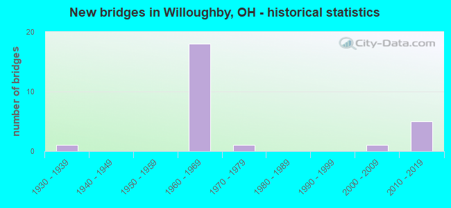
- New bridges - historical statistics
- 11930-1939
- 181960-1969
- 11970-1979
- 12000-2009
- 52010-2019

- Reconstructed bridges - Historical Statistics
- 11970-1979
- 01980-1989
- 01990-1999
- 12000-2009


- Bridge Condition - Deck
- 17.6%Excellent
- 29.4%Very good
- 29.4%Good
- 11.8%Satisfactory
- 5.9%Fair
- 5.9%Poor

- Bridge Condition - Superstructure
- 5.9%Excellent
- 17.6%Very good
- 47.1%Good
- 23.5%Satisfactory
- 5.9%Fair

- Bridge Condition - Substructure
- 29.4%Very good
- 41.2%Good
- 29.4%Satisfactory

- Bridge Condition - Channel
- 37.5%Very good
- 50.0%Good
- 12.5%Satisfactory
Find on map >> Show street view
Structure Number: 4300572, Location: 0.78 MI.E.OF JCT.SR.91 (Lat: 41.642531, Lng: -81.425481), Route carried "on" structure: State highway 2, Year Built: 1962, Status: Open, Structure Length: 6.95m (22.80ft), Average Daily Traffic: 32,506 (year 2015), Truck Traffic: 3%, Average Future Daily Traffic: 45,118 (year 2035), Design Load: HS 20+Mod, Features Intersected: SR-640 (0235) VINE ST.
Minimum Vertical Clearance: 30+ m (98+ ft), Kilometerpoint: 6.437, Lanes on structure: 3, Lanes under structure: 4, Base Highway Network: Yes, Owner: State Highway Agency, Approaching Roadway Width: 16.5m (54.1ft), Skew: 34 degrees, Material/Design: Steel continuous, Design/Construction: Stringer/Multi-beam, Number Of Spans In Main Unit: 3, Length of Maximum Span: 30.8m (101.0ft), Curb-To-Curb Width: 16.5m (54.1ft), Out-to-Out Width: 17.1m (56.1ft)
Condition: Deck: Very good, Superstructure: Good, Substructure: Very good, Operating Rating: 42.1 metric tons, Method Used To Determine Operating Rating: Allowable Stress (AS) rating reported by rating factor (RF) method using MS18 loading, Inventory Rating: 32.4 metric tons, Method Used To Determine Inventory Rating: Allowable Stress (AS) rating reported by rating factor (RF) method using MS18 loading, Structural Evaluation: Better than present minimum criteria, Deck Geometry: Equal to present minimum criteria, Underclear: Meets minimum limits, Approach Roadway Alignment: Equal to present desirable criteria, Designated Inspection Frequency: Every 24 months, Inspection Date: March 2021, Deck Structure Type: Concrete Cast-file-Place, Wearing Surface/Protective System: Wearing Surface: Latex Concrete, Deck Protection: Epoxy Coated Reinforcing
Find on map >> Show street view
Structure Number: 4300602, Location: 0.78 MI.E.OF JCT.SR.91 (Lat: 41.642519, Lng: -81.425081), Route carried "on" structure: State highway 2, Year Built: 1962, Status: Open, Structure Length: 8.50m (27.89ft), Average Daily Traffic: 32,506 (year 2015), Truck Traffic: 3%, Average Future Daily Traffic: 45,118 (year 2035), Design Load: HS 20+Mod, Features Intersected: SR 640 (0237) VINE ST.
Minimum Vertical Clearance: 30+ m (98+ ft), Kilometerpoint: 6.437, Lanes on structure: 3, Lanes under structure: 4, Base Highway Network: Yes, Owner: State Highway Agency, Approaching Roadway Width: 16.5m (54.1ft), Skew: 34 degrees, Material/Design: Steel continuous, Design/Construction: Stringer/Multi-beam, Number Of Spans In Main Unit: 3, Length of Maximum Span: 30.8m (101.0ft), Curb-To-Curb Width: 16.5m (54.1ft), Out-to-Out Width: 17.1m (56.1ft)
Condition: Deck: Very good, Superstructure: Very good, Substructure: Very good, Operating Rating: 42.1 metric tons, Method Used To Determine Operating Rating: Allowable Stress (AS) rating reported by rating factor (RF) method using MS18 loading, Inventory Rating: 32.4 metric tons, Method Used To Determine Inventory Rating: Allowable Stress (AS) rating reported by rating factor (RF) method using MS18 loading, Structural Evaluation: Equal to present desirable criteria, Deck Geometry: Equal to present minimum criteria, Underclear: Meets minimum limits, Approach Roadway Alignment: Equal to present desirable criteria, Designated Inspection Frequency: Every 24 months, Inspection Date: March 2021, Deck Structure Type: Concrete Cast-file-Place, Wearing Surface/Protective System: Wearing Surface: Latex Concrete, Deck Protection: Epoxy Coated Reinforcing
Find on map >> Show street view
Structure Number: 4300637, Location: 0.52 MI.E.OF JCT.SR-640 (Lat: 41.647639, Lng: -81.418600), Route carried "on" structure: City street M0726, Year Built: 1962, Year Reconstructed: 2000, Status: Open, Structure Length: 8.66m (28.41ft), Average Daily Traffic: 1,896 (year 2015), Truck Traffic: 5%, Average Future Daily Traffic: 97,393 (year 2035), Design Load: H 20, Features Intersected: SR 2, Facility Carried by Structure: STEVENS RD
Minimum Vertical Clearance: 30+ m (98+ ft), Kilometerpoint: 3.058, Lanes on structure: 2, Lanes under structure: 4, Owner: State Highway Agency, Approaching Roadway Width: 10.7m (35.1ft), Skew: 3 degrees, Material/Design: Steel continuous, Design/Construction: Stringer/Multi-beam, Number Of Spans In Main Unit: 4, Length of Maximum Span: 22.9m (75.1ft), Curb or Sidewalk Widths: Left: 0.7m (2.3ft), Right: 0.7m (2.3ft), Curb-To-Curb Width: 9.1m (29.9ft), Out-to-Out Width: 11.1m (36.4ft)
Condition: Deck: Satisfactory, Superstructure: Satisfactory, Substructure: Satisfactory, Operating Rating: 32.4 metric tons, Method Used To Determine Operating Rating: Load Factor (LF) rating reported by rating factor (RF) method using MS18 loading, Inventory Rating: 25.9 metric tons, Method Used To Determine Inventory Rating: Load Factor (LF) rating reported by rating factor (RF) method using MS18 loading, Structural Evaluation: Equal to present minimum criteria, Deck Geometry: Somewhat better than minimum adequacy, Underclear: Somewhat better than minimum adequacy, Approach Roadway Alignment: Equal to present desirable criteria, Length Of Structure Improvement: 12.19m (39.99ft), Designated Inspection Frequency: Every 12 months, Inspection Date: March 2021, Bridge Improvement Cost: $720,000, Roadway Improvement Cost: $80,000, Total Project Cost: $800,000, Deck Structure Type: Concrete Cast-file-Place, Wearing Surface/Protective System: Wearing Surface: Monolithic Concrete, Deck Protection: Epoxy Coated Reinforcing
Find on map >> Show street view
Structure Number: 4300718, Location: SR 2 OVER ERIE ROAD (Lat: 41.650889, Lng: -81.412839), Route carried "on" structure: State highway 2, Year Built: 2012, Status: Open, Structure Length: 4.79m (15.72ft), Average Daily Traffic: 70,168 (year 2015), Truck Traffic: 3%, Average Future Daily Traffic: 97,393 (year 2035), Design Load: HS 25 or greater, Features Intersected: ERIE ROAD
Minimum Vertical Clearance: 30+ m (98+ ft), Kilometerpoint: 7.821, Lanes on structure: 7, Lanes under structure: 2, Base Highway Network: Yes, Owner: State Highway Agency, Approaching Roadway Width: 21.9m (71.9ft), Skew: 12 degrees, Material/Design: Steel continuous, Design/Construction: Stringer/Multi-beam, Number Of Spans In Main Unit: 3, Length of Maximum Span: 16.8m (55.1ft), Curb-To-Curb Width: 39.4m (129.3ft), Out-to-Out Width: 41.5m (136.2ft)
Condition: Deck: Very good, Superstructure: Very good, Substructure: Very good, Operating Rating: 68.0 metric tons, Method Used To Determine Operating Rating: Load and Resistance Factor Rating (LRFR) rating reported by rating factor(RF) method using HL-93 loadings, Inventory Rating: 51.8 metric tons, Method Used To Determine Inventory Rating: Load and Resistance Factor Rating (LRFR) rating reported by rating factor(RF) method using HL-93 loadings, Structural Evaluation: Equal to present desirable criteria, Deck Geometry: Superior to present desirable criteria, Underclear: High priority of corrective action, Approach Roadway Alignment: Equal to present desirable criteria, Designated Inspection Frequency: Every 24 months, Inspection Date: Febuary 2021, Deck Structure Type: Concrete Cast-file-Place, Wearing Surface/Protective System: Wearing Surface: Monolithic Concrete, Membrane: Epoxy, Deck Protection: Epoxy Coated Reinforcing
Find on map >> Show street view
Structure Number: 430075, Location: 1.31 MI.E.OF JCCT.SR 640 (Lat: 41.654711, Lng: -81.405800), Route carried "on" structure: State highway 2, Year Built: 1962, Status: Open, Structure Length: 6.89m (22.60ft), Average Daily Traffic: 35,084 (year 2015), Truck Traffic: 3%, Average Future Daily Traffic: 48,697 (year 2035), Design Load: HS 20+Mod, Features Intersected: CHAGRIN RIVER
Minimum Vertical Clearance: 30+ m (98+ ft), Kilometerpoint: 8.530, Lanes on structure: 3, Base Highway Network: Yes, Owner: State Highway Agency, Approaching Roadway Width: 26.6m (87.3ft), Skew: 33 degrees, Material/Design: Steel continuous, Design/Construction: Stringer/Multi-beam, Number Of Spans In Main Unit: 3, Length of Maximum Span: 25.9m (85.0ft), Curb-To-Curb Width: 26.6m (87.3ft), Out-to-Out Width: 28.2m (92.5ft)
Condition: Deck: Excellent, Superstructure: Good, Substructure: Good, Channel: Very good, Operating Rating: 97.2 metric tons, Method Used To Determine Operating Rating: Allowable Stress (AS) rating reported by rating factor (RF) method using MS18 loading, Inventory Rating: 58.3 metric tons, Method Used To Determine Inventory Rating: Allowable Stress (AS) rating reported by rating factor (RF) method using MS18 loading, Structural Evaluation: Better than present minimum criteria, Deck Geometry: Superior to present desirable criteria, Waterway Adequacy: Better than present minimum criteria, Approach Roadway Alignment: Equal to present desirable criteria, Designated Inspection Frequency: Every 24 months, Inspection Date: June 2021, Deck Structure Type: Concrete Cast-file-Place, Wearing Surface/Protective System: Wearing Surface: Latex Concrete, Deck Protection: Epoxy Coated Reinforcing
Find on map >> Show street view
Structure Number: 4300785, Location: 1.31 MI.E.OF JCT.SR 640 (Lat: 41.654500, Lng: -81.405800), Route carried "on" structure: State highway 2, Year Built: 1962, Status: Open, Structure Length: 6.89m (22.60ft), Average Daily Traffic: 35,084 (year 2015), Truck Traffic: 3%, Average Future Daily Traffic: 48,697 (year 2035), Design Load: HS 20, Features Intersected: CHAGRIN RIVER
Minimum Vertical Clearance: 30+ m (98+ ft), Kilometerpoint: 8.530, Lanes on structure: 4, Base Highway Network: Yes, Owner: State Highway Agency, Approaching Roadway Width: 26.6m (87.3ft), Skew: 33 degrees, Material/Design: Steel continuous, Design/Construction: Stringer/Multi-beam, Number Of Spans In Main Unit: 3, Length of Maximum Span: 25.9m (85.0ft), Curb-To-Curb Width: 26.6m (87.3ft), Out-to-Out Width: 28.2m (92.5ft)
Condition: Deck: Excellent, Superstructure: Good, Substructure: Good, Channel: Good, Operating Rating: 97.2 metric tons, Method Used To Determine Operating Rating: Allowable Stress (AS) rating reported by rating factor (RF) method using MS18 loading, Inventory Rating: 64.8 metric tons, Method Used To Determine Inventory Rating: Allowable Stress (AS) rating reported by rating factor (RF) method using MS18 loading, Structural Evaluation: Better than present minimum criteria, Deck Geometry: Superior to present desirable criteria, Waterway Adequacy: Better than present minimum criteria, Approach Roadway Alignment: Equal to present desirable criteria, Designated Inspection Frequency: Every 24 months, Inspection Date: June 2021, Deck Structure Type: Concrete Cast-file-Place, Wearing Surface/Protective System: Wearing Surface: Latex Concrete, Deck Protection: Epoxy Coated Reinforcing
Find on map >> Show street view
Structure Number: 4300807, Location: LST NATN SB RMP TO 2 WB (Lat: 41.654789, Lng: -81.406161), Route carried "on" structure: Ramp State highway 2, Year Built: 2010, Status: Open, Structure Length: 7.42m (24.34ft), Average Daily Traffic: 9,350 (year 2010), Truck Traffic: 5%, Average Future Daily Traffic: 12,978 (year 2030), Design Load: HS 25 or greater, Features Intersected: CHAGRIN RIVER
Minimum Vertical Clearance: 30+ m (98+ ft), Kilometerpoint: 8.530, Lanes on structure: 1, Owner: State Highway Agency, Approaching Roadway Width: 7.6m (24.9ft), Skew: 3 degrees, Material/Design: Steel continuous, Design/Construction: Stringer/Multi-beam, Number Of Spans In Main Unit: 3, Length of Maximum Span: 27.8m (91.2ft), Curb-To-Curb Width: 8.8m (28.9ft), Out-to-Out Width: 9.8m (32.2ft)
Condition: Deck: Excellent, Superstructure: Excellent, Substructure: Good, Channel: Very good, Operating Rating: 77.8 metric tons, Method Used To Determine Operating Rating: Load Factor (LF) rating reported by rating factor (RF) method using MS18 loading, Inventory Rating: 45.4 metric tons, Method Used To Determine Inventory Rating: Load Factor (LF) rating reported by rating factor (RF) method using MS18 loading, Structural Evaluation: Better than present minimum criteria, Deck Geometry: Superior to present desirable criteria, Waterway Adequacy: Better than present minimum criteria, Approach Roadway Alignment: Equal to present desirable criteria, Designated Inspection Frequency: Every 24 months, Inspection Date: June 2021, Deck Structure Type: Concrete Cast-file-Place, Wearing Surface/Protective System: Wearing Surface: Monolithic Concrete, Membrane: Epoxy, Deck Protection: Epoxy Coated Reinforcing
Find on map >> Show street view
Structure Number: 4300823, Location: 1.5 MI WEST OF SR-306 (Lat: 41.655281, Lng: -81.403889), Route carried "on" structure: City street M0715, Year Built: 2010, Status: Open, Structure Length: 7.32m (24.02ft), Average Daily Traffic: 7,316 (year 2015), Truck Traffic: 7%, Average Future Daily Traffic: 79,113 (year 2035), Design Load: HS 25 or greater, Features Intersected: SR - 2, Facility Carried by Structure: LOST NATION ROAD
Minimum Vertical Clearance: 30+ m (98+ ft), Kilometerpoint: 0.821, Lanes on structure: 4, Lanes under structure: 4, Owner: State Highway Agency, Approaching Roadway Width: 20.1m (65.9ft), Material/Design: Steel continuous, Design/Construction: Stringer/Multi-beam, Number Of Spans In Main Unit: 2, Length of Maximum Span: 36.2m (118.8ft), Curb or Sidewalk Widths: Left: 1.8m (5.9ft), Right: 1.8m (5.9ft), Curb-To-Curb Width: 21.3m (69.9ft), Out-to-Out Width: 25.6m (84.0ft)
Condition: Deck: Very good, Superstructure: Good, Substructure: Very good, Operating Rating: 74.5 metric tons, Method Used To Determine Operating Rating: Load Factor (LF) rating reported by rating factor (RF) method using MS18 loading, Inventory Rating: 45.4 metric tons, Method Used To Determine Inventory Rating: Load Factor (LF) rating reported by rating factor (RF) method using MS18 loading, Structural Evaluation: Better than present minimum criteria, Deck Geometry: Superior to present desirable criteria, Underclear: Meets minimum limits, Approach Roadway Alignment: Equal to present desirable criteria, Designated Inspection Frequency: Every 24 months, Inspection Date: Febuary 2021, Deck Structure Type: Concrete Cast-file-Place, Wearing Surface/Protective System: Wearing Surface: Monolithic Concrete, Membrane: Epoxy, Deck Protection: Epoxy Coated Reinforcing
Find on map >> Show street view
Structure Number: 4302095, Location: 1000 FT E SR640 (Lat: 41.642450, Lng: -81.402889), Route carried "on" structure: US 20, Year Built: 1979, Status: Open, Structure Length: 12.65m (41.50ft), Average Daily Traffic: 15,508 (year 2015), Truck Traffic: 6%, Average Future Daily Traffic: 21,525 (year 2035), Design Load: HS 20+Mod, Features Intersected: CHAGRIN RIV 1.58 MIW 306
Minimum Vertical Clearance: 30+ m (98+ ft), Kilometerpoint: 9.205, Lanes on structure: 4, Base Highway Network: Yes, Owner: State Highway Agency, Approaching Roadway Width: 15.9m (52.2ft), Skew: 3 degrees, Material/Design: Prestressed concrete, Design/Construction: Stringer/Multi-beam, Number Of Spans In Main Unit: 4, Length of Maximum Span: 30.8m (101.0ft), Curb or Sidewalk Widths: Left: 2.4m (7.9ft), Right: 2.4m (7.9ft), Curb-To-Curb Width: 15.9m (52.2ft), Out-to-Out Width: 21.3m (69.9ft)
Condition: Deck: Good, Superstructure: Good, Substructure: Good, Channel: Good, Operating Rating: 42.1 metric tons, Method Used To Determine Operating Rating: Allowable Stress (AS) rating reported by rating factor (RF) method using MS18 loading, Inventory Rating: 32.4 metric tons, Method Used To Determine Inventory Rating: Allowable Stress (AS) rating reported by rating factor (RF) method using MS18 loading, Structural Evaluation: Better than present minimum criteria, Deck Geometry: Meets minimum limits, Waterway Adequacy: Equal to present desirable criteria, Approach Roadway Alignment: Equal to present desirable criteria, Designated Inspection Frequency: Every 24 months, Inspection Date: November 2021, Deck Structure Type: Concrete Cast-file-Place, Wearing Surface/Protective System: Wearing Surface: Latex Concrete
Find on map >> Show street view
Structure Number: 4302915, Location: 0.5 MI E SR174 (Lat: 41.630100, Lng: -81.400319), Route carried "on" structure: State highway 84, Year Built: 1931, Year Reconstructed: 1984, Status: Open, Structure Length: 5.91m (19.39ft), Average Daily Traffic: 7,042 (year 2015), Truck Traffic: 2%, Average Future Daily Traffic: 9,774 (year 2035), Design Load: HS 20+Mod, Features Intersected: CHAGRIN R. 1.81 MI W 306
Minimum Vertical Clearance: 30+ m (98+ ft), Kilometerpoint: 10.187, Lanes on structure: 2, Owner: State Highway Agency, Approaching Roadway Width: 12.2m (40.0ft), Skew: 1 degrees, Material/Design: Prestressed concrete continuous, Design/Construction: Box Beam or Girders - Multiple, Number Of Spans In Main Unit: 3, Length of Maximum Span: 19.5m (64.0ft), Curb or Sidewalk Widths: Left: 1.8m (5.9ft), Right: 0.0m, Curb-To-Curb Width: 10.4m (34.1ft), Out-to-Out Width: 12.2m (40.0ft)
Condition: Deck: Fair, Superstructure: Fair, Substructure: Satisfactory, Channel: Satisfactory, Operating Rating: 42.1 metric tons, Method Used To Determine Operating Rating: Load Factor (LF) rating reported by rating factor (RF) method using MS18 loading, Inventory Rating: 32.4 metric tons, Method Used To Determine Inventory Rating: Load Factor (LF) rating reported by rating factor (RF) method using MS18 loading, Structural Evaluation: Somewhat better than minimum adequacy, Deck Geometry: Meets minimum limits, Waterway Adequacy: Equal to present minimum criteria, Approach Roadway Alignment: Equal to present minimum criteria, Designated Inspection Frequency: Every 12 months, Inspection Date: December 2021, Deck Structure Type: Concrete Cast-file-Place, Wearing Surface/Protective System: Wearing Surface: Bituminous
Find on map >> Show street view
Structure Number: 4303784, Location: 1.5 MI. W. SR306 (Lat: 41.627061, Lng: -81.400119), Route carried "on" structure: Interstate 90, Year Built: 1962, Status: Open, Structure Length: 4.11m (13.48ft), Average Daily Traffic: 36,138 (year 2015), Truck Traffic: 10%, Average Future Daily Traffic: 50,160 (year 2035), Design Load: HS 20+Mod, Features Intersected: RIVERSIDE DR @ MP 192.1
Minimum Vertical Clearance: 30+ m (98+ ft), Kilometerpoint: 9.640, Lanes on structure: 3, Lanes under structure: 2, Base Highway Network: Yes, Owner: State Highway Agency, Approaching Roadway Width: 16.5m (54.1ft), Skew: 2 degrees, Material/Design: Steel continuous, Design/Construction: Stringer/Multi-beam, Number Of Spans In Main Unit: 3, Length of Maximum Span: 15.2m (49.9ft), Curb-To-Curb Width: 16.5m (54.1ft), Out-to-Out Width: 17.2m (56.4ft)
Condition: Deck: Good, Superstructure: Good, Substructure: Good, Operating Rating: 42.1 metric tons, Method Used To Determine Operating Rating: Allowable Stress (AS) rating reported by rating factor (RF) method using MS18 loading, Inventory Rating: 32.4 metric tons, Method Used To Determine Inventory Rating: Allowable Stress (AS) rating reported by rating factor (RF) method using MS18 loading, Structural Evaluation: Better than present minimum criteria, Deck Geometry: Equal to present minimum criteria, Underclear: Somewhat better than minimum adequacy, Approach Roadway Alignment: Equal to present desirable criteria, Designated Inspection Frequency: Every 24 months, Inspection Date: March 2021, Deck Structure Type: Concrete Cast-file-Place, Wearing Surface/Protective System: Wearing Surface: Integral Concrete
Find on map >> Show street view
Structure Number: 4303814, Location: 1.5 MI W SR306 (Lat: 41.626389, Lng: -81.399889), Route carried "on" structure: Interstate 90, Year Built: 1962, Status: Open, Structure Length: 4.54m (14.90ft), Average Daily Traffic: 36,138 (year 2015), Truck Traffic: 10%, Average Future Daily Traffic: 50,160 (year 2035), Design Load: HS 20+Mod, Features Intersected: RIVERSIDE DR @ MP 192.1
Minimum Vertical Clearance: 30+ m (98+ ft), Kilometerpoint: 9.640, Lanes on structure: 3, Lanes under structure: 2, Base Highway Network: Yes, Owner: State Highway Agency, Approaching Roadway Width: 16.5m (54.1ft), Skew: 3 degrees, Material/Design: Steel continuous, Design/Construction: Stringer/Multi-beam, Number Of Spans In Main Unit: 3, Length of Maximum Span: 16.8m (55.1ft), Curb-To-Curb Width: 16.5m (54.1ft), Out-to-Out Width: 17.2m (56.4ft)
Condition: Deck: Good, Superstructure: Good, Substructure: Good, Operating Rating: 42.1 metric tons, Method Used To Determine Operating Rating: Allowable Stress (AS) rating reported by rating factor (RF) method using MS18 loading, Inventory Rating: 32.4 metric tons, Method Used To Determine Inventory Rating: Allowable Stress (AS) rating reported by rating factor (RF) method using MS18 loading, Structural Evaluation: Better than present minimum criteria, Deck Geometry: Equal to present minimum criteria, Underclear: Somewhat better than minimum adequacy, Approach Roadway Alignment: Equal to present desirable criteria, Designated Inspection Frequency: Every 24 months, Inspection Date: March 2021, Deck Structure Type: Concrete Cast-file-Place, Wearing Surface/Protective System: Wearing Surface: Low Slump Concrete
Find on map >> Show street view
Structure Number: 4303849, Location: 1.5 MI W SR306 (Lat: 41.627461, Lng: -81.399461), Route carried "on" structure: Interstate 90, Year Built: 1960, Status: Open, Structure Length: 8.93m (29.30ft), Average Daily Traffic: 36,138 (year 2015), Truck Traffic: 10%, Average Future Daily Traffic: 50,160 (year 2035), Design Load: HS 20+Mod, Features Intersected: CHAGRIN RIVER @ MP 192.2
Minimum Vertical Clearance: 30+ m (98+ ft), Kilometerpoint: 9.737, Lanes on structure: 3, Base Highway Network: Yes, Owner: State Highway Agency, Approaching Roadway Width: 16.5m (54.1ft), Skew: 2 degrees, Material/Design: Steel continuous, Design/Construction: Stringer/Multi-beam, Number Of Spans In Main Unit: 4, Length of Maximum Span: 24.4m (80.1ft), Curb-To-Curb Width: 16.5m (54.1ft), Out-to-Out Width: 17.2m (56.4ft)
Condition: Deck: Good, Superstructure: Satisfactory, Substructure: Satisfactory, Channel: Good, Operating Rating: 42.1 metric tons, Method Used To Determine Operating Rating: Allowable Stress (AS) rating reported by rating factor (RF) method using MS18 loading, Inventory Rating: 32.4 metric tons, Method Used To Determine Inventory Rating: Allowable Stress (AS) rating reported by rating factor (RF) method using MS18 loading, Structural Evaluation: Equal to present minimum criteria, Deck Geometry: Equal to present minimum criteria, Waterway Adequacy: Equal to present desirable criteria, Approach Roadway Alignment: Equal to present desirable criteria, Designated Inspection Frequency: Every 12 months, Inspection Date: October 2021, Deck Structure Type: Concrete Cast-file-Place, Wearing Surface/Protective System: Wearing Surface: Low Slump Concrete
Find on map >> Show street view
Structure Number: 4303873, Location: 1.5 MI W SR306 (Lat: 41.627131, Lng: -81.398750), Route carried "on" structure: Interstate 90, Year Built: 1960, Status: Open, Structure Length: 8.93m (29.30ft), Average Daily Traffic: 36,138 (year 2015), Truck Traffic: 10%, Average Future Daily Traffic: 50,160 (year 2035), Design Load: HS 20+Mod, Features Intersected: CHAGRIN RIVER @ MP 192.2
Minimum Vertical Clearance: 30+ m (98+ ft), Kilometerpoint: 9.737, Lanes on structure: 3, Base Highway Network: Yes, Owner: State Highway Agency, Approaching Roadway Width: 16.5m (54.1ft), Skew: 2 degrees, Material/Design: Steel continuous, Design/Construction: Stringer/Multi-beam, Number Of Spans In Main Unit: 4, Length of Maximum Span: 24.4m (80.1ft), Curb-To-Curb Width: 16.5m (54.1ft), Out-to-Out Width: 17.2m (56.4ft)
Condition: Deck: Good, Superstructure: Satisfactory, Substructure: Satisfactory, Channel: Good, Operating Rating: 42.1 metric tons, Method Used To Determine Operating Rating: Allowable Stress (AS) rating reported by rating factor (RF) method using MS18 loading, Inventory Rating: 32.4 metric tons, Method Used To Determine Inventory Rating: Allowable Stress (AS) rating reported by rating factor (RF) method using MS18 loading, Structural Evaluation: Equal to present minimum criteria, Deck Geometry: Equal to present minimum criteria, Waterway Adequacy: Equal to present desirable criteria, Approach Roadway Alignment: Equal to present desirable criteria, Designated Inspection Frequency: Every 12 months, Inspection Date: October 2021, Deck Structure Type: Concrete Cast-file-Place, Wearing Surface/Protective System: Wearing Surface: Low Slump Concrete
Find on map >> Show street view
Structure Number: 4303962, Location: .7 MI W SR 306 (Lat: 41.636450, Lng: -81.383569), Route carried "on" structure: City street M0616, Year Built: 1960, Status: Open, Structure Length: 13.20m (43.31ft), Average Daily Traffic: 8,815 (year 2015), Truck Traffic: 5%, Average Future Daily Traffic: 100,318 (year 2035), Design Load: H 20, Features Intersected: IR 90, Facility Carried by Structure: KIRTLAND RD
Minimum Vertical Clearance: 30+ m (98+ ft), Kilometerpoint: 0.885, Lanes on structure: 2, Lanes under structure: 4, Owner: State Highway Agency, Approaching Roadway Width: 9.1m (29.9ft), Skew: 2 degrees, Material/Design: Steel continuous, Design/Construction: Stringer/Multi-beam, Number Of Spans In Main Unit: 6, Length of Maximum Span: 23.5m (77.1ft), Curb-To-Curb Width: 9.1m (29.9ft), Out-to-Out Width: 11.4m (37.4ft)
Condition: Deck: Satisfactory, Superstructure: Satisfactory, Substructure: Good, Operating Rating: 42.1 metric tons, Method Used To Determine Operating Rating: Load Factor (LF) rating reported by rating factor (RF) method using MS18 loading, Inventory Rating: 32.4 metric tons, Method Used To Determine Inventory Rating: Load Factor (LF) rating reported by rating factor (RF) method using MS18 loading, Structural Evaluation: Equal to present minimum criteria, Deck Geometry: Meets minimum limits, Underclear: Equal to present minimum criteria, Approach Roadway Alignment: Equal to present desirable criteria, Designated Inspection Frequency: Every 12 months, Inspection Date: December 2021, Deck Structure Type: Concrete Cast-file-Place, Wearing Surface/Protective System: Wearing Surface: Integral Concrete, Membrane: Epoxy
Find on map >> Show street view
Structure Number: 4303997, Location: 3.5 MI W SR615 (Lat: 41.640539, Lng: -81.373989), Route carried "on" structure: State highway 306, Year Built: 1962, Status: Open, Structure Length: 12.13m (39.80ft), Average Daily Traffic: 21,309 (year 2015), Truck Traffic: 10%, Average Future Daily Traffic: 29,577 (year 2035), Design Load: HS 20+Mod, Features Intersected: I-90 (BROADMOOR SR 306)
Minimum Vertical Clearance: 30+ m (98+ ft), Kilometerpoint: 8.336, Lanes on structure: 5, Lanes under structure: 4, Base Highway Network: Yes, Owner: State Highway Agency, Approaching Roadway Width: 22.6m (74.1ft), Skew: 20 degrees, Material/Design: Steel continuous, Design/Construction: Stringer/Multi-beam, Number Of Spans In Main Unit: 6, Length of Maximum Span: 21.6m (70.9ft), Curb or Sidewalk Widths: Left: 0.6m (2.0ft), Right: 0.6m (2.0ft), Curb-To-Curb Width: 21.3m (69.9ft), Out-to-Out Width: 23.4m (76.8ft)
Condition: Deck: Poor, Superstructure: Good, Substructure: Satisfactory, Operating Rating: 42.1 metric tons, Method Used To Determine Operating Rating: Allowable Stress (AS) rating reported by rating factor (RF) method using MS18 loading, Inventory Rating: 32.4 metric tons, Method Used To Determine Inventory Rating: Allowable Stress (AS) rating reported by rating factor (RF) method using MS18 loading, Structural Evaluation: Equal to present minimum criteria, Deck Geometry: Somewhat better than minimum adequacy, Underclear: Equal to present minimum criteria, Approach Roadway Alignment: Equal to present desirable criteria, Designated Inspection Frequency: Every 12 months, Inspection Date: December 2021, Deck Structure Type: Concrete Cast-file-Place, Wearing Surface/Protective System: Wearing Surface: Latex Concrete, Membrane: Epoxy
Find on map >> Show street view
Structure Number: 435213, Location: 0.72 MI NE OF RT 20 (Lat: 41.651661, Lng: -81.405039), Route carried "on" structure: County highway C504A, Year Built: 2007, Status: Open, Structure Length: 5.94m (19.49ft), Average Daily Traffic: 7,316 (year 2015), Truck Traffic: 7%, Average Future Daily Traffic: 10,155 (year 2035), Design Load: HS 20+Mod, Features Intersected: CHAGRIN RIVER, Facility Carried by Structure: GILSON PARKWAY
Minimum Vertical Clearance: 30+ m (98+ ft), Kilometerpoint: 0.161, Lanes on structure: 2, Owner: County Highway Agency, Approaching Roadway Width: 12.2m (40.0ft), Skew: 2 degrees, Material/Design: Steel continuous, Design/Construction: Stringer/Multi-beam, Number Of Spans In Main Unit: 2, Length of Maximum Span: 29.9m (98.1ft), Curb or Sidewalk Widths: Left: 0.2m (0.7ft), Right: 0.2m (0.7ft), Curb-To-Curb Width: 12.2m (40.0ft), Out-to-Out Width: 15.9m (52.2ft)
Condition: Deck: Very good, Superstructure: Very good, Substructure: Very good, Channel: Very good, Operating Rating: 58.3 metric tons, Method Used To Determine Operating Rating: Load Factor (LF) rating reported by rating factor (RF) method using MS18 loading, Inventory Rating: 35.6 metric tons, Method Used To Determine Inventory Rating: Load Factor (LF) rating reported by rating factor (RF) method using MS18 loading, Structural Evaluation: Equal to present desirable criteria, Deck Geometry: Somewhat better than minimum adequacy, Waterway Adequacy: Better than present minimum criteria, Approach Roadway Alignment: Superior to present desirable criteria, Designated Inspection Frequency: Every 24 months, Inspection Date: November 2021, Deck Structure Type: Concrete Cast-file-Place, Wearing Surface/Protective System: Wearing Surface: Monolithic Concrete, Deck Protection: Epoxy Coated Reinforcing
Find on map >> Show street view
Structure Number: 4300572, Location: 0.78 MI.E.OF JCT.SR.91 (Lat: 41.642531, Lng: -81.425481), Route carried "under" structure: State highway 640, Year Built: 1962, Structure Length: 0. m, Average Daily Traffic: 15,120 (year 2015), Truck Traffic: 8%, Features Intersected: SR-2 (LAK-2-0400L), Facility Carried by Structure: SR 2
Minimum Vertical Clearance: 4.80m (15.75ft), Kilometerpoint: 3.782, Lanes on structure: 3, Lanes under structure: 4, Material/Design: Steel continuous, Design/Construction: Stringer/Multi-beam, Length of Maximum Span: 30.8m (101.0ft)
Find on map >> Show street view
Structure Number: 4300602, Location: 0.78 MI.E.OF JCT.SR.91 (Lat: 41.642519, Lng: -81.425081), Route carried "under" structure: State highway 640, Year Built: 1962, Structure Length: 0. m, Average Daily Traffic: 15,120 (year 2015), Truck Traffic: 8%, Features Intersected: SR-2 (LAK-2-0400R), Facility Carried by Structure: SR 2
Minimum Vertical Clearance: 4.90m (16.08ft), Kilometerpoint: 3.814, Lanes on structure: 3, Lanes under structure: 4, Material/Design: Steel continuous, Design/Construction: Stringer/Multi-beam, Length of Maximum Span: 30.8m (101.0ft)
Find on map >> Show street view
Structure Number: 4300637, Location: 0.52 MI.E.OF JCT.SR-640 (Lat: 41.647639, Lng: -81.418600), Route carried "under" structure: State highway 2, Year Built: 1962, Structure Length: 0. m, Average Daily Traffic: 70,168 (year 2015), Truck Traffic: 3%, Features Intersected: STEVENS RD, Facility Carried by Structure: STEVENS RD
Minimum Vertical Clearance: 5.97m (19.59ft), Kilometerpoint: 7.258, Lanes on structure: 2, Lanes under structure: 4, Material/Design: Steel continuous, Design/Construction: Stringer/Multi-beam, Length of Maximum Span: 22.9m (75.1ft)
Find on map >> Show street view
Structure Number: 4300718, Location: SR 2 OVER ERIE ROAD (Lat: 41.650889, Lng: -81.412839), Route carried "under" structure: City street 719, Year Built: 2012, Structure Length: 0. m, Average Daily Traffic: 4,185 (year 2015), Truck Traffic: 5%, Features Intersected: SR 2, Facility Carried by Structure: SR 2
Minimum Vertical Clearance: 4.88m (16.01ft), Kilometerpoint: 3.122, Lanes on structure: 7, Lanes under structure: 2, Material/Design: Steel continuous, Design/Construction: Stringer/Multi-beam, Length of Maximum Span: 16.8m (55.1ft)
Find on map >> Show street view
Structure Number: 4300823, Location: 1.5 MI WEST OF SR-306 (Lat: 41.655281, Lng: -81.403889), Route carried "under" structure: State highway 4, Year Built: 2010, Structure Length: 0. m, Average Daily Traffic: 56,998 (year 2015), Truck Traffic: 3%, Features Intersected: LOST NATION ROAD, Facility Carried by Structure: LOST NATION ROAD
Minimum Vertical Clearance: 5.31m (17.42ft), Kilometerpoint: 8.723, Lanes on structure: 4, Lanes under structure: 4, Material/Design: Steel continuous, Design/Construction: Stringer/Multi-beam, Length of Maximum Span: 36.2m (118.8ft)
Find on map >> Show street view
Structure Number: 4303784, Location: 1.5 MI. W. SR306 (Lat: 41.627061, Lng: -81.400119), Route carried "under" structure: City street RIVSD, Year Built: 1962, Structure Length: 0. m, Average Daily Traffic: 1,000 (year 1973), Features Intersected: I-90, Facility Carried by Structure: I-90
Minimum Vertical Clearance: 4.62m (15.16ft), Kilometerpoint: 0.193, Lanes on structure: 3, Lanes under structure: 2, Material/Design: Steel continuous, Design/Construction: Stringer/Multi-beam, Length of Maximum Span: 15.2m (49.9ft)
Find on map >> Show street view
Structure Number: 4303814, Location: 1.5 MI W SR306 (Lat: 41.626389, Lng: -81.399889), Route carried "under" structure: City street RIVSD, Year Built: 1962, Structure Length: 0. m, Average Daily Traffic: 1,000 (year 1973), Features Intersected: I-90, Facility Carried by Structure: INTERST. 90
Minimum Vertical Clearance: 4.52m (14.83ft), Kilometerpoint: 0.193, Lanes on structure: 3, Lanes under structure: 2, Material/Design: Steel continuous, Design/Construction: Stringer/Multi-beam, Length of Maximum Span: 16.8m (55.1ft)
Find on map >> Show street view
Structure Number: 4303962, Location: .7 MI W SR 306 (Lat: 41.636450, Lng: -81.383569), Route carried "under" structure: Interstate 90, Year Built: 1960, Structure Length: 0. m, Average Daily Traffic: 72,275 (year 2015), Truck Traffic: 10%, Features Intersected: KIRTLAND RD, Facility Carried by Structure: KIRTLAND RD
Minimum Vertical Clearance: 5.62m (18.44ft), Kilometerpoint: 11.442, Lanes on structure: 2, Lanes under structure: 4, Material/Design: Steel continuous, Design/Construction: Stringer/Multi-beam, Length of Maximum Span: 23.5m (77.1ft)
Find on map >> Show street view
Structure Number: 4303997, Location: 3.5 MI W SR615 (Lat: 41.640539, Lng: -81.373989), Route carried "under" structure: Interstate 90, Year Built: 1962, Structure Length: 0. m, Average Daily Traffic: 54,352 (year 2015), Truck Traffic: 10%, Features Intersected: SR-306 (LAK-306-0518), Facility Carried by Structure: SR 306
Minimum Vertical Clearance: 5.10m (16.73ft), Kilometerpoint: 12.344, Lanes on structure: 5, Lanes under structure: 4, Material/Design: Steel continuous, Design/Construction: Stringer/Multi-beam, Length of Maximum Span: 21.6m (70.9ft)