Bridge Statistics for Williamsburg, Florida (FL)
Condition, Traffic, Stress, Structural Evaluation, Project Costs
- National Bridge Inventory (NBI) Statistics
- 25Number of bridges
- 240ft / 72.9mTotal length
- 823,602Total average daily traffic
- 53,066Total average daily truck traffic
- National Bridge Inventory (NBI) Registered Bridges for Williamsburg
- No street view available for this location
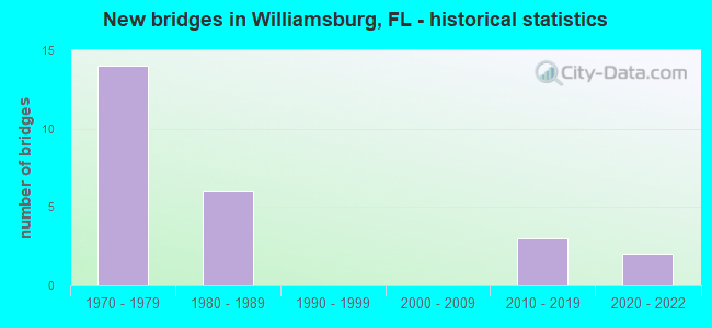
- New bridges - historical statistics
- 141970-1979
- 61980-1989
- 32010-2019
- 22020-2022


- Bridge Condition - Deck
- 7.7%Excellent
- 76.9%Good
- 7.7%Satisfactory
- 7.7%Fair

- Bridge Condition - Superstructure
- 7.7%Excellent
- 46.2%Good
- 38.5%Satisfactory
- 7.7%Fair

- Bridge Condition - Substructure
- 7.7%Excellent
- 92.3%Good

- Bridge Condition - Channel
- 11.1%Excellent
- 44.4%Very good
- 44.4%Good

- Bridge Condition - Culverts
- 33.3%Very good
- 66.7%Good
Find on map >> Show street view
Structure Number: 110116, Location: Wekiva Pkwy - Wekiva Rd (Lat: 28.426111, Lng: -81.426111), Route carried "on" structure: Other road 429, Year Built: 2021, Status: Not yet open, Structure Length: 2.87m (9.42ft), Average Daily Traffic: 26,500 (year 2020), Truck Traffic: 13%, Average Future Daily Traffic: 45,978 (year 2042), Design Load: HL 93, Features Intersected: Wekiva River Rd, Facility Carried by Structure: Wekiva Pkwy WB
Minimum Vertical Clearance: 30+ m (98+ ft), Kilometerpoint: 22.531, Lanes on structure: 2, Lanes under structure: 2, Base Highway Network: Yes, Toll: On toll road, Owner: State Highway Agency, Approaching Roadway Width: 13.4m (44.0ft), Material/Design: Prestressed concrete, Design/Construction: Stringer/Multi-beam, Number Of Spans In Main Unit: 1, Length of Maximum Span: 28.7m (94.2ft), Curb-To-Curb Width: 13.4m (44.0ft), Out-to-Out Width: 14.3m (46.9ft)
Condition: Deck: Excellent, Superstructure: Excellent, Substructure: Excellent, Operating Rating: 47.7 metric tons, Method Used To Determine Operating Rating: Load and Resistance Factor (LRFR), Inventory Rating: 33.7 metric tons, Method Used To Determine Inventory Rating: Load and Resistance Factor (LRFR), Structural Evaluation: Superior to present desirable criteria, Deck Geometry: Equal to present minimum criteria, Underclear: Superior to present desirable criteria, Approach Roadway Alignment: Equal to present desirable criteria, Designated Inspection Frequency: Every 24 months, Inspection Date: January 2022, Deck Structure Type: Concrete Cast-file-Place, Wearing Surface/Protective System: Wearing Surface: Monolithic Concrete
Find on map >> Show street view
Structure Number: 750088, Location: 0.9 MI EAST OF I-4 (Lat: 28.421103, Lng: -81.459914), Route carried "on" structure: State highway 528, Year Built: 1973, Year Reconstructed: 2019, Status: Open, Structure Length: 5.96m (19.55ft), Average Daily Traffic: 40,950 (year 2020), Truck Traffic: 12%, Average Future Daily Traffic: 71,048 (year 2042), Design Load: HL 93, Features Intersected: INTERNATIONAL DRIVE
Minimum Vertical Clearance: 30+ m (98+ ft), Kilometerpoint: 1.349, Lanes on structure: 4, Lanes under structure: 7, Base Highway Network: Yes, Toll: On toll road, Owner: State Toll Authority, Approaching Roadway Width: 20.7m (67.9ft), Material/Design: Prestressed concrete, Design/Construction: Stringer/Multi-beam, Number Of Spans In Main Unit: 2, Length of Maximum Span: 32.7m (107.3ft), Curb-To-Curb Width: 25.9m (85.0ft), Out-to-Out Width: 26.5m (86.9ft)
Condition: Deck: Good, Superstructure: Good, Substructure: Good, Operating Rating: 51.8 metric tons, Method Used To Determine Operating Rating: Load and Resistance Factor (LRFR), Inventory Rating: 36.0 metric tons, Method Used To Determine Inventory Rating: Load and Resistance Factor (LRFR), Structural Evaluation: Better than present minimum criteria, Deck Geometry: Superior to present desirable criteria, Underclear: Somewhat better than minimum adequacy, Approach Roadway Alignment: Equal to present desirable criteria, Designated Inspection Frequency: Every 24 months, Inspection Date: December 2021, Deck Structure Type: Concrete Cast-file-Place
Find on map >> Show street view
Structure Number: 750089, Location: 1.9 MI EAST OF I-4 (Lat: 28.421217, Lng: -81.442703), Route carried "on" structure: State highway 528, Year Built: 1973, Year Reconstructed: 2019, Status: Open, Structure Length: 6.17m (20.24ft), Average Daily Traffic: 41,350 (year 2020), Truck Traffic: 12%, Average Future Daily Traffic: 71,742 (year 2042), Design Load: HL 93, Features Intersected: UNIVERSAL BLVD
Minimum Vertical Clearance: 30+ m (98+ ft), Kilometerpoint: 3.034, Lanes on structure: 5, Lanes under structure: 6, Base Highway Network: Yes, Toll: On toll road, Owner: State Toll Authority, Approaching Roadway Width: 26.5m (86.9ft), Material/Design: Prestressed concrete, Design/Construction: Stringer/Multi-beam, Number Of Spans In Main Unit: 2, Length of Maximum Span: 30.8m (101.0ft), Curb-To-Curb Width: 25.6m (84.0ft), Out-to-Out Width: 26.5m (86.9ft)
Condition: Deck: Good, Superstructure: Satisfactory, Substructure: Good, Operating Rating: 54.7 metric tons, Method Used To Determine Operating Rating: Load and Resistance Factor (LRFR), Inventory Rating: 39.2 metric tons, Method Used To Determine Inventory Rating: Load and Resistance Factor (LRFR), Structural Evaluation: Equal to present minimum criteria, Deck Geometry: Better than present minimum criteria, Underclear: High priority of corrective action, Approach Roadway Alignment: Equal to present desirable criteria, Designated Inspection Frequency: Every 24 months, Inspection Date: December 2021, Deck Structure Type: Concrete Cast-file-Place
Find on map >> Show street view
Structure Number: 750091, Location: 3.1 MI EAST OF SR 400 I-4 (Lat: 28.422042, Lng: -81.422831), Route carried "on" structure: State highway 528, Year Built: 1973, Year Reconstructed: 2019, Status: Open, Structure Length: 8.84m (29.00ft), Average Daily Traffic: 44,900 (year 2020), Truck Traffic: 12%, Average Future Daily Traffic: 77,902 (year 2042), Design Load: HL 93, Features Intersected: CR 423 JOHN YOUNG PKWY
Minimum Vertical Clearance: 30+ m (98+ ft), Kilometerpoint: 4.986, Lanes on structure: 4, Lanes under structure: 9, Base Highway Network: Yes, Toll: On toll road, Owner: State Toll Authority, Approaching Roadway Width: 22.9m (75.1ft), Skew: 2 degrees, Material/Design: Prestressed concrete, Design/Construction: Stringer/Multi-beam, Number Of Spans In Main Unit: 4, Length of Maximum Span: 26.9m (88.3ft), Curb-To-Curb Width: 22.6m (74.1ft), Out-to-Out Width: 23.5m (77.1ft)
Condition: Deck: Good, Superstructure: Satisfactory, Substructure: Good, Operating Rating: 57.4 metric tons, Method Used To Determine Operating Rating: Load and Resistance Factor (LRFR), Inventory Rating: 40.4 metric tons, Method Used To Determine Inventory Rating: Load and Resistance Factor (LRFR), Structural Evaluation: Equal to present minimum criteria, Deck Geometry: Superior to present desirable criteria, Underclear: Meets minimum limits, Approach Roadway Alignment: Equal to present desirable criteria, Designated Inspection Frequency: Every 24 months, Inspection Date: December 2021, Deck Structure Type: Concrete Cast-file-Place
Find on map >> Show street view
Structure Number: 750215, Location: 0.9 MI EAST OF I-4 (Lat: 28.420883, Lng: -81.459900), Route carried "on" structure: State highway 528, Year Built: 1973, Year Reconstructed: 2019, Status: Open, Structure Length: 5.39m (17.68ft), Average Daily Traffic: 40,950 (year 2020), Truck Traffic: 12%, Average Future Daily Traffic: 71,048 (year 2042), Design Load: HL 93, Features Intersected: INTERNATIONAL DR
Minimum Vertical Clearance: 30+ m (98+ ft), Kilometerpoint: 1.349, Lanes on structure: 5, Lanes under structure: 7, Base Highway Network: Yes, Toll: On toll road, Owner: State Toll Authority, Approaching Roadway Width: 20.7m (67.9ft), Material/Design: Prestressed concrete, Design/Construction: Stringer/Multi-beam, Number Of Spans In Main Unit: 2, Length of Maximum Span: 27.0m (88.6ft), Curb-To-Curb Width: 25.9m (85.0ft), Out-to-Out Width: 26.5m (86.9ft)
Condition: Deck: Good, Superstructure: Satisfactory, Substructure: Good, Operating Rating: 53.8 metric tons, Method Used To Determine Operating Rating: Load and Resistance Factor (LRFR), Inventory Rating: 39.7 metric tons, Method Used To Determine Inventory Rating: Load and Resistance Factor (LRFR), Structural Evaluation: Equal to present minimum criteria, Deck Geometry: Superior to present desirable criteria, Underclear: Somewhat better than minimum adequacy, Approach Roadway Alignment: Equal to present desirable criteria, Designated Inspection Frequency: Every 24 months, Inspection Date: December 2021, Deck Structure Type: Concrete Cast-file-Place
Find on map >> Show street view
Structure Number: 750216, Location: 1.9 MI EAST OF I-4 (Lat: 28.421019, Lng: -81.442706), Route carried "on" structure: State highway 528, Year Built: 1973, Year Reconstructed: 2019, Status: Open, Structure Length: 6.17m (20.24ft), Average Daily Traffic: 41,350 (year 2020), Truck Traffic: 12%, Average Future Daily Traffic: 71,742 (year 2042), Design Load: HL 93, Features Intersected: UNIVERSAL BLVD
Minimum Vertical Clearance: 30+ m (98+ ft), Kilometerpoint: 3.034, Lanes on structure: 5, Lanes under structure: 6, Base Highway Network: Yes, Toll: On toll road, Owner: State Toll Authority, Approaching Roadway Width: 27.0m (88.6ft), Material/Design: Prestressed concrete, Design/Construction: Stringer/Multi-beam, Number Of Spans In Main Unit: 2, Length of Maximum Span: 30.8m (101.0ft), Curb-To-Curb Width: 25.6m (84.0ft), Out-to-Out Width: 26.5m (86.9ft)
Condition: Deck: Good, Superstructure: Satisfactory, Substructure: Good, Operating Rating: 54.6 metric tons, Method Used To Determine Operating Rating: Load and Resistance Factor (LRFR), Inventory Rating: 35.5 metric tons, Method Used To Determine Inventory Rating: Load and Resistance Factor (LRFR), Structural Evaluation: Equal to present minimum criteria, Deck Geometry: Better than present minimum criteria, Underclear: Equal to present minimum criteria, Approach Roadway Alignment: Equal to present desirable criteria, Designated Inspection Frequency: Every 24 months, Inspection Date: December 2021, Deck Structure Type: Concrete Cast-file-Place
Find on map >> Show street view
Structure Number: 750218, Location: 3.1 MI EAST OF SR 400 I-4 (Lat: 28.421825, Lng: -81.422828), Route carried "on" structure: State highway 528, Year Built: 1973, Year Reconstructed: 2019, Status: Open, Structure Length: 8.84m (29.00ft), Average Daily Traffic: 44,900 (year 2020), Truck Traffic: 12%, Average Future Daily Traffic: 77,902 (year 2042), Design Load: HL 93, Features Intersected: CR 423 JOHN YOUNG PKWY
Minimum Vertical Clearance: 30+ m (98+ ft), Kilometerpoint: 4.976, Lanes on structure: 4, Lanes under structure: 8, Base Highway Network: Yes, Toll: On toll road, Owner: State Toll Authority, Approaching Roadway Width: 22.9m (75.1ft), Skew: 2 degrees, Material/Design: Prestressed concrete, Design/Construction: Stringer/Multi-beam, Number Of Spans In Main Unit: 4, Length of Maximum Span: 26.9m (88.3ft), Curb-To-Curb Width: 22.1m (72.5ft), Out-to-Out Width: 23.5m (77.1ft)
Condition: Deck: Satisfactory, Superstructure: Satisfactory, Substructure: Good, Operating Rating: 57.5 metric tons, Method Used To Determine Operating Rating: Load and Resistance Factor (LRFR), Inventory Rating: 36.4 metric tons, Method Used To Determine Inventory Rating: Load and Resistance Factor (LRFR), Structural Evaluation: Equal to present minimum criteria, Deck Geometry: Equal to present desirable criteria, Underclear: Meets minimum limits, Approach Roadway Alignment: Equal to present desirable criteria, Designated Inspection Frequency: Every 24 months, Inspection Date: December 2021, Deck Structure Type: Concrete Cast-file-Place
Find on map >> Show street view
Structure Number: 754069, Location: 0.6 mi W of John Young Pk (Lat: 28.410392, Lng: -81.433608), Route carried "on" structure: County highway , Year Built: 1987, Status: Open, Structure Length: 7.32m (24.02ft), Average Daily Traffic: 27,500 (year 2021), Truck Traffic: 4%, Average Future Daily Traffic: 47,713 (year 2042), Design Load: HS 20, Features Intersected: Shingle Creek, Facility Carried by Structure: Central Fl Pkwy WB
Minimum Vertical Clearance: 30+ m (98+ ft), Kilometerpoint: 4.413, Lanes on structure: 2, Owner: County Highway Agency, Approaching Roadway Width: 7.2m (23.6ft), Material/Design: Prestressed concrete, Design/Construction: Slab, Number Of Spans In Main Unit: 6, Length of Maximum Span: 12.2m (40.0ft), Curb or Sidewalk Widths: Left: 1.6m (5.2ft), Right: 0.0m, Curb-To-Curb Width: 12.2m (40.0ft), Out-to-Out Width: 14.6m (47.9ft)
Condition: Deck: Good, Superstructure: Good, Substructure: Good, Channel: Good, Operating Rating: 72.5 metric tons, Method Used To Determine Operating Rating: Allowable Stress (AS), Inventory Rating: 58.5 metric tons, Method Used To Determine Inventory Rating: Allowable Stress (AS), Structural Evaluation: Better than present minimum criteria, Deck Geometry: Better than present minimum criteria, Waterway Adequacy: Superior to present desirable criteria, Approach Roadway Alignment: Equal to present desirable criteria, Designated Inspection Frequency: Every 24 months, Underwater Inspection Frequency: Every 24 months, Inspection Date: October 2021, Underwater Inspection Date: October 2021, Deck Structure Type: Concrete Precast Panels, Wearing Surface/Protective System: Wearing Surface: Bituminous
Find on map >> Show street view
Structure Number: 754083, Location: 0.3 mi N. Central Fl Pkwy (Lat: 28.413453, Lng: -81.423147), Route carried "on" structure: County highway 423, Year Built: 1989, Status: Open, Structure Length: 3.79m (12.43ft), Average Daily Traffic: 77,000 (year 2021), Truck Traffic: 2%, Average Future Daily Traffic: 133,595 (year 2042), Design Load: HS 20, Features Intersected: Valencia Canal #12, Facility Carried by Structure: John Young Pkwy SB
Minimum Vertical Clearance: 30+ m (98+ ft), Kilometerpoint: 7.416, Lanes on structure: 3, Owner: County Highway Agency, Approaching Roadway Width: 13.0m (42.7ft), Material/Design: Prestressed concrete, Design/Construction: Slab, Number Of Spans In Main Unit: 3, Length of Maximum Span: 12.6m (41.3ft), Curb or Sidewalk Widths: Left: 1.8m (5.9ft), Right: 0.0m, Curb-To-Curb Width: 17.6m (57.7ft), Out-to-Out Width: 20.7m (67.9ft)
Condition: Deck: Fair, Superstructure: Fair, Substructure: Good, Channel: Very good, Inventory Rating: 72.3 metric tons, Method Used To Determine Inventory Rating: Allowable Stress (AS), Structural Evaluation: Somewhat better than minimum adequacy, Deck Geometry: Superior to present desirable criteria, Waterway Adequacy: Superior to present desirable criteria, Approach Roadway Alignment: Equal to present desirable criteria, Designated Inspection Frequency: Every 24 months, Underwater Inspection Frequency: Every 24 months, Inspection Date: October 2021, Underwater Inspection Date: October 2021, Deck Structure Type: Concrete Precast Panels, Wearing Surface/Protective System: Wearing Surface: Bituminous
Find on map >> Show street view
Structure Number: 754084, Location: 1.3 Mi S of Cntrl Fl Pkwy (Lat: 28.391869, Lng: -81.425200), Route carried "on" structure: County highway 423, Year Built: 1989, Status: Open, Structure Length: 1.28m (4.20ft), Average Daily Traffic: 77,000 (year 2021), Truck Traffic: 2%, Average Future Daily Traffic: 133,595 (year 2042), Design Load: HS 20, Features Intersected: Shingle Creek, Facility Carried by Structure: John Young Pkwy SB
Minimum Vertical Clearance: 30+ m (98+ ft), Kilometerpoint: 4.992, Lanes on structure: 3, Owner: County Highway Agency, Approaching Roadway Width: 11.1m (36.4ft), Material/Design: Prestressed concrete, Design/Construction: Slab, Number Of Spans In Main Unit: 1, Length of Maximum Span: 12.8m (42.0ft), Curb or Sidewalk Widths: Left: 1.8m (5.9ft), Right: 0.0m, Curb-To-Curb Width: 18.0m (59.1ft), Out-to-Out Width: 20.8m (68.2ft)
Condition: Deck: Good, Superstructure: Good, Substructure: Good, Channel: Good, Inventory Rating: 79.7 metric tons, Method Used To Determine Inventory Rating: Allowable Stress (AS), Structural Evaluation: Better than present minimum criteria, Deck Geometry: Superior to present desirable criteria, Waterway Adequacy: Superior to present desirable criteria, Approach Roadway Alignment: Equal to present desirable criteria, Designated Inspection Frequency: Every 24 months, Inspection Date: October 2021, Deck Structure Type: Concrete Precast Panels, Wearing Surface/Protective System: Wearing Surface: Bituminous
Find on map >> Show street view
Structure Number: 754085, Location: 0.6 Mi W of Jhn Young Pky (Lat: 28.410228, Lng: -81.433606), Route carried "on" structure: County highway , Year Built: 1989, Status: Open, Structure Length: 7.32m (24.02ft), Average Daily Traffic: 27,500 (year 2021), Truck Traffic: 4%, Average Future Daily Traffic: 47,713 (year 2042), Design Load: HS 20, Features Intersected: Shingle Creek, Facility Carried by Structure: Central Fl Pkwy EB
Minimum Vertical Clearance: 30+ m (98+ ft), Kilometerpoint: 4.413, Lanes on structure: 2, Owner: County Highway Agency, Approaching Roadway Width: 7.8m (25.6ft), Material/Design: Prestressed concrete, Design/Construction: Slab, Number Of Spans In Main Unit: 6, Length of Maximum Span: 12.2m (40.0ft), Curb or Sidewalk Widths: Left: 0.0m, Right: 1.5m (4.9ft), Curb-To-Curb Width: 12.2m (40.0ft), Out-to-Out Width: 14.6m (47.9ft)
Condition: Deck: Good, Superstructure: Good, Substructure: Good, Channel: Good, Operating Rating: 46.1 metric tons, Method Used To Determine Operating Rating: Allowable Stress (AS), Inventory Rating: 30.4 metric tons, Method Used To Determine Inventory Rating: Allowable Stress (AS), Structural Evaluation: Better than present minimum criteria, Deck Geometry: Better than present minimum criteria, Waterway Adequacy: Superior to present desirable criteria, Approach Roadway Alignment: Equal to present desirable criteria, Designated Inspection Frequency: Every 24 months, Underwater Inspection Frequency: Every 24 months, Inspection Date: October 2021, Underwater Inspection Date: October 2021, Deck Structure Type: Concrete Precast Panels, Wearing Surface/Protective System: Wearing Surface: Bituminous
Find on map >> Show street view
Structure Number: 754092, Location: 1.3 Mi S of Cntrl FL Pkwy (Lat: 28.391864, Lng: -81.424919), Route carried "on" structure: County highway 423, Year Built: 1989, Status: Open, Structure Length: 1.28m (4.20ft), Average Daily Traffic: 77,000 (year 2021), Truck Traffic: 2%, Average Future Daily Traffic: 133,595 (year 2042), Design Load: HS 20, Features Intersected: Shingle Creek, Facility Carried by Structure: John Young Pkwy NB
Minimum Vertical Clearance: 30+ m (98+ ft), Kilometerpoint: 4.992, Lanes on structure: 3, Owner: County Highway Agency, Approaching Roadway Width: 11.3m (37.1ft), Material/Design: Prestressed concrete, Design/Construction: Slab, Number Of Spans In Main Unit: 1, Length of Maximum Span: 12.8m (42.0ft), Curb or Sidewalk Widths: Left: 0.0m, Right: 1.8m (5.9ft), Curb-To-Curb Width: 18.0m (59.1ft), Out-to-Out Width: 20.8m (68.2ft)
Condition: Deck: Good, Superstructure: Good, Substructure: Good, Channel: Good, Inventory Rating: 79.7 metric tons, Method Used To Determine Inventory Rating: Allowable Stress (AS), Structural Evaluation: Better than present minimum criteria, Deck Geometry: Superior to present desirable criteria, Waterway Adequacy: Superior to present desirable criteria, Approach Roadway Alignment: Equal to present desirable criteria, Designated Inspection Frequency: Every 24 months, Inspection Date: October 2021, Deck Structure Type: Concrete Precast Panels, Wearing Surface/Protective System: Wearing Surface: Bituminous
Find on map >> Show street view
Structure Number: 754093, Location: 0.3 mi N. Central Fl Pkwy (Lat: 28.413406, Lng: -81.422867), Route carried "on" structure: County highway 423, Year Built: 1989, Status: Open, Structure Length: 3.79m (12.43ft), Average Daily Traffic: 77,000 (year 2021), Truck Traffic: 2%, Average Future Daily Traffic: 133,595 (year 2042), Design Load: HS 20, Features Intersected: Valencia Canal #12, Facility Carried by Structure: John Young Pkwy NB
Minimum Vertical Clearance: 30+ m (98+ ft), Kilometerpoint: 7.416, Lanes on structure: 3, Owner: County Highway Agency, Approaching Roadway Width: 12.8m (42.0ft), Material/Design: Prestressed concrete, Design/Construction: Slab, Number Of Spans In Main Unit: 3, Length of Maximum Span: 12.6m (41.3ft), Curb or Sidewalk Widths: Left: 0.0m, Right: 1.8m (5.9ft), Curb-To-Curb Width: 17.6m (57.7ft), Out-to-Out Width: 20.7m (67.9ft)
Condition: Deck: Good, Superstructure: Good, Substructure: Good, Channel: Very good, Inventory Rating: 72.3 metric tons, Method Used To Determine Inventory Rating: Allowable Stress (AS), Structural Evaluation: Better than present minimum criteria, Deck Geometry: Superior to present desirable criteria, Waterway Adequacy: Superior to present desirable criteria, Approach Roadway Alignment: Equal to present desirable criteria, Designated Inspection Frequency: Every 24 months, Underwater Inspection Frequency: Every 24 months, Inspection Date: October 2021, Underwater Inspection Date: October 2021, Deck Structure Type: Concrete Precast Panels, Wearing Surface/Protective System: Wearing Surface: Bituminous
Find on map >> Show street view
Structure Number: 75415, Location: .5 mi W of Univ. Blvd (Lat: 28.424094, Lng: -81.449725), Route carried "on" structure: State highway , Year Built: 2019, Status: Open, Structure Length: 1.07m (3.51ft), Average Daily Traffic: 101 (year 2021), Truck Traffic: 5%, Average Future Daily Traffic: 171 (year 2042), Design Load: HL 93, Features Intersected: Canal, Facility Carried by Structure: Destination Pkwy
Minimum Vertical Clearance: 30+ m (98+ ft), Kilometerpoint: 0.000, Lanes on structure: 4, Owner: County Highway Agency, Approaching Roadway Width: 15.8m (51.8ft), Skew: 12 degrees, Material/Design: Concrete, Design/Construction: Culvert, Number Of Spans In Main Unit: 3, Length of Maximum Span: 3.0m (9.8ft)
Condition: Channel: Very good, Culverts: Good, Structural Evaluation: Better than present minimum criteria, Waterway Adequacy: Equal to present desirable criteria, Approach Roadway Alignment: Equal to present desirable criteria, Designated Inspection Frequency: Every 24 months, Underwater Inspection Frequency: Every 24 months, Inspection Date: April 2021, Underwater Inspection Date: April 2021
Find on map >> Show street view
Structure Number: 754151, Location: .3 mi W of Universal Blvd (Lat: 28.425247, Lng: -81.447772), Route carried "on" structure: County highway , Year Built: 2019, Status: Open, Structure Length: 0.65m (2.13ft), Average Daily Traffic: 101 (year 2021), Truck Traffic: 5%, Average Future Daily Traffic: 171 (year 2042), Design Load: HL 93, Features Intersected: Lake Cay, Facility Carried by Structure: Destination Pkwy
Minimum Vertical Clearance: 30+ m (98+ ft), Kilometerpoint: 0.000, Lanes on structure: 4, Owner: County Highway Agency, Approaching Roadway Width: 15.8m (51.8ft), Skew: 10 degrees, Material/Design: Concrete, Design/Construction: Culvert, Number Of Spans In Main Unit: 3, Length of Maximum Span: 1.8m (5.9ft)
Condition: Channel: Very good, Culverts: Very good, Structural Evaluation: Equal to present desirable criteria, Waterway Adequacy: Equal to present desirable criteria, Approach Roadway Alignment: Equal to present desirable criteria, Designated Inspection Frequency: Every 24 months, Underwater Inspection Frequency: Every 24 months, Inspection Date: April 2021, Underwater Inspection Date: April 2021
Find on map >> Show street view
Structure Number: 754161, Location: 0.1 mi N. of Central Fl P (Lat: 28.412106, Lng: -81.430417), Route carried "on" structure: County highway , Year Built: 2011, Status: Open, Structure Length: 2.12m (6.96ft), Average Daily Traffic: 100 (year 2021), Truck Traffic: 1%, Average Future Daily Traffic: 500 (year 2042), Design Load: HL 93, Features Intersected: Canal C-11, Facility Carried by Structure: Taft-Vineland Road
Minimum Vertical Clearance: 30+ m (98+ ft), Kilometerpoint: 0.253, Lanes on structure: 4, Owner: County Highway Agency, Approaching Roadway Width: 16.6m (54.5ft), Skew: 34 degrees, Material/Design: Concrete, Design/Construction: Culvert, Number Of Spans In Main Unit: 4, Length of Maximum Span: 4.9m (16.1ft)
Condition: Channel: Excellent, Culverts: Good, Operating Rating: 69.6 metric tons, Method Used To Determine Operating Rating: Load and Resistance Factor (LRFR), Inventory Rating: 53.5 metric tons, Method Used To Determine Inventory Rating: Load and Resistance Factor (LRFR), Structural Evaluation: Better than present minimum criteria, Waterway Adequacy: Equal to present desirable criteria, Approach Roadway Alignment: Equal to present desirable criteria, Designated Inspection Frequency: Every 24 months, Underwater Inspection Frequency: Every 24 months, Inspection Date: June 2021, Underwater Inspection Date: June 2021
Find on map >> Show street view
Structure Number: 110116, Location: Wekiva Pkwy - Wekiva Rd (Lat: 28.426111, Lng: -81.426111), Route carried "under" structure: County highway , Year Built: 2021, Structure Length: 0. m, Average Daily Traffic: 2,000 (year 2020), Truck Traffic: 1%, Features Intersected: Wekiva River Rd, Facility Carried by Structure: Wekiva Pkwy WB
Minimum Vertical Clearance: 5.15m (16.90ft), Kilometerpoint: 0.016, Lanes on structure: 2, Lanes under structure: 2, Material/Design: Prestressed concrete, Design/Construction: Stringer/Multi-beam, Length of Maximum Span: 28.7m (94.2ft)
Find on map >> Show street view
Structure Number: 750088, Location: 0.9 MI EAST OF I-4 (Lat: 28.421103, Lng: -81.459914), Route carried "under" structure: County highway , Year Built: 1973, Structure Length: 0. m, Average Daily Traffic: 22,500 (year 2020), Truck Traffic: 7%, Features Intersected: INTERNATIONAL DRIVE, Facility Carried by Structure: SR 528 WB 0.9
Minimum Vertical Clearance: 5.28m (17.32ft), Kilometerpoint: 1.646, Lanes on structure: 4, Lanes under structure: 7, Material/Design: Prestressed concrete, Design/Construction: Stringer/Multi-beam, Length of Maximum Span: 32.7m (107.3ft)
Find on map >> Show street view
Structure Number: 750089, Location: 1.9 MI EAST OF I-4 (Lat: 28.421217, Lng: -81.442703), Route carried "under" structure: Ramp State highway 528, Year Built: 1973, Structure Length: 0. m, Average Daily Traffic: 4,600 (year 2020), Truck Traffic: 12%, Features Intersected: UNIVERSAL BLVD
Minimum Vertical Clearance: 5.49m (18.01ft), Kilometerpoint: 0.229, Lanes on structure: 5, Lanes under structure: 1, Toll: On toll road, Material/Design: Prestressed concrete, Design/Construction: Stringer/Multi-beam, Length of Maximum Span: 30.8m (101.0ft)
Find on map >> Show street view
Structure Number: 750089, Location: 1.9 MI EAST OF I-4 (Lat: 28.421217, Lng: -81.442703), Route carried "under" structure: County highway , Year Built: 1973, Structure Length: 0. m, Average Daily Traffic: 7,200 (year 2020), Truck Traffic: 7%, Features Intersected: UNIVERSAL BLVD, Facility Carried by Structure: SR 528 WB 1.9
Minimum Vertical Clearance: 5.18m (16.99ft), Kilometerpoint: 1.492, Lanes on structure: 5, Lanes under structure: 5, Material/Design: Prestressed concrete, Design/Construction: Stringer/Multi-beam, Length of Maximum Span: 30.8m (101.0ft)
Find on map >> Show street view
Structure Number: 750091, Location: 3.1 MI EAST OF SR 400 I-4 (Lat: 28.422042, Lng: -81.422831), Route carried "under" structure: County highway 423, Year Built: 1973, Structure Length: 0. m, Average Daily Traffic: 54,400 (year 2000), Truck Traffic: 5%, Features Intersected: CR 423 JOHN YOUNG PKWY, Facility Carried by Structure: SR 528 WB 3.1
Minimum Vertical Clearance: 5.08m (16.67ft), Kilometerpoint: 3.357, Lanes on structure: 4, Lanes under structure: 9, Material/Design: Prestressed concrete, Design/Construction: Stringer/Multi-beam, Length of Maximum Span: 26.9m (88.3ft)
Find on map >> Show street view
Structure Number: 750215, Location: 0.9 MI EAST OF I-4 (Lat: 28.420883, Lng: -81.459900), Route carried "under" structure: County highway , Year Built: 1973, Structure Length: 0. m, Average Daily Traffic: 22,500 (year 2020), Truck Traffic: 7%, Features Intersected: INTERNATIONAL DR, Facility Carried by Structure: SR 528 EB 0.9
Minimum Vertical Clearance: 5.28m (17.32ft), Kilometerpoint: 1.622, Lanes on structure: 5, Lanes under structure: 7, Material/Design: Prestressed concrete, Design/Construction: Stringer/Multi-beam, Length of Maximum Span: 27.0m (88.6ft)
Find on map >> Show street view
Structure Number: 750216, Location: 1.9 MI EAST OF I-4 (Lat: 28.421019, Lng: -81.442706), Route carried "under" structure: Ramp State highway 528, Year Built: 1973, Structure Length: 0. m, Average Daily Traffic: 4,600 (year 2020), Truck Traffic: 12%, Features Intersected: UNIVERSAL BLVD
Minimum Vertical Clearance: 5.39m (17.68ft), Kilometerpoint: 0.253, Lanes on structure: 5, Lanes under structure: 1, Toll: On toll road, Material/Design: Prestressed concrete, Design/Construction: Stringer/Multi-beam, Length of Maximum Span: 30.8m (101.0ft)
Find on map >> Show street view
Structure Number: 750216, Location: 1.9 MI EAST OF I-4 (Lat: 28.421019, Lng: -81.442706), Route carried "under" structure: County highway , Year Built: 1973, Structure Length: 0. m, Average Daily Traffic: 7,200 (year 2020), Truck Traffic: 7%, Features Intersected: UNIVERSAL BLVD, Facility Carried by Structure: SR 528 EB 1.9
Minimum Vertical Clearance: 5.05m (16.57ft), Kilometerpoint: 1.468, Lanes on structure: 5, Lanes under structure: 5, Material/Design: Prestressed concrete, Design/Construction: Stringer/Multi-beam, Length of Maximum Span: 30.8m (101.0ft)
Find on map >> Show street view
Structure Number: 750218, Location: 3.1 MI EAST OF SR 400 I-4 (Lat: 28.421825, Lng: -81.422828), Route carried "under" structure: County highway 423, Year Built: 1973, Structure Length: 0. m, Average Daily Traffic: 54,400 (year 2000), Truck Traffic: 5%, Features Intersected: CR 423 JOHN YOUNG PKWY, Facility Carried by Structure: SR 528 EB 3.1
Minimum Vertical Clearance: 5.08m (16.67ft), Kilometerpoint: 3.357, Lanes on structure: 4, Lanes under structure: 8, Material/Design: Prestressed concrete, Design/Construction: Stringer/Multi-beam, Length of Maximum Span: 26.9m (88.3ft)