Bridge Statistics for Whitmore Lake, Michigan (MI)
Condition, Traffic, Stress, Structural Evaluation, Project Costs
- National Bridge Inventory (NBI) Statistics
- 34Number of bridges
- 240ft / 73.4mTotal length
- $185,000Total costs
- 702,017Total average daily traffic
- 55,675Total average daily truck traffic
- National Bridge Inventory (NBI) Registered Bridges for Whitmore Lake
- No street view available for this location
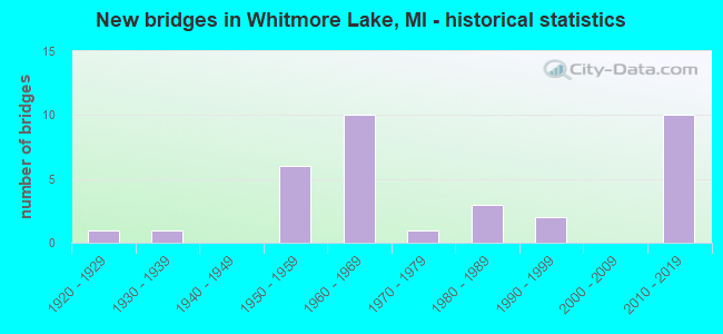
- New bridges - historical statistics
- 11920-1929
- 11930-1939
- 61950-1959
- 101960-1969
- 11970-1979
- 31980-1989
- 21990-1999
- 102010-2019

- Reconstructed bridges - Historical Statistics
- 11940-1949
- 01950-1959
- 01960-1969
- 01970-1979
- 01980-1989
- 11990-1999
- 42000-2009


- Bridge Condition - Deck
- 4.5%Excellent
- 9.1%Very good
- 40.9%Good
- 36.4%Satisfactory
- 4.5%Fair
- 4.5%Poor

- Bridge Condition - Superstructure
- 4.5%Excellent
- 27.3%Very good
- 22.7%Good
- 22.7%Satisfactory
- 9.1%Fair
- 9.1%Poor
- 4.5%Serious

- Bridge Condition - Substructure
- 18.2%Very good
- 50.0%Good
- 27.3%Satisfactory
- 4.5%Fair

- Bridge Condition - Channel
- 18.8%Very good
- 37.5%Good
- 31.3%Satisfactory
- 12.5%Fair

- Bridge Condition - Culverts
- 25.0%Very good
- 25.0%Good
- 25.0%Satisfactory
- 25.0%Fair
Find on map >> Show street view
Structure Number: 573, Location: 2.2 MI N OF M-36 (Lat: 42.471083, Lng: -83.755736), Route carried "on" structure: US 23, Year Built: 1960, Year Reconstructed: 2011, Status: Open, Structure Length: 2.77m (9.09ft), Average Daily Traffic: 34,500 (year 2008), Truck Traffic: 16%, Average Future Daily Traffic: 45,700 (year 2028), Design Load: Greater than HL93, Features Intersected: HURON RIVER
Minimum Vertical Clearance: 30.48m (100.00ft), Kilometerpoint: 5.036, Lanes on structure: 3, Base Highway Network: Yes (Inventory Route: 93, Subroute: 10), Owner: State Highway Agency, Approaching Roadway Width: 17.7m (58.1ft), Skew: 12 degrees, Material/Design: Steel, Design/Construction: Stringer/Multi-beam, Number Of Spans In Main Unit: 2, Length of Maximum Span: 13.1m (43.0ft), Curb-To-Curb Width: 17.8m (58.4ft), Out-to-Out Width: 18.7m (61.4ft)
Condition: Deck: Good, Superstructure: Good, Substructure: Good, Channel: Good, Operating Rating: 60.3 metric tons, Method Used To Determine Operating Rating: Load and Resistance Factor Rating (LRFR) rating reported by rating factor(RF) method using HL-93 loadings, Inventory Rating: 46.7 metric tons, Method Used To Determine Inventory Rating: Load and Resistance Factor Rating (LRFR) rating reported by rating factor(RF) method using HL-93 loadings, Structural Evaluation: Better than present minimum criteria, Deck Geometry: Superior to present desirable criteria, Waterway Adequacy: Equal to present desirable criteria, Approach Roadway Alignment: Equal to present desirable criteria, Designated Inspection Frequency: Every 24 months, Inspection Date: July 2021, Deck Structure Type: Concrete Cast-file-Place, Wearing Surface/Protective System: Wearing Surface: Monolithic Concrete, Deck Protection: Epoxy Coated Reinforcing
Find on map >> Show street view
Structure Number: 5731, Location: 2.2 MI N OF M-36 (Lat: 42.471250, Lng: -83.756075), Route carried "on" structure: US 23, Year Built: 1960, Year Reconstructed: 2011, Status: Open, Structure Length: 2.77m (9.09ft), Average Daily Traffic: 33,800 (year 2008), Truck Traffic: 16%, Average Future Daily Traffic: 44,700 (year 2028), Design Load: Greater than HL93, Features Intersected: HURON RIVER
Minimum Vertical Clearance: 30.48m (100.00ft), Kilometerpoint: 5.058, Lanes on structure: 3, Base Highway Network: Yes (Inventory Route: 93, Subroute: 2), Owner: State Highway Agency, Approaching Roadway Width: 17.7m (58.1ft), Skew: 12 degrees, Material/Design: Steel, Design/Construction: Stringer/Multi-beam, Number Of Spans In Main Unit: 2, Length of Maximum Span: 13.1m (43.0ft), Curb-To-Curb Width: 17.8m (58.4ft), Out-to-Out Width: 18.7m (61.4ft)
Condition: Deck: Good, Superstructure: Good, Substructure: Good, Channel: Good, Operating Rating: 60.3 metric tons, Method Used To Determine Operating Rating: Load and Resistance Factor Rating (LRFR) rating reported by rating factor(RF) method using HL-93 loadings, Inventory Rating: 46.7 metric tons, Method Used To Determine Inventory Rating: Load and Resistance Factor Rating (LRFR) rating reported by rating factor(RF) method using HL-93 loadings, Structural Evaluation: Better than present minimum criteria, Deck Geometry: Superior to present desirable criteria, Waterway Adequacy: Equal to present desirable criteria, Approach Roadway Alignment: Equal to present desirable criteria, Designated Inspection Frequency: Every 24 months, Inspection Date: July 2021, Deck Structure Type: Concrete Cast-file-Place, Wearing Surface/Protective System: Wearing Surface: Monolithic Concrete, Deck Protection: Epoxy Coated Reinforcing
Find on map >> Show street view
Structure Number: 5733, Location: 1.8 MI N OF M-36 (Lat: 42.467003, Lng: -83.755975), Route carried "on" structure: US 23, Year Built: 1960, Status: Open, Structure Length: 3.31m (10.86ft), Average Daily Traffic: 33,500 (year 2008), Truck Traffic: 10%, Average Future Daily Traffic: 40,000 (year 2028), Design Load: HS 20, Features Intersected: SILVER LAKE RD
Minimum Vertical Clearance: 30.48m (100.00ft), Kilometerpoint: 4.582, Lanes on structure: 2, Lanes under structure: 2, Base Highway Network: Yes (Inventory Route: 93, Subroute: 10), Owner: State Highway Agency, Approaching Roadway Width: 13.4m (44.0ft), Skew: 10 degrees, Material/Design: Steel, Design/Construction: Stringer/Multi-beam, Number Of Spans In Main Unit: 3, Length of Maximum Span: 12.4m (40.7ft), Curb-To-Curb Width: 13.4m (44.0ft), Out-to-Out Width: 14.4m (47.2ft)
Condition: Deck: Satisfactory, Superstructure: Satisfactory, Substructure: Satisfactory, Operating Rating: 87.1 metric tons, Method Used To Determine Operating Rating: Load Factor (LF), Inventory Rating: 52.3 metric tons, Method Used To Determine Inventory Rating: Load Factor (LF), Structural Evaluation: Equal to present minimum criteria, Deck Geometry: Superior to present desirable criteria, Underclear: Somewhat better than minimum adequacy, Approach Roadway Alignment: Equal to present desirable criteria, Designated Inspection Frequency: Every 24 months, Inspection Date: July 2021, Deck Structure Type: Concrete Cast-file-Place, Wearing Surface/Protective System: Wearing Surface: Latex Concrete
Find on map >> Show street view
Structure Number: 5734, Location: 1.8 MI N OF M-36 (Lat: 42.466964, Lng: -83.756325), Route carried "on" structure: US 23, Year Built: 1960, Status: Open, Structure Length: 3.31m (10.86ft), Average Daily Traffic: 33,500 (year 2008), Truck Traffic: 10%, Average Future Daily Traffic: 40,000 (year 2028), Design Load: HS 20, Features Intersected: SILVER LAKE RD
Minimum Vertical Clearance: 30.48m (100.00ft), Kilometerpoint: 4.582, Lanes on structure: 2, Lanes under structure: 2, Base Highway Network: Yes (Inventory Route: 93, Subroute: 2), Owner: State Highway Agency, Approaching Roadway Width: 13.4m (44.0ft), Skew: 10 degrees, Material/Design: Steel, Design/Construction: Stringer/Multi-beam, Number Of Spans In Main Unit: 3, Length of Maximum Span: 14.0m (45.9ft), Curb-To-Curb Width: 13.4m (44.0ft), Out-to-Out Width: 14.4m (47.2ft)
Condition: Deck: Satisfactory, Superstructure: Satisfactory, Substructure: Satisfactory, Operating Rating: 87.2 metric tons, Method Used To Determine Operating Rating: Load Factor (LF), Inventory Rating: 52.3 metric tons, Method Used To Determine Inventory Rating: Load Factor (LF), Structural Evaluation: Equal to present minimum criteria, Deck Geometry: Superior to present desirable criteria, Underclear: Somewhat better than minimum adequacy, Approach Roadway Alignment: Equal to present desirable criteria, Designated Inspection Frequency: Every 24 months, Inspection Date: July 2021, Deck Structure Type: Concrete Cast-file-Place, Wearing Surface/Protective System: Wearing Surface: Latex Concrete, Deck Protection: Epoxy Coated Reinforcing
Find on map >> Show street view
Structure Number: 5756, Location: 1.2 MI E OF LAKELAND (Lat: 42.460178, Lng: -83.824781), Route carried "on" structure: State highway 36, Year Built: 1986, Status: Open, Structure Length: 4.26m (13.98ft), Average Daily Traffic: 15,725 (year 2007), Truck Traffic: 2%, Average Future Daily Traffic: 20,694 (year 2018), Design Load: HS 20, Features Intersected: HURON RIVER
Minimum Vertical Clearance: 30.48m (100.00ft), Kilometerpoint: 20.937, Lanes on structure: 2, Base Highway Network: Yes (Inventory Route: 93, Subroute: 8), Owner: State Highway Agency, Approaching Roadway Width: 9.1m (29.9ft), Skew: 1 degrees, Material/Design: Steel, Design/Construction: Stringer/Multi-beam, Number Of Spans In Main Unit: 1, Length of Maximum Span: 42.6m (139.8ft), Curb-To-Curb Width: 14.6m (47.9ft), Out-to-Out Width: 15.6m (51.2ft)
Condition: Deck: Good, Superstructure: Satisfactory, Substructure: Good, Channel: Good, Operating Rating: 49.9 metric tons, Method Used To Determine Operating Rating: Load and Resistance Factor Rating (LRFR) rating reported by rating factor(RF) method using HL-93 loadings, Inventory Rating: 38.6 metric tons, Method Used To Determine Inventory Rating: Load and Resistance Factor Rating (LRFR) rating reported by rating factor(RF) method using HL-93 loadings, Structural Evaluation: Equal to present minimum criteria, Deck Geometry: Superior to present desirable criteria, Waterway Adequacy: Better than present minimum criteria, Approach Roadway Alignment: Equal to present minimum criteria, Designated Inspection Frequency: Every 24 months, Inspection Date: September 2021, Bridge Improvement Cost: $296,000, Deck Structure Type: Concrete Cast-file-Place, Wearing Surface/Protective System: Wearing Surface: Monolithic Concrete, Deck Protection: Epoxy Coated Reinforcing
Find on map >> Show street view
Structure Number: 5808, Location: SEC 27-34 GREEN OAK TWP (Lat: 42.444186, Lng: -83.709111), Route carried "on" structure: County highway 4793, Year Built: 1983, Status: Open, Structure Length: 0.62m (2.03ft), Average Daily Traffic: 6,440 (year 2020), Average Future Daily Traffic: 7,728 (year 2040), Design Load: HS 20+Mod, Features Intersected: LIME KILN LAKE INLET, Facility Carried by Structure: NINE MILE ROAD
Minimum Vertical Clearance: 30.48m (100.00ft), Kilometerpoint: 3.537, Lanes on structure: 2, Owner: County Highway Agency, Approaching Roadway Width: 8.5m (27.9ft), Material/Design: Steel, Design/Construction: Culvert, Number Of Spans In Main Unit: 2, Length of Maximum Span: 2.7m (8.9ft), Curb-To-Curb Width: 12.5m (41.0ft), Out-to-Out Width: 13.1m (43.0ft)
Condition: Channel: Fair, Culverts: Fair, Operating Rating: 54.1 metric tons, Method Used To Determine Operating Rating: Load Factor (LF) rating reported by rating factor (RF) method using MS18 loading, Inventory Rating: 32.4 metric tons, Method Used To Determine Inventory Rating: Load Factor (LF) rating reported by rating factor (RF) method using MS18 loading, Structural Evaluation: Somewhat better than minimum adequacy, Deck Geometry: Somewhat better than minimum adequacy, Waterway Adequacy: Better than present minimum criteria, Approach Roadway Alignment: Equal to present desirable criteria, Designated Inspection Frequency: Every 24 months, Inspection Date: July 2021
Find on map >> Show street view
Structure Number: 581, Location: SEC 22 GREEN OAK TWP (Lat: 42.466064, Lng: -83.706981), Route carried "on" structure: County highway 4710, Year Built: 1987, Status: Open, Structure Length: 1.34m (4.40ft), Average Daily Traffic: 3,830 (year 2013), Average Future Daily Traffic: 4,130 (year 2043), Design Load: HS 20+Mod, Features Intersected: DAVIS CREEK, Facility Carried by Structure: DOANE ROAD
Minimum Vertical Clearance: 30.48m (100.00ft), Kilometerpoint: 0.818, Lanes on structure: 2, Owner: County Highway Agency, Approaching Roadway Width: 7.9m (25.9ft), Skew: 2 degrees, Material/Design: Prestressed concrete, Design/Construction: Box Beam or Girders - Multiple, Number Of Spans In Main Unit: 1, Length of Maximum Span: 13.1m (43.0ft), Curb-To-Curb Width: 12.2m (40.0ft), Out-to-Out Width: 12.3m (40.4ft)
Condition: Deck: Satisfactory, Superstructure: Good, Substructure: Good, Channel: Satisfactory, Operating Rating: 70.3 metric tons, Method Used To Determine Operating Rating: Load Factor (LF) rating reported by rating factor (RF) method using MS18 loading, Inventory Rating: 42.1 metric tons, Method Used To Determine Inventory Rating: Load Factor (LF) rating reported by rating factor (RF) method using MS18 loading, Structural Evaluation: Better than present minimum criteria, Deck Geometry: Equal to present minimum criteria, Waterway Adequacy: Equal to present desirable criteria, Approach Roadway Alignment: Equal to present minimum criteria, Designated Inspection Frequency: Every 24 months, Inspection Date: August 2021, Deck Structure Type: Concrete Precast Panels, Wearing Surface/Protective System: Wearing Surface: Bituminous
Find on map >> Show street view
Structure Number: 5811, Location: SEC 21 GREEN OAK TWP (Lat: 42.468867, Lng: -83.744011), Route carried "on" structure: County highway 4710, Year Built: 1958, Status: Open, Structure Length: 1.22m (4.00ft), Average Daily Traffic: 7,030 (year 2013), Average Future Daily Traffic: 7,751 (year 2030), Design Load: HS 20+Mod, Features Intersected: DAVIS CREEK, Facility Carried by Structure: SILVER LAKE ROAD
Minimum Vertical Clearance: 30.48m (100.00ft), Kilometerpoint: 1.139, Lanes on structure: 2, Owner: County Highway Agency, Approaching Roadway Width: 7.9m (25.9ft), Skew: 1 degrees, Material/Design: Concrete, Design/Construction: Tee Beam, Number Of Spans In Main Unit: 1, Length of Maximum Span: 11.5m (37.7ft), Curb-To-Curb Width: 9.1m (29.9ft), Out-to-Out Width: 10.8m (35.4ft)
Condition: Deck: Good, Superstructure: Good, Substructure: Good, Channel: Satisfactory, Operating Rating: 54.6 metric tons, Method Used To Determine Operating Rating: Field evaluation and documented engineering judgment, Inventory Rating: 32.7 metric tons, Method Used To Determine Inventory Rating: Field evaluation and documented engineering judgment, Structural Evaluation: Better than present minimum criteria, Deck Geometry: High priority of corrective action, Waterway Adequacy: Equal to present desirable criteria, Approach Roadway Alignment: Equal to present desirable criteria, Designated Inspection Frequency: Every 24 months, Inspection Date: August 2021, Deck Structure Type: Concrete Cast-file-Place, Wearing Surface/Protective System: Wearing Surface: Bituminous
Find on map >> Show street view
Structure Number: 5838, Location: SEC 24 HAMBURG TWP (Lat: 42.465133, Lng: -83.800092), Route carried "on" structure: County highway 4771, Year Built: 1963, Status: Open, Structure Length: 4.11m (13.48ft), Average Daily Traffic: 4,959 (year 2013), Truck Traffic: 2%, Average Future Daily Traffic: 8,867 (year 2028), Design Load: HS 20, Features Intersected: HURON RIVER, Facility Carried by Structure: HAMBURG ROAD
Minimum Vertical Clearance: 30.48m (100.00ft), Kilometerpoint: 2.968, Lanes on structure: 2, Owner: County Highway Agency, Approaching Roadway Width: 9.1m (29.9ft), Material/Design: Steel, Design/Construction: Stringer/Multi-beam, Number Of Spans In Main Unit: 3, Length of Maximum Span: 13.4m (44.0ft), Curb or Sidewalk Widths: Left: 0.5m (1.6ft), Right: 0.5m (1.6ft), Curb-To-Curb Width: 9.1m (29.9ft), Out-to-Out Width: 11.4m (37.4ft)
Condition: Deck: Good, Superstructure: Good, Substructure: Good, Channel: Good, Operating Rating: 67.4 metric tons, Method Used To Determine Operating Rating: Load Factor (LF) rating reported by rating factor (RF) method using MS18 loading, Inventory Rating: 40.2 metric tons, Method Used To Determine Inventory Rating: Load Factor (LF) rating reported by rating factor (RF) method using MS18 loading, Structural Evaluation: Better than present minimum criteria, Deck Geometry: Meets minimum limits, Waterway Adequacy: Equal to present desirable criteria, Approach Roadway Alignment: Equal to present desirable criteria, Designated Inspection Frequency: Every 24 months, Inspection Date: November 2020, Deck Structure Type: Concrete Cast-file-Place, Wearing Surface/Protective System: Wearing Surface: Latex Concrete
Find on map >> Show street view
Structure Number: 5841, Location: SEC 32 GREEN OAK TWP (Lat: 42.441247, Lng: -83.757097), Route carried "on" structure: County highway , Year Built: 1960, Status: Open, Structure Length: 4.20m (13.78ft), Average Daily Traffic: 2,433 (year 2020), Average Future Daily Traffic: 2,920 (year 2040), Design Load: HS 20+Mod, Features Intersected: CN-GTC-GTW RR (ABN), Facility Carried by Structure: WHITMORE LAKE ROAD
Minimum Vertical Clearance: 30.48m (100.00ft), Kilometerpoint: 1.791, Lanes on structure: 2, Owner: County Highway Agency, Approaching Roadway Width: 9.1m (29.9ft), Material/Design: Prestressed concrete, Design/Construction: Box Beam or Girders - Multiple, Number Of Spans In Main Unit: 3, Length of Maximum Span: 13.7m (44.9ft), Curb or Sidewalk Widths: Left: 0.8m (2.6ft), Right: 0.7m (2.3ft), Curb-To-Curb Width: 7.9m (25.9ft), Out-to-Out Width: 10.1m (33.1ft)
Condition: Deck: Satisfactory, Superstructure: Fair, Substructure: Satisfactory, Operating Rating: 63.8 metric tons, Method Used To Determine Operating Rating: Load Factor (LF) rating reported by rating factor (RF) method using MS18 loading, Inventory Rating: 36.6 metric tons, Method Used To Determine Inventory Rating: Load Factor (LF) rating reported by rating factor (RF) method using MS18 loading, Structural Evaluation: Somewhat better than minimum adequacy, Deck Geometry: High priority of corrective action, Approach Roadway Alignment: Equal to present desirable criteria, Designated Inspection Frequency: Every 24 months, Inspection Date: July 2021, Deck Structure Type: Concrete Cast-file-Place, Wearing Surface/Protective System: Wearing Surface: Bituminous
Find on map >> Show street view
Structure Number: 586, Location: SEC 28 GREEN OAK TWP (Lat: 42.456256, Lng: -83.740253), Route carried "on" structure: County highway , Year Built: 1996, Status: Open, Structure Length: 1.67m (5.48ft), Average Daily Traffic: 158 (year 2013), Average Future Daily Traffic: 500 (year 2015), Design Load: HS 20, Features Intersected: DAVIS CREEK, Facility Carried by Structure: FAIRLANE ROAD
Minimum Vertical Clearance: 30.48m (100.00ft), Kilometerpoint: 0.996, Lanes on structure: 2, Owner: County Highway Agency, Approaching Roadway Width: 9.1m (29.9ft), Material/Design: Prestressed concrete, Design/Construction: Box Beam or Girders - Multiple, Number Of Spans In Main Unit: 1, Length of Maximum Span: 15.5m (50.9ft), Curb-To-Curb Width: 9.1m (29.9ft), Out-to-Out Width: 10.0m (32.8ft)
Condition: Deck: Excellent, Superstructure: Very good, Substructure: Very good, Channel: Good, Operating Rating: 60.6 metric tons, Method Used To Determine Operating Rating: Load Factor (LF) rating reported by rating factor (RF) method using MS18 loading, Inventory Rating: 36.3 metric tons, Method Used To Determine Inventory Rating: Load Factor (LF) rating reported by rating factor (RF) method using MS18 loading, Structural Evaluation: Equal to present desirable criteria, Deck Geometry: Equal to present minimum criteria, Waterway Adequacy: Better than present minimum criteria, Approach Roadway Alignment: Equal to present desirable criteria, Designated Inspection Frequency: Every 24 months, Inspection Date: November 2020, Deck Structure Type: Concrete Cast-file-Place, Wearing Surface/Protective System: Wearing Surface: Monolithic Concrete, Deck Protection: Epoxy Coated Reinforcing
Find on map >> Show street view
Structure Number: 5861, Location: SEC 16 GREEN OAK TWP (Lat: 42.483089, Lng: -83.741831), Route carried "on" structure: County highway , Year Built: 1930, Year Reconstructed: 1953, Status: Closed, Structure Length: 1.70m (5.58ft), Average Daily Traffic: 300 (year 2018), Average Future Daily Traffic: 408 (year 2038), Design Load: H 15, Features Intersected: HURON RIVER, Facility Carried by Structure: MCCABE ROAD
Minimum Vertical Clearance: 30.48m (100.00ft), Kilometerpoint: 0.663, Lanes on structure: 2, Owner: County Highway Agency, Approaching Roadway Width: 6.1m (20.0ft), Material/Design: Steel, Design/Construction: Girder and Floorbeam System, Number Of Spans In Main Unit: 1, Length of Maximum Span: 16.4m (53.8ft), Curb-To-Curb Width: 5.8m (19.0ft), Out-to-Out Width: 6.7m (22.0ft)
Condition: Deck: Satisfactory, Superstructure: Serious, Substructure: Satisfactory, Channel: Fair, Operating Rating: 50.9 metric tons, Method Used To Determine Operating Rating: Load Factor (LF) rating reported by rating factor (RF) method using MS18 loading, Inventory Rating: 30.5 metric tons, Method Used To Determine Inventory Rating: Load Factor (LF) rating reported by rating factor (RF) method using MS18 loading, Structural Evaluation: High priority of corrective action, Waterway Adequacy: Equal to present desirable criteria, Approach Roadway Alignment: Somewhat better than minimum adequacy, Bridge Posting: Required (Relationship of Operating Rating to Maximum Legal Load: > 39.9% below), Designated Inspection Frequency: Every 24 months, Critical Feature Inspection Frequency: Every 24 months, Inspection Date: October 2021, Critical Feature Inspection Date: October 2021, Deck Structure Type: Concrete Cast-file-Place, Wearing Surface/Protective System: Wearing Surface: Monolithic Concrete
Find on map >> Show street view
Structure Number: 5862, Location: SEC 17-18 GREEN OAK TWP (Lat: 42.478631, Lng: -83.767228), Route carried "on" structure: County highway , Year Built: 1973, Year Reconstructed: 2001, Status: Open, Structure Length: 2.25m (7.38ft), Average Daily Traffic: 5,910 (year 2020), Truck Traffic: 2%, Average Future Daily Traffic: 6,383 (year 2030), Design Load: HS 20, Features Intersected: HURON RIVER, Facility Carried by Structure: RICKETT ROAD
Minimum Vertical Clearance: 30.48m (100.00ft), Kilometerpoint: 1.632, Lanes on structure: 2, Owner: County Highway Agency, Approaching Roadway Width: 7.9m (25.9ft), Material/Design: Prestressed concrete, Design/Construction: Tee Beam, Number Of Spans In Main Unit: 1, Length of Maximum Span: 21.9m (71.9ft), Curb-To-Curb Width: 9.8m (32.2ft), Out-to-Out Width: 11.5m (37.7ft)
Condition: Deck: Fair, Superstructure: Poor, Substructure: Very good, Channel: Very good, Operating Rating: 59.3 metric tons, Method Used To Determine Operating Rating: Load Factor (LF) rating reported by rating factor (RF) method using MS18 loading, Inventory Rating: 28.8 metric tons, Method Used To Determine Inventory Rating: Load Factor (LF) rating reported by rating factor (RF) method using MS18 loading, Structural Evaluation: Meets minimum limits, Deck Geometry: Meets minimum limits, Waterway Adequacy: Equal to present desirable criteria, Approach Roadway Alignment: Equal to present desirable criteria, Designated Inspection Frequency: Every 12 months, Inspection Date: June 2021, Deck Structure Type: Other, Wearing Surface/Protective System: Wearing Surface: Bituminous, Membrane: Preformed Fabric
Find on map >> Show street view
Structure Number: 5863, Location: SEC 20 GREEN OAK TWP (Lat: 42.470900, Lng: -83.755408), Route carried "on" structure: ServiceCounty highway , Year Built: 1961, Status: Posted for load, Structure Length: 2.76m (9.06ft), Average Daily Traffic: 1,320 (year 2013), Average Future Daily Traffic: 2,714 (year 2019), Design Load: HS 20+Mod, Features Intersected: HURON RIVER, Facility Carried by Structure: FIELD CREST ROAD
Minimum Vertical Clearance: 30.48m (100.00ft), Kilometerpoint: 3.257, Lanes on structure: 2, Owner: County Highway Agency, Approaching Roadway Width: 7.9m (25.9ft), Skew: 3 degrees, Material/Design: Prestressed concrete, Design/Construction: Box Beam or Girders - Multiple, Number Of Spans In Main Unit: 2, Length of Maximum Span: 13.9m (45.6ft), Curb or Sidewalk Widths: Left: 0.6m (2.0ft), Right: 0.6m (2.0ft), Curb-To-Curb Width: 7.3m (24.0ft), Out-to-Out Width: 9.2m (30.2ft)
Condition: Deck: Satisfactory, Superstructure: Satisfactory, Substructure: Good, Channel: Good, Operating Rating: 37.3 metric tons, Method Used To Determine Operating Rating: Load Factor (LF) rating reported by rating factor (RF) method using MS18 loading, Inventory Rating: 20.4 metric tons, Method Used To Determine Inventory Rating: Load Factor (LF) rating reported by rating factor (RF) method using MS18 loading, Structural Evaluation: Somewhat better than minimum adequacy, Deck Geometry: Meets minimum limits, Waterway Adequacy: Better than present minimum criteria, Approach Roadway Alignment: Equal to present minimum criteria, Bridge Posting: Required (Relationship of Operating Rating to Maximum Legal Load: 20.0 - 29.9% below), Designated Inspection Frequency: Every 24 months, Inspection Date: August 2021, Deck Structure Type: Concrete Cast-file-Place, Wearing Surface/Protective System: Wearing Surface: Monolithic Concrete
Find on map >> Show street view
Structure Number: 10876, Location: 0.5 MI S OF LIVINGSTON CO (Lat: 42.424967, Lng: -83.768283), Route carried "on" structure: US 23, Year Built: 2017, Status: Open, Structure Length: 3.35m (10.99ft), Average Daily Traffic: 33,375 (year 2017), Truck Traffic: 8%, Average Future Daily Traffic: 35,775 (year 2037), Design Load: Greater than HL93, Features Intersected: MDOT RR CORRIDOR
Minimum Vertical Clearance: 30.48m (100.00ft), Kilometerpoint: 12.450, Lanes on structure: 3, Base Highway Network: Yes (Inventory Route: 143, Subroute: 3), Owner: State Highway Agency, Approaching Roadway Width: 17.3m (56.8ft), Skew: 4 degrees, Material/Design: Steel, Design/Construction: Stringer/Multi-beam, Number Of Spans In Main Unit: 1, Length of Maximum Span: 31.9m (104.7ft), Curb-To-Curb Width: 17.4m (57.1ft), Out-to-Out Width: 18.4m (60.4ft)
Condition: Deck: Very good, Superstructure: Very good, Substructure: Good, Operating Rating: 68.7 metric tons, Method Used To Determine Operating Rating: Load and Resistance Factor Rating (LRFR) rating reported by rating factor(RF) method using HL-93 loadings, Inventory Rating: 53.1 metric tons, Method Used To Determine Inventory Rating: Load and Resistance Factor Rating (LRFR) rating reported by rating factor(RF) method using HL-93 loadings, Structural Evaluation: Better than present minimum criteria, Deck Geometry: Superior to present desirable criteria, Approach Roadway Alignment: Better than present minimum criteria, Designated Inspection Frequency: Every 24 months, Inspection Date: October 2021, Deck Structure Type: Concrete Cast-file-Place, Wearing Surface/Protective System: Wearing Surface: Monolithic Concrete, Deck Protection: Epoxy Coated Reinforcing
Find on map >> Show street view
Structure Number: 10877, Location: 0.5 MI S OF LIVINGSTON CO (Lat: 42.425200, Lng: -83.768519), Route carried "on" structure: US 23, Year Built: 2017, Status: Open, Structure Length: 3.29m (10.79ft), Average Daily Traffic: 33,375 (year 2017), Truck Traffic: 8%, Average Future Daily Traffic: 35,775 (year 2037), Design Load: Greater than HL93, Features Intersected: MDOT RR CORRIDOR
Minimum Vertical Clearance: 30.48m (100.00ft), Kilometerpoint: 12.439, Lanes on structure: 4, Base Highway Network: Yes (Inventory Route: 143, Subroute: 5), Owner: State Highway Agency, Approaching Roadway Width: 16.4m (53.8ft), Skew: 4 degrees, Material/Design: Steel, Design/Construction: Stringer/Multi-beam, Number Of Spans In Main Unit: 1, Length of Maximum Span: 31.3m (102.7ft), Curb-To-Curb Width: 21.0m (68.9ft), Out-to-Out Width: 22.0m (72.2ft)
Condition: Deck: Very good, Superstructure: Very good, Substructure: Very good, Operating Rating: 76.1 metric tons, Method Used To Determine Operating Rating: Load and Resistance Factor Rating (LRFR) rating reported by rating factor(RF) method using HL-93 loadings, Inventory Rating: 58.6 metric tons, Method Used To Determine Inventory Rating: Load and Resistance Factor Rating (LRFR) rating reported by rating factor(RF) method using HL-93 loadings, Structural Evaluation: Equal to present desirable criteria, Deck Geometry: Superior to present desirable criteria, Approach Roadway Alignment: Better than present minimum criteria, Designated Inspection Frequency: Every 24 months, Inspection Date: October 2021, Deck Structure Type: Concrete Cast-file-Place, Wearing Surface/Protective System: Wearing Surface: Monolithic Concrete, Deck Protection: Epoxy Coated Reinforcing
Find on map >> Show street view
Structure Number: 10881, Location: 3.7 MI S OF LIVINGSTON CO (Lat: 42.379397, Lng: -83.756800), Route carried "on" structure: County highway 8184, Year Built: 2017, Status: Open, Structure Length: 5.49m (18.01ft), Average Daily Traffic: 9,666 (year 1993), Truck Traffic: 3%, Average Future Daily Traffic: 11,116 (year 2013), Design Load: Greater than HL93, Features Intersected: US-23, Facility Carried by Structure: N TERRITORIAL RD
Minimum Vertical Clearance: 30.48m (100.00ft), Kilometerpoint: 27.649, Lanes on structure: 2, Lanes under structure: 4, Owner: State Highway Agency, Approaching Roadway Width: 10.3m (33.8ft), Skew: 1 degrees, Material/Design: Prestressed concrete, Design/Construction: Stringer/Multi-beam, Number Of Spans In Main Unit: 2, Length of Maximum Span: 26.7m (87.6ft), Curb-To-Curb Width: 13.4m (44.0ft), Out-to-Out Width: 14.1m (46.3ft)
Condition: Deck: Good, Superstructure: Excellent, Substructure: Good, Operating Rating: 62.2 metric tons, Method Used To Determine Operating Rating: Load and Resistance Factor Rating (LRFR) rating reported by rating factor(RF) method using HL-93 loadings, Inventory Rating: 38.2 metric tons, Method Used To Determine Inventory Rating: Load and Resistance Factor Rating (LRFR) rating reported by rating factor(RF) method using HL-93 loadings, Structural Evaluation: Better than present minimum criteria, Deck Geometry: Equal to present minimum criteria, Underclear: Superior to present desirable criteria, Approach Roadway Alignment: Equal to present desirable criteria, Designated Inspection Frequency: Every 24 months, Inspection Date: October 2021, Deck Structure Type: Concrete Cast-file-Place, Wearing Surface/Protective System: Wearing Surface: Monolithic Concrete, Deck Protection: Epoxy Coated Reinforcing
Find on map >> Show street view
Structure Number: 10882, Location: 2.7 MI S OF LIVINGSTON CO (Lat: 42.394467, Lng: -83.763467), Route carried "on" structure: County highway , Year Built: 2017, Status: Open, Structure Length: 6.09m (19.98ft), Average Daily Traffic: 5,625 (year 2017), Truck Traffic: 3%, Average Future Daily Traffic: 5,970 (year 2037), Design Load: Greater than HL93, Features Intersected: US-23, Facility Carried by Structure: 6 MI RD
Minimum Vertical Clearance: 30.48m (100.00ft), Kilometerpoint: 0.389, Lanes on structure: 2, Lanes under structure: 5, Owner: State Highway Agency, Approaching Roadway Width: 12.2m (40.0ft), Skew: 2 degrees, Material/Design: Prestressed concrete, Design/Construction: Stringer/Multi-beam, Number Of Spans In Main Unit: 2, Length of Maximum Span: 30.0m (98.4ft), Curb or Sidewalk Widths: Left: 1.6m (5.2ft), Right: 1.6m (5.2ft), Curb-To-Curb Width: 10.4m (34.1ft), Out-to-Out Width: 14.3m (46.9ft)
Condition: Deck: Good, Superstructure: Very good, Substructure: Good, Operating Rating: 67.1 metric tons, Method Used To Determine Operating Rating: Load and Resistance Factor Rating (LRFR) rating reported by rating factor(RF) method using HL-93 loadings, Inventory Rating: 42.8 metric tons, Method Used To Determine Inventory Rating: Load and Resistance Factor Rating (LRFR) rating reported by rating factor(RF) method using HL-93 loadings, Structural Evaluation: Better than present minimum criteria, Deck Geometry: Meets minimum limits, Underclear: Better than present minimum criteria, Approach Roadway Alignment: Equal to present desirable criteria, Designated Inspection Frequency: Every 24 months, Inspection Date: October 2021, Deck Structure Type: Concrete Cast-file-Place, Wearing Surface/Protective System: Wearing Surface: Monolithic Concrete, Deck Protection: Epoxy Coated Reinforcing
Find on map >> Show street view
Structure Number: 10883, Location: 0.7 MI S OF CO LINE (Lat: 42.422531, Lng: -83.768142), Route carried "on" structure: US 23, Year Built: 1958, Year Reconstructed: 2006, Status: Open, Structure Length: 4.30m (14.11ft), Average Daily Traffic: 33,375 (year 2017), Truck Traffic: 8%, Average Future Daily Traffic: 35,775 (year 2037), Design Load: HS 20, Features Intersected: BARKER RD
Minimum Vertical Clearance: 30.48m (100.00ft), Kilometerpoint: 12.178, Lanes on structure: 3, Lanes under structure: 2, Base Highway Network: Yes (Inventory Route: 143, Subroute: 3), Owner: State Highway Agency, Approaching Roadway Width: 16.7m (54.8ft), Material/Design: Concrete continuous, Design/Construction: Tee Beam, Number Of Spans In Main Unit: 3, Length of Maximum Span: 16.7m (54.8ft), Curb-To-Curb Width: 17.3m (56.8ft), Out-to-Out Width: 18.3m (60.0ft)
Condition: Deck: Satisfactory, Superstructure: Satisfactory, Substructure: Good, Operating Rating: 43.4 metric tons, Method Used To Determine Operating Rating: Load and Resistance Factor Rating (LRFR) rating reported by rating factor(RF) method using HL-93 loadings, Inventory Rating: 21.4 metric tons, Method Used To Determine Inventory Rating: Load and Resistance Factor Rating (LRFR) rating reported by rating factor(RF) method using HL-93 loadings, Structural Evaluation: Somewhat better than minimum adequacy, Deck Geometry: Superior to present desirable criteria, Underclear: Equal to present minimum criteria, Approach Roadway Alignment: Equal to present desirable criteria, Designated Inspection Frequency: Every 24 months, Inspection Date: October 2021, Deck Structure Type: Concrete Cast-file-Place, Wearing Surface/Protective System: Wearing Surface: Latex Concrete, Deck Protection: Epoxy Coated Reinforcing
Find on map >> Show street view
Structure Number: 10884, Location: 0.7 MI S OF CO LINE (Lat: 42.422528, Lng: -83.768417), Route carried "on" structure: US 23, Year Built: 1958, Year Reconstructed: 2006, Status: Open, Structure Length: 4.30m (14.11ft), Average Daily Traffic: 33,375 (year 2017), Truck Traffic: 8%, Average Future Daily Traffic: 35,575 (year 2037), Design Load: HS 20, Features Intersected: BARKER RD
Minimum Vertical Clearance: 30.48m (100.00ft), Kilometerpoint: 12.141, Lanes on structure: 3, Lanes under structure: 2, Base Highway Network: Yes (Inventory Route: 143, Subroute: 5), Owner: State Highway Agency, Approaching Roadway Width: 16.7m (54.8ft), Material/Design: Concrete continuous, Design/Construction: Tee Beam, Number Of Spans In Main Unit: 3, Length of Maximum Span: 17.2m (56.4ft), Curb-To-Curb Width: 17.3m (56.8ft), Out-to-Out Width: 18.3m (60.0ft)
Condition: Deck: Satisfactory, Superstructure: Fair, Substructure: Satisfactory, Operating Rating: 43.4 metric tons, Method Used To Determine Operating Rating: Load and Resistance Factor Rating (LRFR) rating reported by rating factor(RF) method using HL-93 loadings, Inventory Rating: 21.4 metric tons, Method Used To Determine Inventory Rating: Load and Resistance Factor Rating (LRFR) rating reported by rating factor(RF) method using HL-93 loadings, Structural Evaluation: Somewhat better than minimum adequacy, Deck Geometry: Superior to present desirable criteria, Underclear: Better than present minimum criteria, Approach Roadway Alignment: Equal to present desirable criteria, Designated Inspection Frequency: Every 24 months, Inspection Date: October 2021, Deck Structure Type: Concrete Cast-file-Place, Wearing Surface/Protective System: Wearing Surface: Latex Concrete
Find on map >> Show street view
Structure Number: 10885, Location: AT LIVINGSTON CO LINE (Lat: 42.428728, Lng: -83.766897), Route carried "on" structure: County highway 8192, Year Built: 2017, Status: Open, Structure Length: 5.41m (17.75ft), Average Daily Traffic: 7,650 (year 2017), Truck Traffic: 4%, Average Future Daily Traffic: 8,125 (year 2037), Design Load: H 20, Features Intersected: US-23, Facility Carried by Structure: 8 MI RD
Minimum Vertical Clearance: 30.48m (100.00ft), Kilometerpoint: 1.951, Lanes on structure: 2, Lanes under structure: 4, Owner: State Highway Agency, Approaching Roadway Width: 11.5m (37.7ft), Skew: 1 degrees, Material/Design: Prestressed concrete, Design/Construction: Stringer/Multi-beam, Number Of Spans In Main Unit: 2, Length of Maximum Span: 26.3m (86.3ft), Curb or Sidewalk Widths: Left: 1.6m (5.2ft), Right: 1.6m (5.2ft), Curb-To-Curb Width: 10.4m (34.1ft), Out-to-Out Width: 14.3m (46.9ft)
Condition: Deck: Good, Superstructure: Very good, Substructure: Satisfactory, Operating Rating: 67.7 metric tons, Method Used To Determine Operating Rating: Load and Resistance Factor Rating (LRFR) rating reported by rating factor(RF) method using HL-93 loadings, Inventory Rating: 35.6 metric tons, Method Used To Determine Inventory Rating: Load and Resistance Factor Rating (LRFR) rating reported by rating factor(RF) method using HL-93 loadings, Structural Evaluation: Equal to present minimum criteria, Deck Geometry: Meets minimum limits, Underclear: Superior to present desirable criteria, Approach Roadway Alignment: Equal to present minimum criteria, Designated Inspection Frequency: Every 24 months, Inspection Date: October 2021, Deck Structure Type: Concrete Cast-file-Place, Wearing Surface/Protective System: Wearing Surface: Monolithic Concrete, Deck Protection: Epoxy Coated Reinforcing
Find on map >> Show street view
Structure Number: 10999, Location: NORTHFIELD TWP SEC 5 (Lat: 42.415436, Lng: -83.760961), Route carried "on" structure: County highway 8165, Year Built: 1920, Status: Open, Structure Length: 0.91m (2.99ft), Average Daily Traffic: 5,803 (year 2005), Truck Traffic: 12%, Average Future Daily Traffic: 10,480 (year 2025), Design Load: HS 20+Mod, Features Intersected: HORSESHOE LAKE OUTLET, Facility Carried by Structure: MAIN ST-WHITMORE
Minimum Vertical Clearance: 30.48m (100.00ft), Kilometerpoint: 2.417, Lanes on structure: 2, Owner: County Highway Agency, Approaching Roadway Width: 7.9m (25.9ft), Skew: 4 degrees, Material/Design: Concrete, Design/Construction: Tee Beam, Number Of Spans In Main Unit: 1, Length of Maximum Span: 7.9m (25.9ft), Curb or Sidewalk Widths: Left: 1.2m (3.9ft), Right: 0.0m, Curb-To-Curb Width: 9.1m (29.9ft), Out-to-Out Width: 11.0m (36.1ft)
Condition: Deck: Poor, Superstructure: Poor, Substructure: Fair, Channel: Satisfactory, Operating Rating: 36.0 metric tons, Method Used To Determine Operating Rating: Field evaluation and documented engineering judgment, Inventory Rating: 21.6 metric tons, Method Used To Determine Inventory Rating: Field evaluation and documented engineering judgment, Structural Evaluation: Meets minimum limits, Deck Geometry: High priority of corrective action, Waterway Adequacy: Somewhat better than minimum adequacy, Approach Roadway Alignment: Somewhat better than minimum adequacy, Length Of Structure Improvement: 1.37m (4.49ft), Designated Inspection Frequency: Every 24 months, Inspection Date: June 2021, Bridge Improvement Cost: $120,000, Roadway Improvement Cost: $25,000, Total Project Cost: $185,000, Deck Structure Type: Concrete Cast-file-Place, Wearing Surface/Protective System: Wearing Surface: Bituminous
Find on map >> Show street view
Structure Number: 11011, Location: NORTHFIELD TWP SEC 3 (Lat: 42.429669, Lng: -83.709517), Route carried "on" structure: County highway , Year Built: 1999, Status: Open, Structure Length: 1.60m (5.25ft), Average Daily Traffic: 468 (year 2005), Truck Traffic: 4%, Average Future Daily Traffic: 845 (year 2025), Design Load: HS 20, Features Intersected: TOBIN DRAIN, Facility Carried by Structure: 8 MILE ROAD
Minimum Vertical Clearance: 30.48m (100.00ft), Kilometerpoint: 1.233, Lanes on structure: 2, Owner: County Highway Agency, Approaching Roadway Width: 9.1m (29.9ft), Skew: 2 degrees, Material/Design: Prestressed concrete, Design/Construction: Box Beam or Girders - Multiple, Number Of Spans In Main Unit: 1, Length of Maximum Span: 16.0m (52.5ft), Curb-To-Curb Width: 9.1m (29.9ft), Out-to-Out Width: 9.5m (31.2ft)
Condition: Deck: Good, Superstructure: Very good, Substructure: Very good, Channel: Satisfactory, Operating Rating: 72.2 metric tons, Method Used To Determine Operating Rating: Load Factor (LF), Inventory Rating: 43.2 metric tons, Method Used To Determine Inventory Rating: Load Factor (LF), Structural Evaluation: Equal to present desirable criteria, Deck Geometry: Equal to present minimum criteria, Waterway Adequacy: Equal to present desirable criteria, Approach Roadway Alignment: Equal to present desirable criteria, Designated Inspection Frequency: Every 24 months, Inspection Date: June 2021, Deck Structure Type: Concrete Cast-file-Place, Wearing Surface/Protective System: Wearing Surface: Monolithic Concrete, Deck Protection: Epoxy Coated Reinforcing
Find on map >> Show street view
Structure Number: 13832, Location: N OF BARKER RD (Lat: 42.424136, Lng: -83.768431), Route carried "on" structure: US 23, Year Built: 1956, Status: Open, Structure Length: 0.81m (2.66ft), Average Daily Traffic: 66,750 (year 2017), Truck Traffic: 8%, Average Future Daily Traffic: 71,150 (year 2037), Features Intersected: HORSESHOE LAKE DRAIN
Minimum Vertical Clearance: 30.48m (100.00ft), Kilometerpoint: 12.352, Lanes on structure: 4, Base Highway Network: Yes (Inventory Route: 143, Subroute: 3), Owner: State Highway Agency, Approaching Roadway Width: 25.6m (84.0ft), Skew: 3 degrees, Material/Design: Concrete, Design/Construction: Culvert, Number Of Spans In Main Unit: 2, Length of Maximum Span: 3.5m (11.5ft), Curb-To-Curb Width: 34.7m (113.8ft), Out-to-Out Width: 96.4m (316.3ft)
Condition: Channel: Satisfactory, Culverts: Satisfactory, Operating Rating: 97.2 metric tons, Method Used To Determine Operating Rating: Load Factor (LF) rating reported by rating factor (RF) method using MS18 loading, Inventory Rating: 97.2 metric tons, Method Used To Determine Inventory Rating: Load Factor (LF) rating reported by rating factor (RF) method using MS18 loading, Structural Evaluation: Equal to present minimum criteria, Deck Geometry: Superior to present desirable criteria, Waterway Adequacy: Superior to present desirable criteria, Approach Roadway Alignment: Equal to present desirable criteria, Designated Inspection Frequency: Every 24 months, Inspection Date: October 2021, Wearing Surface/Protective System: Wearing Surface: Bituminous
Find on map >> Show street view
Structure Number: 13974, Location: 321 FT E OF NB US-23 (Lat: 42.379692, Lng: -83.755819), Route carried "on" structure: County highway 8184, Year Built: 2017, Status: Open, Structure Length: 0.73m (2.40ft), Average Daily Traffic: 7,025 (year 2017), Truck Traffic: 4%, Average Future Daily Traffic: 7,460 (year 2037), Design Load: Greater than HL93, Features Intersected: HORSESHOE DRAIN, Facility Carried by Structure: N TERRITORIAL RD
Minimum Vertical Clearance: 30.48m (100.00ft), Kilometerpoint: 0.000, Lanes on structure: 4, Owner: County Highway Agency, Approaching Roadway Width: 15.2m (49.9ft), Skew: 4 degrees, Material/Design: Concrete, Design/Construction: Culvert, Number Of Spans In Main Unit: 1, Length of Maximum Span: 6.5m (21.3ft), Curb or Sidewalk Widths: Left: 0.5m (1.6ft), Right: 0.5m (1.6ft), Curb-To-Curb Width: 15.2m (49.9ft), Out-to-Out Width: 66.4m (217.8ft)
Condition: Channel: Very good, Culverts: Very good, Operating Rating: 97.2 metric tons, Method Used To Determine Operating Rating: Load and Resistance Factor Rating (LRFR) rating reported by rating factor(RF) method using HL-93 loadings, Inventory Rating: 97.2 metric tons, Method Used To Determine Inventory Rating: Load and Resistance Factor Rating (LRFR) rating reported by rating factor(RF) method using HL-93 loadings, Structural Evaluation: Equal to present desirable criteria, Deck Geometry: High priority of corrective action, Waterway Adequacy: Equal to present desirable criteria, Approach Roadway Alignment: Equal to present desirable criteria, Designated Inspection Frequency: Every 24 months, Inspection Date: November 2021, Wearing Surface/Protective System: Wearing Surface: Bituminous
Find on map >> Show street view
Structure Number: 13975, Location: 450 FT N OF N TERRITORIAL (Lat: 42.380278, Lng: -83.756247), Route carried "on" structure: County highway , Year Built: 2017, Status: Open, Structure Length: 0.80m (2.62ft), Average Daily Traffic: 5,625 (year 2017), Truck Traffic: 3%, Average Future Daily Traffic: 5,970 (year 2037), Design Load: Greater than HL93, Features Intersected: HORSESHOE DRAIN, Facility Carried by Structure: 5 MILE RD
Minimum Vertical Clearance: 30.48m (100.00ft), Kilometerpoint: 0.000, Lanes on structure: 2, Owner: County Highway Agency, Approaching Roadway Width: 9.1m (29.9ft), Skew: 4 degrees, Material/Design: Concrete, Design/Construction: Culvert, Number Of Spans In Main Unit: 1, Length of Maximum Span: 7.2m (23.6ft), Curb-To-Curb Width: 9.1m (29.9ft), Out-to-Out Width: 24.1m (79.1ft)
Condition: Channel: Very good, Culverts: Good, Operating Rating: 64.8 metric tons, Method Used To Determine Operating Rating: Load and Resistance Factor Rating (LRFR) rating reported by rating factor(RF) method using HL-93 loadings, Inventory Rating: 49.9 metric tons, Method Used To Determine Inventory Rating: Load and Resistance Factor Rating (LRFR) rating reported by rating factor(RF) method using HL-93 loadings, Structural Evaluation: Better than present minimum criteria, Deck Geometry: High priority of corrective action, Waterway Adequacy: Equal to present desirable criteria, Approach Roadway Alignment: Equal to present desirable criteria, Designated Inspection Frequency: Every 24 months, Inspection Date: November 2021, Wearing Surface/Protective System: Wearing Surface: Bituminous
Find on map >> Show street view
Structure Number: 5732, Location: @ M-36 (Lat: 42.442739, Lng: -83.754075), Route carried "under" structure: State highway 36, Year Built: 1960, Structure Length: 0. m, Average Daily Traffic: 12,989 (year 2007), Truck Traffic: 5%, Features Intersected: M-36, Facility Carried by Structure: US-23
Minimum Vertical Clearance: 4.42m (14.50ft), Kilometerpoint: 3.436, Lanes on structure: 6, Lanes under structure: 3, Material/Design: Steel, Design/Construction: Stringer/Multi-beam, Length of Maximum Span: 17.7m (58.1ft)
Find on map >> Show street view
Structure Number: 5733, Location: 1.8 MI N OF M-36 (Lat: 42.467003, Lng: -83.755975), Route carried "under" structure: County highway 4710, Year Built: 1960, Structure Length: 0. m, Average Daily Traffic: 1,600 (year 1995), Features Intersected: SILVER LAKE RD, Facility Carried by Structure: US-23 NB
Minimum Vertical Clearance: 4.44m (14.57ft), Kilometerpoint: 0.132, Lanes on structure: 2, Lanes under structure: 2, Material/Design: Steel, Design/Construction: Stringer/Multi-beam, Length of Maximum Span: 12.4m (40.7ft)
Find on map >> Show street view
Structure Number: 5734, Location: 1.8 MI N OF M-36 (Lat: 42.466964, Lng: -83.756325), Route carried "under" structure: County highway 4710, Year Built: 1960, Structure Length: 0. m, Average Daily Traffic: 1,600 (year 1995), Features Intersected: SILVER LAKE RD, Facility Carried by Structure: US-23 SB
Minimum Vertical Clearance: 4.70m (15.42ft), Kilometerpoint: 0.103, Lanes on structure: 2, Lanes under structure: 2, Material/Design: Steel, Design/Construction: Stringer/Multi-beam, Length of Maximum Span: 14.0m (45.9ft)
Find on map >> Show street view
Structure Number: 10881, Location: 3.7 MI S OF LIVINGSTON CO (Lat: 42.379397, Lng: -83.756800), Route carried "under" structure: US 23, Year Built: 2017, Structure Length: 0. m, Average Daily Traffic: 66,750 (year 2017), Truck Traffic: 8%, Features Intersected: US-23, Facility Carried by Structure: N TERRITORIAL RD
Minimum Vertical Clearance: 5.39m (17.68ft), Kilometerpoint: 7.221, Lanes on structure: 2, Lanes under structure: 4, Material/Design: Prestressed concrete, Design/Construction: Stringer/Multi-beam, Length of Maximum Span: 26.7m (87.6ft)
Find on map >> Show street view
Structure Number: 10882, Location: 2.7 MI S OF LIVINGSTON CO (Lat: 42.394467, Lng: -83.763467), Route carried "under" structure: US 23, Year Built: 2017, Structure Length: 0. m, Average Daily Traffic: 66,750 (year 2017), Truck Traffic: 8%, Features Intersected: US-23, Facility Carried by Structure: 6 MI RD
Minimum Vertical Clearance: 5.69m (18.67ft), Kilometerpoint: 8.995, Lanes on structure: 2, Lanes under structure: 5, Material/Design: Prestressed concrete, Design/Construction: Stringer/Multi-beam, Length of Maximum Span: 30.0m (98.4ft)
Find on map >> Show street view
Structure Number: 10883, Location: 0.7 MI S OF CO LINE (Lat: 42.422531, Lng: -83.768142), Route carried "under" structure: County highway , Year Built: 1958, Structure Length: 0. m, Average Daily Traffic: 55,000 (year 1993), Truck Traffic: 5%, Features Intersected: BARKER RD, Facility Carried by Structure: US-23 NB
Minimum Vertical Clearance: 4.78m (15.68ft), Kilometerpoint: 4.075, Lanes on structure: 3, Lanes under structure: 2, Material/Design: Concrete continuous, Design/Construction: Tee Beam, Length of Maximum Span: 16.7m (54.8ft)
Find on map >> Show street view
Structure Number: 10884, Location: 0.7 MI S OF CO LINE (Lat: 42.422528, Lng: -83.768417), Route carried "under" structure: County highway , Year Built: 1958, Structure Length: 0. m, Average Daily Traffic: 5,061 (year 1993), Truck Traffic: 3%, Features Intersected: BARKER RD, Facility Carried by Structure: US-23 SB
Minimum Vertical Clearance: 5.00m (16.40ft), Kilometerpoint: 4.052, Lanes on structure: 3, Lanes under structure: 2, Material/Design: Concrete continuous, Design/Construction: Tee Beam, Length of Maximum Span: 17.2m (56.4ft)
Find on map >> Show street view
Structure Number: 10885, Location: AT LIVINGSTON CO LINE (Lat: 42.428728, Lng: -83.766897), Route carried "under" structure: US 23, Year Built: 2017, Structure Length: 0. m, Average Daily Traffic: 66,750 (year 2017), Truck Traffic: 8%, Features Intersected: US-23, Facility Carried by Structure: 8 MI RD
Minimum Vertical Clearance: 5.49m (18.01ft), Kilometerpoint: 12.885, Lanes on structure: 2, Lanes under structure: 4, Material/Design: Prestressed concrete, Design/Construction: Stringer/Multi-beam, Length of Maximum Span: 26.3m (86.3ft)