Bridge Statistics for Wethersfield, Connecticut (CT)
Condition, Traffic, Stress, Structural Evaluation, Project Costs
- National Bridge Inventory (NBI) Statistics
- 35Number of bridges
- 627ft / 191mTotal length
- $5,380,000Total costs
- 1,765,326Total average daily traffic
- 168,752Total average daily truck traffic
- National Bridge Inventory (NBI) Registered Bridges for Wethersfield
- No street view available for this location
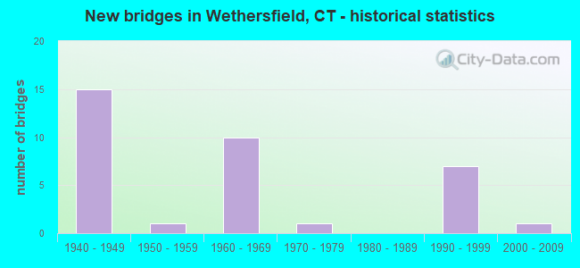
- New bridges - historical statistics
- 151940-1949
- 11950-1959
- 101960-1969
- 11970-1979
- 71990-1999
- 12000-2009

- Reconstructed bridges - Historical Statistics
- 31980-1989
- 31990-1999
- 12000-2009
- 22010-2019


- Bridge Condition - Deck
- 29.4%Good
- 41.2%Satisfactory
- 29.4%Fair

- Bridge Condition - Superstructure
- 10.0%Good
- 25.0%Satisfactory
- 55.0%Fair
- 10.0%Poor

- Bridge Condition - Substructure
- 5.0%Good
- 80.0%Satisfactory
- 15.0%Fair

- Bridge Condition - Channel
- 88.9%Satisfactory
- 11.1%Fair

- Bridge Condition - Culverts
- 16.7%Good
- 83.3%Satisfactory
Find on map >> Show street view
Structure Number: 417, Location: .22MI N OF ACCESS TO I-91 (Lat: 41.714389, Lng: -72.640747), Route carried "on" structure: State highway 3, Year Built: 1959, Year Reconstructed: 2015, Status: Open, Structure Length: 72.94m (239.30ft), Average Daily Traffic: 58,000 (year 2018), Truck Traffic: 8%, Average Future Daily Traffic: 86,182 (year 2038), Design Load: HS 20, Features Intersected: GREAT MEADOW RD & CT RV.
Minimum Vertical Clearance: 30+ m (98+ ft), Kilometerpoint: 18.717, Lanes on structure: 4, Lanes under structure: 2, Base Highway Network: Yes, Owner: State Highway Agency, Approaching Roadway Width: 22.6m (74.1ft), Skew: 30 degrees, Navigation Control: Yes ( Vertical Clearance: 24.4m (80.1ft), Horizontal Clearance: 45.7m (149.9ft)), Material/Design: Steel continuous, Design/Construction: Girder and Floorbeam System, Number Of Spans In Main Unit: 4, Number Of Approach Spans: 10, Length of Maximum Span: 97.2m (318.9ft), Curb or Sidewalk Widths: Left: 0.0m, Right: 1.8m (5.9ft), Curb-To-Curb Width: 19.5m (64.0ft), Out-to-Out Width: 23.5m (77.1ft)
Condition: Deck: Fair, Superstructure: Fair, Substructure: Satisfactory, Channel: Satisfactory, Operating Rating: 82.0 metric tons, Method Used To Determine Operating Rating: Load Factor (LF), Inventory Rating: 49.1 metric tons, Method Used To Determine Inventory Rating: Load Factor (LF), Structural Evaluation: Somewhat better than minimum adequacy, Deck Geometry: Somewhat better than minimum adequacy, Underclear: Meets minimum limits, Waterway Adequacy: Superior to present desirable criteria, Approach Roadway Alignment: Equal to present desirable criteria, Designated Inspection Frequency: Every 24 months, Critical Feature Inspection Frequency: Every 24 months, Underwater Inspection Frequency: Every 24 months, Inspection Date: Febuary 2021, Critical Feature Inspection Date: Febuary 2021, Underwater Inspection Date: Febuary 2021, Deck Structure Type: Concrete Cast-file-Place, Wearing Surface/Protective System: Wearing Surface: Bituminous, Membrane: Preformed Fabric
Find on map >> Show street view
Structure Number: 448, Location: JCT OF 15 AND BERLIN TNPK (Lat: 41.712292, Lng: -72.698347), Route carried "on" structure: State highway 15, Year Built: 1942, Year Reconstructed: 1987, Status: Open, Structure Length: 4.45m (14.60ft), Average Daily Traffic: 12,800 (year 2018), Truck Traffic: 6%, Average Future Daily Traffic: 19,020 (year 2038), Design Load: HS 20+Mod, Features Intersected: ROUTE 314 - BERLIN TNPK.
Minimum Vertical Clearance: 30+ m (98+ ft), Kilometerpoint: 125.593, Lanes on structure: 2, Lanes under structure: 3, Base Highway Network: Yes, Owner: State Highway Agency, Approaching Roadway Width: 11.3m (37.1ft), Skew: 4 degrees, Material/Design: Steel continuous, Design/Construction: Frame, Number Of Spans In Main Unit: 2, Length of Maximum Span: 21.9m (71.9ft), Curb-To-Curb Width: 11.0m (36.1ft), Out-to-Out Width: 12.4m (40.7ft)
Condition: Deck: Good, Superstructure: Poor, Substructure: Satisfactory, Inventory Rating: 73.3 metric tons, Method Used To Determine Inventory Rating: Load Factor (LF), Structural Evaluation: Meets minimum limits, Deck Geometry: Equal to present minimum criteria, Underclear: Meets minimum limits, Approach Roadway Alignment: Equal to present desirable criteria, Designated Inspection Frequency: Every 24 months, Inspection Date: August 2020, Deck Structure Type: Concrete Cast-file-Place, Wearing Surface/Protective System: Wearing Surface: Bituminous, Membrane: Preformed Fabric, Deck Protection: Epoxy Coated Reinforcing
Find on map >> Show street view
Structure Number: 642, Location: 0.3 MI SOUTH HARTFORD TL (Lat: 41.726117, Lng: -72.668261), Route carried "on" structure: US 5, Year Built: 1942, Year Reconstructed: 1986, Status: Open, Structure Length: 4.42m (14.50ft), Average Daily Traffic: 41,200 (year 2015), Truck Traffic: 5%, Average Future Daily Traffic: 61,219 (year 2035), Design Load: HS 20+Mod, Features Intersected: ROUTE 99-SILAS DEANE HWY
Minimum Vertical Clearance: 30+ m (98+ ft), Kilometerpoint: 51.837, Lanes on structure: 4, Lanes under structure: 4, Base Highway Network: Yes, Owner: State Highway Agency, Approaching Roadway Width: 23.8m (78.1ft), Skew: 24 degrees, Material/Design: Steel, Design/Construction: Stringer/Multi-beam, Number Of Spans In Main Unit: 2, Length of Maximum Span: 21.2m (69.6ft), Curb-To-Curb Width: 23.8m (78.1ft), Out-to-Out Width: 25.6m (84.0ft)
Condition: Deck: Good, Superstructure: Fair, Substructure: Satisfactory, Operating Rating: 97.2 metric tons, Method Used To Determine Operating Rating: Load Factor (LF), Inventory Rating: 58.3 metric tons, Method Used To Determine Inventory Rating: Load Factor (LF), Structural Evaluation: Somewhat better than minimum adequacy, Deck Geometry: Superior to present desirable criteria, Underclear: Equal to present minimum criteria, Approach Roadway Alignment: Equal to present desirable criteria, Designated Inspection Frequency: Every 24 months, Inspection Date: March 2021, Deck Structure Type: Concrete Cast-file-Place, Wearing Surface/Protective System: Wearing Surface: Bituminous, Membrane: Preformed Fabric, Deck Protection: Epoxy Coated Reinforcing
Find on map >> Show street view
Structure Number: 806, Location: 0.1 MI N OF NEWINGTON TL (Lat: 41.698333, Lng: -72.704444), Route carried "on" structure: State highway 15, Year Built: 1942, Status: Open, Structure Length: 1.95m (6.40ft), Average Daily Traffic: 45,800 (year 2015), Truck Traffic: 6%, Average Future Daily Traffic: 68,054 (year 2035), Design Load: H 20, Features Intersected: ROUTE 175
Minimum Vertical Clearance: 30+ m (98+ ft), Kilometerpoint: 123.871, Lanes on structure: 4, Lanes under structure: 4, Base Highway Network: Yes, Owner: State Highway Agency, Approaching Roadway Width: 26.5m (86.9ft), Skew: 22 degrees, Material/Design: Concrete, Design/Construction: Frame, Number Of Spans In Main Unit: 1, Length of Maximum Span: 19.5m (64.0ft), Curb-To-Curb Width: 20.2m (66.3ft), Out-to-Out Width: 28.4m (93.2ft)
Condition: Deck: Satisfactory, Superstructure: Satisfactory, Substructure: Satisfactory, Operating Rating: 77.5 metric tons, Method Used To Determine Operating Rating: Load Factor (LF), Inventory Rating: 46.4 metric tons, Method Used To Determine Inventory Rating: Load Factor (LF), Structural Evaluation: Equal to present minimum criteria, Deck Geometry: Better than present minimum criteria, Underclear: High priority of corrective action, Approach Roadway Alignment: Equal to present desirable criteria, Designated Inspection Frequency: Every 24 months, Inspection Date: July 2020, Deck Structure Type: Open Grating, Wearing Surface/Protective System: Wearing Surface: Bituminous
Find on map >> Show street view
Structure Number: 807, Location: 0.4 MILE SOUTH OF RTE 314 (Lat: 41.714756, Lng: -72.691392), Route carried "on" structure: City street , Year Built: 1942, Year Reconstructed: 2018, Status: Open, Structure Length: 2.79m (9.15ft), Average Daily Traffic: 6,172 (year 2020), Truck Traffic: 5%, Average Future Daily Traffic: 9,171 (year 2040), Features Intersected: ROUTE 15 & US ROUTE 5, Facility Carried by Structure: RIDGE ROAD
Minimum Vertical Clearance: 30+ m (98+ ft), Kilometerpoint: 127.895, Lanes on structure: 2, Lanes under structure: 4, Owner: State Highway Agency, Approaching Roadway Width: 12.2m (40.0ft), Skew: 2 degrees, Material/Design: Concrete continuous, Design/Construction: Frame, Number Of Spans In Main Unit: 2, Length of Maximum Span: 13.4m (44.0ft), Curb or Sidewalk Widths: Left: 2.9m (9.5ft), Right: 3.6m (11.8ft), Curb-To-Curb Width: 12.2m (40.0ft), Out-to-Out Width: 20.1m (65.9ft)
Condition: Superstructure: Fair, Substructure: Satisfactory, Operating Rating: 89.8 metric tons, Method Used To Determine Operating Rating: Field evaluation and documented engineering judgment, Inventory Rating: 32.7 metric tons, Method Used To Determine Inventory Rating: Field evaluation and documented engineering judgment, Structural Evaluation: Somewhat better than minimum adequacy, Deck Geometry: Somewhat better than minimum adequacy, Underclear: High priority of corrective action, Approach Roadway Alignment: Equal to present desirable criteria, Designated Inspection Frequency: Every 24 months, Inspection Date: August 2020, Wearing Surface/Protective System: Wearing Surface: Bituminous, Membrane: Other
Find on map >> Show street view
Structure Number: 808, Location: 1 MILE SO. OF HARTFORD TL (Lat: 41.719425, Lng: -72.679222), Route carried "on" structure: State highway 15, Year Built: 1942, Year Reconstructed: 1986, Status: Open, Structure Length: 4.85m (15.91ft), Average Daily Traffic: 35,100 (year 2015), Truck Traffic: 6%, Average Future Daily Traffic: 52,155 (year 2035), Design Load: HS 20+Mod, Features Intersected: FOLLY BROOK BOULEVARD
Minimum Vertical Clearance: 30+ m (98+ ft), Kilometerpoint: 127.219, Lanes on structure: 4, Lanes under structure: 2, Base Highway Network: Yes, Owner: State Highway Agency, Approaching Roadway Width: 23.8m (78.1ft), Skew: 34 degrees, Material/Design: Steel continuous, Design/Construction: Frame, Number Of Spans In Main Unit: 2, Length of Maximum Span: 21.9m (71.9ft), Curb-To-Curb Width: 24.0m (78.7ft), Out-to-Out Width: 25.8m (84.6ft)
Condition: Deck: Good, Superstructure: Fair, Substructure: Satisfactory, Operating Rating: 87.1 metric tons, Method Used To Determine Operating Rating: Load Factor (LF), Inventory Rating: 51.7 metric tons, Method Used To Determine Inventory Rating: Load Factor (LF), Structural Evaluation: Somewhat better than minimum adequacy, Deck Geometry: Superior to present desirable criteria, Underclear: High priority of corrective action, Approach Roadway Alignment: Equal to present desirable criteria, Designated Inspection Frequency: Every 24 months, Inspection Date: October 2020, Deck Structure Type: Concrete Cast-file-Place, Wearing Surface/Protective System: Wearing Surface: Bituminous, Membrane: Preformed Fabric, Deck Protection: Epoxy Coated Reinforcing
Find on map >> Show street view
Structure Number: 809, Location: 0.3 MI SOUTH OF ROUTE 99 (Lat: 41.723161, Lng: -72.672867), Route carried "on" structure: US 5, Year Built: 1942, Year Reconstructed: 2009, Status: Open, Structure Length: 10.21m (33.50ft), Average Daily Traffic: 37,100 (year 2015), Truck Traffic: 8%, Average Future Daily Traffic: 55,127 (year 2035), Design Load: HS 20, Features Intersected: ROUTE 314 & WOLCOTT HILL
Minimum Vertical Clearance: 30+ m (98+ ft), Kilometerpoint: 127.895, Lanes on structure: 4, Lanes under structure: 6, Base Highway Network: Yes, Owner: State Highway Agency, Approaching Roadway Width: 24.1m (79.1ft), Skew: 30 degrees, Material/Design: Steel continuous, Design/Construction: Stringer/Multi-beam, Number Of Spans In Main Unit: 3, Length of Maximum Span: 51.8m (169.9ft), Curb-To-Curb Width: 23.5m (77.1ft), Out-to-Out Width: 25.3m (83.0ft)
Condition: Deck: Fair, Superstructure: Satisfactory, Substructure: Good, Operating Rating: 69.8 metric tons, Method Used To Determine Operating Rating: Load Factor (LF), Inventory Rating: 41.7 metric tons, Method Used To Determine Inventory Rating: Load Factor (LF), Structural Evaluation: Equal to present minimum criteria, Deck Geometry: Superior to present desirable criteria, Underclear: High priority of corrective action, Approach Roadway Alignment: Equal to present desirable criteria, Designated Inspection Frequency: Every 24 months, Critical Feature Inspection Frequency: Every 24 months, Inspection Date: May 2021, Critical Feature Inspection Date: May 2021, Deck Structure Type: Concrete Cast-file-Place, Wearing Surface/Protective System: Wearing Surface: Bituminous, Membrane: Preformed Fabric, Deck Protection: Epoxy Coated Reinforcing
Find on map >> Show street view
Structure Number: 81, Location: 0.1 MILE SOUTH OF RTE. 99 (Lat: 41.724775, Lng: -72.670264), Route carried "on" structure: State highway 15, Year Built: 1943, Status: Open, Structure Length: 1.65m (5.41ft), Average Daily Traffic: 34,900 (year 2019), Truck Traffic: 8%, Average Future Daily Traffic: 51,858 (year 2039), Design Load: H 20, Features Intersected: MC MULLEN AVENUE
Minimum Vertical Clearance: 30+ m (98+ ft), Kilometerpoint: 128.216, Lanes on structure: 5, Lanes under structure: 2, Base Highway Network: Yes, Owner: State Highway Agency, Approaching Roadway Width: 23.5m (77.1ft), Skew: 32 degrees, Material/Design: Concrete, Design/Construction: Frame, Number Of Spans In Main Unit: 1, Length of Maximum Span: 14.3m (46.9ft), Curb-To-Curb Width: 23.5m (77.1ft), Out-to-Out Width: 25.6m (84.0ft)
Condition: Superstructure: Fair, Substructure: Satisfactory, Operating Rating: 75.3 metric tons, Method Used To Determine Operating Rating: Field evaluation and documented engineering judgment, Inventory Rating: 32.7 metric tons, Method Used To Determine Inventory Rating: Field evaluation and documented engineering judgment, Structural Evaluation: Somewhat better than minimum adequacy, Deck Geometry: Equal to present minimum criteria, Underclear: High priority of corrective action, Approach Roadway Alignment: Equal to present desirable criteria, Designated Inspection Frequency: Every 24 months, Inspection Date: September 2021, Wearing Surface/Protective System: Wearing Surface: Bituminous
Find on map >> Show street view
Structure Number: 811, Location: 0.2 MI SO. OF HARTFORD TL (Lat: 41.726775, Lng: -72.667222), Route carried "on" structure: State highway 15, Year Built: 1942, Year Reconstructed: 1990, Status: Open, Structure Length: 9.39m (30.81ft), Average Daily Traffic: 42,200 (year 2015), Truck Traffic: 8%, Average Future Daily Traffic: 62,705 (year 2035), Design Load: H 20, Features Intersected: P&W RR & HARTFORD AVE
Minimum Vertical Clearance: 30+ m (98+ ft), Kilometerpoint: 128.522, Lanes on structure: 5, Lanes under structure: 2, Base Highway Network: Yes, Owner: State Highway Agency, Approaching Roadway Width: 26.8m (87.9ft), Skew: 30 degrees, Material/Design: Steel continuous, Design/Construction: Frame, Number Of Spans In Main Unit: 3, Number Of Approach Spans: 2, Length of Maximum Span: 30.5m (100.1ft), Curb-To-Curb Width: 26.8m (87.9ft), Out-to-Out Width: 28.5m (93.5ft)
Condition: Deck: Satisfactory, Superstructure: Poor, Substructure: Satisfactory, Operating Rating: 57.1 metric tons, Method Used To Determine Operating Rating: Load Factor (LF), Inventory Rating: 34.5 metric tons, Method Used To Determine Inventory Rating: Load Factor (LF), Structural Evaluation: Meets minimum limits, Deck Geometry: Superior to present desirable criteria, Underclear: High priority of corrective action, Approach Roadway Alignment: Equal to present desirable criteria, Designated Inspection Frequency: Every 24 months, Inspection Date: April 2020, Total Project Cost: $5,380,000, Deck Structure Type: Concrete Cast-file-Place, Wearing Surface/Protective System: Wearing Surface: Bituminous, Membrane: Preformed Fabric, Deck Protection: Epoxy Coated Reinforcing
Find on map >> Show street view
Structure Number: 812, Location: 0.26 MILE NORTH OF RTE 99 (Lat: 41.727758, Lng: -72.665900), Route carried "on" structure: State highway 15, Year Built: 1941, Status: Open, Structure Length: 0.74m (2.43ft), Average Daily Traffic: 39,200 (year 2015), Truck Traffic: 5%, Average Future Daily Traffic: 58,247 (year 2035), Features Intersected: FOLLY BROOK
Minimum Vertical Clearance: 30+ m (98+ ft), Kilometerpoint: 128.844, Lanes on structure: 4, Base Highway Network: Yes, Owner: State Highway Agency, Approaching Roadway Width: 24.1m (79.1ft), Skew: 3 degrees, Material/Design: Concrete continuous, Design/Construction: Culvert, Number Of Spans In Main Unit: 2, Length of Maximum Span: 3.5m (11.5ft)
Condition: Channel: Satisfactory, Culverts: Satisfactory, Structural Evaluation: Equal to present minimum criteria, Waterway Adequacy: Better than present minimum criteria, Approach Roadway Alignment: Equal to present desirable criteria, Designated Inspection Frequency: Every 24 months, Inspection Date: August 2021
Find on map >> Show street view
Structure Number: 1209, Location: 0.3 MI N OF ROUTE 99 (Lat: 41.728544, Lng: -72.665153), Route carried "on" structure: State highway 15, Year Built: 1941, Status: Open, Structure Length: 1.22m (4.00ft), Average Daily Traffic: 39,200 (year 2018), Truck Traffic: 6%, Average Future Daily Traffic: 58,247 (year 2038), Features Intersected: PUMPING STATION OUTLET
Minimum Vertical Clearance: 30+ m (98+ ft), Kilometerpoint: 128.941, Lanes on structure: 4, Base Highway Network: Yes, Owner: State Highway Agency, Approaching Roadway Width: 25.6m (84.0ft), Skew: 30 degrees, Material/Design: Concrete, Design/Construction: Arch - Deck, Number Of Spans In Main Unit: 1, Length of Maximum Span: 12.2m (40.0ft)
Condition: Superstructure: Fair, Substructure: Satisfactory, Channel: Satisfactory, Structural Evaluation: Somewhat better than minimum adequacy, Waterway Adequacy: Equal to present desirable criteria, Approach Roadway Alignment: Equal to present desirable criteria, Designated Inspection Frequency: Every 24 months, Inspection Date: May 2020
Find on map >> Show street view
Structure Number: 145, Location: 200' NO. OF ROCKY HILL TL (Lat: 41.684975, Lng: -72.651114), Route carried "on" structure: Interstate 91, Year Built: 1964, Status: Open, Structure Length: 0.76m (2.49ft), Average Daily Traffic: 149,400 (year 2015), Truck Traffic: 9%, Average Future Daily Traffic: 221,993 (year 2035), Features Intersected: GOFF BROOK
Minimum Vertical Clearance: 30+ m (98+ ft), Kilometerpoint: 51.531, Lanes on structure: 7, Base Highway Network: Yes, Owner: State Highway Agency, Approaching Roadway Width: 35.4m (116.1ft), Skew: 2 degrees, Material/Design: Concrete continuous, Design/Construction: Culvert, Number Of Spans In Main Unit: 2, Length of Maximum Span: 3.6m (11.8ft)
Condition: Channel: Fair, Culverts: Satisfactory, Structural Evaluation: Equal to present minimum criteria, Waterway Adequacy: Better than present minimum criteria, Approach Roadway Alignment: Equal to present desirable criteria, Designated Inspection Frequency: Every 24 months, Inspection Date: April 2021
Find on map >> Show street view
Structure Number: 1451, Location: 0.1 MI N OF ROCKY HILL TL (Lat: 41.686303, Lng: -72.650203), Route carried "on" structure: Interstate 91, Year Built: 1964, Status: Open, Structure Length: 4.10m (13.45ft), Average Daily Traffic: 73,900 (year 2015), Truck Traffic: 9%, Average Future Daily Traffic: 109,808 (year 2035), Design Load: HS 20, Features Intersected: PROVIDENCE& WORCESTER RR
Minimum Vertical Clearance: 30+ m (98+ ft), Kilometerpoint: 51.676, Lanes on structure: 4, Base Highway Network: Yes, Owner: State Highway Agency, Approaching Roadway Width: 19.8m (65.0ft), Skew: 3 degrees, Material/Design: Steel, Design/Construction: Stringer/Multi-beam, Number Of Spans In Main Unit: 3, Length of Maximum Span: 13.2m (43.3ft), Curb-To-Curb Width: 19.8m (65.0ft), Out-to-Out Width: 20.9m (68.6ft)
Condition: Deck: Satisfactory, Superstructure: Fair, Substructure: Fair, Operating Rating: 43.7 metric tons, Method Used To Determine Operating Rating: Load and Resistance Factor Rating (LRFR) rating reported by rating factor(RF) method using HL-93 loadings, Inventory Rating: 33.7 metric tons, Method Used To Determine Inventory Rating: Load and Resistance Factor Rating (LRFR) rating reported by rating factor(RF) method using HL-93 loadings, Structural Evaluation: Somewhat better than minimum adequacy, Deck Geometry: Equal to present minimum criteria, Underclear: High priority of corrective action, Approach Roadway Alignment: Equal to present desirable criteria, Designated Inspection Frequency: Every 24 months, Inspection Date: July 2021, Deck Structure Type: Concrete Cast-file-Place, Wearing Surface/Protective System: Wearing Surface: Bituminous, Membrane: Preformed Fabric
Find on map >> Show street view
Structure Number: 1452, Location: 0.1 MI N OF ROCKY HILL TL (Lat: 41.686572, Lng: -72.650431), Route carried "on" structure: Interstate 91, Year Built: 1964, Status: Open, Structure Length: 4.16m (13.65ft), Average Daily Traffic: 75,500 (year 2015), Truck Traffic: 9%, Average Future Daily Traffic: 112,185 (year 2035), Design Load: HS 20, Features Intersected: PROVIDENCE& WORCESTER RR
Minimum Vertical Clearance: 30+ m (98+ ft), Kilometerpoint: 51.692, Lanes on structure: 4, Base Highway Network: Yes, Owner: State Highway Agency, Approaching Roadway Width: 19.8m (65.0ft), Skew: 3 degrees, Material/Design: Steel, Design/Construction: Stringer/Multi-beam, Number Of Spans In Main Unit: 3, Length of Maximum Span: 13.2m (43.3ft), Curb-To-Curb Width: 19.8m (65.0ft), Out-to-Out Width: 20.9m (68.6ft)
Condition: Deck: Satisfactory, Superstructure: Fair, Substructure: Fair, Operating Rating: 44.1 metric tons, Method Used To Determine Operating Rating: Load and Resistance Factor Rating (LRFR) rating reported by rating factor(RF) method using HL-93 loadings, Inventory Rating: 33.7 metric tons, Method Used To Determine Inventory Rating: Load and Resistance Factor Rating (LRFR) rating reported by rating factor(RF) method using HL-93 loadings, Structural Evaluation: Somewhat better than minimum adequacy, Deck Geometry: Equal to present minimum criteria, Underclear: High priority of corrective action, Approach Roadway Alignment: Equal to present desirable criteria, Designated Inspection Frequency: Every 24 months, Inspection Date: July 2021, Deck Structure Type: Concrete Cast-file-Place, Wearing Surface/Protective System: Wearing Surface: Bituminous, Membrane: Preformed Fabric
Find on map >> Show street view
Structure Number: 1453, Location: APPROX 1 M SO OF ROUTE 3 (Lat: 41.686847, Lng: -72.649892), Route carried "on" structure: Interstate 91, Year Built: 1964, Status: Open, Structure Length: 6.16m (20.21ft), Average Daily Traffic: 73,900 (year 2015), Truck Traffic: 14%, Average Future Daily Traffic: 109,808 (year 2035), Design Load: HS 20, Features Intersected: MIDDLETOWN AVENUE
Minimum Vertical Clearance: 30+ m (98+ ft), Kilometerpoint: 51.740, Lanes on structure: 4, Lanes under structure: 2, Base Highway Network: Yes, Owner: State Highway Agency, Approaching Roadway Width: 19.8m (65.0ft), Skew: 5 degrees, Material/Design: Steel, Design/Construction: Stringer/Multi-beam, Number Of Spans In Main Unit: 3, Length of Maximum Span: 26.2m (86.0ft), Curb-To-Curb Width: 19.8m (65.0ft), Out-to-Out Width: 20.9m (68.6ft)
Condition: Deck: Satisfactory, Superstructure: Satisfactory, Substructure: Satisfactory, Operating Rating: 89.2 metric tons, Method Used To Determine Operating Rating: Load Factor (LF), Inventory Rating: 53.5 metric tons, Method Used To Determine Inventory Rating: Load Factor (LF), Structural Evaluation: Equal to present minimum criteria, Deck Geometry: Equal to present minimum criteria, Underclear: Better than present minimum criteria, Approach Roadway Alignment: Equal to present desirable criteria, Designated Inspection Frequency: Every 24 months, Inspection Date: April 2021, Deck Structure Type: Concrete Cast-file-Place, Wearing Surface/Protective System: Wearing Surface: Bituminous
Find on map >> Show street view
Structure Number: 1455, Location: 0.5 MI N OF ROCKY HILL TL (Lat: 41.691797, Lng: -72.647389), Route carried "on" structure: Interstate 91, Year Built: 1964, Status: Open, Structure Length: 0.76m (2.49ft), Average Daily Traffic: 143,400 (year 2019), Truck Traffic: 9%, Average Future Daily Traffic: 213,078 (year 2039), Features Intersected: BEAVER BROOK
Minimum Vertical Clearance: 30+ m (98+ ft), Kilometerpoint: 52.336, Lanes on structure: 8, Base Highway Network: Yes, Owner: State Highway Agency, Approaching Roadway Width: 49.1m (161.1ft), Skew: 2 degrees, Material/Design: Concrete continuous, Design/Construction: Culvert, Number Of Spans In Main Unit: 2, Length of Maximum Span: 3.7m (12.1ft)
Condition: Channel: Satisfactory, Culverts: Satisfactory, Structural Evaluation: Equal to present minimum criteria, Waterway Adequacy: Equal to present desirable criteria, Approach Roadway Alignment: Superior to present desirable criteria, Designated Inspection Frequency: Every 24 months, Underwater Inspection Frequency: Every 24 months, Inspection Date: December 2021, Underwater Inspection Date: December 2021
Find on map >> Show street view
Structure Number: 1456, Location: 0.5 MILE SOUTH OF EXIT 25 (Lat: 41.698300, Lng: -72.643925), Route carried "on" structure: Interstate 91, Year Built: 1964, Status: Open, Structure Length: 3.46m (11.35ft), Average Daily Traffic: 74,700 (year 2015), Truck Traffic: 14%, Average Future Daily Traffic: 110,997 (year 2035), Design Load: HS 20, Features Intersected: ELM STREET
Minimum Vertical Clearance: 30+ m (98+ ft), Kilometerpoint: 53.108, Lanes on structure: 4, Lanes under structure: 2, Base Highway Network: Yes, Owner: State Highway Agency, Approaching Roadway Width: 19.8m (65.0ft), Skew: 1 degrees, Material/Design: Steel, Design/Construction: Stringer/Multi-beam, Number Of Spans In Main Unit: 3, Length of Maximum Span: 10.9m (35.8ft), Curb-To-Curb Width: 19.8m (65.0ft), Out-to-Out Width: 20.9m (68.6ft)
Condition: Deck: Fair, Superstructure: Fair, Substructure: Fair, Operating Rating: 34.0 metric tons, Method Used To Determine Operating Rating: Load and Resistance Factor Rating (LRFR) rating reported by rating factor(RF) method using HL-93 loadings, Inventory Rating: 26.2 metric tons, Method Used To Determine Inventory Rating: Load and Resistance Factor Rating (LRFR) rating reported by rating factor(RF) method using HL-93 loadings, Structural Evaluation: Somewhat better than minimum adequacy, Deck Geometry: Equal to present minimum criteria, Underclear: High priority of corrective action, Approach Roadway Alignment: Equal to present desirable criteria, Designated Inspection Frequency: Every 24 months, Inspection Date: June 2020, Deck Structure Type: Concrete Cast-file-Place, Wearing Surface/Protective System: Wearing Surface: Bituminous, Membrane: Preformed Fabric
Find on map >> Show street view
Structure Number: 1457, Location: 0.7 MILE SOUTH OF ROUTE 3 (Lat: 41.698408, Lng: -72.644258), Route carried "on" structure: Interstate 91, Year Built: 1964, Status: Open, Structure Length: 3.14m (10.30ft), Average Daily Traffic: 75,450 (year 2015), Truck Traffic: 14%, Average Future Daily Traffic: 112,111 (year 2035), Design Load: HS 20, Features Intersected: ELM STREET
Minimum Vertical Clearance: 30+ m (98+ ft), Kilometerpoint: 53.124, Lanes on structure: 4, Lanes under structure: 2, Base Highway Network: Yes, Owner: State Highway Agency, Approaching Roadway Width: 19.5m (64.0ft), Skew: 1 degrees, Material/Design: Steel, Design/Construction: Stringer/Multi-beam, Number Of Spans In Main Unit: 3, Length of Maximum Span: 10.6m (34.8ft), Curb-To-Curb Width: 19.2m (63.0ft), Out-to-Out Width: 20.7m (67.9ft)
Condition: Deck: Fair, Superstructure: Satisfactory, Substructure: Satisfactory, Operating Rating: 41.1 metric tons, Method Used To Determine Operating Rating: Load and Resistance Factor Rating (LRFR) rating reported by rating factor(RF) method using HL-93 loadings, Inventory Rating: 31.8 metric tons, Method Used To Determine Inventory Rating: Load and Resistance Factor Rating (LRFR) rating reported by rating factor(RF) method using HL-93 loadings, Structural Evaluation: Equal to present minimum criteria, Deck Geometry: Somewhat better than minimum adequacy, Underclear: Meets minimum limits, Approach Roadway Alignment: Equal to present desirable criteria, Designated Inspection Frequency: Every 24 months, Inspection Date: June 2020, Deck Structure Type: Concrete Cast-file-Place, Wearing Surface/Protective System: Wearing Surface: Bituminous, Membrane: Preformed Fabric
Find on map >> Show street view
Structure Number: 1459, Location: 1.2 MILE S OF HARTFORD TL (Lat: 41.714217, Lng: -72.648139), Route carried "on" structure: Interstate 91, Year Built: 1964, Year Reconstructed: 1995, Status: Open, Structure Length: 3.23m (10.60ft), Average Daily Traffic: 123,000 (year 2015), Truck Traffic: 9%, Average Future Daily Traffic: 182,766 (year 2035), Design Load: HS 20, Features Intersected: GREAT MEADOW ROAD
Minimum Vertical Clearance: 30+ m (98+ ft), Kilometerpoint: 54.927, Lanes on structure: 7, Lanes under structure: 2, Base Highway Network: Yes, Owner: State Highway Agency, Approaching Roadway Width: 35.7m (117.1ft), Skew: 30 degrees, Material/Design: Steel, Design/Construction: Stringer/Multi-beam, Number Of Spans In Main Unit: 3, Length of Maximum Span: 13.4m (44.0ft), Curb-To-Curb Width: 35.7m (117.1ft), Out-to-Out Width: 38.3m (125.7ft)
Condition: Deck: Satisfactory, Superstructure: Fair, Substructure: Satisfactory, Operating Rating: 44.7 metric tons, Method Used To Determine Operating Rating: Load and Resistance Factor Rating (LRFR) rating reported by rating factor(RF) method using HL-93 loadings, Inventory Rating: 34.3 metric tons, Method Used To Determine Inventory Rating: Load and Resistance Factor Rating (LRFR) rating reported by rating factor(RF) method using HL-93 loadings, Structural Evaluation: Somewhat better than minimum adequacy, Deck Geometry: Superior to present desirable criteria, Underclear: Somewhat better than minimum adequacy, Approach Roadway Alignment: Equal to present desirable criteria, Designated Inspection Frequency: Every 24 months, Inspection Date: May 2021, Deck Structure Type: Concrete Cast-file-Place, Wearing Surface/Protective System: Wearing Surface: Bituminous, Membrane: Preformed Fabric
Find on map >> Show street view
Structure Number: 146, Location: .4 MI. S HARTFORD TOWN LN (Lat: 41.725619, Lng: -72.654039), Route carried "on" structure: Interstate 91, Year Built: 1964, Year Reconstructed: 1997, Status: Open, Structure Length: 10.31m (33.83ft), Average Daily Traffic: 132,000 (year 2015), Truck Traffic: 9%, Average Future Daily Traffic: 196,139 (year 2035), Design Load: HS 20, Features Intersected: WETHERSFIELD COVE
Minimum Vertical Clearance: 30+ m (98+ ft), Kilometerpoint: 56.279, Lanes on structure: 7, Base Highway Network: Yes, Owner: State Highway Agency, Approaching Roadway Width: 33.8m (110.9ft), Skew: 34 degrees, Navigation Control: Yes ( Vertical Clearance: 11.6m (38.1ft), Horizontal Clearance: 18.3m (60.0ft)), Material/Design: Steel continuous, Design/Construction: Stringer/Multi-beam, Number Of Spans In Main Unit: 3, Length of Maximum Span: 41.5m (136.2ft), Curb-To-Curb Width: 32.6m (107.0ft), Out-to-Out Width: 35.3m (115.8ft)
Condition: Deck: Fair, Superstructure: Fair, Substructure: Satisfactory, Channel: Satisfactory, Operating Rating: 74.4 metric tons, Method Used To Determine Operating Rating: Load Factor (LF), Inventory Rating: 44.4 metric tons, Method Used To Determine Inventory Rating: Load Factor (LF), Structural Evaluation: Somewhat better than minimum adequacy, Deck Geometry: Better than present minimum criteria, Waterway Adequacy: Equal to present desirable criteria, Approach Roadway Alignment: Equal to present desirable criteria, Designated Inspection Frequency: Every 24 months, Underwater Inspection Frequency: Every 24 months, Inspection Date: November 2020, Underwater Inspection Date: September 2020, Deck Structure Type: Concrete Cast-file-Place, Wearing Surface/Protective System: Wearing Surface: Bituminous, Membrane: Preformed Fabric
Find on map >> Show street view
Structure Number: 4191, Location: 1250 FEET WEST OF ROUTE 3 (Lat: 41.682422, Lng: -72.669267), Route carried "on" structure: City street , Year Built: 1961, Status: Open, Structure Length: 0.94m (3.08ft), Average Daily Traffic: 5,306 (year 2020), Truck Traffic: 3%, Average Future Daily Traffic: 7,884 (year 2040), Features Intersected: TWO STONE BROOK, Facility Carried by Structure: GRISWOLD ROAD
Minimum Vertical Clearance: 30+ m (98+ ft), Kilometerpoint: 0.692, Lanes on structure: 2, Owner: Town or Township Highway Agency, Approaching Roadway Width: 12.8m (42.0ft), Material/Design: Concrete continuous, Design/Construction: Culvert, Number Of Spans In Main Unit: 2, Length of Maximum Span: 4.6m (15.1ft), Curb or Sidewalk Widths: Left: 1.4m (4.6ft), Right: 1.4m (4.6ft), Curb-To-Curb Width: 12.9m (42.3ft), Out-to-Out Width: 16.4m (53.8ft)
Condition: Channel: Satisfactory, Culverts: Satisfactory, Operating Rating: 50.2 metric tons, Method Used To Determine Operating Rating: Load and Resistance Factor Rating (LRFR) rating reported by rating factor(RF) method using HL-93 loadings, Inventory Rating: 38.6 metric tons, Method Used To Determine Inventory Rating: Load and Resistance Factor Rating (LRFR) rating reported by rating factor(RF) method using HL-93 loadings, Structural Evaluation: Equal to present minimum criteria, Deck Geometry: Somewhat better than minimum adequacy, Waterway Adequacy: Better than present minimum criteria, Approach Roadway Alignment: Equal to present desirable criteria, Designated Inspection Frequency: Every 24 months, Inspection Date: April 2020
Find on map >> Show street view
Structure Number: 6087, Location: 200' W OF FOLLYBROOK BLVD (Lat: 41.717050, Lng: -72.680453), Route carried "on" structure: City street , Year Built: 1977, Status: Open, Structure Length: 0.67m (2.20ft), Average Daily Traffic: 67 (year 2018), Truck Traffic: 7%, Average Future Daily Traffic: 100 (year 2038), Features Intersected: FOLLY BROOK, Facility Carried by Structure: SPRUCE STREET
Minimum Vertical Clearance: 30+ m (98+ ft), Kilometerpoint: 0.000, Lanes on structure: 2, Owner: Town or Township Highway Agency, Approaching Roadway Width: 9.1m (29.9ft), Skew: 1 degrees, Material/Design: Concrete, Design/Construction: Culvert, Number Of Spans In Main Unit: 2, Length of Maximum Span: 3.0m (9.8ft), Curb or Sidewalk Widths: Left: 1.4m (4.6ft), Right: 0.0m
Condition: Channel: Satisfactory, Culverts: Good, Operating Rating: 42.6 metric tons, Method Used To Determine Operating Rating: Field evaluation and documented engineering judgment, Inventory Rating: 32.7 metric tons, Method Used To Determine Inventory Rating: Field evaluation and documented engineering judgment, Structural Evaluation: Better than present minimum criteria, Waterway Adequacy: Better than present minimum criteria, Approach Roadway Alignment: Equal to present desirable criteria, Designated Inspection Frequency: Every 48 months, Inspection Date: April 2018
Find on map >> Show street view
Structure Number: 6288, Location: 0.8 MILE NORTH OF RTE. 99 (Lat: 41.705000, Lng: -72.647681), Route carried "on" structure: State highway 3, Year Built: 1994, Status: Open, Structure Length: 5.18m (16.99ft), Average Daily Traffic: 9,600 (year 2018), Truck Traffic: 6%, Average Future Daily Traffic: 14,265 (year 2038), Design Load: HS 20, Features Intersected: I-91 TR 802
Minimum Vertical Clearance: 30+ m (98+ ft), Kilometerpoint: 17.864, Lanes on structure: 2, Lanes under structure: 1, Base Highway Network: Yes, Owner: State Highway Agency, Approaching Roadway Width: 12.2m (40.0ft), Skew: 4 degrees, Material/Design: Steel, Design/Construction: Box Beam or Girders - Single/Spread, Number Of Spans In Main Unit: 1, Length of Maximum Span: 48.8m (160.1ft), Curb-To-Curb Width: 12.2m (40.0ft), Out-to-Out Width: 13.3m (43.6ft)
Condition: Deck: Good, Superstructure: Good, Substructure: Satisfactory, Inventory Rating: 82.7 metric tons, Method Used To Determine Inventory Rating: Load Factor (LF), Structural Evaluation: Equal to present minimum criteria, Deck Geometry: Better than present minimum criteria, Underclear: Superior to present desirable criteria, Approach Roadway Alignment: Equal to present desirable criteria, Designated Inspection Frequency: Every 24 months, Critical Feature Inspection Frequency: Every 24 months, Inspection Date: December 2020, Critical Feature Inspection Date: December 2020, Deck Structure Type: Concrete Cast-file-Place, Wearing Surface/Protective System: Wearing Surface: Bituminous, Membrane: Preformed Fabric, Deck Protection: Epoxy Coated Reinforcing
Find on map >> Show street view
Structure Number: 6289, Location: OVER I-91 (Lat: 41.707417, Lng: -72.645200), Route carried "on" structure: State highway 3, Year Built: 1994, Status: Open, Structure Length: 12.89m (42.29ft), Average Daily Traffic: 38,431 (year 2021), Truck Traffic: 6%, Average Future Daily Traffic: 57,105 (year 2041), Design Load: HS 20, Features Intersected: INTERSTATE-91
Minimum Vertical Clearance: 30+ m (98+ ft), Kilometerpoint: 18.153, Lanes on structure: 3, Lanes under structure: 6, Base Highway Network: Yes, Owner: State Highway Agency, Approaching Roadway Width: 20.7m (67.9ft), Skew: 5 degrees, Material/Design: Steel, Design/Construction: Box Beam or Girders - Single/Spread, Number Of Spans In Main Unit: 2, Length of Maximum Span: 64.0m (210.0ft), Curb-To-Curb Width: 20.7m (67.9ft), Out-to-Out Width: 21.9m (71.9ft)
Condition: Deck: Satisfactory, Superstructure: Satisfactory, Substructure: Satisfactory, Operating Rating: 39.2 metric tons, Method Used To Determine Operating Rating: Load and Resistance Factor Rating (LRFR) rating reported by rating factor(RF) method using HL-93 loadings, Inventory Rating: 30.1 metric tons, Method Used To Determine Inventory Rating: Load and Resistance Factor Rating (LRFR) rating reported by rating factor(RF) method using HL-93 loadings, Structural Evaluation: Equal to present minimum criteria, Deck Geometry: Superior to present desirable criteria, Underclear: Equal to present minimum criteria, Approach Roadway Alignment: Equal to present desirable criteria, Designated Inspection Frequency: Every 24 months, Inspection Date: Febuary 2021, Deck Structure Type: Concrete Cast-file-Place, Wearing Surface/Protective System: Wearing Surface: Bituminous, Membrane: Preformed Fabric, Deck Protection: Epoxy Coated Reinforcing
Find on map >> Show street view
Structure Number: 629, Location: ROUTE 3 SB OVER I-91 (Lat: 41.709086, Lng: -72.645292), Route carried "on" structure: State highway 3, Year Built: 1994, Status: Open, Structure Length: 19.81m (64.99ft), Average Daily Traffic: 24,700 (year 2018), Truck Traffic: 6%, Average Future Daily Traffic: 36,702 (year 2038), Design Load: HS 20, Features Intersected: INTERSTATE-91 & TR804
Minimum Vertical Clearance: 30+ m (98+ ft), Kilometerpoint: 18.250, Lanes on structure: 2, Lanes under structure: 7, Base Highway Network: Yes, Owner: State Highway Agency, Approaching Roadway Width: 12.2m (40.0ft), Skew: 4 degrees, Material/Design: Steel, Design/Construction: Box Beam or Girders - Single/Spread, Number Of Spans In Main Unit: 3, Length of Maximum Span: 70.1m (230.0ft), Curb-To-Curb Width: 12.2m (40.0ft), Out-to-Out Width: 13.4m (44.0ft)
Condition: Deck: Good, Superstructure: Good, Substructure: Satisfactory, Operating Rating: 63.2 metric tons, Method Used To Determine Operating Rating: Load and Resistance Factor Rating (LRFR) rating reported by rating factor(RF) method using HL-93 loadings, Inventory Rating: 48.6 metric tons, Method Used To Determine Inventory Rating: Load and Resistance Factor Rating (LRFR) rating reported by rating factor(RF) method using HL-93 loadings, Structural Evaluation: Equal to present minimum criteria, Deck Geometry: Better than present minimum criteria, Underclear: Equal to present minimum criteria, Approach Roadway Alignment: Equal to present desirable criteria, Designated Inspection Frequency: Every 24 months, Inspection Date: Febuary 2021, Deck Structure Type: Concrete Cast-file-Place, Wearing Surface/Protective System: Wearing Surface: Bituminous, Membrane: Preformed Fabric, Deck Protection: Epoxy Coated Reinforcing
Find on map >> Show street view
Structure Number: 6822, Location: 250' N OF SPRING ST (Lat: 41.699956, Lng: -72.654736), Route carried "on" structure: State highway 3, Year Built: 2002, Status: Open, Structure Length: 0.85m (2.79ft), Average Daily Traffic: 20,300 (year 2018), Truck Traffic: 8%, Average Future Daily Traffic: 30,164 (year 2038), Design Load: HL 93, Features Intersected: BEAVER BROOK
Minimum Vertical Clearance: 30+ m (98+ ft), Kilometerpoint: 17.059, Lanes on structure: 5, Base Highway Network: Yes, Owner: State Highway Agency, Approaching Roadway Width: 21.0m (68.9ft), Skew: 1 degrees, Material/Design: Concrete, Design/Construction: Culvert, Number Of Spans In Main Unit: 2, Length of Maximum Span: 3.7m (12.1ft), Curb-To-Curb Width: 20.9m (68.6ft), Out-to-Out Width: 33.5m (109.9ft)
Condition: Channel: Satisfactory, Culverts: Satisfactory, Operating Rating: 42.4 metric tons, Method Used To Determine Operating Rating: Load and Resistance Factor Rating (LRFR) rating reported by rating factor(RF) method using HL-93 loadings, Inventory Rating: 32.7 metric tons, Method Used To Determine Inventory Rating: Load and Resistance Factor Rating (LRFR) rating reported by rating factor(RF) method using HL-93 loadings, Structural Evaluation: Equal to present minimum criteria, Deck Geometry: Meets minimum limits, Waterway Adequacy: Equal to present desirable criteria, Approach Roadway Alignment: Equal to present desirable criteria, Designated Inspection Frequency: Every 24 months, Underwater Inspection Frequency: Every 24 months, Inspection Date: July 2021, Underwater Inspection Date: July 2021
Find on map >> Show street view
Structure Number: 448, Location: JCT OF 15 AND BERLIN TNPK (Lat: 41.712292, Lng: -72.698347), Route carried "under" structure: State highway 314, Year Built: 1942, Structure Length: 0. m, Average Daily Traffic: 12,800 (year 2018), Truck Traffic: 9%, Features Intersected: ROUTE 314 - BERLIN TNPK., Facility Carried by Structure: ROUTE 15 SB
Minimum Vertical Clearance: 5.26m (17.26ft), Kilometerpoint: 0.161, Lanes on structure: 2, Lanes under structure: 3, Material/Design: Steel continuous, Design/Construction: Frame, Length of Maximum Span: 21.9m (71.9ft)
Find on map >> Show street view
Structure Number: 642, Location: 0.3 MI SOUTH HARTFORD TL (Lat: 41.726117, Lng: -72.668261), Route carried "under" structure: State highway 99, Year Built: 1942, Structure Length: 0. m, Average Daily Traffic: 15,600 (year 2018), Truck Traffic: 6%, Features Intersected: ROUTE 99-SILAS DEANE HWY, Facility Carried by Structure: US ROUTE 5 &RTE 15
Minimum Vertical Clearance: 6.30m (20.67ft), Kilometerpoint: 16.898, Lanes on structure: 4, Lanes under structure: 4, Material/Design: Steel, Design/Construction: Stringer/Multi-beam, Length of Maximum Span: 21.2m (69.6ft)
Find on map >> Show street view
Structure Number: 806, Location: 0.1 MI N OF NEWINGTON TL (Lat: 41.698333, Lng: -72.704444), Route carried "under" structure: State highway 175, Year Built: 1942, Structure Length: 0. m, Average Daily Traffic: 19,700 (year 2015), Truck Traffic: 5%, Features Intersected: ROUTE 175, Facility Carried by Structure: ROUTE 15 & US 5
Minimum Vertical Clearance: 4.95m (16.24ft), Kilometerpoint: 6.212, Lanes on structure: 4, Lanes under structure: 4, Material/Design: Concrete, Design/Construction: Frame, Length of Maximum Span: 19.5m (64.0ft)
Find on map >> Show street view
Structure Number: 807, Location: 0.4 MILE SOUTH OF RTE 314 (Lat: 41.714756, Lng: -72.691392), Route carried "under" structure: State highway 15, Year Built: 1942, Structure Length: 0. m, Average Daily Traffic: 35,100 (year 2016), Truck Traffic: 10%, Features Intersected: ROUTE 15 & US ROUTE 5, Facility Carried by Structure: RIDGE ROAD
Minimum Vertical Clearance: 4.70m (15.42ft), Kilometerpoint: 126.140, Lanes on structure: 2, Lanes under structure: 4, Material/Design: Concrete continuous, Design/Construction: Frame, Length of Maximum Span: 13.4m (44.0ft)
Find on map >> Show street view
Structure Number: 809, Location: 0.3 MI SOUTH OF ROUTE 99 (Lat: 41.723161, Lng: -72.672867), Route carried "under" structure: State highway 314, Year Built: 1942, Structure Length: 0. m, Average Daily Traffic: 9,400 (year 2018), Truck Traffic: 5%, Features Intersected: ROUTE 314 & WOLCOTT HILL, Facility Carried by Structure: U.S. ROUTE 5 & ROU
Minimum Vertical Clearance: 5.39m (17.68ft), Kilometerpoint: 2.897, Lanes on structure: 4, Lanes under structure: 4, Material/Design: Steel continuous, Design/Construction: Stringer/Multi-beam, Length of Maximum Span: 51.8m (169.9ft)
Find on map >> Show street view
Structure Number: 6288, Location: 0.8 MILE NORTH OF RTE. 99 (Lat: 41.705000, Lng: -72.647681), Route carried "under" structure: Ramp State highway 3, Year Built: 1994, Structure Length: 0. m, Average Daily Traffic: 15,500 (year 2018), Truck Traffic: 6%, Features Intersected: I-91 TR 802
Minimum Vertical Clearance: 5.61m (18.41ft), Kilometerpoint: 0.000, Lanes on structure: 2, Lanes under structure: 1, Material/Design: Steel, Design/Construction: Box Beam or Girders - Single/Spread, Length of Maximum Span: 48.8m (160.1ft)
Find on map >> Show street view
Structure Number: 6289, Location: OVER I-91 (Lat: 41.707417, Lng: -72.645200), Route carried "under" structure: Interstate 91, Year Built: 1994, Structure Length: 0. m, Average Daily Traffic: 121,900 (year 2015), Truck Traffic: 14%, Features Intersected: INTERSTATE-91, Facility Carried by Structure: ROUTE 3 NORTHBOUND
Minimum Vertical Clearance: 6.40m (21.00ft), Kilometerpoint: 54.187, Lanes on structure: 3, Lanes under structure: 6, Material/Design: Steel, Design/Construction: Box Beam or Girders - Single/Spread, Length of Maximum Span: 64.0m (210.0ft)
Find on map >> Show street view
Structure Number: 629, Location: ROUTE 3 SB OVER I-91 (Lat: 41.709086, Lng: -72.645292), Route carried "under" structure: Interstate 91, Year Built: 1994, Structure Length: 0. m, Average Daily Traffic: 121,900 (year 2015), Truck Traffic: 14%, Features Intersected: INTERSTATE-91 & TR804, Facility Carried by Structure: ROUTE 3 SOUTHBOUND
Minimum Vertical Clearance: 7.62m (25.00ft), Kilometerpoint: 54.331, Lanes on structure: 2, Lanes under structure: 6, Material/Design: Steel, Design/Construction: Box Beam or Girders - Single/Spread, Length of Maximum Span: 70.1m (230.0ft)
Find on map >> Show street view
Structure Number: 629, Location: ROUTE 3 SB OVER I-91 (Lat: 41.709086, Lng: -72.645292), Route carried "under" structure: Ramp Interstate 91, Year Built: 1994, Structure Length: 0. m, Average Daily Traffic: 2,100 (year 2015), Truck Traffic: 14%, Features Intersected: INTERSTATE-91 & TR804, Facility Carried by Structure: ROUTE 3 SOUTHBOUND
Minimum Vertical Clearance: 5.28m (17.32ft), Kilometerpoint: 0.000, Lanes on structure: 2, Lanes under structure: 1, Material/Design: Steel, Design/Construction: Box Beam or Girders - Single/Spread, Length of Maximum Span: 70.1m (230.0ft)