Bridge Statistics for Westwood Lakes, Florida (FL)
Condition, Traffic, Stress, Structural Evaluation, Project Costs
- National Bridge Inventory (NBI) Statistics
- 21Number of bridges
- 230ft / 69.8mTotal length
- 1,197,670Total average daily traffic
- 90,337Total average daily truck traffic
- National Bridge Inventory (NBI) Registered Bridges for Westwood Lakes
- No street view available for this location
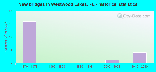
- New bridges - historical statistics
- 161970-1979
- 12000-2009
- 42010-2019

- Reconstructed bridges - Historical Statistics
- 82010-2019
- 22020-2022

- Bridge Condition - Deck
- 7.7%Excellent
- 38.5%Very good
- 53.8%Good
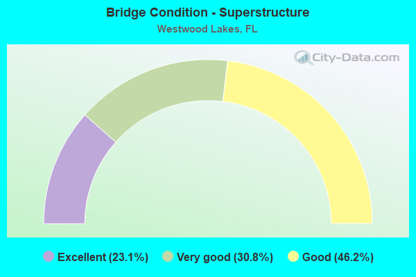
- Bridge Condition - Superstructure
- 23.1%Excellent
- 30.8%Very good
- 46.2%Good

- Bridge Condition - Substructure
- 7.7%Excellent
- 84.6%Very good
- 7.7%Good

- Bridge Condition - Channel
- 28.6%Excellent
- 57.1%Very good
- 14.3%Good
Find on map >> Show street view
Structure Number: 870204, Location: 8.7 MILES NORTH OF US-1 (Lat: 25.700906, Lng: -80.383833), Route carried "on" structure: State highway 821, Year Built: 1973, Year Reconstructed: 2020, Status: Open, Structure Length: 5.49m (18.01ft), Average Daily Traffic: 120,600 (year 2021), Truck Traffic: 8%, Average Future Daily Traffic: 193,100 (year 2042), Design Load: HL 93, Features Intersected: SW 72 ST SUNSET DR
Minimum Vertical Clearance: 30+ m (98+ ft), Kilometerpoint: 34.660, Lanes on structure: 5, Lanes under structure: 5, Base Highway Network: Yes, Toll: On toll road, Owner: State Toll Authority, Approaching Roadway Width: 26.9m (88.3ft), Material/Design: Prestressed concrete, Design/Construction: Stringer/Multi-beam, Number Of Spans In Main Unit: 2, Length of Maximum Span: 28.4m (93.2ft), Curb-To-Curb Width: 26.9m (88.3ft), Out-to-Out Width: 27.8m (91.2ft)
Condition: Deck: Good, Superstructure: Very good, Substructure: Very good, Operating Rating: 55.5 metric tons, Method Used To Determine Operating Rating: Load and Resistance Factor (LRFR), Inventory Rating: 33.0 metric tons, Method Used To Determine Inventory Rating: Load and Resistance Factor (LRFR), Structural Evaluation: Equal to present desirable criteria, Deck Geometry: Superior to present desirable criteria, Underclear: Equal to present minimum criteria, Approach Roadway Alignment: Equal to present desirable criteria, Designated Inspection Frequency: Every 10 months, Inspection Date: June 2021, Deck Structure Type: Concrete Cast-file-Place
Find on map >> Show street view
Structure Number: 870205, Location: 9.5 MILES NORTH OF US-1 (Lat: 25.711836, Lng: -80.383592), Route carried "on" structure: State highway 821, Year Built: 1972, Year Reconstructed: 2019, Status: Open, Structure Length: 2.32m (7.61ft), Average Daily Traffic: 57,540 (year 2020), Truck Traffic: 8%, Average Future Daily Traffic: 99,832 (year 2042), Design Load: HS 20+Mod, Features Intersected: SW 60 ST CANAL
Minimum Vertical Clearance: 30+ m (98+ ft), Kilometerpoint: 35.969, Lanes on structure: 5, Base Highway Network: Yes, Toll: On toll road, Owner: State Toll Authority, Approaching Roadway Width: 27.1m (88.9ft), Material/Design: Prestressed concrete, Design/Construction: Stringer/Multi-beam, Number Of Spans In Main Unit: 1, Length of Maximum Span: 23.2m (76.1ft), Curb-To-Curb Width: 27.1m (88.9ft), Out-to-Out Width: 27.3m (89.6ft)
Condition: Deck: Very good, Superstructure: Excellent, Substructure: Very good, Channel: Very good, Operating Rating: 47.4 metric tons, Method Used To Determine Operating Rating: Load and Resistance Factor (LRFR), Inventory Rating: 36.9 metric tons, Method Used To Determine Inventory Rating: Load and Resistance Factor (LRFR), Structural Evaluation: Equal to present desirable criteria, Deck Geometry: Superior to present desirable criteria, Waterway Adequacy: Equal to present desirable criteria, Approach Roadway Alignment: Equal to present desirable criteria, Designated Inspection Frequency: Every 24 months, Inspection Date: April 2020, Deck Structure Type: Concrete Cast-file-Place
Find on map >> Show street view
Structure Number: 870206, Location: 9.7 MILES NORTH OF US-1 (Lat: 25.715169, Lng: -80.383739), Route carried "on" structure: State highway 821, Year Built: 1973, Year Reconstructed: 2019, Status: Open, Structure Length: 6.28m (20.60ft), Average Daily Traffic: 57,540 (year 2020), Truck Traffic: 8%, Average Future Daily Traffic: 99,832 (year 2042), Design Load: HS 20+Mod, Features Intersected: SW 56 ST MILLER DR
Minimum Vertical Clearance: 30+ m (98+ ft), Kilometerpoint: 36.239, Lanes on structure: 5, Lanes under structure: 5, Base Highway Network: Yes, Toll: On toll road, Owner: State Toll Authority, Approaching Roadway Width: 27.1m (88.9ft), Skew: 2 degrees, Material/Design: Prestressed concrete, Design/Construction: Stringer/Multi-beam, Number Of Spans In Main Unit: 2, Length of Maximum Span: 31.4m (103.0ft), Curb-To-Curb Width: 27.1m (88.9ft), Out-to-Out Width: 27.3m (89.6ft)
Condition: Deck: Good, Superstructure: Good, Substructure: Very good, Operating Rating: 54.2 metric tons, Method Used To Determine Operating Rating: Load and Resistance Factor (LRFR), Inventory Rating: 33.0 metric tons, Method Used To Determine Inventory Rating: Load and Resistance Factor (LRFR), Structural Evaluation: Better than present minimum criteria, Deck Geometry: Superior to present desirable criteria, Underclear: Somewhat better than minimum adequacy, Approach Roadway Alignment: Equal to present desirable criteria, Designated Inspection Frequency: Every 24 months, Inspection Date: April 2020, Deck Structure Type: Concrete Cast-file-Place
Find on map >> Show street view
Structure Number: 870207, Location: 10.8 MILES NORTH OF US-1 (Lat: 25.729947, Lng: -80.384308), Route carried "on" structure: State highway 821, Year Built: 1973, Year Reconstructed: 2019, Status: Open, Structure Length: 2.65m (8.69ft), Average Daily Traffic: 57,540 (year 2020), Truck Traffic: 8%, Average Future Daily Traffic: 99,832 (year 2042), Design Load: HS 20+Mod, Features Intersected: BIRD RD CANAL
Minimum Vertical Clearance: 30+ m (98+ ft), Kilometerpoint: 37.984, Lanes on structure: 5, Base Highway Network: Yes, Toll: On toll road, Owner: State Toll Authority, Approaching Roadway Width: 30.5m (100.1ft), Material/Design: Prestressed concrete, Design/Construction: Stringer/Multi-beam, Number Of Spans In Main Unit: 1, Length of Maximum Span: 26.5m (86.9ft), Curb-To-Curb Width: 30.5m (100.1ft), Out-to-Out Width: 31.0m (101.7ft)
Condition: Deck: Very good, Superstructure: Very good, Substructure: Very good, Channel: Very good, Operating Rating: 52.3 metric tons, Method Used To Determine Operating Rating: Load and Resistance Factor (LRFR), Inventory Rating: 33.3 metric tons, Method Used To Determine Inventory Rating: Load and Resistance Factor (LRFR), Structural Evaluation: Equal to present desirable criteria, Deck Geometry: Superior to present desirable criteria, Waterway Adequacy: Better than present minimum criteria, Approach Roadway Alignment: Equal to present desirable criteria, Designated Inspection Frequency: Every 24 months, Inspection Date: May 2020, Deck Structure Type: Concrete Cast-file-Place
Find on map >> Show street view
Structure Number: 870209, Location: 10.9 MILES NORTH OF US-1 (Lat: 25.732047, Lng: -80.384369), Route carried "on" structure: State highway 821, Year Built: 1973, Year Reconstructed: 2019, Status: Open, Structure Length: 5.49m (18.01ft), Average Daily Traffic: 63,000 (year 2020), Truck Traffic: 8%, Average Future Daily Traffic: 109,305 (year 2042), Design Load: HS 20+Mod, Features Intersected: SW 40 ST BIRD RD
Minimum Vertical Clearance: 30+ m (98+ ft), Kilometerpoint: 38.201, Lanes on structure: 6, Lanes under structure: 8, Base Highway Network: Yes, Toll: On toll road, Owner: State Toll Authority, Approaching Roadway Width: 30.5m (100.1ft), Material/Design: Prestressed concrete, Design/Construction: Stringer/Multi-beam, Number Of Spans In Main Unit: 3, Length of Maximum Span: 30.5m (100.1ft), Curb-To-Curb Width: 30.5m (100.1ft), Out-to-Out Width: 31.0m (101.7ft)
Condition: Deck: Good, Superstructure: Good, Substructure: Very good, Operating Rating: 50.6 metric tons, Method Used To Determine Operating Rating: Load and Resistance Factor (LRFR), Inventory Rating: 32.7 metric tons, Method Used To Determine Inventory Rating: Load and Resistance Factor (LRFR), Structural Evaluation: Better than present minimum criteria, Deck Geometry: Superior to present desirable criteria, Underclear: High priority of corrective action, Approach Roadway Alignment: Equal to present desirable criteria, Designated Inspection Frequency: Every 24 months, Inspection Date: May 2020, Deck Structure Type: Concrete Cast-file-Place
Find on map >> Show street view
Structure Number: 87041, Location: 8.7 MILES NORTH OF US-1 (Lat: 25.700856, Lng: -80.383597), Route carried "on" structure: State highway 821, Year Built: 1973, Year Reconstructed: 2020, Status: Open, Structure Length: 5.97m (19.59ft), Average Daily Traffic: 120,600 (year 2021), Truck Traffic: 8%, Average Future Daily Traffic: 193,100 (year 2042), Design Load: HL 93, Features Intersected: SW 72 ST SUNSET DR
Minimum Vertical Clearance: 30.45m (99.90ft), Kilometerpoint: 34.643, Lanes on structure: 5, Lanes under structure: 5, Base Highway Network: Yes, Toll: On toll road, Owner: State Toll Authority, Approaching Roadway Width: 26.8m (87.9ft), Material/Design: Prestressed concrete, Design/Construction: Stringer/Multi-beam, Number Of Spans In Main Unit: 2, Length of Maximum Span: 29.9m (98.1ft), Curb-To-Curb Width: 26.8m (87.9ft), Out-to-Out Width: 27.8m (91.2ft)
Condition: Deck: Good, Superstructure: Good, Substructure: Very good, Operating Rating: 59.8 metric tons, Method Used To Determine Operating Rating: Load and Resistance Factor (LRFR), Inventory Rating: 35.6 metric tons, Method Used To Determine Inventory Rating: Load and Resistance Factor (LRFR), Structural Evaluation: Better than present minimum criteria, Deck Geometry: Superior to present desirable criteria, Underclear: Equal to present minimum criteria, Approach Roadway Alignment: Equal to present desirable criteria, Designated Inspection Frequency: Every 10 months, Inspection Date: June 2021, Deck Structure Type: Concrete Cast-file-Place
Find on map >> Show street view
Structure Number: 870411, Location: 9.5 MILES NORTH OF US-1 (Lat: 25.711839, Lng: -80.383364), Route carried "on" structure: State highway 821, Year Built: 1972, Year Reconstructed: 2019, Status: Open, Structure Length: 2.32m (7.61ft), Average Daily Traffic: 57,540 (year 2020), Truck Traffic: 8%, Average Future Daily Traffic: 99,832 (year 2042), Design Load: HS 20+Mod, Features Intersected: SW 60 ST CANAL
Minimum Vertical Clearance: 30+ m (98+ ft), Kilometerpoint: 35.969, Lanes on structure: 5, Base Highway Network: Yes, Toll: On toll road, Owner: State Toll Authority, Approaching Roadway Width: 27.4m (89.9ft), Material/Design: Prestressed concrete, Design/Construction: Stringer/Multi-beam, Number Of Spans In Main Unit: 1, Length of Maximum Span: 23.2m (76.1ft), Curb-To-Curb Width: 27.4m (89.9ft), Out-to-Out Width: 27.9m (91.5ft)
Condition: Deck: Very good, Superstructure: Excellent, Substructure: Very good, Channel: Very good, Operating Rating: 46.4 metric tons, Method Used To Determine Operating Rating: Load and Resistance Factor (LRFR), Inventory Rating: 34.3 metric tons, Method Used To Determine Inventory Rating: Load and Resistance Factor (LRFR), Structural Evaluation: Equal to present desirable criteria, Deck Geometry: Superior to present desirable criteria, Waterway Adequacy: Better than present minimum criteria, Approach Roadway Alignment: Equal to present desirable criteria, Designated Inspection Frequency: Every 24 months, Inspection Date: April 2020, Deck Structure Type: Concrete Cast-file-Place
Find on map >> Show street view
Structure Number: 870412, Location: 9.7 MILES NORTH OF US 1 (Lat: 25.715078, Lng: -80.383506), Route carried "on" structure: State highway 821, Year Built: 1972, Year Reconstructed: 2019, Status: Open, Structure Length: 6.28m (20.60ft), Average Daily Traffic: 57,540 (year 2020), Truck Traffic: 8%, Average Future Daily Traffic: 99,832 (year 2042), Design Load: HS 20+Mod, Features Intersected: SW 56 ST MILLER RD
Minimum Vertical Clearance: 30+ m (98+ ft), Kilometerpoint: 36.217, Lanes on structure: 5, Lanes under structure: 5, Base Highway Network: Yes, Toll: On toll road, Owner: State Toll Authority, Approaching Roadway Width: 27.4m (89.9ft), Skew: 2 degrees, Material/Design: Prestressed concrete, Design/Construction: Stringer/Multi-beam, Number Of Spans In Main Unit: 2, Length of Maximum Span: 31.4m (103.0ft), Curb-To-Curb Width: 27.4m (89.9ft), Out-to-Out Width: 27.9m (91.5ft)
Condition: Deck: Good, Superstructure: Good, Substructure: Very good, Operating Rating: 57.5 metric tons, Method Used To Determine Operating Rating: Load and Resistance Factor (LRFR), Inventory Rating: 33.3 metric tons, Method Used To Determine Inventory Rating: Load and Resistance Factor (LRFR), Structural Evaluation: Better than present minimum criteria, Deck Geometry: Superior to present desirable criteria, Underclear: Somewhat better than minimum adequacy, Approach Roadway Alignment: Equal to present desirable criteria, Designated Inspection Frequency: Every 24 months, Inspection Date: April 2020, Deck Structure Type: Concrete Cast-file-Place
Find on map >> Show street view
Structure Number: 870413, Location: 10.8 MILES NORTH OF US-1 (Lat: 25.729947, Lng: -80.384067), Route carried "on" structure: State highway 821, Year Built: 1973, Year Reconstructed: 2019, Status: Open, Structure Length: 2.65m (8.69ft), Average Daily Traffic: 57,540 (year 2020), Truck Traffic: 8%, Average Future Daily Traffic: 99,832 (year 2042), Design Load: HS 20+Mod, Features Intersected: BIRD RD CANAL
Minimum Vertical Clearance: 30+ m (98+ ft), Kilometerpoint: 37.984, Lanes on structure: 5, Base Highway Network: Yes, Toll: On toll road, Owner: State Toll Authority, Approaching Roadway Width: 26.8m (87.9ft), Material/Design: Prestressed concrete, Design/Construction: Stringer/Multi-beam, Number Of Spans In Main Unit: 1, Length of Maximum Span: 26.5m (86.9ft), Curb-To-Curb Width: 26.8m (87.9ft), Out-to-Out Width: 27.9m (91.5ft)
Condition: Deck: Very good, Superstructure: Very good, Substructure: Very good, Channel: Good, Operating Rating: 50.3 metric tons, Method Used To Determine Operating Rating: Load and Resistance Factor (LRFR), Inventory Rating: 32.7 metric tons, Method Used To Determine Inventory Rating: Load and Resistance Factor (LRFR), Structural Evaluation: Equal to present desirable criteria, Deck Geometry: Superior to present desirable criteria, Waterway Adequacy: Better than present minimum criteria, Approach Roadway Alignment: Equal to present desirable criteria, Designated Inspection Frequency: Every 24 months, Inspection Date: May 2020, Deck Structure Type: Concrete Cast-file-Place
Find on map >> Show street view
Structure Number: 870414, Location: 10.9 MILES NORTH OF US-1 (Lat: 25.732042, Lng: -80.384117), Route carried "on" structure: State highway 821, Year Built: 1973, Year Reconstructed: 2019, Status: Open, Structure Length: 5.49m (18.01ft), Average Daily Traffic: 63,000 (year 2020), Truck Traffic: 8%, Average Future Daily Traffic: 109,305 (year 2042), Design Load: HS 20+Mod, Features Intersected: SW 40 ST BIRD RD
Minimum Vertical Clearance: 30+ m (98+ ft), Kilometerpoint: 38.201, Lanes on structure: 5, Lanes under structure: 8, Base Highway Network: Yes, Toll: On toll road, Owner: State Toll Authority, Approaching Roadway Width: 26.8m (87.9ft), Material/Design: Prestressed concrete, Design/Construction: Stringer/Multi-beam, Number Of Spans In Main Unit: 3, Length of Maximum Span: 30.5m (100.1ft), Curb-To-Curb Width: 26.8m (87.9ft), Out-to-Out Width: 27.9m (91.5ft)
Condition: Deck: Good, Superstructure: Good, Substructure: Very good, Operating Rating: 49.0 metric tons, Method Used To Determine Operating Rating: Load and Resistance Factor (LRFR), Inventory Rating: 32.7 metric tons, Method Used To Determine Inventory Rating: Load and Resistance Factor (LRFR), Structural Evaluation: Better than present minimum criteria, Deck Geometry: Superior to present desirable criteria, Underclear: High priority of corrective action, Approach Roadway Alignment: Equal to present desirable criteria, Designated Inspection Frequency: Every 24 months, Inspection Date: May 2020, Deck Structure Type: Concrete Cast-file-Place
Find on map >> Show street view
Structure Number: 870783, Location: 0.1 MI NORTH OF BIRD ROAD (Lat: 25.735072, Lng: -80.383789), Route carried "on" structure: Ramp State highway 821, Year Built: 2000, Status: Open, Structure Length: 5.00m (16.40ft), Average Daily Traffic: 13,450 (year 2020), Truck Traffic: 8%, Average Future Daily Traffic: 23,336 (year 2042), Design Load: HS 20+Mod, Features Intersected: SNAPPER CREEK CANAL C-2, Facility Carried by Structure: BIRD RD RMP 23.80
Minimum Vertical Clearance: 30+ m (98+ ft), Kilometerpoint: 0.003, Lanes on structure: 2, Toll: On toll road, Owner: State Toll Authority, Approaching Roadway Width: 14.6m (47.9ft), Skew: 4 degrees, Material/Design: Concrete continuous, Design/Construction: Slab, Number Of Spans In Main Unit: 4, Length of Maximum Span: 14.3m (46.9ft), Curb-To-Curb Width: 12.2m (40.0ft), Out-to-Out Width: 13.1m (43.0ft)
Condition: Deck: Good, Superstructure: Good, Substructure: Good, Channel: Excellent, Operating Rating: 52.6 metric tons, Method Used To Determine Operating Rating: Load Factor (LF), Inventory Rating: 31.6 metric tons, Method Used To Determine Inventory Rating: Load Factor (LF), Structural Evaluation: Better than present minimum criteria, Deck Geometry: Superior to present desirable criteria, Waterway Adequacy: Superior to present desirable criteria, Approach Roadway Alignment: Better than present minimum criteria, Designated Inspection Frequency: Every 24 months, Underwater Inspection Frequency: Every 24 months, Inspection Date: April 2020, Underwater Inspection Date: April 2020, Deck Structure Type: Concrete Cast-file-Place
Find on map >> Show street view
Structure Number: 870914, Location: 0.55 South of SW 40th ST (Lat: 25.723481, Lng: -80.383317), Route carried "on" structure: Ramp State highway 821, Year Built: 2019, Status: Open, Structure Length: 4.15m (13.62ft), Average Daily Traffic: 7,900 (year 2021), Truck Traffic: 8%, Average Future Daily Traffic: 9,800 (year 2042), Design Load: HL 93, Features Intersected: Snapper Creek Canal C-2
Minimum Vertical Clearance: 30+ m (98+ ft), Kilometerpoint: 0.050, Lanes on structure: 3, Toll: On toll road, Owner: State Toll Authority, Approaching Roadway Width: 15.8m (51.8ft), Skew: 4 degrees, Material/Design: Concrete continuous, Design/Construction: Slab, Number Of Spans In Main Unit: 3, Length of Maximum Span: 16.1m (52.8ft), Curb-To-Curb Width: 15.8m (51.8ft), Out-to-Out Width: 16.8m (55.1ft)
Condition: Deck: Excellent, Superstructure: Excellent, Substructure: Excellent, Channel: Excellent, Operating Rating: 56.8 metric tons, Method Used To Determine Operating Rating: Load and Resistance Factor (LRFR), Inventory Rating: 43.7 metric tons, Method Used To Determine Inventory Rating: Load and Resistance Factor (LRFR), Structural Evaluation: Superior to present desirable criteria, Deck Geometry: Superior to present desirable criteria, Waterway Adequacy: Superior to present desirable criteria, Approach Roadway Alignment: Meets minimum limits, Designated Inspection Frequency: Every 24 months, Underwater Inspection Frequency: Every 24 months, Inspection Date: November 2021, Underwater Inspection Date: November 2021, Deck Structure Type: Concrete Cast-file-Place
Find on map >> Show street view
Structure Number: 870928, Location: 2.0 MI WEST OF SW 57 AVE (Lat: 25.746333, Lng: -80.384389), Route carried "on" structure: City street 24, Year Built: 2019, Status: Open, Structure Length: 15.67m (51.41ft), Average Daily Traffic: 33,000 (year 2021), Truck Traffic: 13%, Average Future Daily Traffic: 57,255 (year 2042), Design Load: HL 93, Features Intersected: SR 821 & SW 117 Av&Canal
Minimum Vertical Clearance: 30+ m (98+ ft), Kilometerpoint: 39.711, Lanes on structure: 4, Lanes under structure: 12, Owner: State Toll Authority, Approaching Roadway Width: 9.3m (30.5ft), Skew: 30 degrees, Material/Design: Prestressed concrete, Design/Construction: Stringer/Multi-beam, Number Of Spans In Main Unit: 4, Length of Maximum Span: 43.0m (141.1ft), Curb or Sidewalk Widths: Left: 4.5m (14.8ft), Right: 1.8m (5.9ft), Curb-To-Curb Width: 18.3m (60.0ft), Out-to-Out Width: 26.5m (86.9ft)
Condition: Deck: Very good, Superstructure: Very good, Substructure: Very good, Channel: Very good, Operating Rating: 59.8 metric tons, Method Used To Determine Operating Rating: Load and Resistance Factor (LRFR), Inventory Rating: 34.3 metric tons, Method Used To Determine Inventory Rating: Load and Resistance Factor (LRFR), Structural Evaluation: Equal to present desirable criteria, Deck Geometry: Somewhat better than minimum adequacy, Underclear: Somewhat better than minimum adequacy, Waterway Adequacy: Better than present minimum criteria, Approach Roadway Alignment: Equal to present minimum criteria, Designated Inspection Frequency: Every 11 months, Inspection Date: April 2021, Deck Structure Type: Concrete Cast-file-Place, Wearing Surface/Protective System: Wearing Surface: Monolithic Concrete
Find on map >> Show street view
Structure Number: 870204, Location: 8.7 MILES NORTH OF US-1 (Lat: 25.700906, Lng: -80.383833), Route carried "under" structure: County highway , Year Built: 1973, Structure Length: 0. m, Average Daily Traffic: 37,300 (year 2021), Truck Traffic: 3%, Features Intersected: SW 72 ST SUNSET DR, Facility Carried by Structure: SR821 HEFT SB 21.4
Minimum Vertical Clearance: 5.18m (16.99ft), Kilometerpoint: 1.456, Lanes on structure: 5, Lanes under structure: 5, Material/Design: Prestressed concrete, Design/Construction: Stringer/Multi-beam, Length of Maximum Span: 28.4m (93.2ft)
Find on map >> Show street view
Structure Number: 870206, Location: 9.7 MILES NORTH OF US-1 (Lat: 25.715169, Lng: -80.383739), Route carried "under" structure: City street , Year Built: 1973, Structure Length: 0. m, Average Daily Traffic: 57,540 (year 2020), Truck Traffic: 8%, Features Intersected: SW 56 ST MILLER DR, Facility Carried by Structure: SR821 SB HEFT 22.4
Minimum Vertical Clearance: 5.06m (16.60ft), Kilometerpoint: 36.239, Lanes on structure: 5, Lanes under structure: 5, Material/Design: Prestressed concrete, Design/Construction: Stringer/Multi-beam, Length of Maximum Span: 31.4m (103.0ft)
Find on map >> Show street view
Structure Number: 870209, Location: 10.9 MILES NORTH OF US-1 (Lat: 25.732047, Lng: -80.384369), Route carried "under" structure: Business City street 976, Year Built: 1973, Structure Length: 0. m, Average Daily Traffic: 44,500 (year 2020), Truck Traffic: 4%, Features Intersected: SW 40 ST BIRD RD, Facility Carried by Structure: SR821 SB HEFT 23.6
Minimum Vertical Clearance: 4.88m (16.01ft), Kilometerpoint: 0.180, Lanes on structure: 6, Lanes under structure: 8, Material/Design: Prestressed concrete, Design/Construction: Stringer/Multi-beam, Length of Maximum Span: 30.5m (100.1ft)
Find on map >> Show street view
Structure Number: 87041, Location: 8.7 MILES NORTH OF US-1 (Lat: 25.700856, Lng: -80.383597), Route carried "under" structure: City street , Year Built: 1973, Structure Length: 0. m, Average Daily Traffic: 34,000 (year 2021), Truck Traffic: 3%, Features Intersected: SW 72 ST SUNSET DR, Facility Carried by Structure: SR821 NB HEFT 21.4
Minimum Vertical Clearance: 5.18m (16.99ft), Kilometerpoint: 1.495, Lanes on structure: 5, Lanes under structure: 5, Material/Design: Prestressed concrete, Design/Construction: Stringer/Multi-beam, Length of Maximum Span: 29.9m (98.1ft)
Find on map >> Show street view
Structure Number: 870412, Location: 9.7 MILES NORTH OF US 1 (Lat: 25.715078, Lng: -80.383506), Route carried "under" structure: City street , Year Built: 1972, Structure Length: 0. m, Average Daily Traffic: 57,540 (year 2020), Truck Traffic: 8%, Features Intersected: SW 56 ST MILLER RD, Facility Carried by Structure: SR821 NB HEFT 22.4
Minimum Vertical Clearance: 5.06m (16.60ft), Kilometerpoint: 36.217, Lanes on structure: 5, Lanes under structure: 5, Material/Design: Prestressed concrete, Design/Construction: Stringer/Multi-beam, Length of Maximum Span: 31.4m (103.0ft)
Find on map >> Show street view
Structure Number: 870414, Location: 10.9 MILES NORTH OF US-1 (Lat: 25.732042, Lng: -80.384117), Route carried "under" structure: Business City street 976, Year Built: 1973, Structure Length: 0. m, Average Daily Traffic: 44,500 (year 2020), Truck Traffic: 4%, Features Intersected: SW 40 ST BIRD RD, Facility Carried by Structure: SR821 NB HEFT 23.6
Minimum Vertical Clearance: 4.88m (16.01ft), Kilometerpoint: 0.208, Lanes on structure: 5, Lanes under structure: 8, Material/Design: Prestressed concrete, Design/Construction: Stringer/Multi-beam, Length of Maximum Span: 30.5m (100.1ft)
Find on map >> Show street view
Structure Number: 870928, Location: 2.0 MI WEST OF SW 57 AVE (Lat: 25.746333, Lng: -80.384389), Route carried "under" structure: State highway 821, Year Built: 2019, Structure Length: 0. m, Average Daily Traffic: 145,500 (year 2021), Truck Traffic: 8%, Features Intersected: SR 821 & SW 117 Av&Canal, Facility Carried by Structure: SW 24th ST 24.675
Minimum Vertical Clearance: 5.46m (17.91ft), Kilometerpoint: 39.807, Lanes on structure: 4, Lanes under structure: 8, Toll: On toll road, Material/Design: Prestressed concrete, Design/Construction: Stringer/Multi-beam, Length of Maximum Span: 43.0m (141.1ft)
Find on map >> Show street view
Structure Number: 870928, Location: 2.0 MI WEST OF SW 57 AVE (Lat: 25.746333, Lng: -80.384389), Route carried "under" structure: ServiceCity street 117, Year Built: 2019, Structure Length: 0. m, Average Daily Traffic: 10,000 (year 2021), Truck Traffic: 8%, Features Intersected: SR 821 & SW 117 Av&Canal, Facility Carried by Structure: SW 24th ST 24.675
Minimum Vertical Clearance: 5.61m (18.41ft), Kilometerpoint: 39.711, Lanes on structure: 4, Lanes under structure: 4, Material/Design: Prestressed concrete, Design/Construction: Stringer/Multi-beam, Length of Maximum Span: 43.0m (141.1ft)