Bridge Statistics for West Islip, New York (NY)
Condition, Traffic, Stress, Structural Evaluation, Project Costs
- National Bridge Inventory (NBI) Statistics
- 30Number of bridges
- 262ft / 79.8mTotal length
- $119,473,000Total costs
- 1,204,972Total average daily traffic
- 16,911Total average daily truck traffic
- National Bridge Inventory (NBI) Registered Bridges for West Islip
- No street view available for this location
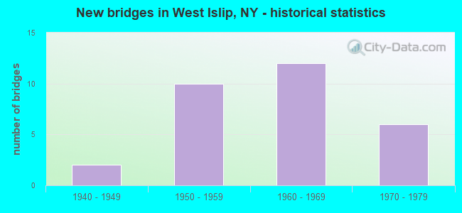
- New bridges - historical statistics
- 21940-1949
- 101950-1959
- 121960-1969
- 61970-1979
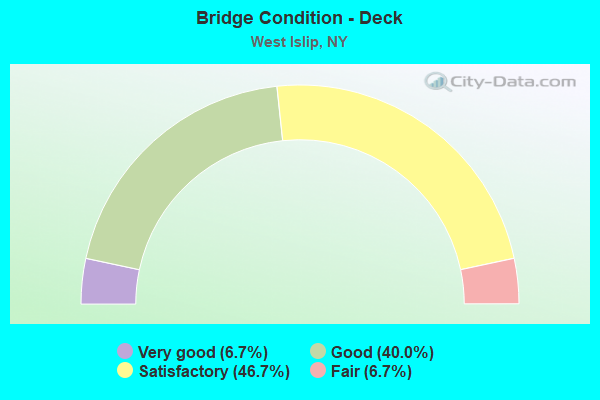
- Bridge Condition - Deck
- 6.7%Very good
- 40.0%Good
- 46.7%Satisfactory
- 6.7%Fair
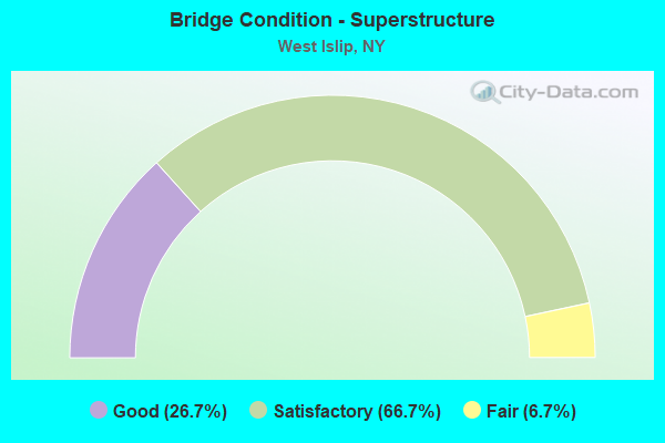
- Bridge Condition - Superstructure
- 26.7%Good
- 66.7%Satisfactory
- 6.7%Fair
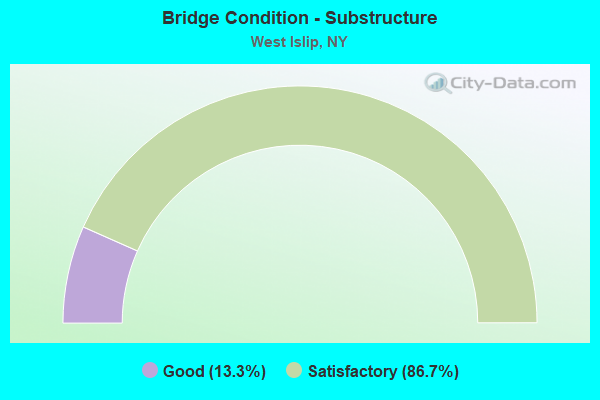
- Bridge Condition - Substructure
- 13.3%Good
- 86.7%Satisfactory
Find on map >> Show street view
Structure Number: 1056011, Location: .5 MI N JCT RTS 231+27A (Lat: 40.703889, Lng: -73.314081), Route carried "on" structure: State highway 231, Year Built: 1968, Status: Open, Structure Length: 16.25m (53.31ft), Average Daily Traffic: 12,796 (year 2019), Truck Traffic: 3%, Average Future Daily Traffic: 15,544 (year 2040), Design Load: HS 20, Features Intersected: JOHN STREET, JOHN STREET
Minimum Vertical Clearance: 30+ m (98+ ft), Kilometerpoint: 0.885, Lanes on structure: 2, Lanes under structure: 4, Base Highway Network: Yes, Owner: State Highway Agency, Approaching Roadway Width: 8.8m (28.9ft), Skew: 4 degrees, Material/Design: Steel, Design/Construction: Stringer/Multi-beam, Number Of Spans In Main Unit: 8, Length of Maximum Span: 23.8m (78.1ft), Curb-To-Curb Width: 8.8m (28.9ft), Out-to-Out Width: 10.1m (33.1ft)
Condition: Deck: Satisfactory, Superstructure: Satisfactory, Substructure: Satisfactory, Operating Rating: 45.7 metric tons, Method Used To Determine Operating Rating: Load and Resistance Factor Rating (LRFR) rating reported by rating factor(RF) method using HL-93 loadings, Inventory Rating: 35.3 metric tons, Method Used To Determine Inventory Rating: Load and Resistance Factor Rating (LRFR) rating reported by rating factor(RF) method using HL-93 loadings, Structural Evaluation: Equal to present minimum criteria, Deck Geometry: High priority of corrective action, Underclear: Meets minimum limits, Waterway Adequacy: Somewhat better than minimum adequacy, Approach Roadway Alignment: Equal to present desirable criteria, Length Of Structure Improvement: 16.24m (53.28ft), Designated Inspection Frequency: Every 24 months, Inspection Date: July 2020, Bridge Improvement Cost: $6,013,000, Roadway Improvement Cost: $3,521,000, Total Project Cost: $9,535,000 ( Estimate for 2021), Deck Structure Type: Concrete Cast-file-Place, Wearing Surface/Protective System: Wearing Surface: Monolithic Concrete
Find on map >> Show street view
Structure Number: 1056012, Location: .5 MI N JCT SH231 & SH27A (Lat: 40.704039, Lng: -73.313756), Route carried "on" structure: State highway 231, Year Built: 1968, Status: Open, Structure Length: 16.18m (53.08ft), Average Daily Traffic: 12,796 (year 2020), Truck Traffic: 5%, Average Future Daily Traffic: 15,544 (year 2040), Design Load: HS 20, Features Intersected: JOHN ST, JOHN ST_EB Road
Minimum Vertical Clearance: 30+ m (98+ ft), Kilometerpoint: 0.837, Lanes on structure: 3, Lanes under structure: 4, Base Highway Network: Yes, Owner: State Highway Agency, Approaching Roadway Width: 11.6m (38.1ft), Skew: 4 degrees, Material/Design: Steel, Design/Construction: Stringer/Multi-beam, Number Of Spans In Main Unit: 8, Length of Maximum Span: 23.1m (75.8ft), Curb-To-Curb Width: 11.7m (38.4ft), Out-to-Out Width: 13.2m (43.3ft)
Condition: Deck: Satisfactory, Superstructure: Satisfactory, Substructure: Satisfactory, Operating Rating: 42.4 metric tons, Method Used To Determine Operating Rating: Load and Resistance Factor Rating (LRFR) rating reported by rating factor(RF) method using HL-93 loadings, Inventory Rating: 32.7 metric tons, Method Used To Determine Inventory Rating: Load and Resistance Factor Rating (LRFR) rating reported by rating factor(RF) method using HL-93 loadings, Structural Evaluation: Equal to present minimum criteria, Deck Geometry: High priority of corrective action, Underclear: Meets minimum limits, Waterway Adequacy: Somewhat better than minimum adequacy, Approach Roadway Alignment: Equal to present desirable criteria, Length Of Structure Improvement: 16.18m (53.08ft), Designated Inspection Frequency: Every 24 months, Inspection Date: July 2020, Bridge Improvement Cost: $7,862,000, Roadway Improvement Cost: $4,604,000, Total Project Cost: $12,466,000 ( Estimate for 2021), Deck Structure Type: Concrete Cast-file-Place, Wearing Surface/Protective System: Wearing Surface: Monolithic Concrete
Find on map >> Show street view
Structure Number: 1057559, Location: 1.5 MI E JCT RTS 231+27 (Lat: 40.725869, Lng: -73.286889), Route carried "on" structure: State highway 908J, Year Built: 1969, Status: Open, Structure Length: 1.86m (6.10ft), Average Daily Traffic: 30,781 (year 2019), Truck Traffic: 1%, Average Future Daily Traffic: 36,613 (year 2040), Features Intersected: RTE 27
Minimum Vertical Clearance: 30+ m (98+ ft), Kilometerpoint: 12.325, Lanes on structure: 6, Lanes under structure: 3, Base Highway Network: Yes, Owner: State Highway Agency, Approaching Roadway Width: 25.0m (82.0ft), Skew: 23 degrees, Material/Design: Concrete, Design/Construction: Frame, Number Of Spans In Main Unit: 1, Length of Maximum Span: 17.4m (57.1ft), Curb-To-Curb Width: 25.0m (82.0ft), Out-to-Out Width: 28.3m (92.8ft)
Condition: Deck: Good, Superstructure: Satisfactory, Substructure: Satisfactory, Operating Rating: 84.9 metric tons, Method Used To Determine Operating Rating: Field evaluation and documented engineering judgment, Inventory Rating: 32.7 metric tons, Method Used To Determine Inventory Rating: Field evaluation and documented engineering judgment, Structural Evaluation: Equal to present minimum criteria, Deck Geometry: Meets minimum limits, Underclear: High priority of corrective action, Approach Roadway Alignment: Equal to present desirable criteria, Length Of Structure Improvement: 1.85m (6.07ft), Designated Inspection Frequency: Every 24 months, Inspection Date: November 2021, Bridge Improvement Cost: $4,072,000, Roadway Improvement Cost: $2,385,000, Total Project Cost: $6,457,000 ( Estimate for 2021)
Find on map >> Show street view
Structure Number: 105783, Location: 1.3 MI E JCT RTS 231+SSP (Lat: 40.733683, Lng: -73.296292), Route carried "on" structure: County highway , Year Built: 1960, Status: Open, Structure Length: 2.35m (7.71ft), Average Daily Traffic: 7,892 (year 2020), Truck Traffic: 8%, Average Future Daily Traffic: 9,587 (year 2040), Design Load: HS 20, Features Intersected: RTE 908M, Facility Carried by Structure: UDALL ROAD
Minimum Vertical Clearance: 30+ m (98+ ft), Kilometerpoint: 1.529, Lanes on structure: 2, Lanes under structure: 4, Owner: State Highway Agency, Approaching Roadway Width: 7.3m (24.0ft), Skew: 2 degrees, Material/Design: Concrete, Design/Construction: Frame, Number Of Spans In Main Unit: 1, Length of Maximum Span: 20.4m (66.9ft), Curb or Sidewalk Widths: Left: 2.1m (6.9ft), Right: 2.1m (6.9ft), Curb-To-Curb Width: 7.3m (24.0ft), Out-to-Out Width: 13.1m (43.0ft)
Condition: Deck: Good, Superstructure: Good, Substructure: Good, Operating Rating: 87.1 metric tons, Method Used To Determine Operating Rating: Field evaluation and documented engineering judgment, Inventory Rating: 32.7 metric tons, Method Used To Determine Inventory Rating: Field evaluation and documented engineering judgment, Structural Evaluation: Better than present minimum criteria, Deck Geometry: High priority of replacement, Underclear: High priority of corrective action, Approach Roadway Alignment: Equal to present desirable criteria, Length Of Structure Improvement: 2.34m (7.68ft), Designated Inspection Frequency: Every 24 months, Inspection Date: November 2021, Bridge Improvement Cost: $1,831,000, Roadway Improvement Cost: $1,072,000, Total Project Cost: $2,902,000 ( Estimate for 2021), Wearing Surface/Protective System: Wearing Surface: Bituminous, Membrane: Preformed Fabric
Find on map >> Show street view
Structure Number: 1057849, Location: 1.8 MI E JCT RTS 231+SSP (Lat: 40.735969, Lng: -73.287833), Route carried "on" structure: State highway 908J, Year Built: 1951, Status: Open, Structure Length: 2.65m (8.69ft), Average Daily Traffic: 46,535 (year 2019), Truck Traffic: 1%, Average Future Daily Traffic: 55,353 (year 2040), Design Load: H 20, Features Intersected: 908M 908M 0301 1134 WB S
Minimum Vertical Clearance: 30+ m (98+ ft), Kilometerpoint: 13.467, Lanes on structure: 3, Lanes under structure: 4, Owner: State Highway Agency, Approaching Roadway Width: 17.4m (57.1ft), Skew: 32 degrees, Material/Design: Concrete continuous, Design/Construction: Frame, Number Of Spans In Main Unit: 2, Length of Maximum Span: 11.8m (38.7ft), Curb-To-Curb Width: 17.3m (56.8ft), Out-to-Out Width: 21.3m (69.9ft)
Condition: Deck: Satisfactory, Superstructure: Satisfactory, Substructure: Satisfactory, Operating Rating: 60.5 metric tons, Method Used To Determine Operating Rating: Field evaluation and documented engineering judgment, Inventory Rating: 25.3 metric tons, Method Used To Determine Inventory Rating: Field evaluation and documented engineering judgment, Structural Evaluation: Equal to present minimum criteria, Deck Geometry: Better than present minimum criteria, Underclear: High priority of corrective action, Approach Roadway Alignment: Better than present minimum criteria, Length Of Structure Improvement: 2.65m (8.69ft), Designated Inspection Frequency: Every 24 months, Inspection Date: October 2021, Bridge Improvement Cost: $3,603,000, Roadway Improvement Cost: $2,110,000, Total Project Cost: $5,714,000 ( Estimate for 2021), Wearing Surface/Protective System: Wearing Surface: Bituminous, Membrane: Preformed Fabric
Find on map >> Show street view
Structure Number: 1057959, Location: 1.5 MI E JCT RTS 231+27 (Lat: 40.726561, Lng: -73.286792), Route carried "on" structure: State highway 908J, Year Built: 1969, Status: Open, Structure Length: 1.89m (6.20ft), Average Daily Traffic: 46,535 (year 2019), Truck Traffic: 1%, Average Future Daily Traffic: 55,353 (year 2040), Features Intersected: RTE 27
Minimum Vertical Clearance: 30+ m (98+ ft), Kilometerpoint: 12.389, Lanes on structure: 6, Lanes under structure: 3, Base Highway Network: Yes, Owner: State Highway Agency, Approaching Roadway Width: 25.0m (82.0ft), Skew: 23 degrees, Material/Design: Concrete, Design/Construction: Frame, Number Of Spans In Main Unit: 1, Length of Maximum Span: 17.6m (57.7ft), Curb-To-Curb Width: 25.0m (82.0ft), Out-to-Out Width: 28.3m (92.8ft)
Condition: Deck: Good, Superstructure: Good, Substructure: Satisfactory, Operating Rating: 85.2 metric tons, Method Used To Determine Operating Rating: Field evaluation and documented engineering judgment, Inventory Rating: 32.7 metric tons, Method Used To Determine Inventory Rating: Field evaluation and documented engineering judgment, Structural Evaluation: Equal to present minimum criteria, Deck Geometry: Meets minimum limits, Underclear: High priority of corrective action, Approach Roadway Alignment: Equal to present desirable criteria, Length Of Structure Improvement: 1.88m (6.17ft), Designated Inspection Frequency: Every 24 months, Inspection Date: November 2021, Bridge Improvement Cost: $4,526,000, Roadway Improvement Cost: $2,651,000, Total Project Cost: $7,177,000 ( Estimate for 2021)
Find on map >> Show street view
Structure Number: 1058839, Location: IN WEST ISLIP (Lat: 40.696633, Lng: -73.288394), Route carried "on" structure: State highway 908J, Year Built: 1952, Status: Open, Structure Length: 2.93m (9.61ft), Average Daily Traffic: 30,781 (year 2020), Truck Traffic: 2%, Average Future Daily Traffic: 36,613 (year 2040), Design Load: H 20, Features Intersected: RTE 27A
Minimum Vertical Clearance: 30+ m (98+ ft), Kilometerpoint: 9.043, Lanes on structure: 4, Lanes under structure: 5, Base Highway Network: Yes, Owner: State Highway Agency, Approaching Roadway Width: 17.1m (56.1ft), Skew: 21 degrees, Material/Design: Concrete, Design/Construction: Frame, Number Of Spans In Main Unit: 1, Length of Maximum Span: 27.1m (88.9ft), Curb-To-Curb Width: 17.1m (56.1ft), Out-to-Out Width: 21.6m (70.9ft)
Condition: Deck: Fair, Superstructure: Fair, Substructure: Satisfactory, Operating Rating: 67.0 metric tons, Method Used To Determine Operating Rating: Field evaluation and documented engineering judgment, Inventory Rating: 22.9 metric tons, Method Used To Determine Inventory Rating: Field evaluation and documented engineering judgment, Structural Evaluation: Somewhat better than minimum adequacy, Deck Geometry: High priority of corrective action, Underclear: High priority of corrective action, Approach Roadway Alignment: Equal to present desirable criteria, Length Of Structure Improvement: 2.92m (9.58ft), Designated Inspection Frequency: Every 24 months, Inspection Date: April 2020, Bridge Improvement Cost: $3,747,000, Roadway Improvement Cost: $2,194,000, Total Project Cost: $5,942,000 ( Estimate for 2021), Wearing Surface/Protective System: Wearing Surface: Bituminous, Membrane: Preformed Fabric
Find on map >> Show street view
Structure Number: 1058849, Location: .9 MILE S JCT SH 27 & RMC (Lat: 40.712319, Lng: -73.288656), Route carried "on" structure: State highway 908J, Year Built: 1952, Status: Open, Structure Length: 6.04m (19.82ft), Average Daily Traffic: 30,781 (year 2019), Truck Traffic: 1%, Average Future Daily Traffic: 36,613 (year 2040), Design Load: H 20, Features Intersected: UNION BLVD- CR 50, LONG
Minimum Vertical Clearance: 30+ m (98+ ft), Kilometerpoint: 10.796, Lanes on structure: 4, Lanes under structure: 4, Base Highway Network: Yes, Owner: State Highway Agency, Approaching Roadway Width: 19.2m (63.0ft), Skew: 32 degrees, Material/Design: Concrete continuous, Design/Construction: Frame, Number Of Spans In Main Unit: 3, Length of Maximum Span: 20.1m (65.9ft), Curb-To-Curb Width: 19.2m (63.0ft), Out-to-Out Width: 23.5m (77.1ft)
Condition: Deck: Satisfactory, Superstructure: Satisfactory, Substructure: Satisfactory, Operating Rating: 58.4 metric tons, Method Used To Determine Operating Rating: Field evaluation and documented engineering judgment, Inventory Rating: 23.0 metric tons, Method Used To Determine Inventory Rating: Field evaluation and documented engineering judgment, Structural Evaluation: Somewhat better than minimum adequacy, Deck Geometry: Somewhat better than minimum adequacy, Underclear: High priority of corrective action, Approach Roadway Alignment: Equal to present desirable criteria, Length Of Structure Improvement: 6.03m (19.78ft), Designated Inspection Frequency: Every 24 months, Inspection Date: August 2021, Bridge Improvement Cost: $7,807,000, Roadway Improvement Cost: $4,572,000, Total Project Cost: $12,379,000 ( Estimate for 2021), Wearing Surface/Protective System: Wearing Surface: Bituminous, Membrane: Preformed Fabric
Find on map >> Show street view
Structure Number: 1058859, Location: 1.5 MI E JCT RTS 231+27 (Lat: 40.726136, Lng: -73.286853), Route carried "on" structure: State highway 908J, Year Built: 1952, Status: Open, Structure Length: 4.60m (15.09ft), Average Daily Traffic: 46,535 (year 2019), Truck Traffic: 1%, Average Future Daily Traffic: 55,353 (year 2040), Design Load: H 20, Features Intersected: 27 27 07051081, RTE 27
Minimum Vertical Clearance: 30+ m (98+ ft), Kilometerpoint: 12.341, Lanes on structure: 6, Lanes under structure: 6, Base Highway Network: Yes, Owner: State Highway Agency, Approaching Roadway Width: 25.0m (82.0ft), Skew: 23 degrees, Material/Design: Concrete continuous, Design/Construction: Frame, Number Of Spans In Main Unit: 2, Length of Maximum Span: 21.0m (68.9ft), Curb-To-Curb Width: 25.0m (82.0ft), Out-to-Out Width: 28.3m (92.8ft)
Condition: Deck: Satisfactory, Superstructure: Satisfactory, Substructure: Satisfactory, Operating Rating: 59.8 metric tons, Method Used To Determine Operating Rating: Field evaluation and documented engineering judgment, Inventory Rating: 23.3 metric tons, Method Used To Determine Inventory Rating: Field evaluation and documented engineering judgment, Structural Evaluation: Somewhat better than minimum adequacy, Deck Geometry: Meets minimum limits, Underclear: High priority of corrective action, Approach Roadway Alignment: Equal to present desirable criteria, Length Of Structure Improvement: 4.60m (15.09ft), Designated Inspection Frequency: Every 24 months, Inspection Date: November 2021, Bridge Improvement Cost: $6,883,000, Roadway Improvement Cost: $4,031,000, Total Project Cost: $10,913,000 ( Estimate for 2021), Wearing Surface/Protective System: Wearing Surface: Bituminous, Membrane: Preformed Fabric
Find on map >> Show street view
Structure Number: 1058869, Location: 1.5 MI E JCT RTS 231+27 (Lat: 40.728225, Lng: -73.286553), Route carried "on" structure: State highway 908J, Year Built: 1952, Status: Open, Structure Length: 2.62m (8.60ft), Average Daily Traffic: 46,535 (year 2019), Truck Traffic: 1%, Average Future Daily Traffic: 55,353 (year 2040), Design Load: H 20, Features Intersected: MUNCEY ROAD
Minimum Vertical Clearance: 30+ m (98+ ft), Kilometerpoint: 12.582, Lanes on structure: 6, Lanes under structure: 2, Base Highway Network: Yes, Owner: State Highway Agency, Approaching Roadway Width: 25.3m (83.0ft), Skew: 33 degrees, Material/Design: Concrete, Design/Construction: Frame, Number Of Spans In Main Unit: 1, Length of Maximum Span: 21.9m (71.9ft), Curb-To-Curb Width: 25.3m (83.0ft), Out-to-Out Width: 29.3m (96.1ft)
Condition: Deck: Satisfactory, Superstructure: Satisfactory, Substructure: Good, Operating Rating: 61.0 metric tons, Method Used To Determine Operating Rating: Field evaluation and documented engineering judgment, Inventory Rating: 23.6 metric tons, Method Used To Determine Inventory Rating: Field evaluation and documented engineering judgment, Structural Evaluation: Somewhat better than minimum adequacy, Deck Geometry: Meets minimum limits, Underclear: Somewhat better than minimum adequacy, Approach Roadway Alignment: Equal to present desirable criteria, Length Of Structure Improvement: 2.62m (8.60ft), Designated Inspection Frequency: Every 24 months, Inspection Date: October 2021, Bridge Improvement Cost: $4,726,000, Roadway Improvement Cost: $2,767,000, Total Project Cost: $7,493,000 ( Estimate for 2021), Wearing Surface/Protective System: Wearing Surface: Bituminous, Membrane: Preformed Fabric
Find on map >> Show street view
Structure Number: 105983, Location: 1.3 MI E JCT RTS 231+SSP (Lat: 40.733472, Lng: -73.296347), Route carried "on" structure: County highway , Year Built: 1949, Status: Open, Structure Length: 2.41m (7.91ft), Average Daily Traffic: 7,892 (year 2020), Truck Traffic: 8%, Average Future Daily Traffic: 9,587 (year 2040), Design Load: H 20, Features Intersected: RTE 908M, Facility Carried by Structure: UDALL ROAD
Minimum Vertical Clearance: 30+ m (98+ ft), Kilometerpoint: 1.529, Lanes on structure: 2, Lanes under structure: 3, Owner: State Highway Agency, Approaching Roadway Width: 7.3m (24.0ft), Skew: 2 degrees, Material/Design: Concrete, Design/Construction: Frame, Number Of Spans In Main Unit: 1, Length of Maximum Span: 21.0m (68.9ft), Curb or Sidewalk Widths: Left: 2.1m (6.9ft), Right: 2.1m (6.9ft), Curb-To-Curb Width: 7.3m (24.0ft), Out-to-Out Width: 13.1m (43.0ft)
Condition: Deck: Good, Superstructure: Good, Substructure: Satisfactory, Operating Rating: 59.8 metric tons, Method Used To Determine Operating Rating: Field evaluation and documented engineering judgment, Inventory Rating: 23.3 metric tons, Method Used To Determine Inventory Rating: Field evaluation and documented engineering judgment, Structural Evaluation: Somewhat better than minimum adequacy, Deck Geometry: High priority of replacement, Underclear: High priority of corrective action, Approach Roadway Alignment: Equal to present desirable criteria, Length Of Structure Improvement: 2.40m (7.87ft), Designated Inspection Frequency: Every 24 months, Inspection Date: November 2021, Bridge Improvement Cost: $1,858,000, Roadway Improvement Cost: $1,088,000, Total Project Cost: $2,946,000 ( Estimate for 2021), Wearing Surface/Protective System: Wearing Surface: Bituminous, Membrane: Preformed Fabric
Find on map >> Show street view
Structure Number: 1059849, Location: 1.8 MI E JCT SH 231 & SSP (Lat: 40.735861, Lng: -73.287367), Route carried "on" structure: State highway 908J, Year Built: 1961, Status: Open, Structure Length: 2.13m (6.99ft), Average Daily Traffic: 46,535 (year 2019), Truck Traffic: 1%, Average Future Daily Traffic: 55,353 (year 2040), Design Load: HS 20, Features Intersected: RTE 908M
Minimum Vertical Clearance: 30+ m (98+ ft), Kilometerpoint: 13.451, Lanes on structure: 3, Lanes under structure: 4, Base Highway Network: Yes, Owner: State Highway Agency, Approaching Roadway Width: 17.4m (57.1ft), Skew: 21 degrees, Material/Design: Concrete, Design/Construction: Frame, Number Of Spans In Main Unit: 1, Length of Maximum Span: 18.8m (61.7ft), Curb-To-Curb Width: 17.4m (57.1ft), Out-to-Out Width: 21.7m (71.2ft)
Condition: Deck: Satisfactory, Superstructure: Satisfactory, Substructure: Satisfactory, Operating Rating: 86.0 metric tons, Method Used To Determine Operating Rating: Field evaluation and documented engineering judgment, Inventory Rating: 32.7 metric tons, Method Used To Determine Inventory Rating: Field evaluation and documented engineering judgment, Structural Evaluation: Equal to present minimum criteria, Deck Geometry: Better than present minimum criteria, Underclear: High priority of corrective action, Approach Roadway Alignment: Equal to present desirable criteria, Length Of Structure Improvement: 2.13m (6.99ft), Designated Inspection Frequency: Every 24 months, Inspection Date: April 2020, Bridge Improvement Cost: $3,018,000, Roadway Improvement Cost: $1,767,000, Total Project Cost: $4,786,000 ( Estimate for 2021), Wearing Surface/Protective System: Wearing Surface: Bituminous, Membrane: Preformed Fabric
Find on map >> Show street view
Structure Number: 106402, Location: .1 MI E JCT SH 231 & SH 2 (Lat: 40.718258, Lng: -73.311889), Route carried "on" structure: Other road , Year Built: 1972, Status: Open, Structure Length: 7.07m (23.20ft), Average Daily Traffic: 4,053 (year 2017), Truck Traffic: 2%, Average Future Daily Traffic: 5,674 (year 2037), Design Load: HS 20, Features Intersected: 27 27 07051066, 27 27, Facility Carried by Structure: HIGBIE LANE
Minimum Vertical Clearance: 30+ m (98+ ft), Kilometerpoint: 0.933, Lanes on structure: 2, Lanes under structure: 11, Owner: State Highway Agency, Approaching Roadway Width: 8.5m (27.9ft), Material/Design: Steel, Design/Construction: Stringer/Multi-beam, Number Of Spans In Main Unit: 4, Length of Maximum Span: 17.3m (56.8ft), Curb or Sidewalk Widths: Left: 1.4m (4.6ft), Right: 1.4m (4.6ft), Curb-To-Curb Width: 8.5m (27.9ft), Out-to-Out Width: 12.1m (39.7ft)
Condition: Deck: Good, Superstructure: Satisfactory, Substructure: Satisfactory, Operating Rating: 62.5 metric tons, Method Used To Determine Operating Rating: Load and Resistance Factor Rating (LRFR) rating reported by rating factor(RF) method using HL-93 loadings, Inventory Rating: 48.3 metric tons, Method Used To Determine Inventory Rating: Load and Resistance Factor Rating (LRFR) rating reported by rating factor(RF) method using HL-93 loadings, Structural Evaluation: Equal to present minimum criteria, Deck Geometry: Meets minimum limits, Underclear: High priority of corrective action, Approach Roadway Alignment: Equal to present minimum criteria, Length Of Structure Improvement: 7.07m (23.20ft), Designated Inspection Frequency: Every 24 months, Inspection Date: July 2020, Bridge Improvement Cost: $3,767,000, Roadway Improvement Cost: $2,206,000, Total Project Cost: $5,973,000 ( Estimate for 2021), Deck Structure Type: Concrete Cast-file-Place, Wearing Surface/Protective System: Wearing Surface: Monolithic Concrete
Find on map >> Show street view
Structure Number: 1064039, Location: .6 MI E JCT SH 231 & SH 2 (Lat: 40.720097, Lng: -73.302117), Route carried "on" structure: State highway 27, Year Built: 1972, Status: Open, Structure Length: 6.61m (21.69ft), Average Daily Traffic: 79,852 (year 2020), Truck Traffic: 7%, Average Future Daily Traffic: 94,983 (year 2040), Design Load: HS 20, Features Intersected: UDALL RD - CR 82 NB, UDA
Minimum Vertical Clearance: 30+ m (98+ ft), Kilometerpoint: 11.537, Lanes on structure: 6, Lanes under structure: 4, Base Highway Network: Yes, Owner: State Highway Agency, Approaching Roadway Width: 31.4m (103.0ft), Skew: 24 degrees, Material/Design: Steel, Design/Construction: Stringer/Multi-beam, Number Of Spans In Main Unit: 4, Length of Maximum Span: 21.0m (68.9ft), Curb or Sidewalk Widths: Left: 0.5m (1.6ft), Right: 0.2m (0.7ft), Curb-To-Curb Width: 31.3m (102.7ft), Out-to-Out Width: 33.4m (109.6ft)
Condition: Deck: Good, Superstructure: Satisfactory, Substructure: Satisfactory, Operating Rating: 54.4 metric tons, Method Used To Determine Operating Rating: Load Factor (LF), Inventory Rating: 32.7 metric tons, Method Used To Determine Inventory Rating: Load Factor (LF), Structural Evaluation: Equal to present minimum criteria, Deck Geometry: Superior to present desirable criteria, Underclear: Somewhat better than minimum adequacy, Approach Roadway Alignment: Equal to present desirable criteria, Length Of Structure Improvement: 6.61m (21.69ft), Designated Inspection Frequency: Every 24 months, Inspection Date: November 2020, Bridge Improvement Cost: $8,901,000, Roadway Improvement Cost: $5,212,000, Total Project Cost: $14,113,000 ( Estimate for 2021), Deck Structure Type: Concrete Cast-file-Place, Wearing Surface/Protective System: Wearing Surface: Monolithic Concrete
Find on map >> Show street view
Structure Number: 1064049, Location: 2 MI NE JCT SH 231 & SH 2 (Lat: 40.729122, Lng: -73.279844), Route carried "on" structure: State highway 27, Year Built: 1972, Status: Open, Structure Length: 4.21m (13.81ft), Average Daily Traffic: 90,050 (year 2020), Truck Traffic: 6%, Average Future Daily Traffic: 107,114 (year 2040), Design Load: HS 20, Features Intersected: MANOR LANE
Minimum Vertical Clearance: 30+ m (98+ ft), Kilometerpoint: 13.677, Lanes on structure: 8, Lanes under structure: 5, Base Highway Network: Yes, Owner: State Highway Agency, Approaching Roadway Width: 32.3m (106.0ft), Skew: 32 degrees, Material/Design: Steel, Design/Construction: Stringer/Multi-beam, Number Of Spans In Main Unit: 3, Length of Maximum Span: 23.4m (76.8ft), Curb or Sidewalk Widths: Left: 0.5m (1.6ft), Right: 0.5m (1.6ft), Curb-To-Curb Width: 32.3m (106.0ft), Out-to-Out Width: 35.1m (115.2ft)
Condition: Deck: Very good, Superstructure: Good, Substructure: Satisfactory, Operating Rating: 51.8 metric tons, Method Used To Determine Operating Rating: Load and Resistance Factor Rating (LRFR) rating reported by rating factor(RF) method using HL-93 loadings, Inventory Rating: 39.5 metric tons, Method Used To Determine Inventory Rating: Load and Resistance Factor Rating (LRFR) rating reported by rating factor(RF) method using HL-93 loadings, Structural Evaluation: Equal to present minimum criteria, Deck Geometry: Meets minimum limits, Underclear: Somewhat better than minimum adequacy, Approach Roadway Alignment: Equal to present desirable criteria, Length Of Structure Improvement: 4.20m (13.78ft), Designated Inspection Frequency: Every 24 months, Inspection Date: July 2020, Bridge Improvement Cost: $6,734,000, Roadway Improvement Cost: $3,943,000, Total Project Cost: $10,677,000 ( Estimate for 2021), Deck Structure Type: Concrete Cast-file-Place, Wearing Surface/Protective System: Wearing Surface: Monolithic Concrete
Find on map >> Show street view
Structure Number: 1056011, Location: .5 MI N JCT RTS 231+27A (Lat: 40.703889, Lng: -73.314081), Route carried "under" structure: County highway , Year Built: 1968, Structure Length: 0. m, Average Daily Traffic: 15,805 (year 2004), Features Intersected: JOHN STREET, JOHN STREET, Facility Carried by Structure: RTE 231
Minimum Vertical Clearance: 6.86m (22.51ft), Kilometerpoint: 0.000, Lanes on structure: 2, Lanes under structure: 2, Material/Design: Steel, Design/Construction: Stringer/Multi-beam, Length of Maximum Span: 23.8m (78.1ft)
Find on map >> Show street view
Structure Number: 1056012, Location: .5 MI N JCT SH231 & SH27A (Lat: 40.704039, Lng: -73.313756), Route carried "under" structure: County highway , Year Built: 1968, Structure Length: 0. m, Average Daily Traffic: 15,805 (year 2004), Features Intersected: JOHN ST, JOHN ST_EB Road, Facility Carried by Structure: RTE 231
Minimum Vertical Clearance: 7.82m (25.66ft), Kilometerpoint: 0.000, Lanes on structure: 3, Lanes under structure: 2, Material/Design: Steel, Design/Construction: Stringer/Multi-beam, Length of Maximum Span: 23.1m (75.8ft)
Find on map >> Show street view
Structure Number: 1057559, Location: 1.5 MI E JCT RTS 231+27 (Lat: 40.725869, Lng: -73.286889), Route carried "under" structure: ServiceState highway 27, Year Built: 1969, Structure Length: 0. m, Average Daily Traffic: 14,000 (year 2021), Features Intersected: RTE 27, Facility Carried by Structure: RTE 908J
Minimum Vertical Clearance: 5.23m (17.16ft), Kilometerpoint: 13.001, Lanes on structure: 6, Lanes under structure: 3, Material/Design: Concrete, Design/Construction: Frame, Length of Maximum Span: 17.4m (57.1ft)
Find on map >> Show street view
Structure Number: 105783, Location: 1.3 MI E JCT RTS 231+SSP (Lat: 40.733683, Lng: -73.296292), Route carried "under" structure: State highway 908M, Year Built: 1960, Structure Length: 0. m, Average Daily Traffic: 119,012 (year 2002), Features Intersected: RTE 908M, Facility Carried by Structure: UDALL ROAD
Minimum Vertical Clearance: 4.39m (14.40ft), Kilometerpoint: 11.907, Lanes on structure: 2, Lanes under structure: 4, Material/Design: Concrete, Design/Construction: Frame, Length of Maximum Span: 20.4m (66.9ft)
Find on map >> Show street view
Structure Number: 1057849, Location: 1.8 MI E JCT RTS 231+SSP (Lat: 40.735969, Lng: -73.287833), Route carried "under" structure: State highway 908M, Year Built: 1951, Structure Length: 0. m, Average Daily Traffic: 119,012 (year 2002), Features Intersected: 908M 908M 0301 1134 WB S, Facility Carried by Structure: RTE 908J
Minimum Vertical Clearance: 4.06m (13.32ft), Kilometerpoint: 12.711, Lanes on structure: 3, Lanes under structure: 2, Material/Design: Concrete continuous, Design/Construction: Frame, Length of Maximum Span: 11.8m (38.7ft)
Find on map >> Show street view
Structure Number: 1057959, Location: 1.5 MI E JCT RTS 231+27 (Lat: 40.726561, Lng: -73.286792), Route carried "under" structure: State highway 27, Year Built: 1969, Structure Length: 0. m, Average Daily Traffic: 14,000 (year 2021), Features Intersected: RTE 27, Facility Carried by Structure: RTE 908J
Minimum Vertical Clearance: 4.85m (15.91ft), Kilometerpoint: 13.001, Lanes on structure: 6, Lanes under structure: 3, Material/Design: Concrete, Design/Construction: Frame, Length of Maximum Span: 17.6m (57.7ft)
Find on map >> Show street view
Structure Number: 1058839, Location: IN WEST ISLIP (Lat: 40.696633, Lng: -73.288394), Route carried "under" structure: Alternate State highway 27A, Year Built: 1952, Structure Length: 0. m, Average Daily Traffic: 20,900 (year 1977), Features Intersected: RTE 27A, Facility Carried by Structure: RTE 908J
Minimum Vertical Clearance: 4.98m (16.34ft), Kilometerpoint: 12.389, Lanes on structure: 4, Lanes under structure: 5, Material/Design: Concrete, Design/Construction: Frame, Length of Maximum Span: 27.1m (88.9ft)
Find on map >> Show street view
Structure Number: 1058849, Location: .9 MILE S JCT SH 27 & RMC (Lat: 40.712319, Lng: -73.288656), Route carried "under" structure: County highway , Year Built: 1952, Structure Length: 0. m, Average Daily Traffic: 3,500 (year 2004), Features Intersected: UNION BLVD- CR 50, LONG, Facility Carried by Structure: RTE 908J
Minimum Vertical Clearance: 5.92m (19.42ft), Kilometerpoint: 0.000, Lanes on structure: 4, Lanes under structure: 2, Material/Design: Concrete continuous, Design/Construction: Frame, Length of Maximum Span: 20.1m (65.9ft)
Find on map >> Show street view
Structure Number: 1058859, Location: 1.5 MI E JCT RTS 231+27 (Lat: 40.726136, Lng: -73.286853), Route carried "under" structure: State highway 27, Year Built: 1952, Structure Length: 0. m, Average Daily Traffic: 26,400 (year 1972), Features Intersected: 27 27 07051081, RTE 27, Facility Carried by Structure: RTE 908J
Minimum Vertical Clearance: 5.44m (17.85ft), Kilometerpoint: 13.001, Lanes on structure: 6, Lanes under structure: 3, Material/Design: Concrete continuous, Design/Construction: Frame, Length of Maximum Span: 21.0m (68.9ft)
Find on map >> Show street view
Structure Number: 1058869, Location: 1.5 MI E JCT RTS 231+27 (Lat: 40.728225, Lng: -73.286553), Route carried "under" structure: Other road , Year Built: 1952, Structure Length: 0. m, Average Daily Traffic: 3,000 (year 2021), Features Intersected: MUNCEY ROAD, Facility Carried by Structure: RTE 908J
Minimum Vertical Clearance: 4.52m (14.83ft), Kilometerpoint: 0.000, Lanes on structure: 6, Lanes under structure: 2, Material/Design: Concrete, Design/Construction: Frame, Length of Maximum Span: 21.9m (71.9ft)
Find on map >> Show street view
Structure Number: 105983, Location: 1.3 MI E JCT RTS 231+SSP (Lat: 40.733472, Lng: -73.296347), Route carried "under" structure: State highway 908M, Year Built: 1949, Structure Length: 0. m, Average Daily Traffic: 119,012 (year 2002), Features Intersected: RTE 908M, Facility Carried by Structure: UDALL ROAD
Minimum Vertical Clearance: 4.42m (14.50ft), Kilometerpoint: 11.907, Lanes on structure: 2, Lanes under structure: 3, Material/Design: Concrete, Design/Construction: Frame, Length of Maximum Span: 21.0m (68.9ft)
Find on map >> Show street view
Structure Number: 1059849, Location: 1.8 MI E JCT SH 231 & SSP (Lat: 40.735861, Lng: -73.287367), Route carried "under" structure: State highway 908M, Year Built: 1961, Structure Length: 0. m, Average Daily Traffic: 119,012 (year 2002), Features Intersected: RTE 908M, Facility Carried by Structure: RTE 908J
Minimum Vertical Clearance: 4.24m (13.91ft), Kilometerpoint: 12.711, Lanes on structure: 3, Lanes under structure: 4, Material/Design: Concrete, Design/Construction: Frame, Length of Maximum Span: 18.8m (61.7ft)
Find on map >> Show street view
Structure Number: 106402, Location: .1 MI E JCT SH 231 & SH 2 (Lat: 40.718258, Lng: -73.311889), Route carried "under" structure: State highway 27, Year Built: 1972, Structure Length: 0. m, Average Daily Traffic: 38,500 (year 1976), Features Intersected: 27 27 07051066, 27 27, Facility Carried by Structure: HIGBIE LANE
Minimum Vertical Clearance: 4.62m (15.16ft), Kilometerpoint: 10.603, Lanes on structure: 2, Lanes under structure: 3, Material/Design: Steel, Design/Construction: Stringer/Multi-beam, Length of Maximum Span: 17.3m (56.8ft)
Find on map >> Show street view
Structure Number: 1064039, Location: .6 MI E JCT SH 231 & SH 2 (Lat: 40.720097, Lng: -73.302117), Route carried "under" structure: Other road , Year Built: 1972, Structure Length: 0. m, Average Daily Traffic: 20,665 (year 2004), Features Intersected: UDALL RD - CR 82 NB, UDA, Facility Carried by Structure: RTE 27
Minimum Vertical Clearance: 4.42m (14.50ft), Kilometerpoint: 0.000, Lanes on structure: 6, Lanes under structure: 2, Material/Design: Steel, Design/Construction: Stringer/Multi-beam, Length of Maximum Span: 21.0m (68.9ft)
Find on map >> Show street view
Structure Number: 1064049, Location: 2 MI NE JCT SH 231 & SH 2 (Lat: 40.729122, Lng: -73.279844), Route carried "under" structure: Other road , Year Built: 1972, Structure Length: 0. m, Average Daily Traffic: 16,000 (year 2021), Features Intersected: MANOR LANE, Facility Carried by Structure: RTE 27
Minimum Vertical Clearance: 4.70m (15.42ft), Kilometerpoint: 0.000, Lanes on structure: 8, Lanes under structure: 5, Material/Design: Steel, Design/Construction: Stringer/Multi-beam, Length of Maximum Span: 23.4m (76.8ft)