Bridge Statistics for West Fargo, North Dakota (ND)
Condition, Traffic, Stress, Structural Evaluation, Project Costs
- National Bridge Inventory (NBI) Statistics
- 41Number of bridges
- 410ft / 125mTotal length
- $919,000Total costs
- 257,180Total average daily traffic
- 23,594Total average daily truck traffic
- National Bridge Inventory (NBI) Registered Bridges for West Fargo
- No street view available for this location
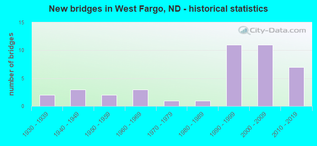
- New bridges - historical statistics
- 21930-1939
- 31940-1949
- 21950-1959
- 31960-1969
- 11970-1979
- 11980-1989
- 111990-1999
- 112000-2009
- 72010-2019

- Reconstructed bridges - Historical Statistics
- 11940-1949
- 11950-1959
- 01960-1969
- 11970-1979
- 01980-1989
- 11990-1999
- 02000-2009
- 22010-2019


- Bridge Condition - Deck
- 12.5%Very good
- 43.8%Good
- 31.3%Satisfactory
- 6.3%Fair
- 6.3%Poor

- Bridge Condition - Superstructure
- 12.5%Very good
- 37.5%Good
- 6.3%Satisfactory
- 37.5%Fair
- 6.3%Poor

- Bridge Condition - Substructure
- 31.3%Very good
- 25.0%Good
- 18.8%Satisfactory
- 25.0%Fair

- Bridge Condition - Channel
- 20.0%Very good
- 48.0%Good
- 28.0%Satisfactory
- 4.0%Fair

- Bridge Condition - Culverts
- 35.7%Very good
- 28.6%Good
- 35.7%Satisfactory
Find on map >> Show street view
Structure Number: 913524, Location: 4 EAST OF MAPLETON (Lat: 46.891558, Lng: -96.972253), Route carried "on" structure: County highway 930, Year Built: 1947, Year Reconstructed: 1954, Status: Open, Structure Length: 1.34m (4.40ft), Average Daily Traffic: 575 (year 2019), Truck Traffic: 12%, Average Future Daily Traffic: 500 (year 2039), Features Intersected: DRAIN 14, Facility Carried by Structure: COUNTY HIGHWAY
Minimum Vertical Clearance: 30+ m (98+ ft), Kilometerpoint: 57.280, Lanes on structure: 2, Owner: County Highway Agency, Approaching Roadway Width: 12.2m (40.0ft), Material/Design: Concrete, Design/Construction: Tee Beam, Number Of Spans In Main Unit: 1, Length of Maximum Span: 12.8m (42.0ft), Curb or Sidewalk Widths: Left: 0.2m (0.7ft), Right: 0.2m (0.7ft), Curb-To-Curb Width: 8.6m (28.2ft), Out-to-Out Width: 9.2m (30.2ft)
Condition: Deck: Satisfactory, Superstructure: Fair, Substructure: Fair, Channel: Satisfactory, Operating Rating: 52.6 metric tons, Method Used To Determine Operating Rating: Load Factor (LF), Inventory Rating: 31.5 metric tons, Method Used To Determine Inventory Rating: Load Factor (LF), Structural Evaluation: Somewhat better than minimum adequacy, Deck Geometry: Somewhat better than minimum adequacy, Waterway Adequacy: Better than present minimum criteria, Approach Roadway Alignment: Equal to present desirable criteria, Length Of Structure Improvement: 1.34m (4.40ft), Designated Inspection Frequency: Every 24 months, Inspection Date: June 2021, Bridge Improvement Cost: $33,000, Roadway Improvement Cost: $3,000, Total Project Cost: $50,000, Deck Structure Type: Concrete Cast-file-Place, Wearing Surface/Protective System: Wearing Surface: Bituminous
Find on map >> Show street view
Structure Number: 913622, Location: 5 EAST 2 NORTH MAPLETON (Lat: 46.927672, Lng: -96.946311), Route carried "on" structure: County highway , Year Built: 1943, Year Reconstructed: 2010, Status: Posted for load, Structure Length: 3.29m (10.79ft), Average Daily Traffic: 20 (year 2020), Average Future Daily Traffic: 20 (year 2040), Features Intersected: MAPLE RIVER, Facility Carried by Structure: COUNTY HIGHWAY
Minimum Vertical Clearance: 30+ m (98+ ft), Kilometerpoint: 0.000, Lanes on structure: 2, Owner: County Highway Agency, Approaching Roadway Width: 4.9m (16.1ft), Material/Design: Wood or Timber, Design/Construction: Stringer/Multi-beam, Number Of Spans In Main Unit: 3, Length of Maximum Span: 11.6m (38.1ft), Curb or Sidewalk Widths: Left: 0.1m (0.3ft), Right: 0.1m (0.3ft), Curb-To-Curb Width: 7.0m (23.0ft), Out-to-Out Width: 7.3m (24.0ft)
Condition: Deck: Satisfactory, Superstructure: Fair, Substructure: Fair, Channel: Satisfactory, Operating Rating: 21.2 metric tons, Method Used To Determine Operating Rating: Allowable Stress (AS), Inventory Rating: 14.9 metric tons, Method Used To Determine Inventory Rating: Allowable Stress (AS), Structural Evaluation: Meets minimum limits, Deck Geometry: Somewhat better than minimum adequacy, Waterway Adequacy: Equal to present minimum criteria, Approach Roadway Alignment: Better than present minimum criteria, Bridge Posting: Required (Relationship of Operating Rating to Maximum Legal Load: > 39.9% below), Length Of Structure Improvement: 4.11m (13.48ft), Designated Inspection Frequency: Every 24 months, Inspection Date: June 2021, Bridge Improvement Cost: $175,000, Roadway Improvement Cost: $18,000, Total Project Cost: $263,000, Deck Structure Type: Wood or Timber, Wearing Surface/Protective System: Wearing Surface: Wood or Timber
Find on map >> Show street view
Structure Number: 9136231, Location: 4 EAST 1 NORTH MAPLETON (Lat: 46.905728, Lng: -96.965764), Route carried "on" structure: County highway , Year Built: 1952, Status: Open, Structure Length: 2.23m (7.32ft), Average Daily Traffic: 10 (year 2019), Average Future Daily Traffic: 20 (year 2039), Features Intersected: COUNTY DRAIN 14, Facility Carried by Structure: COUNTY HIGHWAY
Minimum Vertical Clearance: 30+ m (98+ ft), Kilometerpoint: 0.000, Lanes on structure: 2, Owner: County Highway Agency, Approaching Roadway Width: 4.3m (14.1ft), Material/Design: Concrete, Design/Construction: Channel Beam, Number Of Spans In Main Unit: 2, Length of Maximum Span: 10.7m (35.1ft), Curb or Sidewalk Widths: Left: 0.2m (0.7ft), Right: 0.2m (0.7ft), Curb-To-Curb Width: 7.3m (24.0ft), Out-to-Out Width: 7.8m (25.6ft)
Condition: Deck: Good, Superstructure: Good, Substructure: Satisfactory, Channel: Good, Operating Rating: 46.5 metric tons, Method Used To Determine Operating Rating: Load Factor (LF), Inventory Rating: 27.9 metric tons, Method Used To Determine Inventory Rating: Load Factor (LF), Structural Evaluation: Equal to present minimum criteria, Deck Geometry: Equal to present minimum criteria, Waterway Adequacy: Better than present minimum criteria, Approach Roadway Alignment: Meets minimum limits, Designated Inspection Frequency: Every 24 months, Inspection Date: June 2021, Deck Structure Type: Concrete Cast-file-Place
Find on map >> Show street view
Structure Number: 913821, Location: 2 WEST 3 SOUTH OF HARWOOD (Lat: 46.935556, Lng: -96.920408), Route carried "on" structure: County highway 928, Year Built: 1957, Year Reconstructed: 1977, Status: Open, Structure Length: 9.11m (29.89ft), Average Daily Traffic: 180 (year 2019), Truck Traffic: 12%, Average Future Daily Traffic: 430 (year 2039), Features Intersected: SHEYENNE RIVER, Facility Carried by Structure: COUNTY HIGHWAY
Minimum Vertical Clearance: 30+ m (98+ ft), Kilometerpoint: 9.976, Lanes on structure: 2, Owner: County Highway Agency, Approaching Roadway Width: 7.3m (24.0ft), Material/Design: Steel, Design/Construction: Stringer/Multi-beam, Number Of Spans In Main Unit: 4, Length of Maximum Span: 22.9m (75.1ft), Curb or Sidewalk Widths: Left: 0.3m (1.0ft), Right: 0.3m (1.0ft), Curb-To-Curb Width: 7.5m (24.6ft), Out-to-Out Width: 8.1m (26.6ft)
Condition: Deck: Satisfactory, Superstructure: Satisfactory, Substructure: Satisfactory, Channel: Satisfactory, Operating Rating: 60.4 metric tons, Method Used To Determine Operating Rating: Load Factor (LF), Inventory Rating: 28.4 metric tons, Method Used To Determine Inventory Rating: Load Factor (LF), Structural Evaluation: Equal to present minimum criteria, Deck Geometry: Somewhat better than minimum adequacy, Waterway Adequacy: Equal to present desirable criteria, Approach Roadway Alignment: Better than present minimum criteria, Designated Inspection Frequency: Every 24 months, Inspection Date: September 2021, Deck Structure Type: Concrete Cast-file-Place, Wearing Surface/Protective System: Wearing Surface: Monolithic Concrete
Find on map >> Show street view
Structure Number: 9138231, Location: 1 NORTH 1 WEST RIVERSIDE (Lat: 46.905514, Lng: -96.909011), Route carried "on" structure: County highway , Year Built: 1980, Status: Open, Structure Length: 4.60m (15.09ft), Average Daily Traffic: 75 (year 2019), Average Future Daily Traffic: 75 (year 2039), Design Load: H 20, Features Intersected: SHEYENNE RIVER, Facility Carried by Structure: COUNTY HIGHWAY
Minimum Vertical Clearance: 30+ m (98+ ft), Kilometerpoint: 0.000, Lanes on structure: 2, Owner: County Highway Agency, Approaching Roadway Width: 6.1m (20.0ft), Material/Design: Prestressed concrete, Design/Construction: Tee Beam, Number Of Spans In Main Unit: 3, Length of Maximum Span: 14.9m (48.9ft), Curb-To-Curb Width: 7.9m (25.9ft), Out-to-Out Width: 8.5m (27.9ft)
Condition: Deck: Fair, Superstructure: Fair, Substructure: Fair, Channel: Fair, Operating Rating: 73.1 metric tons, Method Used To Determine Operating Rating: Load Factor (LF), Inventory Rating: 41.4 metric tons, Method Used To Determine Inventory Rating: Load Factor (LF), Structural Evaluation: Somewhat better than minimum adequacy, Deck Geometry: Equal to present minimum criteria, Waterway Adequacy: Equal to present desirable criteria, Approach Roadway Alignment: Equal to present desirable criteria, Length Of Structure Improvement: 4.60m (15.09ft), Designated Inspection Frequency: Every 24 months, Inspection Date: June 2021, Bridge Improvement Cost: $106,000, Roadway Improvement Cost: $11,000, Total Project Cost: $159,000, Deck Structure Type: Concrete Precast Panels
Find on map >> Show street view
Structure Number: 913827, Location: 2 SOUTH 1 WEST WEST FARGO (Lat: 46.848097, Lng: -96.923547), Route carried "on" structure: County highway , Year Built: 1991, Status: Open, Structure Length: 1.25m (4.10ft), Average Daily Traffic: 60 (year 2017), Average Future Daily Traffic: 60 (year 2037), Design Load: HS 20, Features Intersected: SHEYENNE DIVERSION, Facility Carried by Structure: COUNTY HIGHWAY
Minimum Vertical Clearance: 30+ m (98+ ft), Kilometerpoint: 0.000, Lanes on structure: 2, Owner: County Highway Agency, Approaching Roadway Width: 6.1m (20.0ft), Material/Design: Concrete, Design/Construction: Culvert, Number Of Spans In Main Unit: 3, Length of Maximum Span: 4.0m (13.1ft)
Condition: Channel: Good, Culverts: Satisfactory, Operating Rating: 54.0 metric tons, Method Used To Determine Operating Rating: Load Factor (LF), Inventory Rating: 32.4 metric tons, Method Used To Determine Inventory Rating: Load Factor (LF), Structural Evaluation: Equal to present minimum criteria, Waterway Adequacy: Superior to present desirable criteria, Approach Roadway Alignment: Equal to present desirable criteria, Designated Inspection Frequency: Every 48 months, Inspection Date: June 2021
Find on map >> Show street view
Structure Number: 9138281, Location: 3 SOUTH 1 WEST WEST FARGO (Lat: 46.833583, Lng: -96.925833), Route carried "on" structure: County highway , Year Built: 1991, Status: Open, Structure Length: 1.22m (4.00ft), Average Daily Traffic: 170 (year 2017), Truck Traffic: 15%, Average Future Daily Traffic: 170 (year 2037), Design Load: HS 25 or greater, Features Intersected: SHEYENNE DIVERSION, Facility Carried by Structure: COUNTY HIGHWAY
Minimum Vertical Clearance: 30+ m (98+ ft), Kilometerpoint: 0.000, Lanes on structure: 2, Owner: County Highway Agency, Approaching Roadway Width: 7.9m (25.9ft), Material/Design: Concrete, Design/Construction: Culvert, Number Of Spans In Main Unit: 3, Length of Maximum Span: 3.7m (12.1ft)
Condition: Channel: Good, Culverts: Satisfactory, Operating Rating: 67.5 metric tons, Method Used To Determine Operating Rating: Load Factor (LF), Inventory Rating: 40.5 metric tons, Method Used To Determine Inventory Rating: Load Factor (LF), Structural Evaluation: Equal to present minimum criteria, Waterway Adequacy: Superior to present desirable criteria, Approach Roadway Alignment: Better than present minimum criteria, Designated Inspection Frequency: Every 48 months, Inspection Date: June 2021
Find on map >> Show street view
Structure Number: 913829, Location: 4 SOUTH 1 WEST WEST FARGO (Lat: 46.818975, Lng: -96.923917), Route carried "on" structure: County highway , Year Built: 1991, Status: Open, Structure Length: 1.22m (4.00ft), Average Daily Traffic: 170 (year 2017), Truck Traffic: 15%, Average Future Daily Traffic: 170 (year 2037), Design Load: HS 25 or greater, Features Intersected: SHEYENNE DIVERSION, Facility Carried by Structure: COUNTY HIGHWAY
Minimum Vertical Clearance: 30+ m (98+ ft), Kilometerpoint: 0.000, Lanes on structure: 2, Owner: County Highway Agency, Approaching Roadway Width: 9.1m (29.9ft), Skew: 1 degrees, Material/Design: Concrete, Design/Construction: Culvert, Number Of Spans In Main Unit: 3, Length of Maximum Span: 3.7m (12.1ft)
Condition: Channel: Good, Culverts: Satisfactory, Operating Rating: 67.5 metric tons, Method Used To Determine Operating Rating: Load Factor (LF), Inventory Rating: 40.5 metric tons, Method Used To Determine Inventory Rating: Load Factor (LF), Structural Evaluation: Equal to present minimum criteria, Waterway Adequacy: Superior to present desirable criteria, Approach Roadway Alignment: Better than present minimum criteria, Designated Inspection Frequency: Every 48 months, Inspection Date: June 2021
Find on map >> Show street view
Structure Number: 91383, Location: 5 SOUTH 1 WEST WEST FARGO (Lat: 46.804522, Lng: -96.925542), Route carried "on" structure: County highway , Year Built: 1991, Status: Open, Structure Length: 1.22m (4.00ft), Average Daily Traffic: 170 (year 2017), Truck Traffic: 15%, Average Future Daily Traffic: 170 (year 2037), Design Load: HS 25 or greater, Features Intersected: SHEYENNE DIVERSION, Facility Carried by Structure: COUNTY HIGHWAY
Minimum Vertical Clearance: 30+ m (98+ ft), Kilometerpoint: 0.000, Lanes on structure: 2, Owner: County Highway Agency, Approaching Roadway Width: 6.7m (22.0ft), Material/Design: Concrete, Design/Construction: Culvert, Number Of Spans In Main Unit: 3, Length of Maximum Span: 3.7m (12.1ft)
Condition: Channel: Satisfactory, Culverts: Good, Operating Rating: 67.5 metric tons, Method Used To Determine Operating Rating: Load Factor (LF), Inventory Rating: 40.5 metric tons, Method Used To Determine Inventory Rating: Load Factor (LF), Structural Evaluation: Better than present minimum criteria, Waterway Adequacy: Superior to present desirable criteria, Approach Roadway Alignment: Better than present minimum criteria, Designated Inspection Frequency: Every 48 months, Inspection Date: June 2021
Find on map >> Show street view
Structure Number: 91393, Location: 4 SOUTH OF WEST FARGO (Lat: 46.804119, Lng: -96.901669), Route carried "on" structure: County highway 944, Year Built: 1971, Status: Open, Structure Length: 3.32m (10.89ft), Average Daily Traffic: 1,750 (year 2019), Truck Traffic: 6%, Average Future Daily Traffic: 1,500 (year 2039), Features Intersected: SHEYENNE RIVER, Facility Carried by Structure: COUNTY HIGHWAY
Minimum Vertical Clearance: 30+ m (98+ ft), Kilometerpoint: 65.808, Lanes on structure: 2, Owner: County Highway Agency, Approaching Roadway Width: 9.4m (30.8ft), Material/Design: Prestressed concrete, Design/Construction: Box Beam or Girders - Multiple, Number Of Spans In Main Unit: 3, Length of Maximum Span: 10.7m (35.1ft), Curb-To-Curb Width: 9.4m (30.8ft), Out-to-Out Width: 10.1m (33.1ft)
Condition: Deck: Poor, Superstructure: Poor, Substructure: Fair, Channel: Satisfactory, Operating Rating: 89.8 metric tons, Method Used To Determine Operating Rating: Load Factor (LF), Inventory Rating: 51.5 metric tons, Method Used To Determine Inventory Rating: Load Factor (LF), Structural Evaluation: Meets minimum limits, Deck Geometry: Somewhat better than minimum adequacy, Waterway Adequacy: Equal to present desirable criteria, Approach Roadway Alignment: Equal to present desirable criteria, Designated Inspection Frequency: Every 24 months, Inspection Date: June 2021, Bridge Improvement Cost: $90,000, Roadway Improvement Cost: $9,000, Total Project Cost: $135,000, Deck Structure Type: Concrete Precast Panels, Wearing Surface/Protective System: Wearing Surface: Bituminous
Find on map >> Show street view
Structure Number: WF01, Location: 19TH AVE NW - WEST FARGO (Lat: 46.906667, Lng: -96.868333), Route carried "on" structure: City street , Year Built: 2000, Status: Open, Structure Length: 1.43m (4.69ft), Average Daily Traffic: 500 (year 2017), Truck Traffic: 5%, Average Future Daily Traffic: 500 (year 2037), Design Load: HS 25 or greater, Features Intersected: CASS COUNTY DRAIN 21, Facility Carried by Structure: 19TH AVE NW
Minimum Vertical Clearance: 30+ m (98+ ft), Kilometerpoint: 0.000, Lanes on structure: 2, Owner: City or Municipal Highway Agency, Approaching Roadway Width: 6.1m (20.0ft), Material/Design: Concrete, Design/Construction: Culvert, Number Of Spans In Main Unit: 3, Length of Maximum Span: 4.3m (14.1ft)
Condition: Channel: Good, Culverts: Good, Operating Rating: 67.5 metric tons, Method Used To Determine Operating Rating: Load Factor (LF), Inventory Rating: 40.5 metric tons, Method Used To Determine Inventory Rating: Load Factor (LF), Structural Evaluation: Better than present minimum criteria, Waterway Adequacy: Equal to present desirable criteria, Approach Roadway Alignment: Equal to present desirable criteria, Designated Inspection Frequency: Every 48 months, Inspection Date: June 2021
Find on map >> Show street view
Structure Number: WF09, Location: 13TH AVE WEST WEST FARGO (Lat: 46.861667, Lng: -96.906667), Route carried "on" structure: City street 9233, Year Built: 2005, Status: Open, Structure Length: 0.64m (2.10ft), Average Daily Traffic: 4,900 (year 2017), Truck Traffic: 1%, Average Future Daily Traffic: 11,000 (year 2037), Design Load: HS 25 or greater, Features Intersected: SHEYENNE RIVER, Facility Carried by Structure: 13TH AVE.WEST
Minimum Vertical Clearance: 30+ m (98+ ft), Kilometerpoint: 1.448, Lanes on structure: 2, Owner: City or Municipal Highway Agency, Approaching Roadway Width: 12.2m (40.0ft), Skew: 10 degrees, Material/Design: Concrete, Design/Construction: Culvert, Number Of Spans In Main Unit: 2, Length of Maximum Span: 3.0m (9.8ft), Curb or Sidewalk Widths: Left: 0.3m (1.0ft), Right: 0.3m (1.0ft)
Condition: Channel: Good, Culverts: Very good, Operating Rating: 67.5 metric tons, Method Used To Determine Operating Rating: Load Factor (LF), Inventory Rating: 40.5 metric tons, Method Used To Determine Inventory Rating: Load Factor (LF), Structural Evaluation: Equal to present desirable criteria, Waterway Adequacy: Superior to present desirable criteria, Approach Roadway Alignment: Equal to present desirable criteria, Designated Inspection Frequency: Every 48 months, Inspection Date: June 2021
Find on map >> Show street view
Structure Number: WF11, Location: 7TH AVE WEST-WEST FARGO (Lat: 46.868333, Lng: -96.905000), Route carried "on" structure: City street 9229, Year Built: 1995, Status: Open, Structure Length: 0.67m (2.20ft), Average Daily Traffic: 3,050 (year 2017), Truck Traffic: 1%, Average Future Daily Traffic: 3,300 (year 2037), Design Load: HS 25 or greater, Features Intersected: SHEYENNE RIVER, Facility Carried by Structure: 7TH AVE WEST
Minimum Vertical Clearance: 30+ m (98+ ft), Kilometerpoint: 0.563, Lanes on structure: 2, Owner: City or Municipal Highway Agency, Approaching Roadway Width: 11.0m (36.1ft), Material/Design: Concrete, Design/Construction: Culvert, Number Of Spans In Main Unit: 3, Length of Maximum Span: 3.0m (9.8ft), Curb or Sidewalk Widths: Left: 1.2m (3.9ft), Right: 1.2m (3.9ft)
Condition: Channel: Good, Culverts: Good, Operating Rating: 67.5 metric tons, Method Used To Determine Operating Rating: Load Factor (LF), Inventory Rating: 40.5 metric tons, Method Used To Determine Inventory Rating: Load Factor (LF), Structural Evaluation: Better than present minimum criteria, Waterway Adequacy: Superior to present desirable criteria, Approach Roadway Alignment: Equal to present desirable criteria, Designated Inspection Frequency: Every 48 months, Inspection Date: June 2021
Find on map >> Show street view
Structure Number: WF12, Location: CITY OF WEST FARGO (Lat: 46.891667, Lng: -96.906667), Route carried "on" structure: City street , Year Built: 2003, Status: Open, Structure Length: 0.85m (2.79ft), Average Daily Traffic: 3,800 (year 2017), Truck Traffic: 1%, Average Future Daily Traffic: 4,185 (year 2037), Design Load: HS 25 or greater, Features Intersected: SHEYENNE RIVER, Facility Carried by Structure: 12TH AVE NW-WF
Minimum Vertical Clearance: 30+ m (98+ ft), Kilometerpoint: 0.000, Lanes on structure: 2, Owner: City or Municipal Highway Agency, Approaching Roadway Width: 12.2m (40.0ft), Skew: 3 degrees, Material/Design: Concrete, Design/Construction: Culvert, Number Of Spans In Main Unit: 2, Length of Maximum Span: 4.3m (14.1ft)
Condition: Channel: Good, Culverts: Very good, Operating Rating: 67.5 metric tons, Method Used To Determine Operating Rating: Load Factor (LF), Inventory Rating: 40.5 metric tons, Method Used To Determine Inventory Rating: Load Factor (LF), Structural Evaluation: Equal to present desirable criteria, Waterway Adequacy: Equal to present desirable criteria, Approach Roadway Alignment: Better than present minimum criteria, Designated Inspection Frequency: Every 48 months, Inspection Date: June 2021
Find on map >> Show street view
Structure Number: WF17, Location: SHEYENNE STREET-W FARGO (Lat: 46.853333, Lng: -96.903333), Route carried "on" structure: City street 9232, Year Built: 1993, Status: Open, Structure Length: 0.82m (2.69ft), Average Daily Traffic: 5,000 (year 2017), Truck Traffic: 2%, Average Future Daily Traffic: 5,500 (year 2037), Design Load: HS 25 or greater, Features Intersected: SHEYENNE RIVER, Facility Carried by Structure: SHEYENNE STREET
Minimum Vertical Clearance: 30+ m (98+ ft), Kilometerpoint: 2.446, Lanes on structure: 2, Owner: City or Municipal Highway Agency, Approaching Roadway Width: 12.2m (40.0ft), Skew: 3 degrees, Material/Design: Concrete, Design/Construction: Culvert, Number Of Spans In Main Unit: 2, Length of Maximum Span: 3.0m (9.8ft), Curb or Sidewalk Widths: Left: 1.4m (4.6ft), Right: 2.6m (8.5ft)
Condition: Channel: Good, Culverts: Good, Operating Rating: 67.5 metric tons, Method Used To Determine Operating Rating: Load Factor (LF), Inventory Rating: 40.5 metric tons, Method Used To Determine Inventory Rating: Load Factor (LF), Structural Evaluation: Better than present minimum criteria, Waterway Adequacy: Superior to present desirable criteria, Approach Roadway Alignment: Equal to present desirable criteria, Designated Inspection Frequency: Every 48 months, Inspection Date: June 2021
Find on map >> Show street view
Structure Number: WF2, Location: CITY OF WEST FARGO (Lat: 46.891436, Lng: -96.917936), Route carried "on" structure: City street 9221, Year Built: 1991, Status: Open, Structure Length: 7.65m (25.10ft), Average Daily Traffic: 2,000 (year 2019), Truck Traffic: 6%, Average Future Daily Traffic: 2,300 (year 2039), Design Load: HS 20, Features Intersected: SHEYENNE DIVERSION, Facility Carried by Structure: 12TH AVE NW-WF
Minimum Vertical Clearance: 30+ m (98+ ft), Kilometerpoint: 1.448, Lanes on structure: 2, Owner: City or Municipal Highway Agency, Approaching Roadway Width: 13.4m (44.0ft), Material/Design: Prestressed concrete continuous, Design/Construction: Box Beam or Girders - Single/Spread, Number Of Spans In Main Unit: 3, Length of Maximum Span: 25.3m (83.0ft), Curb-To-Curb Width: 12.2m (40.0ft), Out-to-Out Width: 13.0m (42.7ft)
Condition: Deck: Very good, Superstructure: Good, Substructure: Very good, Channel: Very good, Operating Rating: 89.8 metric tons, Method Used To Determine Operating Rating: Load Factor (LF), Inventory Rating: 54.9 metric tons, Method Used To Determine Inventory Rating: Load Factor (LF), Structural Evaluation: Better than present minimum criteria, Deck Geometry: Better than present minimum criteria, Waterway Adequacy: Superior to present desirable criteria, Approach Roadway Alignment: Better than present minimum criteria, Designated Inspection Frequency: Every 24 months, Inspection Date: June 2021, Deck Structure Type: Concrete Cast-file-Place, Wearing Surface/Protective System: Wearing Surface: Monolithic Concrete, Deck Protection: Epoxy Coated Reinforcing
Find on map >> Show street view
Structure Number: WF21, Location: 2 SOUTH OF WEST FARGO (Lat: 46.833456, Lng: -96.904644), Route carried "on" structure: County highway , Year Built: 2009, Status: Open, Structure Length: 1.34m (4.40ft), Average Daily Traffic: 250 (year 2017), Truck Traffic: 10%, Average Future Daily Traffic: 250 (year 2037), Design Load: HS 25 or greater, Features Intersected: SHEYENNE RIVER, Facility Carried by Structure: COUNTY HIGHWAY
Minimum Vertical Clearance: 30+ m (98+ ft), Kilometerpoint: 0.000, Lanes on structure: 2, Owner: City or Municipal Highway Agency, Approaching Roadway Width: 22.9m (75.1ft), Skew: 3 degrees, Material/Design: Concrete, Design/Construction: Culvert, Number Of Spans In Main Unit: 3, Length of Maximum Span: 4.3m (14.1ft)
Condition: Channel: Very good, Culverts: Very good, Operating Rating: 67.5 metric tons, Method Used To Determine Operating Rating: Load Factor (LF), Inventory Rating: 40.5 metric tons, Method Used To Determine Inventory Rating: Load Factor (LF), Structural Evaluation: Equal to present desirable criteria, Waterway Adequacy: Superior to present desirable criteria, Approach Roadway Alignment: Equal to present desirable criteria, Designated Inspection Frequency: Every 48 months, Inspection Date: June 2021
Find on map >> Show street view
Structure Number: WF22, Location: 1 SOUTH WEST FARGO (Lat: 46.843900, Lng: -96.907600), Route carried "on" structure: County highway 949, Year Built: 1991, Year Reconstructed: 2018, Status: Open, Structure Length: 8.44m (27.69ft), Average Daily Traffic: 3,200 (year 2019), Truck Traffic: 5%, Average Future Daily Traffic: 2,350 (year 2039), Design Load: HS 20, Features Intersected: SHEYENNE DIVERSION, Facility Carried by Structure: COUNTY HIGHWAY 17
Minimum Vertical Clearance: 30+ m (98+ ft), Kilometerpoint: 24.135, Lanes on structure: 2, Owner: City or Municipal Highway Agency, Approaching Roadway Width: 7.0m (23.0ft), Skew: 4 degrees, Material/Design: Prestressed concrete continuous, Design/Construction: Box Beam or Girders - Single/Spread, Number Of Spans In Main Unit: 3, Length of Maximum Span: 27.7m (90.9ft), Curb or Sidewalk Widths: Left: 0.3m (1.0ft), Right: 4.3m (14.1ft), Curb-To-Curb Width: 11.3m (37.1ft), Out-to-Out Width: 15.8m (51.8ft)
Condition: Deck: Good, Superstructure: Good, Substructure: Good, Channel: Good, Operating Rating: 89.8 metric tons, Method Used To Determine Operating Rating: Load Factor (LF), Inventory Rating: 60.4 metric tons, Method Used To Determine Inventory Rating: Load Factor (LF), Structural Evaluation: Better than present minimum criteria, Deck Geometry: Equal to present minimum criteria, Waterway Adequacy: Equal to present desirable criteria, Approach Roadway Alignment: Equal to present desirable criteria, Designated Inspection Frequency: Every 24 months, Inspection Date: June 2021, Deck Structure Type: Concrete Cast-file-Place, Wearing Surface/Protective System: Wearing Surface: Monolithic Concrete, Deck Protection: Epoxy Coated Reinforcing
Find on map >> Show street view
Structure Number: WF23, Location: 1 SOUTH WEST FARGO (Lat: 46.844017, Lng: -96.907744), Route carried "on" structure: County highway 949, Year Built: 2019, Status: Open, Structure Length: 8.41m (27.59ft), Average Daily Traffic: 3,200 (year 2019), Truck Traffic: 5%, Average Future Daily Traffic: 2,350 (year 2039), Design Load: HL 93, Features Intersected: SHEYENNE DIVERSION, Facility Carried by Structure: COUNTY HIGHWAY 17
Minimum Vertical Clearance: 30+ m (98+ ft), Kilometerpoint: 24.135, Lanes on structure: 2, Owner: City or Municipal Highway Agency, Approaching Roadway Width: 7.0m (23.0ft), Skew: 4 degrees, Material/Design: Prestressed concrete, Design/Construction: Box Beam or Girders - Single/Spread, Number Of Spans In Main Unit: 3, Length of Maximum Span: 28.0m (91.9ft), Curb or Sidewalk Widths: Left: 0.3m (1.0ft), Right: 0.3m (1.0ft), Curb-To-Curb Width: 11.3m (37.1ft), Out-to-Out Width: 11.9m (39.0ft)
Condition: Deck: Good, Superstructure: Good, Substructure: Very good, Channel: Very good, Operating Rating: 81.5 metric tons, Method Used To Determine Operating Rating: Load Factor (LF), Inventory Rating: 30.8 metric tons, Method Used To Determine Inventory Rating: Load Factor (LF), Structural Evaluation: Better than present minimum criteria, Deck Geometry: Somewhat better than minimum adequacy, Waterway Adequacy: Superior to present desirable criteria, Approach Roadway Alignment: Equal to present desirable criteria, Designated Inspection Frequency: Every 24 months, Inspection Date: October 2021, Deck Structure Type: Concrete Cast-file-Place, Wearing Surface/Protective System: Wearing Surface: Monolithic Concrete, Deck Protection: Epoxy Coated Reinforcing
Find on map >> Show street view
Structure Number: WF24, Location: 3 SOUTH OF WEST FARGO (Lat: 46.818900, Lng: -96.899400), Route carried "on" structure: County highway , Year Built: 2003, Status: Open, Structure Length: 1.40m (4.59ft), Average Daily Traffic: 120 (year 2015), Truck Traffic: 4%, Average Future Daily Traffic: 130 (year 2035), Design Load: HS 25 or greater, Features Intersected: SHEYENNE RIVER, Facility Carried by Structure: 40TH AVE SO.
Minimum Vertical Clearance: 30+ m (98+ ft), Kilometerpoint: 0.000, Lanes on structure: 2, Owner: City or Municipal Highway Agency, Approaching Roadway Width: 13.7m (44.9ft), Material/Design: Concrete, Design/Construction: Culvert, Number Of Spans In Main Unit: 3, Length of Maximum Span: 4.3m (14.1ft)
Condition: Channel: Satisfactory, Culverts: Very good, Operating Rating: 67.1 metric tons, Method Used To Determine Operating Rating: Load Factor (LF), Inventory Rating: 40.8 metric tons, Method Used To Determine Inventory Rating: Load Factor (LF), Structural Evaluation: Equal to present desirable criteria, Waterway Adequacy: Equal to present desirable criteria, Approach Roadway Alignment: Equal to present desirable criteria, Designated Inspection Frequency: Every 48 months, Inspection Date: June 2021
Find on map >> Show street view
Structure Number: 10934484, Location: IN WEST FARGO (Lat: 46.876667, Lng: -96.906667), Route carried "on" structure: US 10, Year Built: 2016, Status: Open, Structure Length: 0.93m (3.05ft), Average Daily Traffic: 13,780 (year 2017), Truck Traffic: 7%, Average Future Daily Traffic: 13,780 (year 2037), Design Load: HS 25 or greater, Features Intersected: SHEYENNE RIVER
Minimum Vertical Clearance: 30+ m (98+ ft), Kilometerpoint: 1503.585, Lanes on structure: 4, Base Highway Network: Yes, Owner: State Highway Agency, Approaching Roadway Width: 17.4m (57.1ft), Skew: 3 degrees, Material/Design: Concrete, Design/Construction: Culvert, Number Of Spans In Main Unit: 2, Length of Maximum Span: 3.7m (12.1ft)
Condition: Channel: Very good, Culverts: Very good, Operating Rating: 68.0 metric tons, Method Used To Determine Operating Rating: Load Factor (LF), Inventory Rating: 40.8 metric tons, Method Used To Determine Inventory Rating: Load Factor (LF), Structural Evaluation: Equal to present desirable criteria, Waterway Adequacy: Equal to present desirable criteria, Approach Roadway Alignment: Equal to present desirable criteria, Length Of Structure Improvement: 3.63m (11.91ft), Designated Inspection Frequency: Every 48 months, Inspection Date: August 2020, Bridge Improvement Cost: $208,000, Roadway Improvement Cost: $21,000, Total Project Cost: $312,000
Find on map >> Show street view
Structure Number: 10936658, Location: 45TH ST. & MAIN AVE. (Lat: 46.876258, Lng: -96.861286), Route carried "on" structure: US 10, Year Built: 1931, Year Reconstructed: 1956, Status: Open, Structure Length: 0.64m (2.10ft), Average Daily Traffic: 21,900 (year 2019), Truck Traffic: 8%, Average Future Daily Traffic: 21,900 (year 2039), Design Load: HS 20, Features Intersected: LEGAL DRAIN 40
Minimum Vertical Clearance: 30+ m (98+ ft), Kilometerpoint: 1507.083, Lanes on structure: 5, Base Highway Network: Yes, Owner: State Highway Agency, Approaching Roadway Width: 18.3m (60.0ft), Material/Design: Concrete, Design/Construction: Culvert, Number Of Spans In Main Unit: 2, Length of Maximum Span: 3.0m (9.8ft)
Condition: Channel: Very good, Culverts: Satisfactory, Operating Rating: 54.0 metric tons, Method Used To Determine Operating Rating: Load Factor (LF), Inventory Rating: 32.4 metric tons, Method Used To Determine Inventory Rating: Load Factor (LF), Structural Evaluation: Equal to present minimum criteria, Waterway Adequacy: Better than present minimum criteria, Approach Roadway Alignment: Equal to present desirable criteria, Designated Inspection Frequency: Every 24 months, Inspection Date: June 2020
Find on map >> Show street view
Structure Number: 94342721, Location: 7 WEST OF I-29 (Lat: 46.877633, Lng: -96.968606), Route carried "on" structure: State highway , Year Built: 2003, Year Reconstructed: 2021, Status: Open, Structure Length: 7.92m (25.98ft), Average Daily Traffic: 340 (year 2019), Truck Traffic: 3%, Average Future Daily Traffic: 380 (year 2039), Design Load: HS 25 or greater, Features Intersected: I-94/RAYMOND INTERCHANGE, Facility Carried by Structure: ND HWY 10
Minimum Vertical Clearance: 30+ m (98+ ft), Kilometerpoint: 551.439, Lanes on structure: 2, Lanes under structure: 4, Owner: State Highway Agency, Approaching Roadway Width: 14.6m (47.9ft), Material/Design: Prestressed concrete continuous, Design/Construction: Stringer/Multi-beam, Number Of Spans In Main Unit: 2, Length of Maximum Span: 39.0m (128.0ft), Curb-To-Curb Width: 14.6m (47.9ft), Out-to-Out Width: 15.5m (50.9ft)
Condition: Deck: Very good, Superstructure: Good, Substructure: Very good, Operating Rating: 89.8 metric tons, Method Used To Determine Operating Rating: Load Factor (LF), Inventory Rating: 52.4 metric tons, Method Used To Determine Inventory Rating: Load Factor (LF), Structural Evaluation: Better than present minimum criteria, Deck Geometry: Superior to present desirable criteria, Underclear: Better than present minimum criteria, Approach Roadway Alignment: Equal to present minimum criteria, Designated Inspection Frequency: Every 12 months, Inspection Date: June 2021, Deck Structure Type: Concrete Cast-file-Place, Wearing Surface/Protective System: Wearing Surface: Monolithic Concrete, Deck Protection: Epoxy Coated Reinforcing
Find on map >> Show street view
Structure Number: 94343166 L, Location: 6 WEST OF I-29 (Lat: 46.877714, Lng: -96.959300), Route carried "on" structure: Interstate 94, Year Built: 1990, Status: Open, Structure Length: 7.92m (25.98ft), Average Daily Traffic: 6,800 (year 2019), Truck Traffic: 14%, Average Future Daily Traffic: 6,800 (year 2039), Design Load: HS 20, Features Intersected: SHEYENNE RIVER DIVERSION
Minimum Vertical Clearance: 30+ m (98+ ft), Kilometerpoint: 552.154, Lanes on structure: 2, Base Highway Network: Yes, Owner: State Highway Agency, Approaching Roadway Width: 11.6m (38.1ft), Skew: 10 degrees, Material/Design: Prestressed concrete continuous, Design/Construction: Stringer/Multi-beam, Number Of Spans In Main Unit: 3, Length of Maximum Span: 26.8m (87.9ft), Curb-To-Curb Width: 12.2m (40.0ft), Out-to-Out Width: 13.0m (42.7ft)
Condition: Deck: Satisfactory, Superstructure: Fair, Substructure: Good, Channel: Good, Operating Rating: 89.8 metric tons, Method Used To Determine Operating Rating: Load Factor (LF), Inventory Rating: 55.3 metric tons, Method Used To Determine Inventory Rating: Load Factor (LF), Structural Evaluation: Somewhat better than minimum adequacy, Deck Geometry: Better than present minimum criteria, Waterway Adequacy: Superior to present desirable criteria, Approach Roadway Alignment: Equal to present desirable criteria, Designated Inspection Frequency: Every 24 months, Inspection Date: June 2020, Deck Structure Type: Concrete Cast-file-Place, Wearing Surface/Protective System: Wearing Surface: Monolithic Concrete, Deck Protection: Epoxy Coated Reinforcing
Find on map >> Show street view
Structure Number: 94343166 R, Location: 6 WEST OF I-29 (Lat: 46.877517, Lng: -96.959278), Route carried "on" structure: Interstate 94, Year Built: 1990, Status: Open, Structure Length: 7.92m (25.98ft), Average Daily Traffic: 6,800 (year 2019), Truck Traffic: 14%, Average Future Daily Traffic: 6,800 (year 2039), Design Load: HS 20, Features Intersected: SHEYENNE RIVER DIVERSION
Minimum Vertical Clearance: 30+ m (98+ ft), Kilometerpoint: 552.154, Lanes on structure: 2, Base Highway Network: Yes, Owner: State Highway Agency, Approaching Roadway Width: 11.6m (38.1ft), Skew: 10 degrees, Material/Design: Prestressed concrete continuous, Design/Construction: Stringer/Multi-beam, Number Of Spans In Main Unit: 3, Length of Maximum Span: 26.8m (87.9ft), Curb-To-Curb Width: 12.2m (40.0ft), Out-to-Out Width: 13.0m (42.7ft)
Condition: Deck: Good, Superstructure: Fair, Substructure: Good, Channel: Good, Operating Rating: 89.8 metric tons, Method Used To Determine Operating Rating: Load Factor (LF), Inventory Rating: 60.2 metric tons, Method Used To Determine Inventory Rating: Load Factor (LF), Structural Evaluation: Somewhat better than minimum adequacy, Deck Geometry: Better than present minimum criteria, Waterway Adequacy: Superior to present desirable criteria, Approach Roadway Alignment: Equal to present desirable criteria, Designated Inspection Frequency: Every 24 months, Inspection Date: June 2020, Deck Structure Type: Concrete Cast-file-Place, Wearing Surface/Protective System: Wearing Surface: Monolithic Concrete, Deck Protection: Epoxy Coated Reinforcing
Find on map >> Show street view
Structure Number: 94343803, Location: 5 WEST OF I-29 (Lat: 46.875000, Lng: -96.946667), Route carried "on" structure: US 10, Year Built: 1960, Year Reconstructed: 1990, Status: Open, Structure Length: 9.54m (31.30ft), Average Daily Traffic: 4,750 (year 2019), Truck Traffic: 11%, Average Future Daily Traffic: 4,750 (year 2039), Design Load: HS 20, Features Intersected: I-94/W.FARGO INT.
Minimum Vertical Clearance: 30+ m (98+ ft), Kilometerpoint: 1500.594, Lanes on structure: 2, Lanes under structure: 5, Base Highway Network: Yes, Owner: State Highway Agency, Approaching Roadway Width: 12.2m (40.0ft), Skew: 4 degrees, Material/Design: Steel continuous, Design/Construction: Stringer/Multi-beam, Number Of Spans In Main Unit: 4, Length of Maximum Span: 29.9m (98.1ft), Curb-To-Curb Width: 12.2m (40.0ft), Out-to-Out Width: 13.0m (42.7ft)
Condition: Deck: Satisfactory, Superstructure: Fair, Substructure: Satisfactory, Operating Rating: 49.9 metric tons, Method Used To Determine Operating Rating: Load Factor (LF), Inventory Rating: 29.8 metric tons, Method Used To Determine Inventory Rating: Load Factor (LF), Structural Evaluation: Somewhat better than minimum adequacy, Deck Geometry: Equal to present minimum criteria, Underclear: Equal to present minimum criteria, Approach Roadway Alignment: Equal to present desirable criteria, Designated Inspection Frequency: Every 24 months, Inspection Date: June 2020, Deck Structure Type: Concrete Cast-file-Place, Wearing Surface/Protective System: Wearing Surface: Low Slump Concrete, Deck Protection: Epoxy Coated Reinforcing
Find on map >> Show street view
Structure Number: 94346396 L, Location: 3 WEST OF I-29 (Lat: 46.849872, Lng: -96.907408), Route carried "on" structure: Interstate 94, Year Built: 2018, Status: Open, Structure Length: 10.24m (33.60ft), Average Daily Traffic: 5,250 (year 2019), Truck Traffic: 16%, Average Future Daily Traffic: 5,250 (year 2039), Design Load: HL 93, Features Intersected: HORACE ROAD INTERCHANGE
Minimum Vertical Clearance: 5.04m (16.54ft), Kilometerpoint: 557.462, Lanes on structure: 3, Lanes under structure: 6, Base Highway Network: Yes, Owner: State Highway Agency, Approaching Roadway Width: 11.6m (38.1ft), Material/Design: Prestressed concrete, Design/Construction: Box Beam or Girders - Single/Spread, Number Of Spans In Main Unit: 4, Length of Maximum Span: 29.3m (96.1ft), Curb-To-Curb Width: 14.6m (47.9ft), Out-to-Out Width: 15.4m (50.5ft)
Condition: Deck: Good, Superstructure: Very good, Substructure: Very good, Operating Rating: 53.1 metric tons, Method Used To Determine Operating Rating: Load and Resistance Factor Rating (LRFR) rating reported by rating factor(RF) method using HL-93 loadings, Inventory Rating: 40.8 metric tons, Method Used To Determine Inventory Rating: Load and Resistance Factor Rating (LRFR) rating reported by rating factor(RF) method using HL-93 loadings, Structural Evaluation: Equal to present desirable criteria, Deck Geometry: Meets minimum limits, Underclear: Superior to present desirable criteria, Approach Roadway Alignment: Equal to present desirable criteria, Designated Inspection Frequency: Every 24 months, Inspection Date: August 2021, Deck Structure Type: Concrete Cast-file-Place, Wearing Surface/Protective System: Wearing Surface: Monolithic Concrete, Deck Protection: Epoxy Coated Reinforcing
Find on map >> Show street view
Structure Number: 94346400 R, Location: 3 WEST OF I-29 (Lat: 46.848333, Lng: -96.906667), Route carried "on" structure: Interstate 94, Year Built: 2019, Status: Open, Structure Length: 10.24m (33.60ft), Average Daily Traffic: 5,250 (year 2019), Truck Traffic: 16%, Average Future Daily Traffic: 5,250 (year 2039), Design Load: HL 93, Features Intersected: HORACE ROAD INTERCHANGE
Minimum Vertical Clearance: 5.26m (17.26ft), Kilometerpoint: 557.468, Lanes on structure: 3, Lanes under structure: 6, Base Highway Network: Yes, Owner: State Highway Agency, Approaching Roadway Width: 11.6m (38.1ft), Material/Design: Prestressed concrete, Design/Construction: Box Beam or Girders - Single/Spread, Number Of Spans In Main Unit: 4, Length of Maximum Span: 29.3m (96.1ft), Curb-To-Curb Width: 14.6m (47.9ft), Out-to-Out Width: 15.4m (50.5ft)
Condition: Deck: Good, Superstructure: Good, Substructure: Very good, Operating Rating: 53.1 metric tons, Method Used To Determine Operating Rating: Load and Resistance Factor Rating (LRFR) rating reported by rating factor(RF) method using HL-93 loadings, Inventory Rating: 40.8 metric tons, Method Used To Determine Inventory Rating: Load and Resistance Factor Rating (LRFR) rating reported by rating factor(RF) method using HL-93 loadings, Structural Evaluation: Better than present minimum criteria, Deck Geometry: Meets minimum limits, Underclear: Better than present minimum criteria, Approach Roadway Alignment: Equal to present desirable criteria, Designated Inspection Frequency: Every 24 months, Inspection Date: August 2021, Deck Structure Type: Concrete Cast-file-Place, Wearing Surface/Protective System: Wearing Surface: Monolithic Concrete, Deck Protection: Epoxy Coated Reinforcing
Find on map >> Show street view
Structure Number: 94346756, Location: 3 WEST OF I-29 (Lat: 46.848333, Lng: -96.901667), Route carried "on" structure: Interstate 94, Year Built: 1995, Status: Open, Structure Length: 0.64m (2.10ft), Average Daily Traffic: 15,600 (year 2018), Truck Traffic: 12%, Average Future Daily Traffic: 15,600 (year 2038), Design Load: HS 25 or greater, Features Intersected: SHEYENNE RIVER
Minimum Vertical Clearance: 30+ m (98+ ft), Kilometerpoint: 557.930, Lanes on structure: 4, Base Highway Network: Yes, Owner: State Highway Agency, Approaching Roadway Width: 23.2m (76.1ft), Material/Design: Concrete, Design/Construction: Culvert, Number Of Spans In Main Unit: 2, Length of Maximum Span: 3.0m (9.8ft)
Condition: Channel: Satisfactory, Culverts: Satisfactory, Operating Rating: 67.5 metric tons, Method Used To Determine Operating Rating: Load Factor (LF), Inventory Rating: 40.5 metric tons, Method Used To Determine Inventory Rating: Load Factor (LF), Structural Evaluation: Equal to present minimum criteria, Waterway Adequacy: Superior to present desirable criteria, Approach Roadway Alignment: Equal to present desirable criteria, Designated Inspection Frequency: Every 48 months, Inspection Date: August 2021
Find on map >> Show street view
Structure Number: 9434759, Location: 2 WEST OF I-29 (Lat: 46.848333, Lng: -96.881667), Route carried "on" structure: City street , Year Built: 2009, Status: Open, Structure Length: 8.17m (26.80ft), Average Daily Traffic: 25,100 (year 2019), Truck Traffic: 2%, Average Future Daily Traffic: 49,000 (year 2039), Design Load: HS 25 or greater, Features Intersected: I-94/9TH ST.INTERCHANGE, Facility Carried by Structure: 9TH ST.WEST FARGO
Minimum Vertical Clearance: 30+ m (98+ ft), Kilometerpoint: 559.272, Lanes on structure: 6, Lanes under structure: 8, Base Highway Network: Yes, Owner: State Highway Agency, Approaching Roadway Width: 27.7m (90.9ft), Skew: 20 degrees, Material/Design: Prestressed concrete continuous, Design/Construction: Stringer/Multi-beam, Number Of Spans In Main Unit: 2, Length of Maximum Span: 40.8m (133.9ft), Curb or Sidewalk Widths: Left: 0.0m, Right: 3.0m (9.8ft), Curb-To-Curb Width: 31.4m (103.0ft), Out-to-Out Width: 35.5m (116.5ft)
Condition: Deck: Good, Superstructure: Very good, Substructure: Good, Operating Rating: 89.8 metric tons, Method Used To Determine Operating Rating: Load Factor (LF), Inventory Rating: 55.2 metric tons, Method Used To Determine Inventory Rating: Load Factor (LF), Structural Evaluation: Better than present minimum criteria, Deck Geometry: Superior to present desirable criteria, Underclear: Equal to present minimum criteria, Approach Roadway Alignment: Equal to present desirable criteria, Designated Inspection Frequency: Every 24 months, Inspection Date: August 2021, Deck Structure Type: Concrete Cast-file-Place, Wearing Surface/Protective System: Wearing Surface: Monolithic Concrete, Deck Protection: Epoxy Coated Reinforcing
Find on map >> Show street view
Structure Number: WF07 B, Location: CR 19 WEST FARGO (Lat: 46.883333, Lng: -96.913333), Route carried "under" structure: City street 9224, Year Built: 1936, Structure Length: 0. m, Average Daily Traffic: 1,900 (year 2010), Truck Traffic: 5%, Features Intersected: COUNTY HIGHWAY 19, Facility Carried by Structure: BNSF RAILROAD
Minimum Vertical Clearance: 4.33m (14.21ft), Kilometerpoint: 0.965, Lanes under structure: 2, Material/Design: Steel, Design/Construction: Stringer/Multi-beam, Length of Maximum Span: 9.8m (32.2ft)
Find on map >> Show street view
Structure Number: WF13 B, Location: CENTER STREET WEST FARGO (Lat: 46.881667, Lng: -96.898333), Route carried "under" structure: City street 9236, Year Built: 1945, Structure Length: 0. m, Average Daily Traffic: 5,000 (year 2010), Truck Traffic: 4%, Features Intersected: CENTER STREET, Facility Carried by Structure: BNSF RAILROAD
Minimum Vertical Clearance: 4.24m (13.91ft), Kilometerpoint: 1.126, Lanes under structure: 2, Material/Design: Steel, Design/Construction: Stringer/Multi-beam, Length of Maximum Span: 7.9m (25.9ft)
Find on map >> Show street view
Structure Number: 94342721, Location: 7 WEST OF I-29 (Lat: 46.877633, Lng: -96.968606), Route carried "under" structure: Interstate 94, Year Built: 2003, Structure Length: 0. m, Average Daily Traffic: 13,705 (year 2011), Truck Traffic: 15%, Features Intersected: I-94/RAYMOND INTERCHANGE, Facility Carried by Structure: ND HWY 10
Minimum Vertical Clearance: 5.16m (16.93ft), Kilometerpoint: 551.556, Lanes on structure: 2, Lanes under structure: 2, Material/Design: Prestressed concrete continuous, Design/Construction: Stringer/Multi-beam, Length of Maximum Span: 39.0m (128.0ft)
Find on map >> Show street view
Structure Number: 94342721, Location: 7 WEST OF I-29 (Lat: 46.877633, Lng: -96.968606), Route carried "under" structure: Interstate 94, Year Built: 2003, Structure Length: 0. m, Average Daily Traffic: 13,705 (year 2011), Truck Traffic: 15%, Features Intersected: I-94/RAYMOND INTERCHANGE, Facility Carried by Structure: ND HWY 10
Minimum Vertical Clearance: 5.19m (17.03ft), Kilometerpoint: 551.556, Lanes on structure: 2, Lanes under structure: 2, Material/Design: Prestressed concrete continuous, Design/Construction: Stringer/Multi-beam, Length of Maximum Span: 39.0m (128.0ft)
Find on map >> Show street view
Structure Number: 94343803, Location: 5 WEST OF I-29 (Lat: 46.875000, Lng: -96.946667), Route carried "under" structure: Interstate 94, Year Built: 1960, Structure Length: 0. m, Average Daily Traffic: 10,500 (year 2011), Truck Traffic: 16%, Features Intersected: I-94/W.FARGO INT., Facility Carried by Structure: US HIGHWAY 10
Minimum Vertical Clearance: 5.22m (17.13ft), Kilometerpoint: 553.297, Lanes on structure: 2, Lanes under structure: 3, Material/Design: Steel continuous, Design/Construction: Stringer/Multi-beam, Length of Maximum Span: 29.9m (98.1ft)
Find on map >> Show street view
Structure Number: 94343803, Location: 5 WEST OF I-29 (Lat: 46.875000, Lng: -96.946667), Route carried "under" structure: Interstate 94, Year Built: 1960, Structure Length: 0. m, Average Daily Traffic: 10,500 (year 2011), Truck Traffic: 16%, Features Intersected: I-94/W.FARGO INT., Facility Carried by Structure: US HIGHWAY 10
Minimum Vertical Clearance: 5.25m (17.22ft), Kilometerpoint: 553.297, Lanes on structure: 2, Lanes under structure: 2, Material/Design: Steel continuous, Design/Construction: Stringer/Multi-beam, Length of Maximum Span: 29.9m (98.1ft)
Find on map >> Show street view
Structure Number: 94346396 L, Location: 3 WEST OF I-29 (Lat: 46.849872, Lng: -96.907408), Route carried "under" structure: City street , Year Built: 2018, Structure Length: 0. m, Average Daily Traffic: 5,250 (year 2018), Truck Traffic: 16%, Features Intersected: HORACE ROAD INTERCHANGE, Facility Carried by Structure: INTERSTATE 94
Minimum Vertical Clearance: 5.04m (16.54ft), Kilometerpoint: 0.000, Lanes on structure: 3, Lanes under structure: 4, Material/Design: Prestressed concrete, Design/Construction: Box Beam or Girders - Single/Spread, Length of Maximum Span: 29.3m (96.1ft)
Find on map >> Show street view
Structure Number: 94346400 R, Location: 3 WEST OF I-29 (Lat: 46.848333, Lng: -96.906667), Route carried "under" structure: City street , Year Built: 2019, Structure Length: 0. m, Average Daily Traffic: 2,625 (year 2018), Truck Traffic: 16%, Features Intersected: HORACE ROAD INTERCHANGE, Facility Carried by Structure: INTERSTATE 94
Minimum Vertical Clearance: 5.26m (17.26ft), Kilometerpoint: 0.000, Lanes on structure: 3, Lanes under structure: 3, Material/Design: Prestressed concrete, Design/Construction: Box Beam or Girders - Single/Spread, Length of Maximum Span: 29.3m (96.1ft)
Find on map >> Show street view
Structure Number: 94346400 R, Location: 3 WEST OF I-29 (Lat: 46.848333, Lng: -96.906667), Route carried "under" structure: City street , Year Built: 2019, Structure Length: 0. m, Average Daily Traffic: 2,625 (year 2018), Truck Traffic: 16%, Features Intersected: HORACE ROAD INTERCHANGE, Facility Carried by Structure: INTERSTATE 94
Minimum Vertical Clearance: 5.48m (17.98ft), Kilometerpoint: 0.000, Lanes on structure: 3, Lanes under structure: 2, Material/Design: Prestressed concrete, Design/Construction: Box Beam or Girders - Single/Spread, Length of Maximum Span: 29.3m (96.1ft)
Find on map >> Show street view
Structure Number: 9434759, Location: 2 WEST OF I-29 (Lat: 46.848333, Lng: -96.881667), Route carried "under" structure: Interstate 94, Year Built: 2009, Structure Length: 0. m, Average Daily Traffic: 28,300 (year 2011), Truck Traffic: 7%, Features Intersected: I-94/9TH ST.INTERCHANGE, Facility Carried by Structure: 9TH ST.WEST FARGO
Minimum Vertical Clearance: 5.16m (16.93ft), Kilometerpoint: 559.392, Lanes on structure: 6, Lanes under structure: 2, Material/Design: Prestressed concrete continuous, Design/Construction: Stringer/Multi-beam, Length of Maximum Span: 40.8m (133.9ft)
Find on map >> Show street view
Structure Number: 9434759, Location: 2 WEST OF I-29 (Lat: 46.848333, Lng: -96.881667), Route carried "under" structure: Interstate 94, Year Built: 2009, Structure Length: 0. m, Average Daily Traffic: 28,300 (year 2011), Truck Traffic: 7%, Features Intersected: I-94/9TH ST.INTERCHANGE, Facility Carried by Structure: 9TH ST.WEST FARGO
Minimum Vertical Clearance: 5.20m (17.06ft), Kilometerpoint: 559.392, Lanes on structure: 6, Lanes under structure: 2, Material/Design: Prestressed concrete continuous, Design/Construction: Stringer/Multi-beam, Length of Maximum Span: 40.8m (133.9ft)