Bridge Statistics for West Babylon, New York (NY)
Condition, Traffic, Stress, Structural Evaluation, Project Costs
- National Bridge Inventory (NBI) Statistics
- 22Number of bridges
- 144ft / 43.9mTotal length
- $69,926,000Total costs
- 1,141,978Total average daily traffic
- 11,472Total average daily truck traffic
- National Bridge Inventory (NBI) Registered Bridges for West Babylon
- No street view available for this location
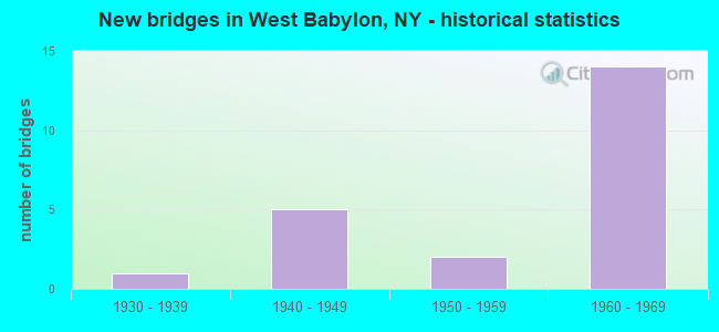
- New bridges - historical statistics
- 11930-1939
- 51940-1949
- 21950-1959
- 141960-1969


- Bridge Condition - Deck
- 20.0%Good
- 60.0%Satisfactory
- 20.0%Fair

- Bridge Condition - Superstructure
- 10.0%Very good
- 50.0%Good
- 30.0%Satisfactory
- 10.0%Fair

- Bridge Condition - Substructure
- 30.0%Very good
- 50.0%Good
- 20.0%Fair

- Bridge Condition - Channel
- 50.0%Very good
- 50.0%Fair
Find on map >> Show street view
Structure Number: 1018272, Location: JCT SH 27 & SH 109 (Lat: 40.710792, Lng: -73.367333), Route carried "on" structure: State highway 109, Year Built: 1968, Status: Open, Structure Length: 8.38m (27.49ft), Average Daily Traffic: 13,040 (year 2020), Truck Traffic: 9%, Average Future Daily Traffic: 15,045 (year 2040), Design Load: HS 20, Features Intersected: 27 27 07051036 EB, 27
Minimum Vertical Clearance: 30+ m (98+ ft), Kilometerpoint: 5.792, Lanes on structure: 3, Lanes under structure: 12, Base Highway Network: Yes, Owner: State Highway Agency, Approaching Roadway Width: 11.6m (38.1ft), Skew: 1 degrees, Material/Design: Steel, Design/Construction: Stringer/Multi-beam, Number Of Spans In Main Unit: 4, Length of Maximum Span: 23.1m (75.8ft), Curb or Sidewalk Widths: Left: 1.4m (4.6ft), Right: 0.5m (1.6ft), Curb-To-Curb Width: 11.6m (38.1ft), Out-to-Out Width: 14.2m (46.6ft)
Condition: Deck: Satisfactory, Superstructure: Good, Substructure: Good, Operating Rating: 59.9 metric tons, Method Used To Determine Operating Rating: Load Factor (LF), Inventory Rating: 35.4 metric tons, Method Used To Determine Inventory Rating: Load Factor (LF), Structural Evaluation: Better than present minimum criteria, Deck Geometry: High priority of replacement, Underclear: High priority of corrective action, Approach Roadway Alignment: Better than present minimum criteria, Length Of Structure Improvement: 8.38m (27.49ft), Designated Inspection Frequency: Every 24 months, Inspection Date: July 2020, Bridge Improvement Cost: $4,475,000, Roadway Improvement Cost: $2,621,000, Total Project Cost: $7,096,000 ( Estimate for 2021), Deck Structure Type: Concrete Cast-file-Place, Wearing Surface/Protective System: Wearing Surface: Monolithic Concrete
Find on map >> Show street view
Structure Number: 101829, Location: .9 MI E JCT SH 27 & SH 10 (Lat: 40.713356, Lng: -73.348342), Route carried "on" structure: Alternate City street , Year Built: 1968, Status: Open, Structure Length: 8.23m (27.00ft), Average Daily Traffic: 7,790 (year 2020), Truck Traffic: 3%, Average Future Daily Traffic: 9,463 (year 2040), Design Load: HS 20, Features Intersected: 27 27 07051047 Service,, Facility Carried by Structure: BELMONT AVE
Minimum Vertical Clearance: 30+ m (98+ ft), Kilometerpoint: 0.434, Lanes on structure: 4, Lanes under structure: 10, Owner: State Highway Agency, Approaching Roadway Width: 16.5m (54.1ft), Material/Design: Steel, Design/Construction: Stringer/Multi-beam, Number Of Spans In Main Unit: 4, Length of Maximum Span: 22.8m (74.8ft), Curb or Sidewalk Widths: Left: 2.3m (7.5ft), Right: 2.3m (7.5ft), Curb-To-Curb Width: 16.5m (54.1ft), Out-to-Out Width: 21.9m (71.9ft)
Condition: Deck: Good, Superstructure: Satisfactory, Substructure: Good, Operating Rating: 58.1 metric tons, Method Used To Determine Operating Rating: Load Factor (LF), Inventory Rating: 34.5 metric tons, Method Used To Determine Inventory Rating: Load Factor (LF), Structural Evaluation: Equal to present minimum criteria, Deck Geometry: Meets minimum limits, Underclear: High priority of corrective action, Approach Roadway Alignment: Equal to present desirable criteria, Length Of Structure Improvement: 8.22m (26.97ft), Designated Inspection Frequency: Every 24 months, Inspection Date: July 2020, Bridge Improvement Cost: $6,737,000, Roadway Improvement Cost: $3,945,000, Total Project Cost: $10,682,000 ( Estimate for 2021), Deck Structure Type: Concrete Cast-file-Place, Wearing Surface/Protective System: Wearing Surface: Monolithic Concrete
Find on map >> Show street view
Structure Number: 1018309, Location: 1.4 MI E JCT SH 27 & SH 1 (Lat: 40.713767, Lng: -73.339050), Route carried "on" structure: State highway 27, Year Built: 1968, Status: Open, Structure Length: 4.15m (13.62ft), Average Daily Traffic: 73,172 (year 2020), Truck Traffic: 9%, Average Future Daily Traffic: 87,038 (year 2040), Design Load: HS 20, Features Intersected: HUBBARDS PATH
Minimum Vertical Clearance: 30+ m (98+ ft), Kilometerpoint: 8.319, Lanes on structure: 6, Lanes under structure: 4, Base Highway Network: Yes, Owner: State Highway Agency, Approaching Roadway Width: 31.4m (103.0ft), Skew: 22 degrees, Material/Design: Steel, Design/Construction: Stringer/Multi-beam, Number Of Spans In Main Unit: 3, Length of Maximum Span: 22.8m (74.8ft), Curb-To-Curb Width: 31.4m (103.0ft), Out-to-Out Width: 33.4m (109.6ft)
Condition: Deck: Satisfactory, Superstructure: Satisfactory, Substructure: Fair, Operating Rating: 28.2 metric tons, Method Used To Determine Operating Rating: Load and Resistance Factor Rating (LRFR) rating reported by rating factor(RF) method using HL-93 loadings, Inventory Rating: 21.7 metric tons, Method Used To Determine Inventory Rating: Load and Resistance Factor Rating (LRFR) rating reported by rating factor(RF) method using HL-93 loadings, Structural Evaluation: Somewhat better than minimum adequacy, Deck Geometry: Superior to present desirable criteria, Underclear: Somewhat better than minimum adequacy, Approach Roadway Alignment: Equal to present desirable criteria, Length Of Structure Improvement: 4.14m (13.58ft), Designated Inspection Frequency: Every 24 months, Inspection Date: July 2020, Bridge Improvement Cost: $5,671,000, Roadway Improvement Cost: $3,321,000, Total Project Cost: $8,993,000 ( Estimate for 2021), Deck Structure Type: Concrete Cast-file-Place, Wearing Surface/Protective System: Wearing Surface: Monolithic Concrete
Find on map >> Show street view
Structure Number: 105778, Location: 2.2 MI W JCT SH 231 & SSP (Lat: 40.730378, Lng: -73.364469), Route carried "on" structure: Other road , Year Built: 1959, Status: Open, Structure Length: 2.29m (7.51ft), Average Daily Traffic: 11,090 (year 2019), Truck Traffic: 5%, Average Future Daily Traffic: 13,472 (year 2040), Design Load: HS 20, Features Intersected: RTE 908M, Facility Carried by Structure: LITTLE EAST NECK R
Minimum Vertical Clearance: 30+ m (98+ ft), Kilometerpoint: 3.492, Lanes on structure: 2, Lanes under structure: 3, Owner: State Highway Agency, Approaching Roadway Width: 12.2m (40.0ft), Material/Design: Concrete, Design/Construction: Arch - Deck, Number Of Spans In Main Unit: 1, Length of Maximum Span: 21.3m (69.9ft), Curb or Sidewalk Widths: Left: 1.5m (4.9ft), Right: 1.5m (4.9ft), Curb-To-Curb Width: 12.2m (40.0ft), Out-to-Out Width: 16.2m (53.1ft)
Condition: Superstructure: Good, Substructure: Very good, Operating Rating: 87.8 metric tons, Method Used To Determine Operating Rating: Field evaluation and documented engineering judgment, Inventory Rating: 32.7 metric tons, Method Used To Determine Inventory Rating: Field evaluation and documented engineering judgment, Structural Evaluation: Better than present minimum criteria, Deck Geometry: Somewhat better than minimum adequacy, Underclear: High priority of corrective action, Approach Roadway Alignment: Equal to present desirable criteria, Length Of Structure Improvement: 2.28m (7.48ft), Designated Inspection Frequency: Every 24 months, Inspection Date: November 2020, Bridge Improvement Cost: $2,753,000, Roadway Improvement Cost: $1,612,000, Total Project Cost: $4,365,000 ( Estimate for 2021), Wearing Surface/Protective System: Wearing Surface: Bituminous
Find on map >> Show street view
Structure Number: 105779, Location: 1.3 MI W JCT RTS 231+SSP (Lat: 40.732339, Lng: -73.346028), Route carried "on" structure: Other road , Year Built: 1960, Status: Open, Structure Length: 2.37m (7.78ft), Average Daily Traffic: 20,671 (year 2020), Truck Traffic: 4%, Average Future Daily Traffic: 25,111 (year 2040), Design Load: HS 20, Features Intersected: RTE 908M, Facility Carried by Structure: BELMONT AVENUE
Minimum Vertical Clearance: 30+ m (98+ ft), Kilometerpoint: 2.574, Lanes on structure: 4, Lanes under structure: 4, Owner: State Highway Agency, Approaching Roadway Width: 14.6m (47.9ft), Skew: 1 degrees, Material/Design: Concrete, Design/Construction: Arch - Deck, Number Of Spans In Main Unit: 1, Length of Maximum Span: 21.9m (71.9ft), Curb or Sidewalk Widths: Left: 1.7m (5.6ft), Right: 1.8m (5.9ft), Curb-To-Curb Width: 14.6m (47.9ft), Out-to-Out Width: 18.6m (61.0ft)
Condition: Superstructure: Satisfactory, Substructure: Good, Operating Rating: 61.7 metric tons, Method Used To Determine Operating Rating: Load Factor (LF), Inventory Rating: 36.3 metric tons, Method Used To Determine Inventory Rating: Load Factor (LF), Structural Evaluation: Equal to present minimum criteria, Deck Geometry: High priority of replacement, Underclear: High priority of corrective action, Approach Roadway Alignment: Better than present minimum criteria, Length Of Structure Improvement: 2.37m (7.78ft), Designated Inspection Frequency: Every 24 months, Inspection Date: Febuary 2020, Bridge Improvement Cost: $3,290,000, Roadway Improvement Cost: $1,927,000, Total Project Cost: $5,217,000 ( Estimate for 2021), Wearing Surface/Protective System: Wearing Surface: Bituminous, Membrane: Preformed Fabric
Find on map >> Show street view
Structure Number: 1059779, Location: 1.8 MI E JCT SH 109 & SSP (Lat: 40.726978, Lng: -73.374831), Route carried "on" structure: State highway 908M, Year Built: 1941, Status: Open, Structure Length: 2.25m (7.38ft), Average Daily Traffic: 130,226 (year 2020), Average Future Daily Traffic: 154,903 (year 2040), Design Load: HS 20, Features Intersected: STRAIGHT PATH
Minimum Vertical Clearance: 30+ m (98+ ft), Kilometerpoint: 5.422, Lanes on structure: 8, Lanes under structure: 4, Base Highway Network: Yes, Owner: State Highway Agency, Approaching Roadway Width: 35.4m (116.1ft), Skew: 24 degrees, Material/Design: Concrete, Design/Construction: Frame, Number Of Spans In Main Unit: 1, Length of Maximum Span: 21.0m (68.9ft), Curb-To-Curb Width: 35.4m (116.1ft), Out-to-Out Width: 37.2m (122.0ft)
Condition: Deck: Fair, Superstructure: Fair, Substructure: Fair, Operating Rating: 87.5 metric tons, Method Used To Determine Operating Rating: Field evaluation and documented engineering judgment, Inventory Rating: 32.7 metric tons, Method Used To Determine Inventory Rating: Field evaluation and documented engineering judgment, Structural Evaluation: Somewhat better than minimum adequacy, Deck Geometry: Equal to present minimum criteria, Underclear: High priority of corrective action, Approach Roadway Alignment: Better than present minimum criteria, Length Of Structure Improvement: 2.25m (7.38ft), Designated Inspection Frequency: Every 24 months, Inspection Date: Febuary 2020, Bridge Improvement Cost: $5,645,000, Roadway Improvement Cost: $3,306,000, Total Project Cost: $8,951,000 ( Estimate for 2021), Wearing Surface/Protective System: Wearing Surface: Bituminous, Membrane: Preformed Fabric
Find on map >> Show street view
Structure Number: 105978, Location: 2.2 MI W JCT SH 231 & SSP (Lat: 40.730158, Lng: -73.364275), Route carried "on" structure: Other road , Year Built: 1941, Status: Open, Structure Length: 2.56m (8.40ft), Average Daily Traffic: 11,090 (year 2019), Truck Traffic: 5%, Average Future Daily Traffic: 13,472 (year 2040), Design Load: H 20, Features Intersected: RTE 908M, Facility Carried by Structure: LITTLE EAST NECK R
Minimum Vertical Clearance: 30+ m (98+ ft), Kilometerpoint: 3.443, Lanes on structure: 2, Lanes under structure: 3, Owner: State Highway Agency, Approaching Roadway Width: 12.2m (40.0ft), Material/Design: Concrete, Design/Construction: Arch - Deck, Number Of Spans In Main Unit: 1, Length of Maximum Span: 23.7m (77.8ft), Curb or Sidewalk Widths: Left: 1.7m (5.6ft), Right: 1.7m (5.6ft), Curb-To-Curb Width: 12.2m (40.0ft), Out-to-Out Width: 16.2m (53.1ft)
Condition: Superstructure: Good, Substructure: Very good, Operating Rating: 63.4 metric tons, Method Used To Determine Operating Rating: Field evaluation and documented engineering judgment, Inventory Rating: 24.2 metric tons, Method Used To Determine Inventory Rating: Field evaluation and documented engineering judgment, Structural Evaluation: Somewhat better than minimum adequacy, Deck Geometry: Somewhat better than minimum adequacy, Underclear: High priority of corrective action, Approach Roadway Alignment: Equal to present desirable criteria, Length Of Structure Improvement: 2.56m (8.40ft), Designated Inspection Frequency: Every 24 months, Inspection Date: November 2020, Bridge Improvement Cost: $2,785,000, Roadway Improvement Cost: $1,631,000, Total Project Cost: $4,417,000 ( Estimate for 2021), Wearing Surface/Protective System: Wearing Surface: Bituminous
Find on map >> Show street view
Structure Number: 105979, Location: 1.3 MI W JCT RTS 231+SSP (Lat: 40.732047, Lng: -73.345944), Route carried "on" structure: City street , Year Built: 1960, Status: Open, Structure Length: 2.37m (7.78ft), Average Daily Traffic: 20,671 (year 2020), Truck Traffic: 4%, Average Future Daily Traffic: 25,111 (year 2040), Design Load: HS 20, Features Intersected: RTE 908M, Facility Carried by Structure: BELMONT AVENUE
Minimum Vertical Clearance: 30+ m (98+ ft), Kilometerpoint: 2.542, Lanes on structure: 4, Lanes under structure: 4, Owner: State Highway Agency, Approaching Roadway Width: 14.6m (47.9ft), Skew: 1 degrees, Material/Design: Concrete, Design/Construction: Arch - Deck, Number Of Spans In Main Unit: 1, Length of Maximum Span: 21.9m (71.9ft), Curb or Sidewalk Widths: Left: 1.4m (4.6ft), Right: 1.5m (4.9ft), Curb-To-Curb Width: 14.6m (47.9ft), Out-to-Out Width: 18.6m (61.0ft)
Condition: Superstructure: Good, Substructure: Good, Operating Rating: 61.7 metric tons, Method Used To Determine Operating Rating: Load Factor (LF), Inventory Rating: 36.3 metric tons, Method Used To Determine Inventory Rating: Load Factor (LF), Structural Evaluation: Better than present minimum criteria, Deck Geometry: High priority of replacement, Underclear: High priority of corrective action, Approach Roadway Alignment: Equal to present desirable criteria, Length Of Structure Improvement: 2.37m (7.78ft), Designated Inspection Frequency: Every 24 months, Inspection Date: Febuary 2020, Bridge Improvement Cost: $3,290,000, Roadway Improvement Cost: $1,927,000, Total Project Cost: $5,217,000 ( Estimate for 2021), Wearing Surface/Protective System: Wearing Surface: Bituminous, Membrane: Preformed Fabric
Find on map >> Show street view
Structure Number: 1059809, Location: BETWEEN EXITS 37 & 38 - S (Lat: 40.732553, Lng: -73.341594), Route carried "on" structure: State highway 908M, Year Built: 1933, Status: Open, Structure Length: 1.10m (3.61ft), Average Daily Traffic: 130,667 (year 2020), Average Future Daily Traffic: 155,428 (year 2040), Design Load: H 20, Features Intersected: CARLLS RIVER, PEDESTRIAN
Minimum Vertical Clearance: 30+ m (98+ ft), Kilometerpoint: 8.335, Lanes on structure: 6, Base Highway Network: Yes, Owner: State Highway Agency, Approaching Roadway Width: 28.0m (91.9ft), Skew: 20 degrees, Material/Design: Concrete, Design/Construction: Arch - Deck, Number Of Spans In Main Unit: 1, Length of Maximum Span: 9.7m (31.8ft), Curb-To-Curb Width: 28.0m (91.9ft), Out-to-Out Width: 31.3m (102.7ft)
Condition: Superstructure: Very good, Substructure: Very good, Channel: Very good, Operating Rating: 65.1 metric tons, Method Used To Determine Operating Rating: Field evaluation and documented engineering judgment, Inventory Rating: 27.8 metric tons, Method Used To Determine Inventory Rating: Field evaluation and documented engineering judgment, Structural Evaluation: Equal to present minimum criteria, Deck Geometry: Equal to present minimum criteria, Waterway Adequacy: Superior to present desirable criteria, Approach Roadway Alignment: Equal to present desirable criteria, Length Of Structure Improvement: 1.09m (3.58ft), Designated Inspection Frequency: Every 24 months, Inspection Date: August 2020, Bridge Improvement Cost: $1,572,000, Roadway Improvement Cost: $921,000, Total Project Cost: $2,493,000 ( Estimate for 2021), Wearing Surface/Protective System: Wearing Surface: Bituminous, Membrane: Preformed Fabric
Find on map >> Show street view
Structure Number: 106086, Location: .8 MI E JCT SH 27 & SH 10 (Lat: 40.713314, Lng: -73.351133), Route carried "on" structure: Other road , Year Built: 1968, Status: Open, Structure Length: 8.87m (29.10ft), Average Daily Traffic: 14,551 (year 2018), Truck Traffic: 2%, Average Future Daily Traffic: 17,676 (year 2040), Design Load: HS 20, Features Intersected: 27 27 07051046, WB, 27, Facility Carried by Structure: LITTLE E NECK RD
Minimum Vertical Clearance: 30+ m (98+ ft), Kilometerpoint: 1.255, Lanes on structure: 4, Lanes under structure: 10, Owner: State Highway Agency, Approaching Roadway Width: 16.5m (54.1ft), Skew: 22 degrees, Material/Design: Steel, Design/Construction: Stringer/Multi-beam, Number Of Spans In Main Unit: 4, Length of Maximum Span: 24.9m (81.7ft), Curb or Sidewalk Widths: Left: 2.3m (7.5ft), Right: 2.3m (7.5ft), Curb-To-Curb Width: 16.5m (54.1ft), Out-to-Out Width: 21.9m (71.9ft)
Condition: Deck: Satisfactory, Superstructure: Good, Substructure: Good, Operating Rating: 61.6 metric tons, Method Used To Determine Operating Rating: Load and Resistance Factor Rating (LRFR) rating reported by rating factor(RF) method using HL-93 loadings, Inventory Rating: 47.6 metric tons, Method Used To Determine Inventory Rating: Load and Resistance Factor Rating (LRFR) rating reported by rating factor(RF) method using HL-93 loadings, Structural Evaluation: Better than present minimum criteria, Deck Geometry: Meets minimum limits, Underclear: High priority of corrective action, Approach Roadway Alignment: Better than present minimum criteria, Length Of Structure Improvement: 8.86m (29.07ft), Designated Inspection Frequency: Every 24 months, Inspection Date: July 2020, Bridge Improvement Cost: $7,252,000, Roadway Improvement Cost: $4,246,000, Total Project Cost: $11,498,000 ( Estimate for 2021), Deck Structure Type: Concrete Cast-file-Place, Wearing Surface/Protective System: Wearing Surface: Monolithic Concrete
Find on map >> Show street view
Structure Number: 226912, Location: 0.6 MI N OF BELMONT & SSP (Lat: 40.741056, Lng: -73.344150), Route carried "on" structure: City street , Year Built: 1940, Status: Open, Structure Length: 1.31m (4.30ft), Average Daily Traffic: 14,336 (year 2020), Truck Traffic: 3%, Average Future Daily Traffic: 17,737 (year 2040), Features Intersected: CARLLS RIVER, Facility Carried by Structure: AUGUST AVENUE
Minimum Vertical Clearance: 30+ m (98+ ft), Kilometerpoint: 1.947, Lanes on structure: 2, Owner: Town or Township Highway Agency, Approaching Roadway Width: 11.6m (38.1ft), Skew: 4 degrees, Material/Design: Concrete, Design/Construction: Culvert, Number Of Spans In Main Unit: 3, Length of Maximum Span: 3.9m (12.8ft), Curb-To-Curb Width: 14.3m (46.9ft), Out-to-Out Width: 16.1m (52.8ft)
Condition: Channel: Fair, Culverts: Satisfactory, Operating Rating: 71.8 metric tons, Method Used To Determine Operating Rating: Field evaluation and documented engineering judgment, Inventory Rating: 32.7 metric tons, Method Used To Determine Inventory Rating: Field evaluation and documented engineering judgment, Structural Evaluation: Equal to present minimum criteria, Deck Geometry: Superior to present desirable criteria, Waterway Adequacy: Meets minimum limits, Approach Roadway Alignment: Equal to present minimum criteria, Length Of Structure Improvement: 1.31m (4.30ft), Designated Inspection Frequency: Every 24 months, Inspection Date: May 2021, Bridge Improvement Cost: $629,000, Roadway Improvement Cost: $368,000, Total Project Cost: $997,000 ( Estimate for 2021)
Find on map >> Show street view
Structure Number: 1018272, Location: JCT SH 27 & SH 109 (Lat: 40.710792, Lng: -73.367333), Route carried "under" structure: State highway 27, Year Built: 1968, Structure Length: 0. m, Average Daily Traffic: 24,600 (year 1973), Features Intersected: 27 27 07051036 EB, 27, Facility Carried by Structure: RTE 109
Minimum Vertical Clearance: 4.60m (15.09ft), Kilometerpoint: 5.857, Lanes on structure: 3, Lanes under structure: 3, Material/Design: Steel, Design/Construction: Stringer/Multi-beam, Length of Maximum Span: 23.1m (75.8ft)
Find on map >> Show street view
Structure Number: 101829, Location: .9 MI E JCT SH 27 & SH 10 (Lat: 40.713356, Lng: -73.348342), Route carried "under" structure: State highway 27, Year Built: 1968, Structure Length: 0. m, Average Daily Traffic: 35,300 (year 1973), Features Intersected: 27 27 07051047 Service,, Facility Carried by Structure: BELMONT AVE
Minimum Vertical Clearance: 4.42m (14.50ft), Kilometerpoint: 7.482, Lanes on structure: 4, Lanes under structure: 3, Material/Design: Steel, Design/Construction: Stringer/Multi-beam, Length of Maximum Span: 22.8m (74.8ft)
Find on map >> Show street view
Structure Number: 1018309, Location: 1.4 MI E JCT SH 27 & SH 1 (Lat: 40.713767, Lng: -73.339050), Route carried "under" structure: Other road , Year Built: 1968, Structure Length: 0. m, Average Daily Traffic: 11,000 (year 2021), Features Intersected: HUBBARDS PATH, Facility Carried by Structure: RTE 27
Minimum Vertical Clearance: 4.37m (14.34ft), Kilometerpoint: 0.000, Lanes on structure: 6, Lanes under structure: 4, Material/Design: Steel, Design/Construction: Stringer/Multi-beam, Length of Maximum Span: 22.8m (74.8ft)
Find on map >> Show street view
Structure Number: 105778, Location: 2.2 MI W JCT SH 231 & SSP (Lat: 40.730378, Lng: -73.364469), Route carried "under" structure: State highway 908M, Year Built: 1959, Structure Length: 0. m, Average Daily Traffic: 131,621 (year 2002), Features Intersected: RTE 908M, Facility Carried by Structure: LITTLE EAST NECK R
Minimum Vertical Clearance: 4.22m (13.85ft), Kilometerpoint: 6.018, Lanes on structure: 2, Lanes under structure: 3, Material/Design: Concrete, Design/Construction: Arch - Deck, Length of Maximum Span: 21.3m (69.9ft)
Find on map >> Show street view
Structure Number: 105779, Location: 1.3 MI W JCT RTS 231+SSP (Lat: 40.732339, Lng: -73.346028), Route carried "under" structure: State highway 908M, Year Built: 1960, Structure Length: 0. m, Average Daily Traffic: 131,621 (year 2002), Features Intersected: RTE 908M, Facility Carried by Structure: BELMONT AVENUE
Minimum Vertical Clearance: 4.24m (13.91ft), Kilometerpoint: 7.627, Lanes on structure: 4, Lanes under structure: 4, Material/Design: Concrete, Design/Construction: Arch - Deck, Length of Maximum Span: 21.9m (71.9ft)
Find on map >> Show street view
Structure Number: 1059779, Location: 1.8 MI E JCT SH 109 & SSP (Lat: 40.726978, Lng: -73.374831), Route carried "under" structure: County highway , Year Built: 1941, Structure Length: 0. m, Average Daily Traffic: 33,740 (year 2005), Features Intersected: STRAIGHT PATH, Facility Carried by Structure: RTE 908M
Minimum Vertical Clearance: 4.72m (15.49ft), Kilometerpoint: 0.000, Lanes on structure: 8, Lanes under structure: 4, Material/Design: Concrete, Design/Construction: Frame, Length of Maximum Span: 21.0m (68.9ft)
Find on map >> Show street view
Structure Number: 105978, Location: 2.2 MI W JCT SH 231 & SSP (Lat: 40.730158, Lng: -73.364275), Route carried "under" structure: State highway 908M, Year Built: 1941, Structure Length: 0. m, Average Daily Traffic: 131,621 (year 2002), Features Intersected: RTE 908M, Facility Carried by Structure: LITTLE EAST NECK R
Minimum Vertical Clearance: 4.39m (14.40ft), Kilometerpoint: 6.018, Lanes on structure: 2, Lanes under structure: 3, Material/Design: Concrete, Design/Construction: Arch - Deck, Length of Maximum Span: 23.7m (77.8ft)
Find on map >> Show street view
Structure Number: 105979, Location: 1.3 MI W JCT RTS 231+SSP (Lat: 40.732047, Lng: -73.345944), Route carried "under" structure: State highway 908M, Year Built: 1960, Structure Length: 0. m, Average Daily Traffic: 131,621 (year 2002), Features Intersected: RTE 908M, Facility Carried by Structure: BELMONT AVENUE
Minimum Vertical Clearance: 4.24m (13.91ft), Kilometerpoint: 7.627, Lanes on structure: 4, Lanes under structure: 4, Material/Design: Concrete, Design/Construction: Arch - Deck, Length of Maximum Span: 21.9m (71.9ft)
Find on map >> Show street view
Structure Number: 106086, Location: .8 MI E JCT SH 27 & SH 10 (Lat: 40.713314, Lng: -73.351133), Route carried "under" structure: ServiceState highway 27, Year Built: 1968, Structure Length: 0. m, Average Daily Traffic: 35,300 (year 1973), Features Intersected: 27 27 07051046, WB, 27, Facility Carried by Structure: LITTLE E NECK RD
Minimum Vertical Clearance: 4.29m (14.07ft), Kilometerpoint: 7.241, Lanes on structure: 4, Lanes under structure: 2, Material/Design: Steel, Design/Construction: Stringer/Multi-beam, Length of Maximum Span: 24.9m (81.7ft)
Find on map >> Show street view
Structure Number: 770964, Location: 1.1 MI WEST OF BABYLON (Lat: 40.695675, Lng: -73.343722), Route carried "under" structure: County highway , Year Built: 1963, Structure Length: 0. m, Average Daily Traffic: 15,850 (year 1978), Features Intersected: GREAT E NECK RD, Facility Carried by Structure: LIRR CENTRAL BR
Minimum Vertical Clearance: 4.31m (14.14ft), Kilometerpoint: 0.000, Lanes under structure: 4, Material/Design: Steel, Design/Construction: Girder and Floorbeam System, Length of Maximum Span: 25.9m (85.0ft)
Find on map >> Show street view
Structure Number: 770998, Location: 1.1 MI WEST OF BABYLON (Lat: 40.695269, Lng: -73.343878), Route carried "under" structure: County highway , Year Built: 1963, Structure Length: 0. m, Average Daily Traffic: 12,400 (year 1977), Features Intersected: GREAT E NECK RD, Facility Carried by Structure: LIRR MONTAUK BR
Minimum Vertical Clearance: 4.47m (14.67ft), Kilometerpoint: 0.000, Lanes under structure: 4, Material/Design: Steel, Design/Construction: Girder and Floorbeam System, Length of Maximum Span: 32.3m (106.0ft)