Bridge Statistics for Wellington, Florida (FL)
Condition, Traffic, Stress, Structural Evaluation, Project Costs
- National Bridge Inventory (NBI) Statistics
- 24Number of bridges
- 285ft / 86.6mTotal length
- 571,039Total average daily traffic
- 59,582Total average daily truck traffic
- National Bridge Inventory (NBI) Registered Bridges for Wellington
- No street view available for this location
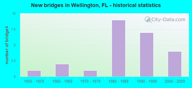
- New bridges - historical statistics
- 11950-1959
- 21960-1969
- 11970-1979
- 91980-1989
- 71990-1999
- 42000-2009

- Reconstructed bridges - Historical Statistics
- 21990-1999
- 22000-2009


- Bridge Condition - Deck
- 15.0%Very good
- 60.0%Good
- 20.0%Satisfactory
- 5.0%Fair

- Bridge Condition - Superstructure
- 5.0%Excellent
- 20.0%Very good
- 55.0%Good
- 15.0%Satisfactory
- 5.0%Fair

- Bridge Condition - Substructure
- 5.0%Excellent
- 5.0%Very good
- 80.0%Good
- 10.0%Satisfactory

- Bridge Condition - Channel
- 5.0%Excellent
- 30.0%Very good
- 40.0%Good
- 15.0%Satisfactory
- 10.0%Fair
Find on map >> Show street view
Structure Number: 930085, Location: INT. OF CR-700 & CR-880 (Lat: 26.684653, Lng: -80.390347), Route carried "on" structure: County highway 700, Year Built: 1968, Status: Open, Structure Length: 4.27m (14.01ft), Average Daily Traffic: 100 (year 2022), Truck Traffic: 22%, Average Future Daily Traffic: 174 (year 2042), Design Load: HS 20, Features Intersected: SFWMD L-13 CANAL
Minimum Vertical Clearance: 30+ m (98+ ft), Kilometerpoint: 0.026, Lanes on structure: 2, Owner: County Highway Agency, Approaching Roadway Width: 8.8m (28.9ft), Material/Design: Prestressed concrete, Design/Construction: Slab, Number Of Spans In Main Unit: 5, Length of Maximum Span: 9.1m (29.9ft), Curb-To-Curb Width: 10.1m (33.1ft), Out-to-Out Width: 10.8m (35.4ft)
Condition: Deck: Good, Superstructure: Good, Substructure: Satisfactory, Channel: Good, Operating Rating: 74.5 metric tons, Method Used To Determine Operating Rating: Load Factor (LF), Inventory Rating: 44.7 metric tons, Method Used To Determine Inventory Rating: Load Factor (LF), Structural Evaluation: Equal to present minimum criteria, Deck Geometry: Superior to present desirable criteria, Waterway Adequacy: Equal to present desirable criteria, Approach Roadway Alignment: Equal to present desirable criteria, Designated Inspection Frequency: Every 24 months, Underwater Inspection Frequency: Every 24 months, Inspection Date: Febuary 2022, Underwater Inspection Date: Febuary 2022, Deck Structure Type: Concrete Precast Panels, Wearing Surface/Protective System: Wearing Surface: Bituminous
Find on map >> Show street view
Structure Number: 930334, Location: LAKE WORTH INTERCHANGE (Lat: 26.620317, Lng: -80.171925), Route carried "on" structure: Ramp State highway 91, Year Built: 1956, Year Reconstructed: 2002, Status: Open, Structure Length: 2.42m (7.94ft), Average Daily Traffic: 7,650 (year 2021), Truck Traffic: 16%, Average Future Daily Traffic: 13,273 (year 2042), Design Load: HS 20, Features Intersected: LAT CANAL (LK WORTH INT)
Minimum Vertical Clearance: 30.45m (99.90ft), Kilometerpoint: 0.295, Lanes on structure: 5, Toll: On toll road, Owner: State Toll Authority, Approaching Roadway Width: 23.0m (75.5ft), Skew: 33 degrees, Material/Design: Concrete, Design/Construction: Slab, Number Of Spans In Main Unit: 3, Length of Maximum Span: 10.5m (34.4ft), Curb-To-Curb Width: 22.9m (75.1ft), Out-to-Out Width: 24.5m (80.4ft)
Condition: Deck: Satisfactory, Superstructure: Satisfactory, Substructure: Good, Channel: Good, Operating Rating: 41.8 metric tons, Method Used To Determine Operating Rating: Load Factor (LF), Inventory Rating: 25.8 metric tons, Method Used To Determine Inventory Rating: Load Factor (LF), Structural Evaluation: Equal to present minimum criteria, Deck Geometry: Superior to present desirable criteria, Waterway Adequacy: Better than present minimum criteria, Approach Roadway Alignment: Somewhat better than minimum adequacy, Designated Inspection Frequency: Every 24 months, Inspection Date: November 2021, Deck Structure Type: Concrete Cast-file-Place
Find on map >> Show street view
Structure Number: 930406, Location: 6.8 miles W of US 441 (Lat: 26.683578, Lng: -80.312350), Route carried "on" structure: Alternate State highway 80, Year Built: 1989, Status: Open, Structure Length: 0.77m (2.53ft), Average Daily Traffic: 23,000 (year 2018), Truck Traffic: 9%, Average Future Daily Traffic: 39,905 (year 2040), Design Load: HS 20, Features Intersected: A DRAINAGE CANAL
Minimum Vertical Clearance: 30+ m (98+ ft), Kilometerpoint: 7.887, Lanes on structure: 4, Base Highway Network: Yes, Owner: State Highway Agency, Approaching Roadway Width: 18.2m (59.7ft), Skew: 20 degrees, Material/Design: Concrete, Design/Construction: Culvert, Number Of Spans In Main Unit: 3, Length of Maximum Span: 2.4m (7.9ft)
Condition: Channel: Satisfactory, Culverts: Satisfactory, Inventory Rating: 55.3 metric tons, Method Used To Determine Inventory Rating: Load Factor (LF), Structural Evaluation: Equal to present minimum criteria, Waterway Adequacy: Superior to present desirable criteria, Approach Roadway Alignment: Equal to present desirable criteria, Designated Inspection Frequency: Every 24 months, Underwater Inspection Frequency: Every 24 months, Inspection Date: January 2021, Underwater Inspection Date: January 2021, Wearing Surface/Protective System: Wearing Surface: Bituminous
Find on map >> Show street view
Structure Number: 930407, Location: PUMP STA AT 20 MI BEND (Lat: 26.685339, Lng: -80.364069), Route carried "on" structure: US 98, Year Built: 1988, Status: Open, Structure Length: 5.95m (19.52ft), Average Daily Traffic: 8,450 (year 2020), Truck Traffic: 20%, Average Future Daily Traffic: 14,661 (year 2042), Design Load: HS 20, Features Intersected: LEVEE NO.8, Facility Carried by Structure: SR-80WB (Southern)
Minimum Vertical Clearance: 30+ m (98+ ft), Kilometerpoint: 2.704, Lanes on structure: 2, Base Highway Network: Yes, Owner: State Highway Agency, Approaching Roadway Width: 7.9m (25.9ft), Material/Design: Prestressed concrete, Design/Construction: Stringer/Multi-beam, Number Of Spans In Main Unit: 3, Length of Maximum Span: 19.8m (65.0ft), Curb-To-Curb Width: 12.1m (39.7ft), Out-to-Out Width: 13.0m (42.7ft)
Condition: Deck: Satisfactory, Superstructure: Good, Substructure: Good, Channel: Very good, Operating Rating: 76.3 metric tons, Method Used To Determine Operating Rating: Load Factor (LF), Inventory Rating: 45.7 metric tons, Method Used To Determine Inventory Rating: Load Factor (LF), Structural Evaluation: Better than present minimum criteria, Deck Geometry: Better than present minimum criteria, Waterway Adequacy: Better than present minimum criteria, Approach Roadway Alignment: Equal to present desirable criteria, Designated Inspection Frequency: Every 24 months, Underwater Inspection Frequency: Every 24 months, Inspection Date: December 2020, Underwater Inspection Date: December 2020, Deck Structure Type: Concrete Cast-file-Place
Find on map >> Show street view
Structure Number: 930408, Location: PUMP STA. AT 20 MI. BEND (Lat: 26.684847, Lng: -80.364361), Route carried "on" structure: US 98, Year Built: 1989, Status: Open, Structure Length: 4.96m (16.27ft), Average Daily Traffic: 8,450 (year 2020), Truck Traffic: 20%, Average Future Daily Traffic: 14,661 (year 2042), Design Load: HS 20, Features Intersected: LEVEE NO. 8, Facility Carried by Structure: SR-80EB (Southern)
Minimum Vertical Clearance: 30+ m (98+ ft), Kilometerpoint: 2.704, Lanes on structure: 2, Base Highway Network: Yes, Owner: State Highway Agency, Approaching Roadway Width: 8.4m (27.6ft), Material/Design: Prestressed concrete, Design/Construction: Stringer/Multi-beam, Number Of Spans In Main Unit: 3, Length of Maximum Span: 19.8m (65.0ft), Curb-To-Curb Width: 12.1m (39.7ft), Out-to-Out Width: 13.0m (42.7ft)
Condition: Deck: Good, Superstructure: Good, Substructure: Good, Channel: Good, Operating Rating: 66.3 metric tons, Method Used To Determine Operating Rating: Load Factor (LF), Inventory Rating: 39.8 metric tons, Method Used To Determine Inventory Rating: Load Factor (LF), Structural Evaluation: Better than present minimum criteria, Deck Geometry: Better than present minimum criteria, Waterway Adequacy: Better than present minimum criteria, Approach Roadway Alignment: Equal to present desirable criteria, Designated Inspection Frequency: Every 24 months, Underwater Inspection Frequency: Every 24 months, Inspection Date: December 2020, Underwater Inspection Date: December 2020, Deck Structure Type: Concrete Cast-file-Place
Find on map >> Show street view
Structure Number: 930413, Location: Lake Worth Rd. at SR-7 (Lat: 26.617222, Lng: -80.204486), Route carried "on" structure: State highway 802, Year Built: 1990, Year Reconstructed: 2006, Status: Open, Structure Length: 1.10m (3.61ft), Average Daily Traffic: 38,000 (year 2020), Truck Traffic: 7%, Average Future Daily Traffic: 65,930 (year 2042), Design Load: HS 20, Features Intersected: LWDD E-1 Canal, Facility Carried by Structure: Lake Worth Road
Minimum Vertical Clearance: 30+ m (98+ ft), Kilometerpoint: 0.040, Lanes on structure: 9, Base Highway Network: Yes, Owner: State Highway Agency, Approaching Roadway Width: 33.7m (110.6ft), Skew: 20 degrees, Material/Design: Prestressed concrete, Design/Construction: Slab, Number Of Spans In Main Unit: 1, Length of Maximum Span: 11.0m (36.1ft), Curb or Sidewalk Widths: Left: 1.9m (6.2ft), Right: 2.3m (7.5ft), Curb-To-Curb Width: 37.4m (122.7ft), Out-to-Out Width: 42.5m (139.4ft)
Condition: Deck: Good, Superstructure: Good, Substructure: Good, Channel: Good, Operating Rating: 77.1 metric tons, Method Used To Determine Operating Rating: Load Factor (LF), Inventory Rating: 46.3 metric tons, Method Used To Determine Inventory Rating: Load Factor (LF), Structural Evaluation: Better than present minimum criteria, Deck Geometry: Equal to present minimum criteria, Waterway Adequacy: Superior to present desirable criteria, Approach Roadway Alignment: Equal to present desirable criteria, Designated Inspection Frequency: Every 24 months, Underwater Inspection Frequency: Every 24 months, Inspection Date: August 2020, Underwater Inspection Date: August 2020, Deck Structure Type: Concrete Precast Panels, Wearing Surface/Protective System: Wearing Surface: Bituminous
Find on map >> Show street view
Structure Number: 930456, Location: Lake Worth Rd at FL Trnpk (Lat: 26.617631, Lng: -80.172939), Route carried "on" structure: State highway 802, Year Built: 1994, Status: Open, Structure Length: 1.04m (3.41ft), Average Daily Traffic: 43,500 (year 2021), Truck Traffic: 8%, Average Future Daily Traffic: 75,472 (year 2042), Design Load: HS 20+Mod, Features Intersected: E-2-E Canal, Facility Carried by Structure: Lake Worth Road
Minimum Vertical Clearance: 30+ m (98+ ft), Kilometerpoint: 3.166, Lanes on structure: 9, Base Highway Network: Yes, Owner: State Highway Agency, Approaching Roadway Width: 28.7m (94.2ft), Skew: 20 degrees, Material/Design: Concrete, Design/Construction: Slab, Number Of Spans In Main Unit: 1, Length of Maximum Span: 10.4m (34.1ft), Curb or Sidewalk Widths: Left: 2.3m (7.5ft), Right: 2.3m (7.5ft), Curb-To-Curb Width: 36.0m (118.1ft), Out-to-Out Width: 41.6m (136.5ft)
Condition: Deck: Satisfactory, Superstructure: Satisfactory, Substructure: Good, Channel: Satisfactory, Operating Rating: 67.6 metric tons, Method Used To Determine Operating Rating: Load Factor (LF), Inventory Rating: 40.6 metric tons, Method Used To Determine Inventory Rating: Load Factor (LF), Structural Evaluation: Equal to present minimum criteria, Deck Geometry: Somewhat better than minimum adequacy, Waterway Adequacy: Superior to present desirable criteria, Approach Roadway Alignment: Equal to present desirable criteria, Designated Inspection Frequency: Every 24 months, Underwater Inspection Frequency: Every 24 months, Inspection Date: June 2021, Underwater Inspection Date: June 2021, Deck Structure Type: Concrete Cast-file-Place
Find on map >> Show street view
Structure Number: 930514, Location: 1.7 miles east of SR 7 (Lat: 26.650989, Lng: -80.174125), Route carried "on" structure: State highway 882, Year Built: 2002, Status: Open, Structure Length: 15.24m (50.00ft), Average Daily Traffic: 17,750 (year 2018), Truck Traffic: 4%, Average Future Daily Traffic: 30,796 (year 2040), Design Load: HL 93, Features Intersected: Fla. Turnpike & 2 canals, Facility Carried by Structure: WB Forest Hill Bld
Minimum Vertical Clearance: 30+ m (98+ ft), Kilometerpoint: 2.858, Lanes on structure: 3, Lanes under structure: 4, Base Highway Network: Yes, Owner: State Highway Agency, Approaching Roadway Width: 12.5m (41.0ft), Material/Design: Prestressed concrete, Design/Construction: Stringer/Multi-beam, Number Of Spans In Main Unit: 6, Length of Maximum Span: 24.7m (81.0ft), Curb or Sidewalk Widths: Left: 1.3m (4.3ft), Right: 0.0m, Curb-To-Curb Width: 14.7m (48.2ft), Out-to-Out Width: 15.9m (52.2ft)
Condition: Deck: Good, Superstructure: Very good, Substructure: Good, Channel: Fair, Operating Rating: 67.0 metric tons, Method Used To Determine Operating Rating: Load Factor (LF), Inventory Rating: 41.5 metric tons, Method Used To Determine Inventory Rating: Load Factor (LF), Structural Evaluation: Better than present minimum criteria, Deck Geometry: Somewhat better than minimum adequacy, Underclear: Somewhat better than minimum adequacy, Waterway Adequacy: Superior to present desirable criteria, Approach Roadway Alignment: Equal to present desirable criteria, Designated Inspection Frequency: Every 24 months, Inspection Date: April 2021, Deck Structure Type: Concrete Cast-file-Place
Find on map >> Show street view
Structure Number: 930801, Location: 2.6MI W OF SEMINOLE PRATT (Lat: 26.684289, Lng: -80.351258), Route carried "on" structure: County highway , Year Built: 1984, Status: Open, Structure Length: 3.83m (12.57ft), Average Daily Traffic: 100 (year 2020), Truck Traffic: 2%, Average Future Daily Traffic: 150 (year 2042), Features Intersected: C-51 Canal, Facility Carried by Structure: Park Road
Minimum Vertical Clearance: 30+ m (98+ ft), Kilometerpoint: 0.002, Lanes on structure: 2, Owner: State Agenciy, Approaching Roadway Width: 6.8m (22.3ft), Material/Design: Prestressed concrete, Design/Construction: Slab, Number Of Spans In Main Unit: 5, Length of Maximum Span: 9.3m (30.5ft), Curb-To-Curb Width: 6.8m (22.3ft), Out-to-Out Width: 7.3m (24.0ft)
Condition: Deck: Very good, Superstructure: Very good, Substructure: Good, Channel: Very good, Operating Rating: 63.9 metric tons, Method Used To Determine Operating Rating: Load Factor (LF), Inventory Rating: 38.3 metric tons, Method Used To Determine Inventory Rating: Load Factor (LF), Structural Evaluation: Better than present minimum criteria, Deck Geometry: Somewhat better than minimum adequacy, Waterway Adequacy: Equal to present desirable criteria, Approach Roadway Alignment: Equal to present desirable criteria, Designated Inspection Frequency: Every 24 months, Underwater Inspection Frequency: Every 24 months, Inspection Date: November 2020, Underwater Inspection Date: November 2020, Deck Structure Type: Concrete Precast Panels
Find on map >> Show street view
Structure Number: 931001, Location: 2.0 MILES N OF SR 812 (Lat: 26.617431, Lng: -80.173689), Route carried "on" structure: State highway 91, Year Built: 1994, Year Reconstructed: 2011, Status: Open, Structure Length: 4.45m (14.60ft), Average Daily Traffic: 71,600 (year 2021), Truck Traffic: 16%, Average Future Daily Traffic: 124,226 (year 2042), Design Load: HL 93, Features Intersected: SR 802 LAKE WORTH RD
Minimum Vertical Clearance: 30+ m (98+ ft), Kilometerpoint: 32.037, Lanes on structure: 6, Lanes under structure: 9, Base Highway Network: Yes, Toll: On toll road, Owner: State Toll Authority, Approaching Roadway Width: 47.5m (155.8ft), Skew: 30 degrees, Material/Design: Prestressed concrete, Design/Construction: Stringer/Multi-beam, Number Of Spans In Main Unit: 1, Length of Maximum Span: 44.5m (146.0ft), Curb-To-Curb Width: 46.6m (152.9ft), Out-to-Out Width: 47.5m (155.8ft)
Condition: Deck: Good, Superstructure: Very good, Substructure: Good, Operating Rating: 37.9 metric tons, Method Used To Determine Operating Rating: Load and Resistance Factor (LRFR), Inventory Rating: 33.0 metric tons, Method Used To Determine Inventory Rating: Load and Resistance Factor (LRFR), Structural Evaluation: Better than present minimum criteria, Deck Geometry: Superior to present desirable criteria, Underclear: Equal to present minimum criteria, Approach Roadway Alignment: Equal to present desirable criteria, Designated Inspection Frequency: Every 24 months, Inspection Date: November 2021, Deck Structure Type: Concrete Cast-file-Place
Find on map >> Show street view
Structure Number: 934212, Location: AT SOUTHSIDE OF SR-80 (Lat: 26.681569, Lng: -80.258764), Route carried "on" structure: County highway , Year Built: 1975, Year Reconstructed: 1999, Status: Open, Structure Length: 4.88m (16.01ft), Average Daily Traffic: 11,100 (year 2022), Truck Traffic: 2%, Average Future Daily Traffic: 19,258 (year 2042), Design Load: HS 20+Mod, Features Intersected: C-51 CANAL, Facility Carried by Structure: BIG BLUE TRACE
Minimum Vertical Clearance: 30+ m (98+ ft), Kilometerpoint: 0.031, Lanes on structure: 5, Owner: County Highway Agency, Approaching Roadway Width: 19.8m (65.0ft), Skew: 20 degrees, Material/Design: Prestressed concrete, Design/Construction: Slab, Number Of Spans In Main Unit: 5, Length of Maximum Span: 9.8m (32.2ft), Curb or Sidewalk Widths: Left: 2.3m (7.5ft), Right: 2.3m (7.5ft), Curb-To-Curb Width: 28.6m (93.8ft), Out-to-Out Width: 35.8m (117.5ft)
Condition: Deck: Good, Superstructure: Good, Substructure: Good, Channel: Good, Operating Rating: 79.0 metric tons, Method Used To Determine Operating Rating: Load Factor (LF), Inventory Rating: 47.4 metric tons, Method Used To Determine Inventory Rating: Load Factor (LF), Structural Evaluation: Better than present minimum criteria, Deck Geometry: Superior to present desirable criteria, Waterway Adequacy: Better than present minimum criteria, Approach Roadway Alignment: Equal to present desirable criteria, Designated Inspection Frequency: Every 24 months, Underwater Inspection Frequency: Every 24 months, Inspection Date: January 2022, Underwater Inspection Date: January 2022, Deck Structure Type: Concrete Precast Panels, Wearing Surface/Protective System: Wearing Surface: Bituminous
Find on map >> Show street view
Structure Number: 934213, Location: AT SOUTHERN/FORESTHILINTR (Lat: 26.681247, Lng: -80.247044), Route carried "on" structure: County highway 882, Year Built: 1986, Year Reconstructed: 2021, Status: Open, Structure Length: 3.93m (12.89ft), Average Daily Traffic: 34,000 (year 2021), Truck Traffic: 2%, Average Future Daily Traffic: 58,990 (year 2042), Design Load: HS 20+Mod, Features Intersected: C-51 CANAL, Facility Carried by Structure: FOREST HILL BLVD.
Minimum Vertical Clearance: 30+ m (98+ ft), Kilometerpoint: 0.045, Lanes on structure: 9, Owner: County Highway Agency, Approaching Roadway Width: 32.9m (107.9ft), Skew: 20 degrees, Material/Design: Prestressed concrete, Design/Construction: Slab, Number Of Spans In Main Unit: 5, Length of Maximum Span: 9.7m (31.8ft), Curb or Sidewalk Widths: Left: 2.7m (8.9ft), Right: 2.1m (6.9ft), Curb-To-Curb Width: 32.9m (107.9ft), Out-to-Out Width: 41.6m (136.5ft)
Condition: Deck: Good, Superstructure: Good, Substructure: Good, Channel: Good, Operating Rating: 45.7 metric tons, Method Used To Determine Operating Rating: Load and Resistance Factor (LRFR), Inventory Rating: 35.3 metric tons, Method Used To Determine Inventory Rating: Load and Resistance Factor (LRFR), Structural Evaluation: Better than present minimum criteria, Deck Geometry: Meets minimum limits, Waterway Adequacy: Equal to present desirable criteria, Approach Roadway Alignment: Better than present minimum criteria, Designated Inspection Frequency: Every 24 months, Underwater Inspection Frequency: Every 24 months, Inspection Date: Febuary 2021, Underwater Inspection Date: March 2021, Deck Structure Type: Concrete Precast Panels, Wearing Surface/Protective System: Wearing Surface: Bituminous
Find on map >> Show street view
Structure Number: 934292, Location: AT SR-80 (Lat: 26.682775, Lng: -80.298281), Route carried "on" structure: County highway , Year Built: 1991, Status: Open, Structure Length: 3.60m (11.81ft), Average Daily Traffic: 978 (year 2022), Truck Traffic: 5%, Average Future Daily Traffic: 1,174 (year 2042), Design Load: HS 20, Features Intersected: C-51 CANAL, Facility Carried by Structure: FLYING COW ROAD
Minimum Vertical Clearance: 30+ m (98+ ft), Kilometerpoint: 0.000, Lanes on structure: 2, Owner: Town or Township Highway Agency, Approaching Roadway Width: 9.4m (30.8ft), Material/Design: Concrete continuous, Design/Construction: Slab, Number Of Spans In Main Unit: 3, Length of Maximum Span: 13.7m (44.9ft), Curb-To-Curb Width: 12.1m (39.7ft), Out-to-Out Width: 13.1m (43.0ft)
Condition: Deck: Good, Superstructure: Good, Substructure: Good, Channel: Good, Operating Rating: 61.7 metric tons, Method Used To Determine Operating Rating: Load Factor (LF), Inventory Rating: 37.2 metric tons, Method Used To Determine Inventory Rating: Load Factor (LF), Structural Evaluation: Better than present minimum criteria, Deck Geometry: Better than present minimum criteria, Waterway Adequacy: Better than present minimum criteria, Approach Roadway Alignment: Equal to present desirable criteria, Designated Inspection Frequency: Every 24 months, Underwater Inspection Frequency: Every 24 months, Inspection Date: Febuary 2022, Underwater Inspection Date: Febuary 2022, Deck Structure Type: Concrete Cast-file-Place
Find on map >> Show street view
Structure Number: 934293, Location: AT US-441 (SOUTHERN BLVD) (Lat: 26.682536, Lng: -80.291189), Route carried "on" structure: County highway , Year Built: 1990, Status: Open, Structure Length: 4.51m (14.80ft), Average Daily Traffic: 2,160 (year 2020), Truck Traffic: 5%, Average Future Daily Traffic: 27,000 (year 2042), Design Load: HS 20+Mod, Features Intersected: C-51/WEST PALM BCH CANAL, Facility Carried by Structure: BINKS FOREST DRIVE
Minimum Vertical Clearance: 30+ m (98+ ft), Kilometerpoint: 1.902, Lanes on structure: 5, Owner: County Highway Agency, Approaching Roadway Width: 20.1m (65.9ft), Material/Design: Prestressed concrete, Design/Construction: Slab, Number Of Spans In Main Unit: 4, Length of Maximum Span: 11.3m (37.1ft), Curb or Sidewalk Widths: Left: 2.0m (6.6ft), Right: 2.0m (6.6ft), Curb-To-Curb Width: 21.0m (68.9ft), Out-to-Out Width: 25.9m (85.0ft)
Condition: Deck: Good, Superstructure: Good, Substructure: Good, Channel: Satisfactory, Inventory Rating: 76.6 metric tons, Method Used To Determine Inventory Rating: Load Factor (LF), Structural Evaluation: Better than present minimum criteria, Deck Geometry: Somewhat better than minimum adequacy, Waterway Adequacy: Equal to present desirable criteria, Approach Roadway Alignment: Better than present minimum criteria, Designated Inspection Frequency: Every 24 months, Underwater Inspection Frequency: Every 24 months, Inspection Date: August 2020, Underwater Inspection Date: August 2020, Deck Structure Type: Concrete Precast Panels
Find on map >> Show street view
Structure Number: 934299, Location: At US-441 Southern Blvd (Lat: 26.682361, Lng: -80.283806), Route carried "on" structure: County highway , Year Built: 1964, Status: Open, Structure Length: 3.81m (12.50ft), Average Daily Traffic: 250 (year 2020), Average Future Daily Traffic: 450 (year 2042), Features Intersected: C-51 Canal, Facility Carried by Structure: OUSLEY FARMS ROAD
Minimum Vertical Clearance: 30+ m (98+ ft), Kilometerpoint: 0.000, Lanes on structure: 2, Owner: County Highway Agency, Approaching Roadway Width: 8.1m (26.6ft), Material/Design: Prestressed concrete, Design/Construction: Slab, Number Of Spans In Main Unit: 5, Length of Maximum Span: 7.6m (24.9ft), Curb-To-Curb Width: 9.9m (32.5ft), Out-to-Out Width: 11.1m (36.4ft)
Condition: Deck: Fair, Superstructure: Fair, Substructure: Good, Channel: Very good, Operating Rating: 32.7 metric tons, Method Used To Determine Operating Rating: Load and Resistance Factor (LRFR), Inventory Rating: 25.1 metric tons, Method Used To Determine Inventory Rating: Load and Resistance Factor (LRFR), Structural Evaluation: Somewhat better than minimum adequacy, Deck Geometry: Better than present minimum criteria, Approach Roadway Alignment: Better than present minimum criteria, Designated Inspection Frequency: Every 24 months, Underwater Inspection Frequency: Every 24 months, Inspection Date: December 2020, Underwater Inspection Date: December 2020, Deck Structure Type: Concrete Precast Panels, Wearing Surface/Protective System: Wearing Surface: Bituminous
Find on map >> Show street view
Structure Number: 934301, Location: StriblingWay ovr E-1canal (Lat: 26.635942, Lng: -80.203672), Route carried "on" structure: Business City street , Year Built: 2002, Status: Open, Structure Length: 1.07m (3.51ft), Average Daily Traffic: 5,500 (year 2021), Average Future Daily Traffic: 5,500 (year 2042), Features Intersected: E-1 Canal, Facility Carried by Structure: Stribling Way
Minimum Vertical Clearance: 30.45m (99.90ft), Kilometerpoint: 0.000, Lanes on structure: 5, Owner: Town or Township Highway Agency, Approaching Roadway Width: 22.4m (73.5ft), Skew: 10 degrees, Material/Design: Prestressed concrete, Design/Construction: Slab, Number Of Spans In Main Unit: 1, Length of Maximum Span: 10.7m (35.1ft), Curb or Sidewalk Widths: Left: 2.4m (7.9ft), Right: 2.4m (7.9ft), Curb-To-Curb Width: 22.4m (73.5ft), Out-to-Out Width: 28.2m (92.5ft)
Condition: Deck: Very good, Superstructure: Excellent, Substructure: Excellent, Channel: Excellent, Operating Rating: 45.1 metric tons, Method Used To Determine Operating Rating: Load and Resistance Factor (LRFR), Inventory Rating: 34.3 metric tons, Method Used To Determine Inventory Rating: Load and Resistance Factor (LRFR), Structural Evaluation: Superior to present desirable criteria, Deck Geometry: Equal to present minimum criteria, Waterway Adequacy: Better than present minimum criteria, Approach Roadway Alignment: Equal to present desirable criteria, Designated Inspection Frequency: Every 24 months, Inspection Date: March 2021, Deck Structure Type: Concrete Precast Panels, Wearing Surface/Protective System: Wearing Surface: Bituminous, Membrane: Built-up, Deck Protection: Other
Find on map >> Show street view
Structure Number: 934327, Location: Just E SR 7-Forest Hill (Lat: 26.650694, Lng: -80.203028), Route carried "on" structure: State highway 882, Year Built: 1989, Status: Open, Structure Length: 1.06m (3.48ft), Average Daily Traffic: 38,500 (year 2020), Truck Traffic: 5%, Average Future Daily Traffic: 66,798 (year 2042), Design Load: HS 20, Features Intersected: E-1 Canal, Facility Carried by Structure: Forest Hill Blvd.
Minimum Vertical Clearance: 30+ m (98+ ft), Kilometerpoint: 0.047, Lanes on structure: 9, Base Highway Network: Yes, Owner: State Highway Agency, Approaching Roadway Width: 26.8m (87.9ft), Skew: 20 degrees, Material/Design: Prestressed concrete, Design/Construction: Slab, Number Of Spans In Main Unit: 1, Length of Maximum Span: 10.6m (34.8ft), Curb or Sidewalk Widths: Left: 2.3m (7.5ft), Right: 2.3m (7.5ft), Curb-To-Curb Width: 38.0m (124.7ft), Out-to-Out Width: 43.5m (142.7ft)
Condition: Deck: Satisfactory, Superstructure: Satisfactory, Substructure: Satisfactory, Channel: Very good, Operating Rating: 57.0 metric tons, Method Used To Determine Operating Rating: Load Factor (LF), Inventory Rating: 34.2 metric tons, Method Used To Determine Inventory Rating: Load Factor (LF), Structural Evaluation: Equal to present minimum criteria, Deck Geometry: Better than present minimum criteria, Waterway Adequacy: Superior to present desirable criteria, Approach Roadway Alignment: Equal to present desirable criteria, Designated Inspection Frequency: Every 24 months, Underwater Inspection Frequency: Every 24 months, Inspection Date: June 2020, Underwater Inspection Date: June 2020, Deck Structure Type: Concrete Precast Panels, Wearing Surface/Protective System: Wearing Surface: Bituminous
Find on map >> Show street view
Structure Number: 934328, Location: 0.8MI N OF LAKEWORTH BLVD (Lat: 26.628247, Lng: -80.204014), Route carried "on" structure: County highway , Year Built: 1989, Status: Open, Structure Length: 1.04m (3.41ft), Average Daily Traffic: 1,390 (year 2020), Truck Traffic: 2%, Average Future Daily Traffic: 1,737 (year 2042), Design Load: HS 20, Features Intersected: LWDD E-1 CANAL, Facility Carried by Structure: PALOMINO DRIVE
Minimum Vertical Clearance: 30+ m (98+ ft), Kilometerpoint: 0.000, Lanes on structure: 3, Owner: County Highway Agency, Approaching Roadway Width: 6.1m (20.0ft), Material/Design: Prestressed concrete, Design/Construction: Slab, Number Of Spans In Main Unit: 1, Length of Maximum Span: 10.4m (34.1ft), Curb-To-Curb Width: 13.4m (44.0ft), Out-to-Out Width: 14.3m (46.9ft)
Condition: Deck: Good, Superstructure: Good, Substructure: Good, Channel: Good, Operating Rating: 42.6 metric tons, Method Used To Determine Operating Rating: Load Factor (LF), Inventory Rating: 33.6 metric tons, Method Used To Determine Inventory Rating: Load Factor (LF), Structural Evaluation: Better than present minimum criteria, Deck Geometry: Somewhat better than minimum adequacy, Waterway Adequacy: Better than present minimum criteria, Approach Roadway Alignment: Equal to present desirable criteria, Designated Inspection Frequency: Every 24 months, Inspection Date: August 2020, Deck Structure Type: Concrete Precast Panels, Wearing Surface/Protective System: Wearing Surface: Bituminous
Find on map >> Show street view
Structure Number: 934349, Location: 1.7 mi. east of SR-7 (Lat: 26.650800, Lng: -80.174133), Route carried "on" structure: State highway 882, Year Built: 1989, Status: Open, Structure Length: 13.41m (44.00ft), Average Daily Traffic: 17,750 (year 2018), Truck Traffic: 4%, Average Future Daily Traffic: 30,796 (year 2040), Design Load: HS 20+Mod, Features Intersected: Fla. Turnpike & 2 canals, Facility Carried by Structure: EB Forest Hill Bld
Minimum Vertical Clearance: 30+ m (98+ ft), Kilometerpoint: 2.858, Lanes on structure: 3, Lanes under structure: 4, Base Highway Network: Yes, Owner: State Highway Agency, Approaching Roadway Width: 12.1m (39.7ft), Material/Design: Prestressed concrete, Design/Construction: Stringer/Multi-beam, Number Of Spans In Main Unit: 6, Length of Maximum Span: 24.7m (81.0ft), Curb or Sidewalk Widths: Left: 0.0m, Right: 1.4m (4.6ft), Curb-To-Curb Width: 12.3m (40.4ft), Out-to-Out Width: 14.9m (48.9ft)
Condition: Deck: Good, Superstructure: Good, Substructure: Good, Channel: Fair, Operating Rating: 50.8 metric tons, Method Used To Determine Operating Rating: Allowable Stress (AS), Inventory Rating: 38.1 metric tons, Method Used To Determine Inventory Rating: Allowable Stress (AS), Structural Evaluation: Better than present minimum criteria, Deck Geometry: Meets minimum limits, Underclear: Somewhat better than minimum adequacy, Waterway Adequacy: Superior to present desirable criteria, Approach Roadway Alignment: Equal to present desirable criteria, Designated Inspection Frequency: Every 24 months, Inspection Date: April 2021, Deck Structure Type: Concrete Cast-file-Place
Find on map >> Show street view
Structure Number: 93436, Location: ADJACENT TO US-441 (Lat: 26.591372, Lng: -80.205394), Route carried "on" structure: County highway 812, Year Built: 1997, Status: Open, Structure Length: 1.16m (3.81ft), Average Daily Traffic: 11,011 (year 2020), Truck Traffic: 4%, Average Future Daily Traffic: 19,104 (year 2042), Design Load: HS 20, Features Intersected: E-1 CANAL
Minimum Vertical Clearance: 30+ m (98+ ft), Kilometerpoint: 0.042, Lanes on structure: 6, Owner: County Highway Agency, Approaching Roadway Width: 28.2m (92.5ft), Skew: 20 degrees, Material/Design: Prestressed concrete, Design/Construction: Slab, Number Of Spans In Main Unit: 1, Length of Maximum Span: 11.6m (38.1ft), Curb or Sidewalk Widths: Left: 2.0m (6.6ft), Right: 2.0m (6.6ft), Curb-To-Curb Width: 27.2m (89.2ft), Out-to-Out Width: 33.2m (108.9ft)
Condition: Deck: Good, Superstructure: Good, Substructure: Very good, Channel: Very good, Operating Rating: 53.3 metric tons, Method Used To Determine Operating Rating: Load Factor (LF), Inventory Rating: 31.9 metric tons, Method Used To Determine Inventory Rating: Load Factor (LF), Structural Evaluation: Better than present minimum criteria, Deck Geometry: Better than present minimum criteria, Waterway Adequacy: Equal to present desirable criteria, Approach Roadway Alignment: Equal to present desirable criteria, Designated Inspection Frequency: Every 24 months, Inspection Date: September 2020, Deck Structure Type: Concrete Precast Panels, Wearing Surface/Protective System: Wearing Surface: Bituminous
Find on map >> Show street view
Structure Number: 93592, Location: South Side of US-98 (Lat: 26.680756, Lng: -80.230197), Route carried "on" structure: City street , Year Built: 2003, Status: Open, Structure Length: 4.11m (13.48ft), Average Daily Traffic: 200 (year 2020), Truck Traffic: 1%, Average Future Daily Traffic: 400 (year 2042), Design Load: HS 20+Mod, Features Intersected: Canal C-51, Facility Carried by Structure: LittleRanchesTrail
Minimum Vertical Clearance: 30+ m (98+ ft), Kilometerpoint: 0.000, Lanes on structure: 3, Owner: Town or Township Highway Agency, Approaching Roadway Width: 7.0m (23.0ft), Skew: 20 degrees, Material/Design: Prestressed concrete, Design/Construction: Stringer/Multi-beam, Number Of Spans In Main Unit: 3, Length of Maximum Span: 13.7m (44.9ft), Curb or Sidewalk Widths: Left: 1.8m (5.9ft), Right: 1.8m (5.9ft), Curb-To-Curb Width: 15.0m (49.2ft), Out-to-Out Width: 21.3m (69.9ft)
Condition: Deck: Very good, Superstructure: Very good, Substructure: Good, Channel: Very good, Operating Rating: 43.1 metric tons, Method Used To Determine Operating Rating: Load Factor (LF), Inventory Rating: 28.3 metric tons, Method Used To Determine Inventory Rating: Load Factor (LF), Structural Evaluation: Better than present minimum criteria, Deck Geometry: Equal to present minimum criteria, Waterway Adequacy: Equal to present desirable criteria, Approach Roadway Alignment: Equal to present desirable criteria, Designated Inspection Frequency: Every 24 months, Underwater Inspection Frequency: Every 24 months, Inspection Date: June 2020, Underwater Inspection Date: June 2020, Deck Structure Type: Concrete Cast-file-Place
Find on map >> Show street view
Structure Number: 930514, Location: 1.7 miles east of SR 7 (Lat: 26.650989, Lng: -80.174125), Route carried "under" structure: State highway 91, Year Built: 2002, Structure Length: 0. m, Average Daily Traffic: 79,000 (year 2018), Truck Traffic: 12%, Features Intersected: Fla. Turnpike & 2 canals, Facility Carried by Structure: WB Forest Hill Bld
Minimum Vertical Clearance: 5.15m (16.90ft), Kilometerpoint: 35.760, Lanes on structure: 3, Lanes under structure: 4, Toll: On toll road, Material/Design: Prestressed concrete, Design/Construction: Stringer/Multi-beam, Length of Maximum Span: 24.7m (81.0ft)
Find on map >> Show street view
Structure Number: 931001, Location: 2.0 MILES N OF SR 812 (Lat: 26.617431, Lng: -80.173689), Route carried "under" structure: State highway 802, Year Built: 1994, Structure Length: 0. m, Average Daily Traffic: 71,600 (year 2021), Truck Traffic: 16%, Features Intersected: SR 802 LAKE WORTH RD, Facility Carried by Structure: SR91 N/S TPK 93.3
Minimum Vertical Clearance: 5.43m (17.81ft), Kilometerpoint: 32.097, Lanes on structure: 6, Lanes under structure: 9, Toll: On toll road, Material/Design: Prestressed concrete, Design/Construction: Stringer/Multi-beam, Length of Maximum Span: 44.5m (146.0ft)
Find on map >> Show street view
Structure Number: 934349, Location: 1.7 mi. east of SR-7 (Lat: 26.650800, Lng: -80.174133), Route carried "under" structure: State highway 91, Year Built: 1989, Structure Length: 0. m, Average Daily Traffic: 79,000 (year 2018), Truck Traffic: 12%, Features Intersected: Fla. Turnpike & 2 canals, Facility Carried by Structure: EB Forest Hill Bld
Minimum Vertical Clearance: 5.15m (16.90ft), Kilometerpoint: 35.740, Lanes on structure: 3, Lanes under structure: 4, Toll: On toll road, Material/Design: Prestressed concrete, Design/Construction: Stringer/Multi-beam, Length of Maximum Span: 24.7m (81.0ft)