Bridge Statistics for Waterford, Michigan (MI)
Condition, Traffic, Stress, Structural Evaluation, Project Costs
- National Bridge Inventory (NBI) Statistics
- 15Number of bridges
- 52ft / 15.7mTotal length
- $18,000Total costs
- 208,455Total average daily traffic
- 6,399Total average daily truck traffic
- National Bridge Inventory (NBI) Registered Bridges for Waterford
- No street view available for this location
- New bridges - historical statistics
- 11920-1929
- 21950-1959
- 21960-1969
- 11970-1979
- 21980-1989
- 51990-1999
- 12000-2009
- 12010-2019
- Bridge Condition - Deck
- 11.1%Very good
- 44.4%Good
- 33.3%Satisfactory
- 11.1%Serious
- Bridge Condition - Superstructure
- 33.3%Very good
- 22.2%Good
- 22.2%Satisfactory
- 11.1%Fair
- 11.1%Serious
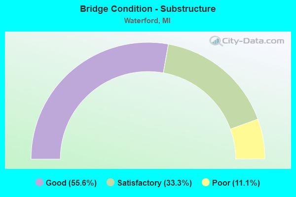
- Bridge Condition - Substructure
- 55.6%Good
- 33.3%Satisfactory
- 11.1%Poor
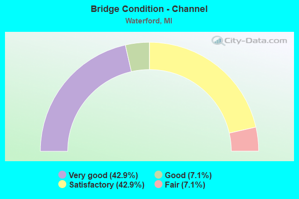
- Bridge Condition - Channel
- 42.9%Very good
- 7.1%Good
- 42.9%Satisfactory
- 7.1%Fair
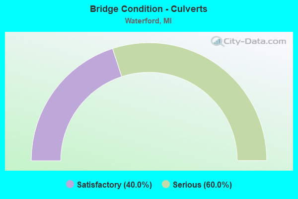
- Bridge Condition - Culverts
- 40.0%Satisfactory
- 60.0%Serious
Find on map >> Show street view
Structure Number: 7816, Location: 4.0 MI W OF PONTIAC (Lat: 42.660314, Lng: -83.390222), Route carried "on" structure: State highway 59, Year Built: 1965, Status: Open, Structure Length: 1.22m (4.00ft), Average Daily Traffic: 37,281 (year 2007), Truck Traffic: 4%, Average Future Daily Traffic: 43,399 (year 2018), Design Load: HS 20, Features Intersected: CLINTON RIVER
Minimum Vertical Clearance: 30.48m (100.00ft), Kilometerpoint: 24.701, Lanes on structure: 5, Base Highway Network: Yes (Inventory Route: 64, Subroute: 6), Owner: State Highway Agency, Approaching Roadway Width: 19.2m (63.0ft), Material/Design: Prestressed concrete, Design/Construction: Stringer/Multi-beam, Number Of Spans In Main Unit: 1, Length of Maximum Span: 12.2m (40.0ft), Curb or Sidewalk Widths: Left: 0.9m (3.0ft), Right: 0.9m (3.0ft), Curb-To-Curb Width: 19.2m (63.0ft), Out-to-Out Width: 21.7m (71.2ft)
Condition: Deck: Good, Superstructure: Very good, Substructure: Good, Channel: Satisfactory, Operating Rating: 44.4 metric tons, Method Used To Determine Operating Rating: Load Factor (LF) rating reported by rating factor (RF) method using MS18 loading, Inventory Rating: 26.6 metric tons, Method Used To Determine Inventory Rating: Load Factor (LF) rating reported by rating factor (RF) method using MS18 loading, Structural Evaluation: Equal to present minimum criteria, Deck Geometry: Meets minimum limits, Waterway Adequacy: Equal to present desirable criteria, Approach Roadway Alignment: Equal to present minimum criteria, Designated Inspection Frequency: Every 24 months, Inspection Date: May 2021, Deck Structure Type: Concrete Cast-file-Place, Wearing Surface/Protective System: Wearing Surface: Latex Concrete
Find on map >> Show street view
Structure Number: 7866, Location: 3.6 MI SE OF M-15 (Lat: 42.680381, Lng: -83.372225), Route carried "on" structure: US 24, Year Built: 2012, Status: Open, Structure Length: 1.23m (4.04ft), Average Daily Traffic: 36,241 (year 2007), Truck Traffic: 3%, Average Future Daily Traffic: 47,800 (year 2030), Design Load: Greater than HL93, Features Intersected: CLINTON R
Minimum Vertical Clearance: 30.48m (100.00ft), Kilometerpoint: 9.906, Lanes on structure: 5, Base Highway Network: Yes (Inventory Route: 68, Subroute: 3), Owner: State Highway Agency, Approaching Roadway Width: 19.5m (64.0ft), Material/Design: Prestressed concrete, Design/Construction: Box Beam or Girders - Single/Spread, Number Of Spans In Main Unit: 1, Length of Maximum Span: 11.4m (37.4ft), Curb or Sidewalk Widths: Left: 2.7m (8.9ft), Right: 2.7m (8.9ft), Curb-To-Curb Width: 19.5m (64.0ft), Out-to-Out Width: 25.6m (84.0ft)
Condition: Deck: Very good, Superstructure: Very good, Substructure: Good, Channel: Very good, Operating Rating: 62.5 metric tons, Method Used To Determine Operating Rating: Load and Resistance Factor Rating (LRFR) rating reported by rating factor(RF) method using HL-93 loadings, Inventory Rating: 45.7 metric tons, Method Used To Determine Inventory Rating: Load and Resistance Factor Rating (LRFR) rating reported by rating factor(RF) method using HL-93 loadings, Structural Evaluation: Better than present minimum criteria, Deck Geometry: Meets minimum limits, Waterway Adequacy: Equal to present desirable criteria, Approach Roadway Alignment: Equal to present desirable criteria, Designated Inspection Frequency: Every 24 months, Inspection Date: May 2021, Deck Structure Type: Concrete Cast-file-Place, Wearing Surface/Protective System: Wearing Surface: Monolithic Concrete, Deck Protection: Epoxy Coated Reinforcing
Find on map >> Show street view
Structure Number: 7867, Location: 1.5MI SE OF M-15 (Lat: 42.703167, Lng: -83.403683), Route carried "on" structure: US 24, Year Built: 1929, Year Reconstructed: 1989, Status: Open, Structure Length: 1.22m (4.00ft), Average Daily Traffic: 36,241 (year 2007), Truck Traffic: 4%, Average Future Daily Traffic: 36,564 (year 2018), Design Load: H 15, Features Intersected: CLINTON R
Minimum Vertical Clearance: 30.48m (100.00ft), Kilometerpoint: 6.372, Lanes on structure: 5, Base Highway Network: Yes (Inventory Route: 68, Subroute: 3), Owner: State Highway Agency, Approaching Roadway Width: 18.9m (62.0ft), Material/Design: Prestressed concrete, Design/Construction: Stringer/Multi-beam, Number Of Spans In Main Unit: 1, Length of Maximum Span: 12.2m (40.0ft), Curb or Sidewalk Widths: Left: 2.9m (9.5ft), Right: 2.5m (8.2ft), Curb-To-Curb Width: 19.5m (64.0ft), Out-to-Out Width: 25.4m (83.3ft)
Condition: Deck: Good, Superstructure: Very good, Substructure: Satisfactory, Channel: Very good, Operating Rating: 56.1 metric tons, Method Used To Determine Operating Rating: Load Factor (LF) rating reported by rating factor (RF) method using MS18 loading, Inventory Rating: 33.4 metric tons, Method Used To Determine Inventory Rating: Load Factor (LF) rating reported by rating factor (RF) method using MS18 loading, Structural Evaluation: Equal to present minimum criteria, Deck Geometry: Meets minimum limits, Waterway Adequacy: Equal to present desirable criteria, Approach Roadway Alignment: Equal to present desirable criteria, Designated Inspection Frequency: Every 24 months, Inspection Date: May 2021, Deck Structure Type: Concrete Cast-file-Place, Wearing Surface/Protective System: Wearing Surface: Latex Concrete
Find on map >> Show street view
Structure Number: 8179, Location: BET CASS ELIZABETH & HILL (Lat: 42.627717, Lng: -83.394842), Route carried "on" structure: County highway 2059, Year Built: 1994, Status: Open, Structure Length: 1.46m (4.79ft), Average Daily Traffic: 19,500 (year 2015), Truck Traffic: 5%, Average Future Daily Traffic: 19,750 (year 2035), Design Load: HS 20+Mod, Features Intersected: CLINTON RIVER, Facility Carried by Structure: COOLEY LAKE ROAD
Minimum Vertical Clearance: 30.48m (100.00ft), Kilometerpoint: 4.843, Lanes on structure: 4, Base Highway Network: Yes (Inventory Route: 63, Subroute: 3), Owner: County Highway Agency, Approaching Roadway Width: 11.9m (39.0ft), Material/Design: Prestressed concrete, Design/Construction: Box Beam or Girders - Multiple, Number Of Spans In Main Unit: 1, Length of Maximum Span: 13.4m (44.0ft), Curb or Sidewalk Widths: Left: 1.7m (5.6ft), Right: 0.0m, Curb-To-Curb Width: 20.7m (67.9ft), Out-to-Out Width: 23.5m (77.1ft)
Condition: Deck: Good, Superstructure: Good, Substructure: Satisfactory, Channel: Good, Operating Rating: 69.4 metric tons, Method Used To Determine Operating Rating: Load Factor (LF), Inventory Rating: 41.6 metric tons, Method Used To Determine Inventory Rating: Load Factor (LF), Structural Evaluation: Equal to present minimum criteria, Deck Geometry: Superior to present desirable criteria, Waterway Adequacy: Equal to present desirable criteria, Approach Roadway Alignment: Somewhat better than minimum adequacy, Designated Inspection Frequency: Every 24 months, Inspection Date: July 2020, Deck Structure Type: Concrete Cast-file-Place, Wearing Surface/Protective System: Wearing Surface: Monolithic Concrete, Deck Protection: Epoxy Coated Reinforcing
Find on map >> Show street view
Structure Number: 818, Location: BET AIRPORT AND CRESCENT (Lat: 42.645267, Lng: -83.403303), Route carried "on" structure: County highway 2059, Year Built: 1986, Status: Open, Structure Length: 1.28m (4.20ft), Average Daily Traffic: 8,250 (year 2015), Average Future Daily Traffic: 8,500 (year 2035), Design Load: HS 20+Mod, Features Intersected: CLINTON RIVER, Facility Carried by Structure: ELIZABETH LAKE RD
Minimum Vertical Clearance: 30.48m (100.00ft), Kilometerpoint: 3.293, Lanes on structure: 2, Owner: County Highway Agency, Approaching Roadway Width: 8.5m (27.9ft), Material/Design: Prestressed concrete, Design/Construction: Box Beam or Girders - Multiple, Number Of Spans In Main Unit: 1, Length of Maximum Span: 12.2m (40.0ft), Curb-To-Curb Width: 12.2m (40.0ft), Out-to-Out Width: 13.3m (43.6ft)
Condition: Deck: Satisfactory, Superstructure: Good, Substructure: Good, Channel: Satisfactory, Operating Rating: 64.2 metric tons, Method Used To Determine Operating Rating: Load Factor (LF) rating reported by rating factor (RF) method using MS18 loading, Inventory Rating: 38.6 metric tons, Method Used To Determine Inventory Rating: Load Factor (LF) rating reported by rating factor (RF) method using MS18 loading, Structural Evaluation: Better than present minimum criteria, Deck Geometry: Somewhat better than minimum adequacy, Waterway Adequacy: Equal to present minimum criteria, Approach Roadway Alignment: Equal to present desirable criteria, Designated Inspection Frequency: Every 24 months, Inspection Date: July 2020, Deck Structure Type: Concrete Cast-file-Place, Wearing Surface/Protective System: Wearing Surface: Monolithic Concrete, Membrane: Preformed Fabric, Deck Protection: Epoxy Coated Reinforcing
Find on map >> Show street view
Structure Number: 8183, Location: BET FREMBES AND DIXIE (Lat: 42.675478, Lng: -83.375942), Route carried "on" structure: County highway 2059, Year Built: 1962, Status: Posted for load, Structure Length: 1.22m (4.00ft), Average Daily Traffic: 9,200 (year 2016), Average Future Daily Traffic: 12,400 (year 2036), Design Load: HS 20+Mod, Features Intersected: CLINTON RIVER, Facility Carried by Structure: HATCHERY ROAD
Minimum Vertical Clearance: 30.48m (100.00ft), Kilometerpoint: 5.514, Lanes on structure: 2, Owner: County Highway Agency, Approaching Roadway Width: 10.9m (35.8ft), Skew: 2 degrees, Material/Design: Prestressed concrete, Design/Construction: Box Beam or Girders - Multiple, Number Of Spans In Main Unit: 1, Length of Maximum Span: 10.6m (34.8ft), Curb or Sidewalk Widths: Left: 0.6m (2.0ft), Right: 0.6m (2.0ft), Curb-To-Curb Width: 9.2m (30.2ft), Out-to-Out Width: 11.1m (36.4ft)
Condition: Deck: Serious, Superstructure: Serious, Substructure: Poor, Channel: Very good, Operating Rating: 38.6 metric tons, Method Used To Determine Operating Rating: Load Factor (LF) rating reported by rating factor (RF) method using MS18 loading, Inventory Rating: 23.0 metric tons, Method Used To Determine Inventory Rating: Load Factor (LF) rating reported by rating factor (RF) method using MS18 loading, Structural Evaluation: High priority of corrective action, Deck Geometry: High priority of corrective action, Waterway Adequacy: Equal to present desirable criteria, Approach Roadway Alignment: Meets minimum limits, Bridge Posting: Required (Relationship of Operating Rating to Maximum Legal Load: 20.0 - 29.9% below), Length Of Structure Improvement: 1.22m (4.00ft), Designated Inspection Frequency: Every 12 months, Inspection Date: March 2021, Bridge Improvement Cost: $15,000, Roadway Improvement Cost: $2,000, Total Project Cost: $18,000 ( Estimate for 2050), Deck Structure Type: Concrete Cast-file-Place, Wearing Surface/Protective System: Wearing Surface: Bituminous
Find on map >> Show street view
Structure Number: 8187, Location: BET SASHABAW AND CLINTONV (Lat: 42.688417, Lng: -83.351919), Route carried "on" structure: County highway 2059, Year Built: 1992, Status: Open, Structure Length: 1.12m (3.67ft), Average Daily Traffic: 15,000 (year 2015), Average Future Daily Traffic: 15,250 (year 2035), Design Load: HS 20, Features Intersected: CLINTON RIVER, Facility Carried by Structure: WALTON BLVD
Minimum Vertical Clearance: 30.48m (100.00ft), Kilometerpoint: 2.781, Lanes on structure: 5, Base Highway Network: Yes (Inventory Route: 69, Subroute: 9), Owner: County Highway Agency, Approaching Roadway Width: 8.5m (27.9ft), Material/Design: Prestressed concrete, Design/Construction: Box Beam or Girders - Multiple, Number Of Spans In Main Unit: 1, Length of Maximum Span: 10.0m (32.8ft), Curb-To-Curb Width: 20.9m (68.6ft), Out-to-Out Width: 21.9m (71.9ft)
Condition: Deck: Good, Superstructure: Satisfactory, Substructure: Satisfactory, Channel: Satisfactory, Inventory Rating: 78.7 metric tons, Method Used To Determine Inventory Rating: Load Factor (LF), Structural Evaluation: Equal to present minimum criteria, Deck Geometry: Somewhat better than minimum adequacy, Waterway Adequacy: Superior to present desirable criteria, Approach Roadway Alignment: Equal to present desirable criteria, Designated Inspection Frequency: Every 24 months, Inspection Date: July 2020, Deck Structure Type: Concrete Cast-file-Place, Wearing Surface/Protective System: Wearing Surface: Monolithic Concrete, Deck Protection: Epoxy Coated Reinforcing
Find on map >> Show street view
Structure Number: 8212, Location: N OF HATCHERY RD (Lat: 42.675336, Lng: -83.416744), Route carried "on" structure: County highway , Year Built: 1990, Status: Open, Structure Length: 0.76m (2.49ft), Average Daily Traffic: 1,200 (year 2016), Truck Traffic: 5%, Average Future Daily Traffic: 1,325 (year 2036), Design Load: HS 20+Mod, Features Intersected: WILLIAMS LAKE CANAL, Facility Carried by Structure: LANSDOWNE RD
Minimum Vertical Clearance: 30.48m (100.00ft), Kilometerpoint: 0.150, Lanes on structure: 2, Owner: County Highway Agency, Approaching Roadway Width: 10.3m (33.8ft), Material/Design: Prestressed concrete, Design/Construction: Box Beam or Girders - Multiple, Number Of Spans In Main Unit: 1, Length of Maximum Span: 7.3m (24.0ft), Curb-To-Curb Width: 10.4m (34.1ft), Out-to-Out Width: 11.4m (37.4ft)
Condition: Deck: Satisfactory, Superstructure: Fair, Substructure: Good, Channel: Very good, Operating Rating: 49.2 metric tons, Method Used To Determine Operating Rating: Load Factor (LF) rating reported by rating factor (RF) method using MS18 loading, Inventory Rating: 29.5 metric tons, Method Used To Determine Inventory Rating: Load Factor (LF) rating reported by rating factor (RF) method using MS18 loading, Structural Evaluation: Somewhat better than minimum adequacy, Deck Geometry: Equal to present minimum criteria, Waterway Adequacy: Superior to present desirable criteria, Approach Roadway Alignment: Equal to present desirable criteria, Designated Inspection Frequency: Every 24 months, Inspection Date: July 2020, Deck Structure Type: Concrete Precast Panels, Wearing Surface/Protective System: Wearing Surface: Bituminous, Membrane: Preformed Fabric
Find on map >> Show street view
Structure Number: 12725, Location: 0.5 MI NE OF CASS LAKE RD (Lat: 42.623297, Lng: -83.345225), Route carried "on" structure: County highway , Year Built: 1997, Status: Open, Structure Length: 1.95m (6.40ft), Average Daily Traffic: 120 (year 1997), Truck Traffic: 5%, Average Future Daily Traffic: 312 (year 2017), Design Load: HS 20, Features Intersected: OTTER SYLVAN LAKE CANAL, Facility Carried by Structure: BEACHLAND BLVD
Minimum Vertical Clearance: 30.48m (100.00ft), Kilometerpoint: 0.832, Lanes on structure: 2, Owner: County Highway Agency, Approaching Roadway Width: 9.1m (29.9ft), Skew: 1 degrees, Material/Design: Prestressed concrete, Design/Construction: Box Beam or Girders - Multiple, Number Of Spans In Main Unit: 1, Length of Maximum Span: 19.1m (62.7ft), Curb-To-Curb Width: 9.8m (32.2ft), Out-to-Out Width: 10.4m (34.1ft)
Condition: Deck: Satisfactory, Superstructure: Satisfactory, Substructure: Good, Channel: Very good, Operating Rating: 70.0 metric tons, Method Used To Determine Operating Rating: Load Factor (LF) rating reported by rating factor (RF) method using MS18 loading, Inventory Rating: 41.8 metric tons, Method Used To Determine Inventory Rating: Load Factor (LF) rating reported by rating factor (RF) method using MS18 loading, Structural Evaluation: Equal to present minimum criteria, Deck Geometry: Better than present minimum criteria, Waterway Adequacy: Superior to present desirable criteria, Approach Roadway Alignment: Equal to present desirable criteria, Designated Inspection Frequency: Every 24 months, Inspection Date: July 2020, Deck Structure Type: Concrete Precast Panels, Wearing Surface/Protective System: Wearing Surface: Bituminous
Find on map >> Show street view
Structure Number: 1317, Location: SOUTH OF WALTON BLVD (Lat: 42.678253, Lng: -83.334036), Route carried "on" structure: County highway , Year Built: 2003, Status: Open, Structure Length: 0.61m (2.00ft), Average Daily Traffic: 11,583 (year 2003), Truck Traffic: 3%, Average Future Daily Traffic: 13,900 (year 2023), Design Load: HS 20, Features Intersected: SILVER LAKE CANAL, Facility Carried by Structure: SILVER LAKE RD
Minimum Vertical Clearance: 30.48m (100.00ft), Kilometerpoint: 0.840, Lanes on structure: 2, Owner: County Highway Agency, Approaching Roadway Width: 10.4m (34.1ft), Skew: 8 degrees, Material/Design: Concrete, Design/Construction: Culvert, Number Of Spans In Main Unit: 1, Length of Maximum Span: 6.1m (20.0ft), Curb-To-Curb Width: 13.9m (45.6ft), Out-to-Out Width: 18.1m (59.4ft)
Condition: Channel: Very good, Culverts: Satisfactory, Operating Rating: 54.5 metric tons, Method Used To Determine Operating Rating: Field evaluation and documented engineering judgment, Inventory Rating: 32.7 metric tons, Method Used To Determine Inventory Rating: Field evaluation and documented engineering judgment, Structural Evaluation: Equal to present minimum criteria, Deck Geometry: Superior to present desirable criteria, Waterway Adequacy: Equal to present minimum criteria, Approach Roadway Alignment: Equal to present desirable criteria, Designated Inspection Frequency: Every 24 months, Inspection Date: July 2020, Wearing Surface/Protective System: Wearing Surface: Bituminous
Find on map >> Show street view
Structure Number: 13808, Location: WATERFORD TWP SEC 11 (Lat: 42.688000, Lng: -83.356400), Route carried "on" structure: County highway , Year Built: 1995, Status: Open, Structure Length: 0.95m (3.12ft), Average Daily Traffic: 20 (year 2012), Average Future Daily Traffic: 24 (year 2032), Design Load: HS 20, Features Intersected: CLINTON RIVER, Facility Carried by Structure: INDIAN VIEW DRIVE
Minimum Vertical Clearance: 30.48m (100.00ft), Kilometerpoint: 0.422, Lanes on structure: 2, Owner: County Highway Agency, Approaching Roadway Width: 9.0m (29.5ft), Material/Design: Steel, Design/Construction: Culvert, Number Of Spans In Main Unit: 2, Length of Maximum Span: 3.9m (12.8ft), Curb-To-Curb Width: 8.9m (29.2ft), Out-to-Out Width: 9.1m (29.9ft)
Condition: Channel: Satisfactory, Culverts: Satisfactory, Operating Rating: 34.3 metric tons, Method Used To Determine Operating Rating: Load Factor (LF) rating reported by rating factor (RF) method using MS18 loading, Inventory Rating: 27.5 metric tons, Method Used To Determine Inventory Rating: Load Factor (LF) rating reported by rating factor (RF) method using MS18 loading, Structural Evaluation: Equal to present minimum criteria, Deck Geometry: Better than present minimum criteria, Waterway Adequacy: Equal to present minimum criteria, Approach Roadway Alignment: Equal to present minimum criteria, Designated Inspection Frequency: Every 24 months, Inspection Date: July 2020, Wearing Surface/Protective System: Wearing Surface: Bituminous
Find on map >> Show street view
Structure Number: 1381, Location: WATERFORD TWP SEC 21 (Lat: 42.652800, Lng: -83.397500), Route carried "on" structure: County highway , Year Built: 1985, Status: Posted for load, Structure Length: 1.07m (3.51ft), Average Daily Traffic: 8,800 (year 2021), Average Future Daily Traffic: 11,900 (year 2041), Design Load: HS 20, Features Intersected: CLINTON RIVER, Facility Carried by Structure: PONTIAC LAKE ROAD
Minimum Vertical Clearance: 30.48m (100.00ft), Kilometerpoint: 10.830, Lanes on structure: 2, Owner: County Highway Agency, Approaching Roadway Width: 8.2m (26.9ft), Material/Design: Steel, Design/Construction: Culvert, Number Of Spans In Main Unit: 3, Length of Maximum Span: 3.0m (9.8ft), Curb-To-Curb Width: 8.4m (27.6ft), Out-to-Out Width: 9.5m (31.2ft)
Condition: Channel: Fair, Culverts: Serious, Operating Rating: 16.8 metric tons, Method Used To Determine Operating Rating: Load Factor (LF) rating reported by rating factor (RF) method using MS18 loading, Inventory Rating: 10.0 metric tons, Method Used To Determine Inventory Rating: Load Factor (LF) rating reported by rating factor (RF) method using MS18 loading, Structural Evaluation: High priority of corrective action, Deck Geometry: High priority of replacement, Waterway Adequacy: Equal to present minimum criteria, Approach Roadway Alignment: Better than present minimum criteria, Bridge Posting: Required (Relationship of Operating Rating to Maximum Legal Load: 30.0 - 39.9% below), Designated Inspection Frequency: Every 12 months, Inspection Date: July 2021, Wearing Surface/Protective System: Wearing Surface: Bituminous
Find on map >> Show street view
Structure Number: 14038, Location: 0.25 MI S OF M-59 (Lat: 42.654750, Lng: -83.396389), Route carried "on" structure: County highway , Year Built: 1956, Status: Posted for load, Structure Length: 0.79m (2.59ft), Average Daily Traffic: 200 (year 2017), Average Future Daily Traffic: 328 (year 2042), Design Load: HS 20, Features Intersected: CLINTON RIVER, Facility Carried by Structure: EDGEORGE STREET
Minimum Vertical Clearance: 30.48m (100.00ft), Kilometerpoint: 0.201, Lanes on structure: 2, Owner: County Highway Agency, Approaching Roadway Width: 6.9m (22.6ft), Material/Design: Steel, Design/Construction: Culvert, Number Of Spans In Main Unit: 2, Length of Maximum Span: 3.7m (12.1ft), Curb-To-Curb Width: 6.9m (22.6ft), Out-to-Out Width: 15.8m (51.8ft)
Condition: Channel: Satisfactory, Culverts: Serious, Operating Rating: 14.9 metric tons, Method Used To Determine Operating Rating: Load Factor (LF) rating reported by rating factor (RF) method using MS18 loading, Inventory Rating: 9.1 metric tons, Method Used To Determine Inventory Rating: Load Factor (LF) rating reported by rating factor (RF) method using MS18 loading, Structural Evaluation: High priority of corrective action, Deck Geometry: Meets minimum limits, Waterway Adequacy: Somewhat better than minimum adequacy, Approach Roadway Alignment: Meets minimum limits, Bridge Posting: Required (Relationship of Operating Rating to Maximum Legal Load: > 39.9% below), Designated Inspection Frequency: Every 12 months, Inspection Date: October 2021, Wearing Surface/Protective System: Wearing Surface: Bituminous
Find on map >> Show street view
Structure Number: 14039, Location: 0.25 MI S OF M-59 (Lat: 42.655528, Lng: -83.393250), Route carried "on" structure: County highway , Year Built: 1959, Status: Posted for load, Structure Length: 0.85m (2.79ft), Average Daily Traffic: 200 (year 2017), Average Future Daily Traffic: 328 (year 2042), Design Load: HS 20, Features Intersected: CLINTON RIVER, Facility Carried by Structure: EMBURKE BLVD
Minimum Vertical Clearance: 30.48m (100.00ft), Kilometerpoint: 0.081, Lanes on structure: 2, Owner: County Highway Agency, Approaching Roadway Width: 6.7m (22.0ft), Material/Design: Steel, Design/Construction: Culvert, Number Of Spans In Main Unit: 2, Length of Maximum Span: 3.5m (11.5ft), Curb-To-Curb Width: 9.3m (30.5ft), Out-to-Out Width: 15.7m (51.5ft)
Condition: Channel: Satisfactory, Culverts: Serious, Operating Rating: 14.9 metric tons, Method Used To Determine Operating Rating: Load Factor (LF) rating reported by rating factor (RF) method using MS18 loading, Inventory Rating: 9.1 metric tons, Method Used To Determine Inventory Rating: Load Factor (LF) rating reported by rating factor (RF) method using MS18 loading, Structural Evaluation: High priority of corrective action, Deck Geometry: Equal to present minimum criteria, Waterway Adequacy: Better than present minimum criteria, Approach Roadway Alignment: Somewhat better than minimum adequacy, Bridge Posting: Required (Relationship of Operating Rating to Maximum Legal Load: > 39.9% below), Designated Inspection Frequency: Every 12 months, Inspection Date: October 2021, Wearing Surface/Protective System: Wearing Surface: Bituminous
Find on map >> Show street view
Structure Number: 7822, Location: 0.5 MI W INTER US-24 (Lat: 42.634858, Lng: -83.336739), Route carried "under" structure: State highway 59, Year Built: 1975, Structure Length: 0. m, Average Daily Traffic: 24,619 (year 2007), Truck Traffic: 4%, Features Intersected: M-59 HURON, Facility Carried by Structure: PED O PASS
Minimum Vertical Clearance: 5.11m (16.77ft), Kilometerpoint: 30.085, Lanes under structure: 4, Material/Design: Steel, Design/Construction: Girder and Floorbeam System, Length of Maximum Span: 25.6m (84.0ft)