Bridge Statistics for Warrington, Florida (FL)
Condition, Traffic, Stress, Structural Evaluation, Project Costs
- National Bridge Inventory (NBI) Statistics
- 12Number of bridges
- 167ft / 50.8mTotal length
- 93,350Total average daily traffic
- 4,369Total average daily truck traffic
- 161,964Total future (year 2040) average daily traffic
- National Bridge Inventory (NBI) Registered Bridges for Warrington
- No street view available for this location
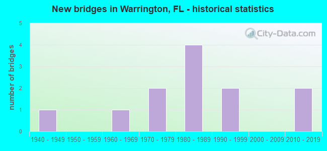
- New bridges - historical statistics
- 11940-1949
- 11960-1969
- 21970-1979
- 41980-1989
- 21990-1999
- 22010-2019


- Bridge Condition - Deck
- 12.5%Very good
- 25.0%Good
- 50.0%Satisfactory
- 12.5%Fair

- Bridge Condition - Superstructure
- 12.5%Very good
- 25.0%Good
- 50.0%Satisfactory
- 12.5%Fair

- Bridge Condition - Substructure
- 37.5%Good
- 62.5%Satisfactory

- Bridge Condition - Channel
- 16.7%Excellent
- 25.0%Very good
- 16.7%Good
- 33.3%Satisfactory
- 8.3%Fair

- Bridge Condition - Culverts
- 25.0%Very good
- 50.0%Satisfactory
- 25.0%Fair
Find on map >> Show street view
Structure Number: 480029, Location: INT. of SR295 & US98 SR30 (Lat: 30.398056, Lng: -87.277583), Route carried "on" structure: State highway 295, Year Built: 1970, Status: Open, Structure Length: 0.98m (3.22ft), Average Daily Traffic: 26,000 (year 2020), Truck Traffic: 3%, Average Future Daily Traffic: 45,110 (year 2042), Design Load: HS 20, Features Intersected: Jones Swamp
Minimum Vertical Clearance: 30+ m (98+ ft), Kilometerpoint: 2.673, Lanes on structure: 6, Base Highway Network: Yes, Owner: State Highway Agency, Approaching Roadway Width: 19.2m (63.0ft), Skew: 11 degrees, Material/Design: Concrete, Design/Construction: Culvert, Number Of Spans In Main Unit: 3, Length of Maximum Span: 3.1m (10.2ft)
Condition: Channel: Satisfactory, Culverts: Satisfactory, Operating Rating: 50.8 metric tons, Method Used To Determine Operating Rating: Load Factor (LF), Inventory Rating: 29.9 metric tons, Method Used To Determine Inventory Rating: Load Factor (LF), Structural Evaluation: Equal to present minimum criteria, Waterway Adequacy: Equal to present minimum criteria, Approach Roadway Alignment: Equal to present desirable criteria, Designated Inspection Frequency: Every 24 months, Inspection Date: June 2020
Find on map >> Show street view
Structure Number: 480036, Location: 0.7MI East of SR173 (Lat: 30.364111, Lng: -87.346811), Route carried "on" structure: State highway 292, Year Built: 1964, Status: Open, Structure Length: 0.64m (2.10ft), Average Daily Traffic: 11,200 (year 2020), Truck Traffic: 5%, Average Future Daily Traffic: 19,432 (year 2040), Design Load: HS 20, Features Intersected: Jones Swamp
Minimum Vertical Clearance: 30+ m (98+ ft), Kilometerpoint: 20.577, Lanes on structure: 2, Base Highway Network: Yes, Owner: State Highway Agency, Approaching Roadway Width: 7.0m (23.0ft), Skew: 1 degrees, Material/Design: Concrete, Design/Construction: Culvert, Number Of Spans In Main Unit: 2, Length of Maximum Span: 3.1m (10.2ft)
Condition: Channel: Satisfactory, Culverts: Satisfactory, Operating Rating: 49.9 metric tons, Method Used To Determine Operating Rating: Load Factor (LF), Inventory Rating: 29.9 metric tons, Method Used To Determine Inventory Rating: Load Factor (LF), Structural Evaluation: Equal to present minimum criteria, Waterway Adequacy: Equal to present desirable criteria, Approach Roadway Alignment: Equal to present desirable criteria, Designated Inspection Frequency: Every 24 months, Underwater Inspection Frequency: Every 24 months, Inspection Date: June 2021, Underwater Inspection Date: June 2021
Find on map >> Show street view
Structure Number: 480132, Location: 1.4 Mi South of US 98 (Lat: 30.388325, Lng: -87.359319), Route carried "on" structure: County highway 297, Year Built: 1944, Status: Open, Structure Length: 0.95m (3.12ft), Average Daily Traffic: 6,300 (year 2020), Truck Traffic: 9%, Average Future Daily Traffic: 10,931 (year 2042), Features Intersected: Unnamed Stream
Minimum Vertical Clearance: 30+ m (98+ ft), Kilometerpoint: 3.034, Lanes on structure: 2, Owner: County Highway Agency, Approaching Roadway Width: 6.7m (22.0ft), Material/Design: Concrete, Design/Construction: Culvert, Number Of Spans In Main Unit: 3, Length of Maximum Span: 3.3m (10.8ft), Curb or Sidewalk Widths: Left: 2.1m (6.9ft), Right: 2.3m (7.5ft)
Condition: Channel: Fair, Culverts: Fair, Operating Rating: 52.5 metric tons, Method Used To Determine Operating Rating: Load Factor (LF), Inventory Rating: 31.5 metric tons, Method Used To Determine Inventory Rating: Load Factor (LF), Structural Evaluation: Somewhat better than minimum adequacy, Waterway Adequacy: Better than present minimum criteria, Approach Roadway Alignment: Equal to present desirable criteria, Designated Inspection Frequency: Every 24 months, Inspection Date: May 2021
Find on map >> Show street view
Structure Number: 480171, Location: 1.1Mi. South of SR292 (Lat: 30.345694, Lng: -87.351172), Route carried "on" structure: State highway 173, Year Built: 1980, Status: Open, Structure Length: 4.57m (14.99ft), Average Daily Traffic: 5,050 (year 2020), Truck Traffic: 6%, Average Future Daily Traffic: 8,762 (year 2042), Design Load: HS 20, Features Intersected: Garcon Swamp
Minimum Vertical Clearance: 30+ m (98+ ft), Kilometerpoint: 1.936, Lanes on structure: 2, Base Highway Network: Yes, Owner: State Highway Agency, Approaching Roadway Width: 8.5m (27.9ft), Material/Design: Concrete continuous, Design/Construction: Slab, Number Of Spans In Main Unit: 5, Length of Maximum Span: 9.1m (29.9ft), Curb-To-Curb Width: 12.2m (40.0ft), Out-to-Out Width: 13.0m (42.7ft)
Condition: Deck: Satisfactory, Superstructure: Satisfactory, Substructure: Satisfactory, Channel: Very good, Operating Rating: 65.3 metric tons, Method Used To Determine Operating Rating: Load Factor (LF), Inventory Rating: 39.0 metric tons, Method Used To Determine Inventory Rating: Load Factor (LF), Structural Evaluation: Equal to present minimum criteria, Deck Geometry: Better than present minimum criteria, Waterway Adequacy: Equal to present desirable criteria, Approach Roadway Alignment: Equal to present desirable criteria, Designated Inspection Frequency: Every 24 months, Inspection Date: May 2020, Deck Structure Type: Concrete Cast-file-Place
Find on map >> Show street view
Structure Number: 480172, Location: 1.1 Mi. South of SR292 (Lat: 30.345778, Lng: -87.350983), Route carried "on" structure: State highway 173, Year Built: 1980, Status: Open, Structure Length: 4.57m (14.99ft), Average Daily Traffic: 5,050 (year 2020), Truck Traffic: 6%, Average Future Daily Traffic: 8,762 (year 2042), Design Load: HS 20, Features Intersected: Garcon Swamp
Minimum Vertical Clearance: 30+ m (98+ ft), Kilometerpoint: 1.936, Lanes on structure: 2, Base Highway Network: Yes, Owner: State Highway Agency, Approaching Roadway Width: 8.5m (27.9ft), Material/Design: Concrete continuous, Design/Construction: Slab, Number Of Spans In Main Unit: 5, Length of Maximum Span: 9.1m (29.9ft), Curb-To-Curb Width: 12.2m (40.0ft), Out-to-Out Width: 13.0m (42.7ft)
Condition: Deck: Satisfactory, Superstructure: Satisfactory, Substructure: Satisfactory, Channel: Very good, Operating Rating: 65.3 metric tons, Method Used To Determine Operating Rating: Load Factor (LF), Inventory Rating: 39.0 metric tons, Method Used To Determine Inventory Rating: Load Factor (LF), Structural Evaluation: Equal to present minimum criteria, Deck Geometry: Better than present minimum criteria, Waterway Adequacy: Equal to present desirable criteria, Approach Roadway Alignment: Equal to present desirable criteria, Designated Inspection Frequency: Every 24 months, Inspection Date: May 2020, Deck Structure Type: Concrete Cast-file-Place
Find on map >> Show street view
Structure Number: 480173, Location: 0.2 Mi. South of SR292 (Lat: 30.357450, Lng: -87.357283), Route carried "on" structure: State highway 173, Year Built: 1980, Status: Open, Structure Length: 4.57m (14.99ft), Average Daily Traffic: 5,050 (year 2020), Truck Traffic: 6%, Average Future Daily Traffic: 8,762 (year 2042), Design Load: HS 20, Features Intersected: Bayou Grande
Minimum Vertical Clearance: 30+ m (98+ ft), Kilometerpoint: 3.370, Lanes on structure: 2, Base Highway Network: Yes, Owner: State Highway Agency, Approaching Roadway Width: 8.5m (27.9ft), Material/Design: Concrete continuous, Design/Construction: Slab, Number Of Spans In Main Unit: 5, Length of Maximum Span: 9.1m (29.9ft), Curb-To-Curb Width: 12.2m (40.0ft), Out-to-Out Width: 13.0m (42.7ft)
Condition: Deck: Good, Superstructure: Good, Substructure: Satisfactory, Channel: Good, Operating Rating: 65.3 metric tons, Method Used To Determine Operating Rating: Load Factor (LF), Inventory Rating: 39.0 metric tons, Method Used To Determine Inventory Rating: Load Factor (LF), Structural Evaluation: Equal to present minimum criteria, Deck Geometry: Better than present minimum criteria, Waterway Adequacy: Equal to present desirable criteria, Approach Roadway Alignment: Equal to present desirable criteria, Designated Inspection Frequency: Every 24 months, Inspection Date: May 2020, Deck Structure Type: Concrete Cast-file-Place
Find on map >> Show street view
Structure Number: 480174, Location: 0.2MI. South of SR292 (Lat: 30.357536, Lng: -87.357086), Route carried "on" structure: State highway 173, Year Built: 1980, Status: Open, Structure Length: 4.57m (14.99ft), Average Daily Traffic: 5,050 (year 2020), Truck Traffic: 6%, Average Future Daily Traffic: 8,762 (year 2042), Design Load: HS 20, Features Intersected: Bayou Grande
Minimum Vertical Clearance: 30+ m (98+ ft), Kilometerpoint: 3.370, Lanes on structure: 2, Base Highway Network: Yes, Owner: State Highway Agency, Approaching Roadway Width: 8.5m (27.9ft), Material/Design: Concrete continuous, Design/Construction: Slab, Number Of Spans In Main Unit: 5, Length of Maximum Span: 9.1m (29.9ft), Curb-To-Curb Width: 12.2m (40.0ft), Out-to-Out Width: 13.0m (42.7ft)
Condition: Deck: Satisfactory, Superstructure: Satisfactory, Substructure: Satisfactory, Channel: Good, Operating Rating: 65.3 metric tons, Method Used To Determine Operating Rating: Load Factor (LF), Inventory Rating: 39.0 metric tons, Method Used To Determine Inventory Rating: Load Factor (LF), Structural Evaluation: Equal to present minimum criteria, Deck Geometry: Better than present minimum criteria, Waterway Adequacy: Equal to present desirable criteria, Approach Roadway Alignment: Equal to present desirable criteria, Designated Inspection Frequency: Every 24 months, Inspection Date: May 2020, Deck Structure Type: Concrete Cast-file-Place
Find on map >> Show street view
Structure Number: 480181, Location: 2.4 Mi. W OF SR295 (Lat: 30.377419, Lng: -87.316594), Route carried "on" structure: State highway 292, Year Built: 1994, Status: Open, Structure Length: 1.95m (6.40ft), Average Daily Traffic: 19,600 (year 2020), Truck Traffic: 4%, Average Future Daily Traffic: 34,006 (year 2042), Design Load: HS 20, Features Intersected: Soldiers Creek
Minimum Vertical Clearance: 30+ m (98+ ft), Kilometerpoint: 23.836, Lanes on structure: 2, Owner: State Highway Agency, Approaching Roadway Width: 10.4m (34.1ft), Material/Design: Concrete continuous, Design/Construction: Slab, Number Of Spans In Main Unit: 2, Length of Maximum Span: 9.8m (32.2ft), Curb-To-Curb Width: 12.2m (40.0ft), Out-to-Out Width: 13.1m (43.0ft)
Condition: Deck: Good, Superstructure: Good, Substructure: Good, Channel: Very good, Operating Rating: 56.1 metric tons, Method Used To Determine Operating Rating: Load Factor (LF), Inventory Rating: 33.7 metric tons, Method Used To Determine Inventory Rating: Load Factor (LF), Structural Evaluation: Better than present minimum criteria, Deck Geometry: Somewhat better than minimum adequacy, Waterway Adequacy: Equal to present desirable criteria, Approach Roadway Alignment: Equal to present desirable criteria, Designated Inspection Frequency: Every 24 months, Underwater Inspection Frequency: Every 24 months, Inspection Date: March 2021, Underwater Inspection Date: March 2021, Deck Structure Type: Concrete Cast-file-Place
Find on map >> Show street view
Structure Number: 484185, Location: 0.1 Mi S of Sorrento Rd (Lat: 30.362331, Lng: -87.344822), Route carried "on" structure: County highway 292A, Year Built: 1999, Status: Open, Structure Length: 5.49m (18.01ft), Average Daily Traffic: 6,600 (year 2020), Truck Traffic: 4%, Average Future Daily Traffic: 11,451 (year 2042), Design Load: HS 20, Features Intersected: Bayou Grande
Minimum Vertical Clearance: 30+ m (98+ ft), Kilometerpoint: 15.379, Lanes on structure: 2, Owner: County Highway Agency, Approaching Roadway Width: 10.1m (33.1ft), Material/Design: Concrete continuous, Design/Construction: Slab, Number Of Spans In Main Unit: 6, Length of Maximum Span: 9.3m (30.5ft), Curb or Sidewalk Widths: Left: 0.0m, Right: 1.5m (4.9ft), Curb-To-Curb Width: 12.5m (41.0ft), Out-to-Out Width: 14.9m (48.9ft)
Condition: Deck: Satisfactory, Superstructure: Satisfactory, Substructure: Good, Channel: Excellent, Operating Rating: 58.1 metric tons, Method Used To Determine Operating Rating: Load Factor (LF), Inventory Rating: 35.4 metric tons, Method Used To Determine Inventory Rating: Load Factor (LF), Structural Evaluation: Equal to present minimum criteria, Deck Geometry: Somewhat better than minimum adequacy, Waterway Adequacy: Equal to present desirable criteria, Approach Roadway Alignment: Equal to present desirable criteria, Designated Inspection Frequency: Every 24 months, Underwater Inspection Frequency: Every 24 months, Inspection Date: July 2021, Underwater Inspection Date: July 2021, Deck Structure Type: Concrete Cast-file-Place
Find on map >> Show street view
Structure Number: 484231, Location: 0.1Mi E of Live Oak Ave (Lat: 30.386050, Lng: -87.268681), Route carried "on" structure: County highway , Year Built: 2011, Status: Open, Structure Length: 0.79m (2.59ft), Average Daily Traffic: 500 (year 2021), Truck Traffic: 1%, Average Future Daily Traffic: 868 (year 2042), Design Load: HL 93, Features Intersected: Star Lake, Facility Carried by Structure: Star Lake Drive
Minimum Vertical Clearance: 30+ m (98+ ft), Kilometerpoint: 0.172, Lanes on structure: 2, Owner: County Highway Agency, Approaching Roadway Width: 5.8m (19.0ft), Material/Design: Aluminum, Iron, Design/Construction: Culvert, Number Of Spans In Main Unit: 2, Length of Maximum Span: 3.9m (12.8ft)
Condition: Channel: Satisfactory, Culverts: Very good, Operating Rating: 68.0 metric tons, Method Used To Determine Operating Rating: Load and Resistance Factor (LRFR), Inventory Rating: 52.6 metric tons, Method Used To Determine Inventory Rating: Load and Resistance Factor (LRFR), Structural Evaluation: Equal to present desirable criteria, Waterway Adequacy: Equal to present desirable criteria, Approach Roadway Alignment: Equal to present minimum criteria, Designated Inspection Frequency: Every 24 months, Inspection Date: March 2021
Find on map >> Show street view
Structure Number: 484238, Location: 0.1Mi S of Silver Creek (Lat: 30.390944, Lng: -87.373694), Route carried "on" structure: County highway , Year Built: 1975, Status: Open, Structure Length: 2.47m (8.10ft), Average Daily Traffic: 150 (year 2021), Truck Traffic: 1%, Average Future Daily Traffic: 260 (year 2042), Design Load: HL 93, Features Intersected: Bridge Creek, Facility Carried by Structure: Bridge Creek Drive
Minimum Vertical Clearance: 30+ m (98+ ft), Kilometerpoint: 0.966, Lanes on structure: 2, Owner: County Highway Agency, Approaching Roadway Width: 7.3m (24.0ft), Material/Design: Prestressed concrete, Design/Construction: Slab, Number Of Spans In Main Unit: 5, Length of Maximum Span: 5.2m (17.1ft), Curb or Sidewalk Widths: Left: 0.2m (0.7ft), Right: 0.2m (0.7ft), Curb-To-Curb Width: 7.4m (24.3ft), Out-to-Out Width: 7.7m (25.3ft)
Condition: Deck: Fair, Superstructure: Fair, Substructure: Satisfactory, Channel: Satisfactory, Operating Rating: 32.7 metric tons, Method Used To Determine Operating Rating: Load and Resistance Factor (LRFR), Inventory Rating: 24.5 metric tons, Method Used To Determine Inventory Rating: Load and Resistance Factor (LRFR), Structural Evaluation: Somewhat better than minimum adequacy, Deck Geometry: Somewhat better than minimum adequacy, Waterway Adequacy: Better than present minimum criteria, Approach Roadway Alignment: Equal to present desirable criteria, Designated Inspection Frequency: Every 24 months, Inspection Date: September 2021, Deck Structure Type: Concrete Precast Panels, Wearing Surface/Protective System: Wearing Surface: Bituminous
Find on map >> Show street view
Structure Number: 484245, Location: 0.2 Mi West of SR 295 (Lat: 30.381694, Lng: -87.281333), Route carried "on" structure: County highway 292A, Year Built: 2016, Status: Open, Structure Length: 19.20m (62.99ft), Average Daily Traffic: 2,800 (year 2020), Truck Traffic: 7%, Average Future Daily Traffic: 4,858 (year 2042), Design Load: HL 93, Features Intersected: Bayou Grande
Minimum Vertical Clearance: 30+ m (98+ ft), Kilometerpoint: 1.516, Lanes on structure: 2, Owner: County Highway Agency, Approaching Roadway Width: 13.1m (43.0ft), Material/Design: Prestressed concrete, Design/Construction: Stringer/Multi-beam, Number Of Spans In Main Unit: 6, Length of Maximum Span: 32.0m (105.0ft), Curb or Sidewalk Widths: Left: 1.5m (4.9ft), Right: 1.5m (4.9ft), Curb-To-Curb Width: 13.1m (43.0ft), Out-to-Out Width: 13.8m (45.3ft)
Condition: Deck: Very good, Superstructure: Very good, Substructure: Good, Channel: Excellent, Operating Rating: 56.0 metric tons, Method Used To Determine Operating Rating: Load and Resistance Factor (LRFR), Inventory Rating: 36.7 metric tons, Method Used To Determine Inventory Rating: Load and Resistance Factor (LRFR), Structural Evaluation: Better than present minimum criteria, Deck Geometry: Equal to present minimum criteria, Waterway Adequacy: Equal to present desirable criteria, Approach Roadway Alignment: Equal to present desirable criteria, Designated Inspection Frequency: Every 24 months, Underwater Inspection Frequency: Every 24 months, Inspection Date: November 2020, Underwater Inspection Date: November 2020, Deck Structure Type: Concrete Cast-file-Place