Bridge Statistics for Waltham, Massachusetts (MA)
Condition, Traffic, Stress, Structural Evaluation, Project Costs
- National Bridge Inventory (NBI) Statistics
- 21Number of bridges
- 272ft / 83.3mTotal length
- $104,911,000Total costs
- 750,000Total average daily traffic
- 58,277Total average daily truck traffic
- National Bridge Inventory (NBI) Registered Bridges for Waltham
- No street view available for this location
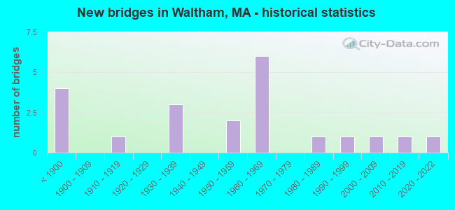
- New bridges - historical statistics
- 4Before 1900
- 11910-1919
- 31930-1939
- 21950-1959
- 61960-1969
- 11980-1989
- 11990-1999
- 12000-2009
- 12010-2019
- 12020-2022

- Reconstructed bridges - Historical Statistics
- 11920-1929
- 11930-1939
- 21940-1949
- 11950-1959
- 11960-1969
- 21970-1979
- 21980-1989


- Bridge Condition - Deck
- 7.1%Very good
- 14.3%Good
- 28.6%Satisfactory
- 35.7%Fair
- 14.3%Poor

- Bridge Condition - Superstructure
- 5.9%Very good
- 52.9%Satisfactory
- 41.2%Fair

- Bridge Condition - Substructure
- 11.8%Very good
- 11.8%Good
- 11.8%Satisfactory
- 52.9%Fair
- 11.8%Poor

- Bridge Condition - Channel
- 20.0%Very good
- 20.0%Good
- 40.0%Satisfactory
- 20.0%Fair
Find on map >> Show street view
Structure Number: W040012C8MUNNBI, Location: AT CHARLES RIVER (Lat: 42.367083, Lng: -71.218125), Route carried "on" structure: City street , Year Built: 1850, Year Reconstructed: 1933, Status: Open, Structure Length: 3.34m (10.96ft), Average Daily Traffic: 20,252 (year 2018), Truck Traffic: 3%, Average Future Daily Traffic: 20,575 (year 2032), Features Intersected: WATER CHARLES RIVER, Facility Carried by Structure: HWY FARWELL ST
Minimum Vertical Clearance: 30+ m (98+ ft), Kilometerpoint: 0.676, Lanes on structure: 2, Owner: City or Municipal Highway Agency, Approaching Roadway Width: 12.2m (40.0ft), Skew: 1 degrees, Material/Design: Steel, Design/Construction: Truss - Deck, Number Of Spans In Main Unit: 1, Length of Maximum Span: 32.0m (105.0ft), Curb or Sidewalk Widths: Left: 1.8m (5.9ft), Right: 1.8m (5.9ft), Curb-To-Curb Width: 12.1m (39.7ft), Out-to-Out Width: 16.4m (53.8ft)
Condition: Deck: Fair, Superstructure: Fair, Substructure: Fair, Channel: Fair, Operating Rating: 40.5 metric tons, Method Used To Determine Operating Rating: Load Factor (LF), Inventory Rating: 24.2 metric tons, Method Used To Determine Inventory Rating: Load Factor (LF), Structural Evaluation: Somewhat better than minimum adequacy, Deck Geometry: Somewhat better than minimum adequacy, Waterway Adequacy: Better than present minimum criteria, Approach Roadway Alignment: Somewhat better than minimum adequacy, Length Of Structure Improvement: 3.40m (11.15ft), Designated Inspection Frequency: Every 24 months, Inspection Date: August 2021, Bridge Improvement Cost: $2,191,000, Roadway Improvement Cost: $220,000, Total Project Cost: $3,287,000 ( Estimate for 2022), Deck Structure Type: Concrete Cast-file-Place, Wearing Surface/Protective System: Wearing Surface: Bituminous
Find on map >> Show street view
Structure Number: W040022KGDOTNBI, Location: 0.35 MI SOUTH RTE 20 (Lat: 42.372556, Lng: -71.228764), Route carried "on" structure: City street , Year Built: 1877, Year Reconstructed: 1951, Status: Open, Structure Length: 2.74m (8.99ft), Average Daily Traffic: 16,601 (year 2018), Truck Traffic: 9%, Average Future Daily Traffic: 11,055 (year 2032), Features Intersected: WATER CHARLES RIVER, Facility Carried by Structure: HWY NEWTON ST
Minimum Vertical Clearance: 30+ m (98+ ft), Kilometerpoint: 0.563, Lanes on structure: 2, Owner: State Highway Agency, Approaching Roadway Width: 8.2m (26.9ft), Material/Design: Masonry, Design/Construction: Arch - Deck, Number Of Spans In Main Unit: 3, Length of Maximum Span: 8.2m (26.9ft), Curb or Sidewalk Widths: Left: 1.6m (5.2ft), Right: 1.7m (5.6ft), Curb-To-Curb Width: 8.2m (26.9ft), Out-to-Out Width: 12.6m (41.3ft)
Condition: Superstructure: Fair, Substructure: Fair, Channel: Fair, Structural Evaluation: Somewhat better than minimum adequacy, Deck Geometry: High priority of replacement, Waterway Adequacy: Better than present minimum criteria, Approach Roadway Alignment: Equal to present desirable criteria, Length Of Structure Improvement: 2.80m (9.19ft), Designated Inspection Frequency: Every 24 months, Underwater Inspection Frequency: Every 36 months, Inspection Date: March 2021, Underwater Inspection Date: March 2020, Bridge Improvement Cost: $1,386,000, Roadway Improvement Cost: $139,000, Total Project Cost: $2,080,000 ( Estimate for 2022), Wearing Surface/Protective System: Wearing Surface: Bituminous
Find on map >> Show street view
Structure Number: W040032C9MUNNBI, Location: 400 FT SO INT ELM & RIVER (Lat: 42.372917, Lng: -71.232500), Route carried "on" structure: City street , Year Built: 1850, Year Reconstructed: 1949, Status: Open, Structure Length: 7.19m (23.59ft), Average Daily Traffic: 8,600 (year 2021), Truck Traffic: 8%, Average Future Daily Traffic: 13,266 (year 2032), Features Intersected: WATER CHARLES RIVER, Facility Carried by Structure: HWY ELM ST
Minimum Vertical Clearance: 30+ m (98+ ft), Kilometerpoint: 0.322, Lanes on structure: 2, Owner: City or Municipal Highway Agency, Approaching Roadway Width: 9.1m (29.9ft), Material/Design: Concrete continuous, Design/Construction: Tee Beam, Number Of Spans In Main Unit: 4, Length of Maximum Span: 20.4m (66.9ft), Curb or Sidewalk Widths: Left: 1.4m (4.6ft), Right: 1.4m (4.6ft), Curb-To-Curb Width: 9.1m (29.9ft), Out-to-Out Width: 12.2m (40.0ft)
Condition: Deck: Satisfactory, Superstructure: Satisfactory, Substructure: Fair, Channel: Satisfactory, Operating Rating: 55.1 metric tons, Method Used To Determine Operating Rating: Allowable Stress (AS), Inventory Rating: 32.4 metric tons, Method Used To Determine Inventory Rating: Allowable Stress (AS), Structural Evaluation: Somewhat better than minimum adequacy, Deck Geometry: Meets minimum limits, Waterway Adequacy: Better than present minimum criteria, Approach Roadway Alignment: Somewhat better than minimum adequacy, Length Of Structure Improvement: 7.20m (23.62ft), Designated Inspection Frequency: Every 24 months, Underwater Inspection Frequency: Every 36 months, Inspection Date: September 2021, Underwater Inspection Date: October 2019, Bridge Improvement Cost: $3,451,000, Roadway Improvement Cost: $346,000, Total Project Cost: $5,177,000 ( Estimate for 2022), Deck Structure Type: Concrete Cast-file-Place, Wearing Surface/Protective System: Wearing Surface: Bituminous
Find on map >> Show street view
Structure Number: W040042CAMUNNBI, Location: .89 MI. N. NEWTON TWN.LN. (Lat: 42.373225, Lng: -71.236564), Route carried "on" structure: City street , Year Built: 1917, Year Reconstructed: 1943, Status: Open, Structure Length: 6.86m (22.51ft), Average Daily Traffic: 13,500 (year 2021), Truck Traffic: 5%, Average Future Daily Traffic: 37,114 (year 2032), Features Intersected: WATER CHARLES RIVER, Facility Carried by Structure: HWY MOODY ST
Minimum Vertical Clearance: 30+ m (98+ ft), Kilometerpoint: 1.432, Lanes on structure: 4, Base Highway Network: Yes, Owner: City or Municipal Highway Agency, Approaching Roadway Width: 13.7m (44.9ft), Material/Design: Concrete, Design/Construction: Arch - Deck, Number Of Spans In Main Unit: 9, Length of Maximum Span: 7.6m (24.9ft), Curb or Sidewalk Widths: Left: 2.7m (8.9ft), Right: 2.5m (8.2ft), Curb-To-Curb Width: 13.9m (45.6ft), Out-to-Out Width: 20.0m (65.6ft)
Condition: Superstructure: Satisfactory, Substructure: Fair, Channel: Satisfactory, Operating Rating: 72.5 metric tons, Method Used To Determine Operating Rating: Load Factor (LF), Inventory Rating: 43.4 metric tons, Method Used To Determine Inventory Rating: Load Factor (LF), Structural Evaluation: Somewhat better than minimum adequacy, Deck Geometry: High priority of replacement, Waterway Adequacy: Superior to present desirable criteria, Approach Roadway Alignment: Better than present minimum criteria, Length Of Structure Improvement: 6.90m (22.64ft), Designated Inspection Frequency: Every 24 months, Underwater Inspection Frequency: Every 36 months, Inspection Date: September 2021, Underwater Inspection Date: August 2021, Bridge Improvement Cost: $5,421,000, Roadway Improvement Cost: $543,000, Total Project Cost: $8,132,000 ( Estimate for 2022), Wearing Surface/Protective System: Wearing Surface: Bituminous
Find on map >> Show street view
Structure Number: W040052CBMUNNBI, Location: .6 MI. S. MAIN ST. (Lat: 42.368806, Lng: -71.243547), Route carried "on" structure: City street , Year Built: 1888, Year Reconstructed: 1975, Status: Open, Structure Length: 4.02m (13.19ft), Average Daily Traffic: 35,200 (year 2021), Truck Traffic: 10%, Average Future Daily Traffic: 42,957 (year 2032), Design Load: HS 20, Features Intersected: WATER CHARLES RIVER, Facility Carried by Structure: HWY PROSPECT ST
Minimum Vertical Clearance: 30+ m (98+ ft), Kilometerpoint: 0.966, Lanes on structure: 3, Owner: City or Municipal Highway Agency, Approaching Roadway Width: 9.8m (32.2ft), Material/Design: Masonry, Design/Construction: Arch - Deck, Number Of Spans In Main Unit: 3, Length of Maximum Span: 14.0m (45.9ft), Curb or Sidewalk Widths: Left: 1.5m (4.9ft), Right: 1.6m (5.2ft), Curb-To-Curb Width: 9.9m (32.5ft), Out-to-Out Width: 13.8m (45.3ft)
Condition: Superstructure: Satisfactory, Substructure: Satisfactory, Channel: Satisfactory, Operating Rating: 63.6 metric tons, Method Used To Determine Operating Rating: Load Factor (LF), Inventory Rating: 63.6 metric tons, Method Used To Determine Inventory Rating: Load Factor (LF), Structural Evaluation: Equal to present minimum criteria, Deck Geometry: High priority of replacement, Waterway Adequacy: Better than present minimum criteria, Approach Roadway Alignment: Somewhat better than minimum adequacy, Length Of Structure Improvement: 4.10m (13.45ft), Designated Inspection Frequency: Every 24 months, Underwater Inspection Frequency: Every 36 months, Inspection Date: September 2021, Underwater Inspection Date: August 2020, Bridge Improvement Cost: $2,590,000, Roadway Improvement Cost: $260,000, Total Project Cost: $3,886,000 ( Estimate for 2022), Wearing Surface/Protective System: Wearing Surface: Bituminous
Find on map >> Show street view
Structure Number: W04006BVNMUNNBI, Location: .6 KM. NE. OF NEWTON LINE (Lat: 42.361633, Lng: -71.245278), Route carried "on" structure: City street , Year Built: 2021, Status: Open, Structure Length: 1.48m (4.86ft), Average Daily Traffic: 2,760 (year 2021), Truck Traffic: 7%, Design Load: HL 93, Features Intersected: WATER CHARLES RIVER, Facility Carried by Structure: HWY WOERD AVE
Minimum Vertical Clearance: 30+ m (98+ ft), Kilometerpoint: 0.274, Lanes on structure: 2, Owner: City or Municipal Highway Agency, Approaching Roadway Width: 8.5m (27.9ft), Material/Design: Prestressed concrete, Design/Construction: Tee Beam, Number Of Spans In Main Unit: 1, Length of Maximum Span: 13.5m (44.3ft), Curb or Sidewalk Widths: Left: 1.7m (5.6ft), Right: 1.7m (5.6ft), Curb-To-Curb Width: 8.5m (27.9ft), Out-to-Out Width: 12.1m (39.7ft)
Condition: Deck: Very good, Superstructure: Very good, Substructure: Very good, Channel: Very good, Operating Rating: 42.1 metric tons, Method Used To Determine Operating Rating: Assigned ratings based on Load and Resistance Factor Design (LRFD) reported by rating factor (RF) using HL93 loadings, Inventory Rating: 32.4 metric tons, Method Used To Determine Inventory Rating: Assigned ratings based on Load and Resistance Factor Design (LRFD) reported by rating factor (RF) using HL93 loadings, Structural Evaluation: Equal to present desirable criteria, Deck Geometry: Meets minimum limits, Waterway Adequacy: Equal to present desirable criteria, Approach Roadway Alignment: Equal to present desirable criteria, Designated Inspection Frequency: Every 24 months, Inspection Date: June 2021, Deck Structure Type: Concrete Precast Panels, Wearing Surface/Protective System: Wearing Surface: Bituminous, Membrane: Other, Deck Protection: Other
Find on map >> Show street view
Structure Number: W04008AL5MUNNBI, Location: AT WESTON LINE (Lat: 42.354483, Lng: -71.263325), Route carried "on" structure: City street , Year Built: 2003, Status: Open, Structure Length: 2.01m (6.59ft), Average Daily Traffic: 16,293 (year 2019), Truck Traffic: 4%, Average Future Daily Traffic: 15,316 (year 2032), Design Load: HS 20, Features Intersected: WATER STONY BROOK, Facility Carried by Structure: HWY SOUTH ST
Minimum Vertical Clearance: 30+ m (98+ ft), Kilometerpoint: 0.016, Lanes on structure: 2, Owner: City or Municipal Highway Agency, Approaching Roadway Width: 9.1m (29.9ft), Material/Design: Steel, Design/Construction: Stringer/Multi-beam, Number Of Spans In Main Unit: 1, Length of Maximum Span: 19.2m (63.0ft), Curb or Sidewalk Widths: Left: 0.0m, Right: 2.7m (8.9ft), Curb-To-Curb Width: 9.1m (29.9ft), Out-to-Out Width: 12.8m (42.0ft)
Condition: Deck: Good, Superstructure: Satisfactory, Substructure: Good, Channel: Very good, Operating Rating: 66.7 metric tons, Method Used To Determine Operating Rating: Load Factor (LF), Inventory Rating: 49.8 metric tons, Method Used To Determine Inventory Rating: Load Factor (LF), Structural Evaluation: Equal to present minimum criteria, Deck Geometry: High priority of corrective action, Waterway Adequacy: Equal to present desirable criteria, Approach Roadway Alignment: Equal to present desirable criteria, Length Of Structure Improvement: 2.10m (6.89ft), Designated Inspection Frequency: Every 24 months, Inspection Date: October 2021, Bridge Improvement Cost: $852,000, Roadway Improvement Cost: $86,000, Total Project Cost: $1,279,000 ( Estimate for 2022), Deck Structure Type: Concrete Cast-file-Place, Wearing Surface/Protective System: Wearing Surface: Bituminous, Membrane: Built-up, Deck Protection: Epoxy Coated Reinforcing
Find on map >> Show street view
Structure Number: W040102NJDOT634, Location: 0.16 KM SOUTH JCT RT 20 (Lat: 42.375644, Lng: -71.228717), Route carried "on" structure: City street , Year Built: 1930, Year Reconstructed: 1977, Status: Posted for load, Structure Length: 0.91m (2.99ft), Average Daily Traffic: 8,400 (year 2018), Truck Traffic: 8%, Average Future Daily Traffic: 30,638 (year 2033), Features Intersected: RR MBTA/BMRR, Facility Carried by Structure: HWY NEWTON ST
Minimum Vertical Clearance: 30+ m (98+ ft), Kilometerpoint: 0.000, Lanes on structure: 2, Owner: State Highway Agency, Approaching Roadway Width: 9.8m (32.2ft), Skew: 2 degrees, Material/Design: Wood or Timber, Design/Construction: Stringer/Multi-beam, Number Of Spans In Main Unit: 1, Length of Maximum Span: 7.9m (25.9ft), Curb or Sidewalk Widths: Left: 1.8m (5.9ft), Right: 1.8m (5.9ft), Curb-To-Curb Width: 9.0m (29.5ft), Out-to-Out Width: 13.6m (44.6ft)
Condition: Deck: Good, Superstructure: Satisfactory, Substructure: Satisfactory, Operating Rating: 35.6 metric tons, Method Used To Determine Operating Rating: Allowable Stress (AS), Inventory Rating: 24.7 metric tons, Method Used To Determine Inventory Rating: Load Factor (LF), Structural Evaluation: Equal to present minimum criteria, Deck Geometry: High priority of replacement, Underclear: High priority of corrective action, Approach Roadway Alignment: Better than present minimum criteria, Length Of Structure Improvement: 1.00m (3.28ft), Designated Inspection Frequency: Every 24 months, Inspection Date: October 2021, Bridge Improvement Cost: $535,000, Roadway Improvement Cost: $54,000, Total Project Cost: $803,000 ( Estimate for 2022), Deck Structure Type: Wood or Timber, Wearing Surface/Protective System: Wearing Surface: Bituminous
Find on map >> Show street view
Structure Number: W040112NKDOT634, Location: 0.16 KM S CENTRAL ST (Lat: 42.375108, Lng: -71.231086), Route carried "on" structure: City street , Year Built: 1934, Year Reconstructed: 1989, Status: Posted for load, Structure Length: 1.13m (3.71ft), Average Daily Traffic: 2,100 (year 2018), Truck Traffic: 6%, Average Future Daily Traffic: 2,053 (year 2031), Features Intersected: RR MBTA/BMRR, Facility Carried by Structure: HWY JACKSON ST
Minimum Vertical Clearance: 30+ m (98+ ft), Kilometerpoint: 0.000, Lanes on structure: 2, Owner: State Highway Agency, Approaching Roadway Width: 6.4m (21.0ft), Skew: 1 degrees, Material/Design: Wood or Timber, Design/Construction: Stringer/Multi-beam, Number Of Spans In Main Unit: 1, Length of Maximum Span: 9.0m (29.5ft), Curb or Sidewalk Widths: Left: 1.8m (5.9ft), Right: 1.2m (3.9ft), Curb-To-Curb Width: 6.4m (21.0ft), Out-to-Out Width: 10.5m (34.4ft)
Condition: Deck: Satisfactory, Superstructure: Satisfactory, Substructure: Fair, Operating Rating: 18.2 metric tons, Method Used To Determine Operating Rating: Load Factor (LF), Inventory Rating: 12.3 metric tons, Method Used To Determine Inventory Rating: Load Factor (LF), Structural Evaluation: High priority of corrective action, Deck Geometry: High priority of replacement, Underclear: High priority of corrective action, Approach Roadway Alignment: Somewhat better than minimum adequacy, Bridge Posting: Required (Relationship of Operating Rating to Maximum Legal Load: > 39.9% below), Length Of Structure Improvement: 1.20m (3.94ft), Designated Inspection Frequency: Every 24 months, Inspection Date: July 2020, Bridge Improvement Cost: $495,000, Roadway Improvement Cost: $50,000, Total Project Cost: $743,000 ( Estimate for 2022), Deck Structure Type: Wood or Timber, Wearing Surface/Protective System: Wearing Surface: Bituminous
Find on map >> Show street view
Structure Number: W040152NHDOT634, Location: .16 KM E JCT 60 & 20 (Lat: 42.377858, Lng: -71.223644), Route carried "on" structure: US 20, Year Built: 1936, Year Reconstructed: 1991, Status: Posted for load, Structure Length: 7.13m (23.39ft), Average Daily Traffic: 28,190 (year 2020), Truck Traffic: 3%, Average Future Daily Traffic: 43,589 (year 2033), Design Load: H 20, Features Intersected: RR MBTA/BMRR
Minimum Vertical Clearance: 30+ m (98+ ft), Kilometerpoint: 235.730, Lanes on structure: 4, Base Highway Network: Yes, Owner: State Highway Agency, Approaching Roadway Width: 9.8m (32.2ft), Skew: 23 degrees, Material/Design: Steel, Design/Construction: Truss - Thru, Number Of Spans In Main Unit: 1, Number Of Approach Spans: 2, Length of Maximum Span: 35.1m (115.2ft), Curb or Sidewalk Widths: Left: 1.8m (5.9ft), Right: 1.8m (5.9ft), Curb-To-Curb Width: 18.3m (60.0ft), Out-to-Out Width: 25.9m (85.0ft)
Condition: Deck: Fair, Superstructure: Fair, Substructure: Fair, Operating Rating: 63.0 metric tons, Method Used To Determine Operating Rating: Load Factor (LF), Inventory Rating: 37.7 metric tons, Method Used To Determine Inventory Rating: Load Factor (LF), Structural Evaluation: Somewhat better than minimum adequacy, Deck Geometry: Somewhat better than minimum adequacy, Underclear: High priority of corrective action, Approach Roadway Alignment: Better than present minimum criteria, Length Of Structure Improvement: 7.20m (23.62ft), Designated Inspection Frequency: Every 24 months, Critical Feature Inspection Frequency: Every 24 months, Inspection Date: Febuary 2022, Critical Feature Inspection Date: Febuary 2022, Bridge Improvement Cost: $7,325,000, Roadway Improvement Cost: $733,000, Total Project Cost: $10,988,000 ( Estimate for 2022), Deck Structure Type: Concrete Cast-file-Place, Wearing Surface/Protective System: Wearing Surface: Bituminous, Membrane: Built-up
Find on map >> Show street view
Structure Number: W04018AWWMUNNBI, Location: 2.7 KM E OF RT.95 (Lat: 42.382247, Lng: -71.231167), Route carried "on" structure: City street , Year Built: 1999, Status: Open, Structure Length: 1.30m (4.27ft), Average Daily Traffic: 14,500 (year 2017), Truck Traffic: 4%, Average Future Daily Traffic: 26,848 (year 2032), Features Intersected: WATER LYMAN POND CREEK, Facility Carried by Structure: HWY LYMAN ST
Minimum Vertical Clearance: 30+ m (98+ ft), Kilometerpoint: 0.563, Lanes on structure: 2, Owner: City or Municipal Highway Agency, Approaching Roadway Width: 6.1m (20.0ft), Material/Design: Concrete, Design/Construction: Slab, Number Of Spans In Main Unit: 1, Length of Maximum Span: 12.1m (39.7ft), Curb or Sidewalk Widths: Left: 1.3m (4.3ft), Right: 0.9m (3.0ft), Curb-To-Curb Width: 6.1m (20.0ft), Out-to-Out Width: 9.4m (30.8ft)
Condition: Deck: Satisfactory, Superstructure: Satisfactory, Substructure: Very good, Channel: Good, Operating Rating: 66.1 metric tons, Method Used To Determine Operating Rating: Load Factor (LF), Inventory Rating: 39.5 metric tons, Method Used To Determine Inventory Rating: Load Factor (LF), Structural Evaluation: Equal to present minimum criteria, Deck Geometry: High priority of replacement, Waterway Adequacy: Somewhat better than minimum adequacy, Approach Roadway Alignment: Meets minimum limits, Length Of Structure Improvement: 1.40m (4.59ft), Designated Inspection Frequency: Every 24 months, Inspection Date: December 2021, Bridge Improvement Cost: $964,000, Roadway Improvement Cost: $97,000, Total Project Cost: $1,447,000 ( Estimate for 2022), Deck Structure Type: Concrete Cast-file-Place, Wearing Surface/Protective System: Wearing Surface: Epoxy Overlay, Deck Protection: Epoxy Coated Reinforcing
Find on map >> Show street view
Structure Number: W040202CDMUNNBI, Location: AT INT RIVER & NEWTON STS (Lat: 42.373361, Lng: -71.228172), Route carried "on" structure: City street , Year Built: 1984, Status: Open, Structure Length: 0.81m (2.66ft), Average Daily Traffic: 20,528 (year 2018), Truck Traffic: 6%, Average Future Daily Traffic: 37,903 (year 2032), Features Intersected: WATER BEAVER BROOK, Facility Carried by Structure: HWY RIVER ST
Minimum Vertical Clearance: 30+ m (98+ ft), Kilometerpoint: 0.000, Lanes on structure: 4, Owner: Town or Township Highway Agency, Approaching Roadway Width: 11.3m (37.1ft), Material/Design: Concrete, Design/Construction: Culvert, Number Of Spans In Main Unit: 2, Length of Maximum Span: 3.7m (12.1ft), Curb or Sidewalk Widths: Left: 1.4m (4.6ft), Right: 1.4m (4.6ft)
Condition: Channel: Satisfactory, Culverts: Satisfactory, Operating Rating: 97.2 metric tons, Method Used To Determine Operating Rating: Load Factor (LF), Inventory Rating: 58.3 metric tons, Method Used To Determine Inventory Rating: Load Factor (LF), Structural Evaluation: Equal to present minimum criteria, Waterway Adequacy: Equal to present desirable criteria, Approach Roadway Alignment: Equal to present desirable criteria, Length Of Structure Improvement: 1.00m (3.28ft), Designated Inspection Frequency: Every 24 months, Inspection Date: August 2021, Bridge Improvement Cost: $764,000, Roadway Improvement Cost: $77,000, Total Project Cost: $1,147,000 ( Estimate for 2022), Wearing Surface/Protective System: Wearing Surface: Bituminous
Find on map >> Show street view
Structure Number: W040242LEDOTNBI, Location: 1.4 KM SLY RT 2 (Lat: 42.415289, Lng: -71.257292), Route carried "on" structure: City street , Year Built: 1960, Status: Open, Structure Length: 6.55m (21.49ft), Average Daily Traffic: 24,727 (year 2018), Truck Traffic: 10%, Average Future Daily Traffic: 43,905 (year 2031), Design Load: H 20, Features Intersected: I 95 /ST128, Facility Carried by Structure: HWY TRAPELO RD
Minimum Vertical Clearance: 30+ m (98+ ft), Kilometerpoint: 1.352, Lanes on structure: 2, Lanes under structure: 8, Owner: State Highway Agency, Approaching Roadway Width: 14.6m (47.9ft), Skew: 1 degrees, Material/Design: Steel continuous, Design/Construction: Stringer/Multi-beam, Number Of Spans In Main Unit: 4, Length of Maximum Span: 24.7m (81.0ft), Curb or Sidewalk Widths: Left: 1.5m (4.9ft), Right: 1.5m (4.9ft), Curb-To-Curb Width: 15.8m (51.8ft), Out-to-Out Width: 19.8m (65.0ft)
Condition: Deck: Poor, Superstructure: Satisfactory, Substructure: Poor, Operating Rating: 44.7 metric tons, Method Used To Determine Operating Rating: Load Factor (LF), Inventory Rating: 26.7 metric tons, Method Used To Determine Inventory Rating: Load Factor (LF), Structural Evaluation: Meets minimum limits, Deck Geometry: Superior to present desirable criteria, Underclear: High priority of replacement, Approach Roadway Alignment: Better than present minimum criteria, Length Of Structure Improvement: 7.60m (24.93ft), Designated Inspection Frequency: Every 12 months, Other Special Inspection Frequency: Every 12 months, Inspection Date: July 2020, Other Special Inspection Date: July 2021, Bridge Improvement Cost: $6,927,000, Roadway Improvement Cost: $693,000, Total Project Cost: $10,391,000 ( Estimate for 2022), Deck Structure Type: Concrete Cast-file-Place, Wearing Surface/Protective System: Wearing Surface: Bituminous, Membrane: Built-up
Find on map >> Show street view
Structure Number: W040256G1DOTNBI, Location: .4 KM S OF 128 INT (Lat: 42.397342, Lng: -71.261297), Route carried "on" structure: City street , Year Built: 2011, Status: Open, Structure Length: 8.37m (27.46ft), Average Daily Traffic: 40,700 (year 2018), Truck Traffic: 8%, Design Load: HS 20, Features Intersected: I 95 /ST128, Facility Carried by Structure: HWY WINTER ST
Minimum Vertical Clearance: 30+ m (98+ ft), Kilometerpoint: 0.000, Lanes on structure: 7, Lanes under structure: 9, Base Highway Network: Yes, Owner: State Highway Agency, Approaching Roadway Width: 26.6m (87.3ft), Material/Design: Prestressed concrete continuous, Design/Construction: Stringer/Multi-beam, Number Of Spans In Main Unit: 4, Length of Maximum Span: 24.4m (80.1ft), Curb or Sidewalk Widths: Left: 1.6m (5.2ft), Right: 1.6m (5.2ft), Curb-To-Curb Width: 26.6m (87.3ft), Out-to-Out Width: 30.7m (100.7ft)
Condition: Deck: Satisfactory, Superstructure: Satisfactory, Substructure: Good, Operating Rating: 67.3 metric tons, Method Used To Determine Operating Rating: Load Factor (LF), Inventory Rating: 40.3 metric tons, Method Used To Determine Inventory Rating: Load Factor (LF), Structural Evaluation: Equal to present minimum criteria, Deck Geometry: Meets minimum limits, Underclear: High priority of corrective action, Approach Roadway Alignment: Equal to present desirable criteria, Length Of Structure Improvement: 8.40m (27.56ft), Designated Inspection Frequency: Every 24 months, Inspection Date: Febuary 2022, Bridge Improvement Cost: $5,228,000, Roadway Improvement Cost: $523,000, Total Project Cost: $7,843,000 ( Estimate for 2022), Deck Structure Type: Concrete Cast-file-Place, Wearing Surface/Protective System: Wearing Surface: Bituminous, Membrane: Preformed Fabric, Deck Protection: Epoxy Coated Reinforcing
Find on map >> Show street view
Structure Number: W040262F2DOTNBI, Location: .32 KM SLY RTS 20 & 128 (Lat: 42.367292, Lng: -71.269750), Route carried "on" structure: Interstate 95, Year Built: 1950, Year Reconstructed: 1962, Status: Open, Structure Length: 6.92m (22.70ft), Average Daily Traffic: 171,900 (year 2020), Truck Traffic: 10%, Average Future Daily Traffic: 295,329 (year 2031), Design Load: H 20, Features Intersected: RR MBTA/BMRR
Minimum Vertical Clearance: 30+ m (98+ ft), Kilometerpoint: 28.967, Lanes on structure: 9, Base Highway Network: Yes, Owner: State Highway Agency, Approaching Roadway Width: 43.3m (142.1ft), Skew: 25 degrees, Material/Design: Steel continuous, Design/Construction: Stringer/Multi-beam, Number Of Spans In Main Unit: 3, Length of Maximum Span: 24.7m (81.0ft), Curb-To-Curb Width: 37.2m (122.0ft), Out-to-Out Width: 45.5m (149.3ft)
Condition: Deck: Fair, Superstructure: Fair, Substructure: Fair, Operating Rating: 45.4 metric tons, Method Used To Determine Operating Rating: Load Factor (LF), Inventory Rating: 27.2 metric tons, Method Used To Determine Inventory Rating: Load Factor (LF), Structural Evaluation: Somewhat better than minimum adequacy, Deck Geometry: Meets minimum limits, Underclear: High priority of corrective action, Approach Roadway Alignment: Better than present minimum criteria, Length Of Structure Improvement: 7.00m (22.97ft), Designated Inspection Frequency: Every 24 months, Inspection Date: August 2020, Bridge Improvement Cost: $12,511,000, Roadway Improvement Cost: $1,252,000, Total Project Cost: $18,767,000 ( Estimate for 2022), Deck Structure Type: Concrete Cast-file-Place, Wearing Surface/Protective System: Wearing Surface: Bituminous, Membrane: Built-up
Find on map >> Show street view
Structure Number: W040282K3DOTNBI, Location: 0.5 MI NLY RT 20 (Lat: 42.376703, Lng: -71.266544), Route carried "on" structure: State highway 117, Year Built: 1962, Status: Open, Structure Length: 6.64m (21.78ft), Average Daily Traffic: 18,600 (year 2018), Truck Traffic: 3%, Average Future Daily Traffic: 61,435 (year 2032), Design Load: H 20, Features Intersected: I 95 /ST128
Minimum Vertical Clearance: 30+ m (98+ ft), Kilometerpoint: 48.660, Lanes on structure: 4, Lanes under structure: 8, Owner: State Highway Agency, Approaching Roadway Width: 14.6m (47.9ft), Skew: 2 degrees, Material/Design: Steel continuous, Design/Construction: Stringer/Multi-beam, Number Of Spans In Main Unit: 4, Length of Maximum Span: 22.9m (75.1ft), Curb or Sidewalk Widths: Left: 1.6m (5.2ft), Right: 1.6m (5.2ft), Curb-To-Curb Width: 14.6m (47.9ft), Out-to-Out Width: 18.5m (60.7ft)
Condition: Deck: Poor, Superstructure: Fair, Substructure: Poor, Operating Rating: 48.2 metric tons, Method Used To Determine Operating Rating: Load Factor (LF), Inventory Rating: 28.8 metric tons, Method Used To Determine Inventory Rating: Load Factor (LF), Structural Evaluation: Meets minimum limits, Deck Geometry: High priority of replacement, Underclear: High priority of replacement, Approach Roadway Alignment: Better than present minimum criteria, Length Of Structure Improvement: 7.70m (25.26ft), Designated Inspection Frequency: Every 12 months, Other Special Inspection Frequency: Every 12 months, Inspection Date: October 2021, Other Special Inspection Date: October 2021, Bridge Improvement Cost: $10,487,000, Roadway Improvement Cost: $1,049,000, Total Project Cost: $15,731,000 ( Estimate for 2022), Deck Structure Type: Concrete Cast-file-Place, Wearing Surface/Protective System: Wearing Surface: Bituminous, Membrane: Built-up
Find on map >> Show street view
Structure Number: W040292F1DOTNBI, Location: 0.96 KM SLY RT 20 (Lat: 42.362989, Lng: -71.270489), Route carried "on" structure: Interstate 128, Year Built: 1950, Year Reconstructed: 1960, Status: Open, Structure Length: 0.88m (2.89ft), Average Daily Traffic: 172,999 (year 2018), Truck Traffic: 10%, Average Future Daily Traffic: 272,003 (year 2032), Design Load: H 20, Features Intersected: WATER STONY BROOK
Minimum Vertical Clearance: 30+ m (98+ ft), Kilometerpoint: 28.646, Lanes on structure: 8, Base Highway Network: Yes, Owner: State Highway Agency, Approaching Roadway Width: 18.3m (60.0ft), Skew: 20 degrees, Material/Design: Concrete, Design/Construction: Culvert, Number Of Spans In Main Unit: 2, Length of Maximum Span: 3.7m (12.1ft), Curb-To-Curb Width: 36.6m (120.1ft), Out-to-Out Width: 43.3m (142.1ft)
Condition: Channel: Good, Culverts: Satisfactory, Operating Rating: 44.1 metric tons, Method Used To Determine Operating Rating: Allowable Stress (AS), Inventory Rating: 32.4 metric tons, Method Used To Determine Inventory Rating: Allowable Stress (AS), Structural Evaluation: Equal to present minimum criteria, Deck Geometry: Better than present minimum criteria, Waterway Adequacy: Better than present minimum criteria, Approach Roadway Alignment: Equal to present desirable criteria, Length Of Structure Improvement: 0.10m (0.33ft), Designated Inspection Frequency: Every 24 months, Underwater Inspection Frequency: Every 60 months, Inspection Date: December 2021, Underwater Inspection Date: December 2017, Bridge Improvement Cost: $83,000, Roadway Improvement Cost: $9,000, Total Project Cost: $125,000 ( Estimate for 2022), Wearing Surface/Protective System: Wearing Surface: Bituminous
Find on map >> Show street view
Structure Number: W040322E3DOTNBI, Location: RT 20 WB AT RT 128 (Lat: 42.372519, Lng: -71.268831), Route carried "on" structure: US 20, Year Built: 1960, Status: Open, Structure Length: 7.47m (24.51ft), Average Daily Traffic: 27,600 (year 2016), Truck Traffic: 13%, Average Future Daily Traffic: 49,432 (year 2031), Design Load: H 20, Features Intersected: I 95 /ST128
Minimum Vertical Clearance: 5.94m (19.49ft), Kilometerpoint: 231.900, Lanes on structure: 2, Lanes under structure: 8, Owner: State Highway Agency, Approaching Roadway Width: 11.0m (36.1ft), Skew: 1 degrees, Material/Design: Steel continuous, Design/Construction: Stringer/Multi-beam, Number Of Spans In Main Unit: 2, Number Of Approach Spans: 2, Length of Maximum Span: 26.2m (86.0ft), Curb or Sidewalk Widths: Left: 1.5m (4.9ft), Right: 0.8m (2.6ft), Curb-To-Curb Width: 11.0m (36.1ft), Out-to-Out Width: 14.1m (46.3ft)
Condition: Deck: Fair, Superstructure: Fair, Substructure: Fair, Operating Rating: 43.3 metric tons, Method Used To Determine Operating Rating: Load Factor (LF), Inventory Rating: 25.9 metric tons, Method Used To Determine Inventory Rating: Load Factor (LF), Structural Evaluation: Somewhat better than minimum adequacy, Deck Geometry: Meets minimum limits, Underclear: Meets minimum limits, Approach Roadway Alignment: Better than present minimum criteria, Length Of Structure Improvement: 7.50m (24.61ft), Designated Inspection Frequency: Every 24 months, Inspection Date: May 2020, Bridge Improvement Cost: $4,154,000, Roadway Improvement Cost: $416,000, Total Project Cost: $6,232,000 ( Estimate for 2022), Deck Structure Type: Concrete Cast-file-Place, Wearing Surface/Protective System: Wearing Surface: Bituminous, Membrane: Built-up
Find on map >> Show street view
Structure Number: W040332E4DOTNBI, Location: RT 20 EB AT RT 128 (Lat: 42.370061, Lng: -71.269314), Route carried "on" structure: US 20, Year Built: 1960, Status: Open, Structure Length: 7.56m (24.80ft), Average Daily Traffic: 29,250 (year 2014), Truck Traffic: 9%, Average Future Daily Traffic: 44,062 (year 2031), Design Load: H 20, Features Intersected: I 95 /ST128
Minimum Vertical Clearance: 5.33m (17.49ft), Kilometerpoint: 231.739, Lanes on structure: 2, Lanes under structure: 8, Base Highway Network: Yes, Owner: State Highway Agency, Approaching Roadway Width: 12.2m (40.0ft), Skew: 2 degrees, Material/Design: Steel continuous, Design/Construction: Stringer/Multi-beam, Number Of Spans In Main Unit: 4, Length of Maximum Span: 28.0m (91.9ft), Curb or Sidewalk Widths: Left: 0.8m (2.6ft), Right: 1.5m (4.9ft), Curb-To-Curb Width: 12.2m (40.0ft), Out-to-Out Width: 15.3m (50.2ft)
Condition: Deck: Fair, Superstructure: Fair, Substructure: Fair, Operating Rating: 31.7 metric tons, Method Used To Determine Operating Rating: Load Factor (LF), Inventory Rating: 19.1 metric tons, Method Used To Determine Inventory Rating: Load Factor (LF), Structural Evaluation: Meets minimum limits, Deck Geometry: Better than present minimum criteria, Underclear: Meets minimum limits, Approach Roadway Alignment: Equal to present desirable criteria, Bridge Posting: Required (Relationship of Operating Rating to Maximum Legal Load: 0.1 - 9.9% below), Length Of Structure Improvement: 7.60m (24.93ft), Designated Inspection Frequency: Every 24 months, Inspection Date: May 2020, Bridge Improvement Cost: $4,568,000, Roadway Improvement Cost: $457,000, Total Project Cost: $6,853,000 ( Estimate for 2022), Deck Structure Type: Concrete Cast-file-Place, Wearing Surface/Protective System: Wearing Surface: Bituminous, Membrane: Built-up
Find on map >> Show street view
Structure Number: L100172LXDOTNBI, Location: 0.5 MI SE RT 128 (Lat: 42.416667, Lng: -71.250000), Route carried "under" structure: State highway 2, Year Built: 1967, Structure Length: 0. m, Average Daily Traffic: 38,650 (year 0000), Features Intersected: ST 2 EB, Facility Carried by Structure: HWY SPRING ST
Minimum Vertical Clearance: 4.47m (14.67ft), Kilometerpoint: 0.000, Lanes on structure: 3, Lanes under structure: 2, Material/Design: Steel, Design/Construction: Stringer/Multi-beam, Length of Maximum Span: 33.2m (108.9ft)
Find on map >> Show street view
Structure Number: L100172LXDOTNBI, Location: 0.5 MI SE RT 128 (Lat: 42.416667, Lng: -71.250000), Route carried "under" structure: State highway 2, Year Built: 1967, Structure Length: 0. m, Average Daily Traffic: 38,650 (year 0000), Features Intersected: ST 2 WB, Facility Carried by Structure: HWY SPRING ST
Minimum Vertical Clearance: 4.47m (14.67ft), Kilometerpoint: 0.000, Lanes on structure: 3, Lanes under structure: 2, Material/Design: Steel, Design/Construction: Stringer/Multi-beam, Length of Maximum Span: 31.4m (103.0ft)