Bridge Statistics for Waldorf, Maryland (MD)
Condition, Traffic, Stress, Structural Evaluation, Project Costs
- National Bridge Inventory (NBI) Statistics
- 15Number of bridges
- 89ft / 26.6mTotal length
- $54,000Total costs
- 149,541Total average daily traffic
- 11,138Total average daily truck traffic
- 196,216Total future (year 2008) average daily traffic
- National Bridge Inventory (NBI) Registered Bridges for Waldorf
- No street view available for this location
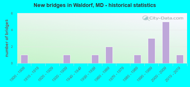
- New bridges - historical statistics
- 11900-1909
- 11930-1939
- 11950-1959
- 21960-1969
- 11980-1989
- 31990-1999
- 52000-2009
- 12010-2019
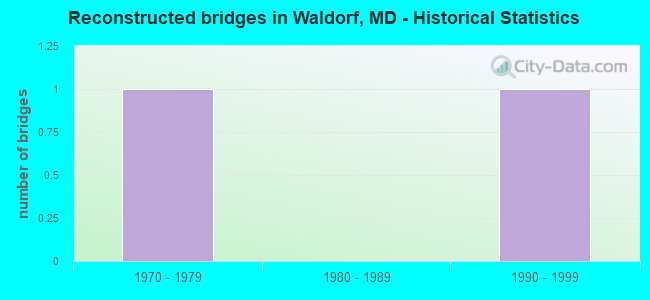
- Reconstructed bridges - Historical Statistics
- 11970-1979
- 01980-1989
- 11990-1999
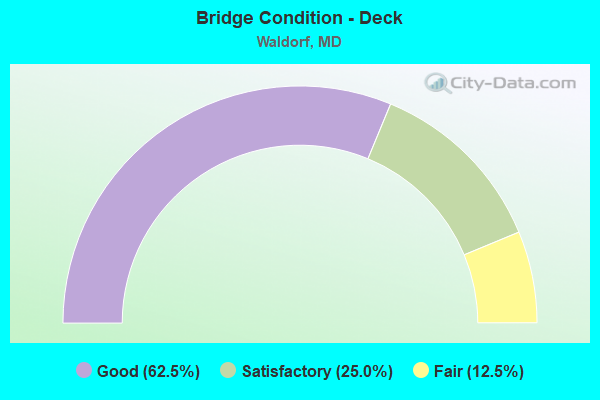
- Bridge Condition - Deck
- 62.5%Good
- 25.0%Satisfactory
- 12.5%Fair
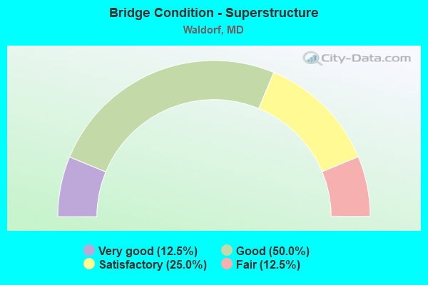
- Bridge Condition - Superstructure
- 12.5%Very good
- 50.0%Good
- 25.0%Satisfactory
- 12.5%Fair
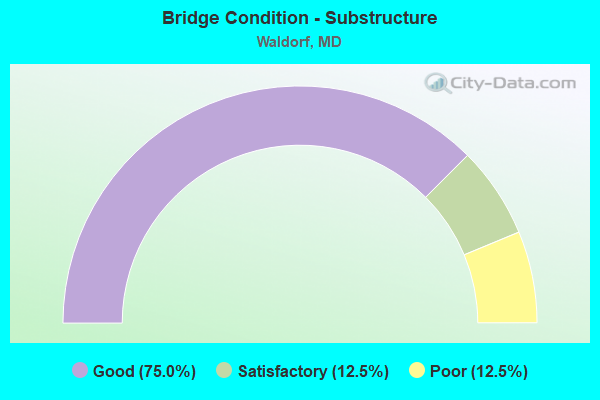
- Bridge Condition - Substructure
- 75.0%Good
- 12.5%Satisfactory
- 12.5%Poor
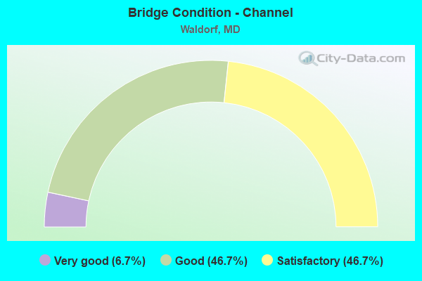
- Bridge Condition - Channel
- 6.7%Very good
- 46.7%Good
- 46.7%Satisfactory
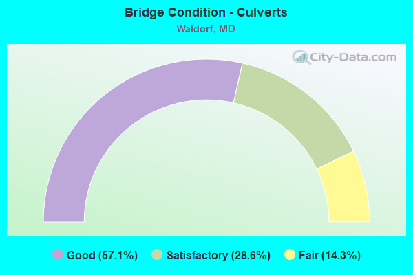
- Bridge Condition - Culverts
- 57.1%Good
- 28.6%Satisfactory
- 14.3%Fair
Find on map >> Show street view
Structure Number: 10000008002901, Location: 1.15 MILES WEST OF US 301 (Lat: 38.590056, Lng: -76.969922), Route carried "on" structure: State highway 227, Year Built: 1900, Status: Open, Structure Length: 0.64m (2.10ft), Average Daily Traffic: 5,771 (year 2009), Truck Traffic: 8%, Average Future Daily Traffic: 8,657 (year 2029), Features Intersected: PAGES SWAMP
Minimum Vertical Clearance: 30+ m (98+ ft), Kilometerpoint: 20.606, Lanes on structure: 2, Owner: State Highway Agency, Approaching Roadway Width: 7.9m (25.9ft), Skew: 1 degrees, Material/Design: Concrete, Design/Construction: Slab, Number Of Spans In Main Unit: 1, Length of Maximum Span: 6.1m (20.0ft), Curb-To-Curb Width: 9.9m (32.5ft), Out-to-Out Width: 9.9m (32.5ft)
Condition: Deck: Satisfactory, Superstructure: Satisfactory, Substructure: Good, Channel: Satisfactory, Operating Rating: 32.7 metric tons, Method Used To Determine Operating Rating: Field evaluation and documented engineering judgment, Inventory Rating: 32.7 metric tons, Method Used To Determine Inventory Rating: Field evaluation and documented engineering judgment, Structural Evaluation: Equal to present minimum criteria, Deck Geometry: Meets minimum limits, Waterway Adequacy: Superior to present desirable criteria, Approach Roadway Alignment: Equal to present minimum criteria, Length Of Structure Improvement: 0.64m (2.10ft), Designated Inspection Frequency: Every 24 months, Inspection Date: January 2022, Bridge Improvement Cost: $41,000, Roadway Improvement Cost: $4,000, Total Project Cost: $45,000, Deck Structure Type: Concrete Cast-file-Place, Wearing Surface/Protective System: Wearing Surface: Bituminous
Find on map >> Show street view
Structure Number: 10000008004102, Location: 0.41 M N OF BR NO 0802300 (Lat: 38.615956, Lng: -76.877247), Route carried "on" structure: State highway 5, Year Built: 1988, Status: Open, Structure Length: 1.43m (4.69ft), Average Daily Traffic: 32,802 (year 2009), Truck Traffic: 8%, Average Future Daily Traffic: 44,962 (year 2029), Design Load: HS 20, Features Intersected: TRIB TO JORDAN SWAMP
Minimum Vertical Clearance: 30+ m (98+ ft), Kilometerpoint: 17.593, Lanes on structure: 2, Base Highway Network: Yes, Owner: State Highway Agency, Approaching Roadway Width: 13.4m (44.0ft), Material/Design: Concrete, Design/Construction: Culvert, Length of Maximum Span: 4.6m (15.1ft)
Condition: Channel: Good, Culverts: Good, Operating Rating: 32.7 metric tons, Method Used To Determine Operating Rating: Field evaluation and documented engineering judgment, Inventory Rating: 32.7 metric tons, Method Used To Determine Inventory Rating: Field evaluation and documented engineering judgment, Structural Evaluation: Better than present minimum criteria, Waterway Adequacy: Equal to present desirable criteria, Approach Roadway Alignment: Equal to present desirable criteria, Designated Inspection Frequency: Every 24 months, Inspection Date: September 2021
Find on map >> Show street view
Structure Number: 10000008004601, Location: 1.99 MILES EAST OF MD 6 (Lat: 38.543497, Lng: -76.927108), Route carried "on" structure: State highway 488, Year Built: 1931, Year Reconstructed: 1976, Status: Open, Structure Length: 1.25m (4.10ft), Average Daily Traffic: 6,540 (year 2009), Truck Traffic: 8%, Average Future Daily Traffic: 7,990 (year 2026), Design Load: HS 20, Features Intersected: KERRICK SWAMP
Minimum Vertical Clearance: 30+ m (98+ ft), Kilometerpoint: 3.189, Lanes on structure: 2, Owner: State Highway Agency, Approaching Roadway Width: 13.4m (44.0ft), Material/Design: Concrete, Design/Construction: Slab, Number Of Spans In Main Unit: 2, Length of Maximum Span: 5.5m (18.0ft), Curb-To-Curb Width: 14.6m (47.9ft), Out-to-Out Width: 17.7m (58.1ft)
Condition: Deck: Good, Superstructure: Good, Substructure: Satisfactory, Channel: Satisfactory, Operating Rating: 52.6 metric tons, Method Used To Determine Operating Rating: Load Factor (LF), Inventory Rating: 31.7 metric tons, Method Used To Determine Inventory Rating: Load Factor (LF), Structural Evaluation: Equal to present minimum criteria, Deck Geometry: Superior to present desirable criteria, Waterway Adequacy: Superior to present desirable criteria, Approach Roadway Alignment: Equal to present desirable criteria, Designated Inspection Frequency: Every 24 months, Underwater Inspection Frequency: Every 48 months, Inspection Date: December 2021, Deck Structure Type: Concrete Cast-file-Place, Wearing Surface/Protective System: Wearing Surface: Bituminous
Find on map >> Show street view
Structure Number: 10000016005801, Location: ON CHARLES CO LINE (Lat: 38.658169, Lng: -76.874303), Route carried "on" structure: US 301, Year Built: 1950, Year Reconstructed: 1997, Status: Open, Structure Length: 1.68m (5.51ft), Average Daily Traffic: 73,212 (year 2006), Truck Traffic: 8%, Average Future Daily Traffic: 84,413 (year 2026), Design Load: HS 20+Mod, Features Intersected: MATTAWOMAN CREEK
Minimum Vertical Clearance: 30+ m (98+ ft), Kilometerpoint: 0.002, Lanes on structure: 11, Base Highway Network: Yes, Owner: State Highway Agency, Approaching Roadway Width: 46.3m (151.9ft), Skew: 22 degrees, Material/Design: Steel, Design/Construction: Stringer/Multi-beam, Number Of Spans In Main Unit: 1, Length of Maximum Span: 15.5m (50.9ft), Curb-To-Curb Width: 46.4m (152.2ft), Out-to-Out Width: 47.3m (155.2ft)
Condition: Deck: Good, Superstructure: Satisfactory, Substructure: Good, Channel: Very good, Inventory Rating: 64.9 metric tons, Method Used To Determine Inventory Rating: Load Factor (LF), Structural Evaluation: Equal to present minimum criteria, Deck Geometry: Superior to present desirable criteria, Waterway Adequacy: Superior to present desirable criteria, Approach Roadway Alignment: Equal to present desirable criteria, Designated Inspection Frequency: Every 24 months, Inspection Date: November 2020, Deck Structure Type: Concrete Cast-file-Place, Wearing Surface/Protective System: Wearing Surface: Integral Concrete, Deck Protection: Epoxy Coated Reinforcing
Find on map >> Show street view
Structure Number: 200000CH000203, Location: 0.3 MI S OF SMALLWOOD DR (Lat: 38.614917, Lng: -76.971500), Route carried "on" structure: County highway 50, Year Built: 2006, Status: Open, Structure Length: 1.16m (3.81ft), Average Daily Traffic: 3,100 (year 2007), Truck Traffic: 5%, Average Future Daily Traffic: 4,464 (year 2030), Features Intersected: UNNAMED TRIBUTARY, Facility Carried by Structure: MIDDLETOWN ROAD
Minimum Vertical Clearance: 30+ m (98+ ft), Kilometerpoint: 0.000, Lanes on structure: 4, Owner: County Highway Agency, Approaching Roadway Width: 9.1m (29.9ft), Skew: 2 degrees, Material/Design: Concrete, Design/Construction: Culvert, Length of Maximum Span: 0.0m
Condition: Channel: Good, Culverts: Good, Structural Evaluation: Better than present minimum criteria, Waterway Adequacy: Superior to present desirable criteria, Approach Roadway Alignment: Equal to present desirable criteria, Designated Inspection Frequency: Every 24 months, Inspection Date: November 2021
Find on map >> Show street view
Structure Number: 200000CH001103, Location: 135 FT S BUNKER HILL RD (Lat: 38.650842, Lng: -76.971278), Route carried "on" structure: County highway 54, Year Built: 2000, Status: Open, Structure Length: 1.83m (6.00ft), Average Daily Traffic: 100 (year 1988), Truck Traffic: 5%, Average Future Daily Traffic: 4,000 (year 2008), Design Load: HS 20, Features Intersected: PINEY BRANCH, Facility Carried by Structure: DAVIS ROAD
Minimum Vertical Clearance: 30+ m (98+ ft), Kilometerpoint: 0.064, Lanes on structure: 2, Owner: County Highway Agency, Approaching Roadway Width: 11.0m (36.1ft), Skew: 4 degrees, Material/Design: Steel, Design/Construction: Stringer/Multi-beam, Number Of Spans In Main Unit: 1, Length of Maximum Span: 17.1m (56.1ft), Curb or Sidewalk Widths: Left: 0.0m, Right: 1.5m (4.9ft), Curb-To-Curb Width: 11.0m (36.1ft), Out-to-Out Width: 12.8m (42.0ft)
Condition: Deck: Satisfactory, Superstructure: Good, Substructure: Good, Channel: Satisfactory, Operating Rating: 47.2 metric tons, Method Used To Determine Operating Rating: Load Factor (LF), Inventory Rating: 28.1 metric tons, Method Used To Determine Inventory Rating: Load Factor (LF), Structural Evaluation: Better than present minimum criteria, Deck Geometry: Superior to present desirable criteria, Waterway Adequacy: Better than present minimum criteria, Approach Roadway Alignment: Better than present minimum criteria, Designated Inspection Frequency: Every 12 months, Inspection Date: September 2021, Deck Structure Type: Corrugated Steel, Wearing Surface/Protective System: Wearing Surface: Bituminous
Find on map >> Show street view
Structure Number: 200000CH001902, Location: 1 mile East of US 301 (Lat: 38.655203, Lng: -76.858633), Route carried "on" structure: County highway 603, Year Built: 1960, Status: Open, Structure Length: 0.76m (2.49ft), Average Daily Traffic: 100 (year 1990), Truck Traffic: 1%, Average Future Daily Traffic: 200 (year 2010), Features Intersected: TRIB. OF MATTAWOMAN CREE, Facility Carried by Structure: COUNTRY LANE
Minimum Vertical Clearance: 30+ m (98+ ft), Kilometerpoint: 0.000, Lanes on structure: 2, Owner: County Highway Agency, Approaching Roadway Width: 7.3m (24.0ft), Material/Design: Concrete, Design/Construction: Culvert, Length of Maximum Span: 3.7m (12.1ft), Curb or Sidewalk Widths: Left: 3.1m (10.2ft), Right: 3.1m (10.2ft), Curb-To-Curb Width: 9.8m (32.2ft), Out-to-Out Width: 10.4m (34.1ft)
Condition: Channel: Good, Culverts: Fair, Operating Rating: 53.5 metric tons, Method Used To Determine Operating Rating: Load Factor (LF), Inventory Rating: 32.2 metric tons, Method Used To Determine Inventory Rating: Load Factor (LF), Structural Evaluation: Somewhat better than minimum adequacy, Deck Geometry: Equal to present desirable criteria, Waterway Adequacy: Equal to present minimum criteria, Approach Roadway Alignment: Equal to present minimum criteria, Length Of Structure Improvement: 0.88m (2.89ft), Designated Inspection Frequency: Every 12 months, Inspection Date: September 2021, Wearing Surface/Protective System: Wearing Surface: Bituminous
Find on map >> Show street view
Structure Number: 200000CH002001, Location: 1 Mile West of US 301 (Lat: 38.632111, Lng: -76.935247), Route carried "on" structure: County highway 1452, Year Built: 1995, Status: Open, Structure Length: 1.37m (4.49ft), Average Daily Traffic: 208 (year 2017), Truck Traffic: 5%, Average Future Daily Traffic: 322 (year 2039), Features Intersected: PINEY BRANCH, Facility Carried by Structure: CONSTITUTION DRIVE
Minimum Vertical Clearance: 30+ m (98+ ft), Kilometerpoint: 0.000, Lanes on structure: 2, Owner: County Highway Agency, Approaching Roadway Width: 9.1m (29.9ft), Skew: 3 degrees, Material/Design: Concrete, Design/Construction: Culvert, Number Of Spans In Main Unit: 1, Length of Maximum Span: 12.2m (40.0ft), Curb or Sidewalk Widths: Left: 1.5m (4.9ft), Right: 1.5m (4.9ft), Curb-To-Curb Width: 9.1m (29.9ft), Out-to-Out Width: 12.2m (40.0ft)
Condition: Channel: Satisfactory, Culverts: Satisfactory, Operating Rating: 32.7 metric tons, Method Used To Determine Operating Rating: Field evaluation and documented engineering judgment, Inventory Rating: 32.7 metric tons, Method Used To Determine Inventory Rating: Field evaluation and documented engineering judgment, Structural Evaluation: Equal to present minimum criteria, Deck Geometry: Equal to present minimum criteria, Waterway Adequacy: Equal to present desirable criteria, Approach Roadway Alignment: Equal to present desirable criteria, Designated Inspection Frequency: Every 24 months, Inspection Date: August 2021, Wearing Surface/Protective System: Wearing Surface: Bituminous
Find on map >> Show street view
Structure Number: 200000CH002601, Location: 2.1 MI S OF BILLINGSLEY (Lat: 38.560242, Lng: -76.933433), Route carried "on" structure: County highway 623, Year Built: 2008, Status: Open, Structure Length: 2.74m (8.99ft), Average Daily Traffic: 1,197 (year 2017), Truck Traffic: 5%, Average Future Daily Traffic: 1,859 (year 2039), Design Load: HS 25 or greater, Features Intersected: KERRICK SWAMP, Facility Carried by Structure: SAINT CHARLES PKWY
Minimum Vertical Clearance: 30+ m (98+ ft), Kilometerpoint: 0.000, Lanes on structure: 4, Owner: County Highway Agency, Approaching Roadway Width: 22.3m (73.2ft), Skew: 30 degrees, Material/Design: Prestressed concrete, Design/Construction: Stringer/Multi-beam, Number Of Spans In Main Unit: 1, Length of Maximum Span: 26.8m (87.9ft), Curb or Sidewalk Widths: Left: 0.0m, Right: 0.4m (1.3ft), Curb-To-Curb Width: 22.2m (72.8ft), Out-to-Out Width: 28.0m (91.9ft)
Condition: Deck: Good, Superstructure: Very good, Substructure: Good, Channel: Good, Operating Rating: 75.3 metric tons, Method Used To Determine Operating Rating: Load Factor (LF), Inventory Rating: 44.9 metric tons, Method Used To Determine Inventory Rating: Load Factor (LF), Structural Evaluation: Better than present minimum criteria, Deck Geometry: Superior to present desirable criteria, Waterway Adequacy: Superior to present desirable criteria, Approach Roadway Alignment: Equal to present desirable criteria, Designated Inspection Frequency: Every 24 months, Inspection Date: August 2021, Deck Structure Type: Concrete Cast-file-Place, Wearing Surface/Protective System: Wearing Surface: Monolithic Concrete, Deck Protection: Epoxy Coated Reinforcing
Find on map >> Show street view
Structure Number: 200000CH002703, Location: 0.24 MI E OF MIDDLETOWN (Lat: 38.609556, Lng: -76.970181), Route carried "on" structure: County highway 47, Year Built: 2006, Status: Open, Structure Length: 1.43m (4.69ft), Average Daily Traffic: 8,260 (year 2007), Truck Traffic: 5%, Average Future Daily Traffic: 11,925 (year 2030), Features Intersected: UNNAMED TRIBUTARY, Facility Carried by Structure: BILLINGSLEY ROAD
Minimum Vertical Clearance: 30+ m (98+ ft), Kilometerpoint: 0.000, Lanes on structure: 4, Owner: County Highway Agency, Approaching Roadway Width: 9.8m (32.2ft), Material/Design: Concrete, Design/Construction: Culvert, Length of Maximum Span: 14.3m (46.9ft), Curb or Sidewalk Widths: Left: 0.0m, Right: 3.0m (9.8ft)
Condition: Channel: Satisfactory, Culverts: Good, Structural Evaluation: Better than present minimum criteria, Waterway Adequacy: Superior to present desirable criteria, Approach Roadway Alignment: Equal to present desirable criteria, Designated Inspection Frequency: Every 24 months, Inspection Date: November 2021
Find on map >> Show street view
Structure Number: 200000CH002903, Location: .4 MI N OF BILLINGSLEY RD (Lat: 38.612797, Lng: -76.956322), Route carried "on" structure: County highway 1831, Year Built: 2005, Status: Open, Structure Length: 1.52m (4.99ft), Average Daily Traffic: 220 (year 2010), Truck Traffic: 1%, Average Future Daily Traffic: 1,400 (year 2030), Features Intersected: WETLANDS, Facility Carried by Structure: SILENT CREEK ROAD
Minimum Vertical Clearance: 30+ m (98+ ft), Kilometerpoint: 0.000, Lanes on structure: 2, Owner: County Highway Agency, Approaching Roadway Width: 9.1m (29.9ft), Material/Design: Steel, Design/Construction: Culvert, Length of Maximum Span: 0.0m, Curb-To-Curb Width: 9.1m (29.9ft), Out-to-Out Width: 15.0m (49.2ft)
Condition: Channel: Good, Culverts: Satisfactory, Structural Evaluation: Equal to present minimum criteria, Deck Geometry: Equal to present minimum criteria, Waterway Adequacy: Superior to present desirable criteria, Approach Roadway Alignment: Equal to present desirable criteria, Designated Inspection Frequency: Every 24 months, Inspection Date: October 2021
Find on map >> Show street view
Structure Number: 200000CH003704, Location: 0.76 MI SE OF MD RTE 228 (Lat: 38.637811, Lng: -76.950583), Route carried "on" structure: County highway , Year Built: 2015, Status: Open, Structure Length: 2.64m (8.66ft), Average Daily Traffic: 500 (year 2015), Truck Traffic: 5%, Average Future Daily Traffic: 750 (year 2035), Features Intersected: PINEY BRANCH, Facility Carried by Structure: MCDANIEL ROAD
Minimum Vertical Clearance: 30+ m (98+ ft), Kilometerpoint: 0.000, Lanes on structure: 2, Owner: County Highway Agency, Approaching Roadway Width: 8.5m (27.9ft), Material/Design: Concrete, Design/Construction: Culvert, Number Of Spans In Main Unit: 2, Length of Maximum Span: 12.8m (42.0ft), Curb or Sidewalk Widths: Left: 0.0m, Right: 2.4m (7.9ft), Curb-To-Curb Width: 9.2m (30.2ft), Out-to-Out Width: 12.8m (42.0ft)
Condition: Channel: Good, Culverts: Good, Operating Rating: 73.2 metric tons, Method Used To Determine Operating Rating: Load and Resistance Factor Rating (LRFR) rating reported by rating factor(RF) method using HL-93 loadings, Inventory Rating: 56.7 metric tons, Method Used To Determine Inventory Rating: Load and Resistance Factor Rating (LRFR) rating reported by rating factor(RF) method using HL-93 loadings, Structural Evaluation: Better than present minimum criteria, Deck Geometry: Equal to present minimum criteria, Waterway Adequacy: Superior to present desirable criteria, Approach Roadway Alignment: Superior to present desirable criteria, Designated Inspection Frequency: Every 24 months, Inspection Date: October 2021
Find on map >> Show street view
Structure Number: 200000CH004001, Location: 2.5 MI E OF MD 5 (Lat: 38.614611, Lng: -76.832500), Route carried "on" structure: State highway 1120, Year Built: 1969, Status: Posted for load, Structure Length: 1.36m (4.46ft), Average Daily Traffic: 4,300 (year 2015), Truck Traffic: 8%, Average Future Daily Traffic: 4,730 (year 2035), Design Load: HS 20, Features Intersected: ZEKIAH SWAMP RUN, Facility Carried by Structure: POPLAR HILL ROAD
Minimum Vertical Clearance: 30+ m (98+ ft), Kilometerpoint: 4.650, Lanes on structure: 2, Owner: County Highway Agency, Approaching Roadway Width: 6.1m (20.0ft), Skew: 2 degrees, Material/Design: Wood or Timber, Design/Construction: Stringer/Multi-beam, Number Of Spans In Main Unit: 2, Length of Maximum Span: 6.7m (22.0ft), Curb-To-Curb Width: 9.1m (29.9ft), Out-to-Out Width: 9.4m (30.8ft)
Condition: Deck: Fair, Superstructure: Fair, Substructure: Poor, Channel: Good, Operating Rating: 18.6 metric tons, Method Used To Determine Operating Rating: Allowable Stress (AS), Inventory Rating: 11.3 metric tons, Method Used To Determine Inventory Rating: Allowable Stress (AS), Structural Evaluation: High priority of corrective action, Deck Geometry: Meets minimum limits, Waterway Adequacy: Somewhat better than minimum adequacy, Approach Roadway Alignment: Better than present minimum criteria, Bridge Posting: Required (Relationship of Operating Rating to Maximum Legal Load: > 39.9% below), Length Of Structure Improvement: 1.40m (4.59ft), Designated Inspection Frequency: Every 12 months, Inspection Date: September 2021, Bridge Improvement Cost: $6,000, Total Project Cost: $9,000, Deck Structure Type: Wood or Timber, Wearing Surface/Protective System: Wearing Surface: Bituminous
Find on map >> Show street view
Structure Number: 200000CH0071013, Location: 2.5 MI E OF ST CHAR. PKWY (Lat: 38.575083, Lng: -76.876283), Route carried "on" structure: County highway 47, Year Built: 1994, Status: Open, Structure Length: 3.41m (11.19ft), Average Daily Traffic: 6,616 (year 2017), Truck Traffic: 5%, Average Future Daily Traffic: 10,273 (year 2039), Design Load: HS 25 or greater, Features Intersected: PINEY BRANCH, Facility Carried by Structure: BILLINGSLEY RD EBR
Minimum Vertical Clearance: 30+ m (98+ ft), Kilometerpoint: 0.000, Lanes on structure: 2, Base Highway Network: Yes, Owner: County Highway Agency, Approaching Roadway Width: 11.6m (38.1ft), Skew: 1 degrees, Material/Design: Steel, Design/Construction: Stringer/Multi-beam, Number Of Spans In Main Unit: 1, Length of Maximum Span: 32.6m (107.0ft), Curb-To-Curb Width: 11.6m (38.1ft), Out-to-Out Width: 12.6m (41.3ft)
Condition: Deck: Good, Superstructure: Good, Substructure: Good, Channel: Satisfactory, Inventory Rating: 85.7 metric tons, Method Used To Determine Inventory Rating: Load Factor (LF), Structural Evaluation: Better than present minimum criteria, Deck Geometry: Better than present minimum criteria, Waterway Adequacy: Equal to present desirable criteria, Approach Roadway Alignment: Equal to present desirable criteria, Designated Inspection Frequency: Every 24 months, Inspection Date: August 2021, Deck Structure Type: Concrete Cast-file-Place, Wearing Surface/Protective System: Wearing Surface: Monolithic Concrete, Deck Protection: Epoxy Coated Reinforcing
Find on map >> Show street view
Structure Number: 200000CH0071014, Location: 2.5 MI E OF ST CHAR. PKWY (Lat: 38.575467, Lng: -76.876067), Route carried "on" structure: County highway 47, Year Built: 1994, Status: Open, Structure Length: 3.41m (11.19ft), Average Daily Traffic: 6,615 (year 2017), Truck Traffic: 5%, Average Future Daily Traffic: 10,271 (year 2039), Design Load: HS 25 or greater, Features Intersected: PINEY BRANCH, Facility Carried by Structure: BILLINGSLEY RD WBR
Minimum Vertical Clearance: 30+ m (98+ ft), Kilometerpoint: 0.000, Lanes on structure: 2, Base Highway Network: Yes, Owner: County Highway Agency, Approaching Roadway Width: 13.4m (44.0ft), Skew: 1 degrees, Material/Design: Steel, Design/Construction: Stringer/Multi-beam, Number Of Spans In Main Unit: 1, Length of Maximum Span: 32.6m (107.0ft), Curb-To-Curb Width: 13.4m (44.0ft), Out-to-Out Width: 14.4m (47.2ft)
Condition: Deck: Good, Superstructure: Good, Substructure: Good, Channel: Satisfactory, Inventory Rating: 60.3 metric tons, Method Used To Determine Inventory Rating: Load Factor (LF), Structural Evaluation: Better than present minimum criteria, Deck Geometry: Superior to present desirable criteria, Waterway Adequacy: Equal to present desirable criteria, Approach Roadway Alignment: Equal to present desirable criteria, Designated Inspection Frequency: Every 24 months, Inspection Date: August 2021, Deck Structure Type: Concrete Cast-file-Place, Wearing Surface/Protective System: Wearing Surface: Monolithic Concrete, Deck Protection: Epoxy Coated Reinforcing