Bridge Statistics for Waikoloa Village, Hawaii (HI)
Condition, Traffic, Stress, Structural Evaluation, Project Costs
- National Bridge Inventory (NBI) Statistics
- 18Number of bridges
- 118ft / 36.0mTotal length
- $3,345,000Total costs
- 170,200Total average daily traffic
- 12,388Total average daily truck traffic
- 170,413Total future (year 2025) average daily traffic
- National Bridge Inventory (NBI) Registered Bridges for Waikoloa Village
- No street view available for this location
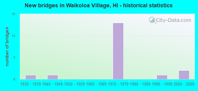
- New bridges - historical statistics
- 11930-1939
- 11940-1949
- 131970-1979
- 11990-1999
- 22000-2009


- Bridge Condition - Deck
- 20.0%Very good
- 20.0%Good
- 60.0%Satisfactory

- Bridge Condition - Superstructure
- 20.0%Very good
- 60.0%Good
- 20.0%Satisfactory

- Bridge Condition - Substructure
- 40.0%Good
- 60.0%Satisfactory

- Bridge Condition - Channel
- 70.6%Very good
- 23.5%Good
- 5.9%Fair

- Bridge Condition - Culverts
- 53.8%Good
- 23.1%Satisfactory
- 23.1%Fair
Find on map >> Show street view
Structure Number: 1000190301371, Location: 6.88MI N/KEAHOLE AIR ACC (Lat: 19.813519, Lng: -155.977042), Route carried "on" structure: US 19, Year Built: 1974, Status: Open, Structure Length: 0.88m (2.89ft), Average Daily Traffic: 13,400 (year 2017), Truck Traffic: 8%, Average Future Daily Traffic: 13,450 (year 2025), Design Load: HS 20, Features Intersected: UNNAMED GULLY, Facility Carried by Structure: QUEEN KAAHUMANU H
Minimum Vertical Clearance: 30+ m (98+ ft), Kilometerpoint: 138.303, Lanes on structure: 2, Base Highway Network: Yes, Owner: State Highway Agency, Approaching Roadway Width: 13.4m (44.0ft), Material/Design: Steel, Design/Construction: Culvert, Number Of Spans In Main Unit: 3, Length of Maximum Span: 2.4m (7.9ft), Curb-To-Curb Width: 13.4m (44.0ft), Out-to-Out Width: 28.7m (94.2ft)
Condition: Channel: Very good, Culverts: Good, Operating Rating: 45.4 metric tons, Method Used To Determine Operating Rating: Allowable Stress (AS), Inventory Rating: 32.7 metric tons, Method Used To Determine Inventory Rating: Allowable Stress (AS), Structural Evaluation: Better than present minimum criteria, Deck Geometry: Equal to present minimum criteria, Waterway Adequacy: Equal to present desirable criteria, Approach Roadway Alignment: Equal to present desirable criteria, Designated Inspection Frequency: Every 24 months, Inspection Date: May 2020, Wearing Surface/Protective System: Wearing Surface: Bituminous
Find on map >> Show street view
Structure Number: 100019030155, Location: 8.67MI N/KEAHOLE AIR (Lat: 19.824061, Lng: -155.952411), Route carried "on" structure: US 19, Year Built: 1974, Status: Open, Structure Length: 0.88m (2.89ft), Average Daily Traffic: 13,400 (year 2017), Truck Traffic: 8%, Average Future Daily Traffic: 13,450 (year 2025), Design Load: HS 20, Features Intersected: UNNAMED GULLY, Facility Carried by Structure: QUEEN KAAHUMANU H
Minimum Vertical Clearance: 30+ m (98+ ft), Kilometerpoint: 135.423, Lanes on structure: 2, Base Highway Network: Yes, Owner: State Highway Agency, Approaching Roadway Width: 13.4m (44.0ft), Material/Design: Steel, Design/Construction: Culvert, Number Of Spans In Main Unit: 3, Length of Maximum Span: 2.4m (7.9ft), Curb-To-Curb Width: 13.4m (44.0ft), Out-to-Out Width: 27.4m (89.9ft)
Condition: Channel: Very good, Culverts: Good, Operating Rating: 45.4 metric tons, Method Used To Determine Operating Rating: Allowable Stress (AS), Inventory Rating: 32.7 metric tons, Method Used To Determine Inventory Rating: Allowable Stress (AS), Structural Evaluation: Better than present minimum criteria, Deck Geometry: Equal to present minimum criteria, Waterway Adequacy: Equal to present desirable criteria, Approach Roadway Alignment: Equal to present desirable criteria, Designated Inspection Frequency: Every 24 months, Inspection Date: May 2020, Wearing Surface/Protective System: Wearing Surface: Bituminous
Find on map >> Show street view
Structure Number: 1000190301572, Location: 8.89MI N/KEAHOLE AIR ACC (Lat: 19.825694, Lng: -155.949561), Route carried "on" structure: US 19, Year Built: 1974, Status: Open, Structure Length: 0.70m (2.30ft), Average Daily Traffic: 13,400 (year 2017), Truck Traffic: 8%, Average Future Daily Traffic: 13,450 (year 2025), Design Load: HS 20, Features Intersected: UNNAMED GULLY, Facility Carried by Structure: QUEEN KAAHUMANU H
Minimum Vertical Clearance: 30+ m (98+ ft), Kilometerpoint: 135.069, Lanes on structure: 2, Base Highway Network: Yes, Owner: State Highway Agency, Approaching Roadway Width: 13.4m (44.0ft), Material/Design: Steel, Design/Construction: Culvert, Number Of Spans In Main Unit: 4, Length of Maximum Span: 1.2m (3.9ft), Curb-To-Curb Width: 13.4m (44.0ft), Out-to-Out Width: 27.4m (89.9ft)
Condition: Channel: Very good, Culverts: Good, Operating Rating: 45.4 metric tons, Method Used To Determine Operating Rating: Allowable Stress (AS), Inventory Rating: 32.7 metric tons, Method Used To Determine Inventory Rating: Allowable Stress (AS), Structural Evaluation: Better than present minimum criteria, Deck Geometry: Equal to present minimum criteria, Waterway Adequacy: Better than present minimum criteria, Approach Roadway Alignment: Equal to present desirable criteria, Designated Inspection Frequency: Every 24 months, Inspection Date: May 2020, Wearing Surface/Protective System: Wearing Surface: Bituminous
Find on map >> Show street view
Structure Number: 1000190301682, Location: 10.00MI N/KEAHOLE AIR ACC (Lat: 19.834058, Lng: -155.935006), Route carried "on" structure: US 19, Year Built: 1974, Status: Open, Structure Length: 1.10m (3.61ft), Average Daily Traffic: 13,400 (year 2017), Truck Traffic: 8%, Average Future Daily Traffic: 13,450 (year 2025), Design Load: HS 20, Features Intersected: UNNAMED GULLY, Facility Carried by Structure: QUEEN KAAHUMANU H
Minimum Vertical Clearance: 30+ m (98+ ft), Kilometerpoint: 133.298, Lanes on structure: 2, Base Highway Network: Yes, Owner: State Highway Agency, Approaching Roadway Width: 13.4m (44.0ft), Material/Design: Steel, Design/Construction: Culvert, Number Of Spans In Main Unit: 4, Length of Maximum Span: 2.1m (6.9ft), Curb-To-Curb Width: 13.4m (44.0ft), Out-to-Out Width: 27.4m (89.9ft)
Condition: Channel: Very good, Culverts: Good, Operating Rating: 45.4 metric tons, Method Used To Determine Operating Rating: Allowable Stress (AS), Inventory Rating: 32.7 metric tons, Method Used To Determine Inventory Rating: Allowable Stress (AS), Structural Evaluation: Better than present minimum criteria, Deck Geometry: Equal to present minimum criteria, Waterway Adequacy: Equal to present desirable criteria, Approach Roadway Alignment: Equal to present desirable criteria, Designated Inspection Frequency: Every 24 months, Inspection Date: May 2020, Wearing Surface/Protective System: Wearing Surface: Bituminous
Find on map >> Show street view
Structure Number: 1000190302111, Location: 14.28MI N/KEAHOLE AIR ACC (Lat: 19.883794, Lng: -155.898736), Route carried "on" structure: US 19, Year Built: 1974, Status: Open, Structure Length: 1.46m (4.79ft), Average Daily Traffic: 13,400 (year 2017), Truck Traffic: 8%, Average Future Daily Traffic: 13,450 (year 2025), Design Load: HS 20, Features Intersected: UNNAMED GULLY, Facility Carried by Structure: QUEEN KAAHUMANU H
Minimum Vertical Clearance: 30+ m (98+ ft), Kilometerpoint: 126.394, Lanes on structure: 2, Base Highway Network: Yes, Owner: State Highway Agency, Approaching Roadway Width: 13.4m (44.0ft), Material/Design: Steel, Design/Construction: Culvert, Number Of Spans In Main Unit: 4, Length of Maximum Span: 3.0m (9.8ft), Curb-To-Curb Width: 13.4m (44.0ft), Out-to-Out Width: 23.8m (78.1ft)
Condition: Channel: Very good, Culverts: Good, Operating Rating: 45.4 metric tons, Method Used To Determine Operating Rating: Allowable Stress (AS), Inventory Rating: 32.7 metric tons, Method Used To Determine Inventory Rating: Allowable Stress (AS), Structural Evaluation: Better than present minimum criteria, Deck Geometry: Equal to present minimum criteria, Waterway Adequacy: Equal to present desirable criteria, Approach Roadway Alignment: Equal to present desirable criteria, Designated Inspection Frequency: Every 24 months, Inspection Date: May 2020, Wearing Surface/Protective System: Wearing Surface: Bituminous
Find on map >> Show street view
Structure Number: 1000190302173, Location: 14.90MI N/KEAHOLE AIR ACC (Lat: 19.892000, Lng: -155.894914), Route carried "on" structure: US 19, Year Built: 1974, Status: Open, Structure Length: 1.74m (5.71ft), Average Daily Traffic: 13,400 (year 2017), Truck Traffic: 8%, Average Future Daily Traffic: 13,450 (year 2025), Design Load: HS 20, Features Intersected: UNNAMED GULLY, Facility Carried by Structure: QUEEN KAAHUMANU H
Minimum Vertical Clearance: 30+ m (98+ ft), Kilometerpoint: 125.397, Lanes on structure: 2, Base Highway Network: Yes, Owner: State Highway Agency, Approaching Roadway Width: 13.4m (44.0ft), Material/Design: Steel, Design/Construction: Culvert, Number Of Spans In Main Unit: 5, Length of Maximum Span: 2.7m (8.9ft), Curb-To-Curb Width: 13.4m (44.0ft), Out-to-Out Width: 29.9m (98.1ft)
Condition: Channel: Very good, Culverts: Good, Operating Rating: 45.4 metric tons, Method Used To Determine Operating Rating: Allowable Stress (AS), Inventory Rating: 32.7 metric tons, Method Used To Determine Inventory Rating: Allowable Stress (AS), Structural Evaluation: Better than present minimum criteria, Deck Geometry: Equal to present minimum criteria, Waterway Adequacy: Equal to present desirable criteria, Approach Roadway Alignment: Equal to present desirable criteria, Designated Inspection Frequency: Every 24 months, Inspection Date: May 2020, Wearing Surface/Protective System: Wearing Surface: Bituminous
Find on map >> Show street view
Structure Number: 1000190302653, Location: 19.70MI N/KEAHOLE AIR ACC (Lat: 19.938125, Lng: -155.840003), Route carried "on" structure: US 19, Year Built: 1974, Status: Open, Structure Length: 2.50m (8.20ft), Average Daily Traffic: 13,200 (year 2017), Truck Traffic: 6%, Average Future Daily Traffic: 13,710 (year 2025), Design Load: HS 20, Features Intersected: UNNAMED GULLY, Facility Carried by Structure: QUEEN KAAHUMANU H
Minimum Vertical Clearance: 30+ m (98+ ft), Kilometerpoint: 117.672, Lanes on structure: 2, Base Highway Network: Yes, Owner: State Highway Agency, Approaching Roadway Width: 13.4m (44.0ft), Material/Design: Steel, Design/Construction: Culvert, Number Of Spans In Main Unit: 4, Length of Maximum Span: 5.5m (18.0ft), Curb-To-Curb Width: 13.4m (44.0ft), Out-to-Out Width: 29.9m (98.1ft)
Condition: Channel: Very good, Culverts: Satisfactory, Operating Rating: 45.4 metric tons, Method Used To Determine Operating Rating: Allowable Stress (AS), Inventory Rating: 32.7 metric tons, Method Used To Determine Inventory Rating: Allowable Stress (AS), Structural Evaluation: Equal to present minimum criteria, Deck Geometry: Equal to present minimum criteria, Waterway Adequacy: Equal to present desirable criteria, Approach Roadway Alignment: Equal to present desirable criteria, Designated Inspection Frequency: Every 24 months, Inspection Date: May 2020, Wearing Surface/Protective System: Wearing Surface: Bituminous
Find on map >> Show street view
Structure Number: 1000190302754, Location: 20 99MI N/KEAHOLE AIR ACC (Lat: 19.949483, Lng: -155.830983), Route carried "on" structure: US 19, Year Built: 1974, Status: Open, Structure Length: 2.10m (6.89ft), Average Daily Traffic: 13,200 (year 2017), Truck Traffic: 6%, Average Future Daily Traffic: 13,710 (year 2025), Design Load: HS 20, Features Intersected: UNMD GLH. AUWAIAKEAKUA, Facility Carried by Structure: QUEEN KAAHUMANU H
Minimum Vertical Clearance: 30+ m (98+ ft), Kilometerpoint: 116.047, Lanes on structure: 2, Base Highway Network: Yes, Owner: State Highway Agency, Approaching Roadway Width: 13.4m (44.0ft), Skew: 9 degrees, Material/Design: Steel, Design/Construction: Culvert, Number Of Spans In Main Unit: 4, Length of Maximum Span: 4.6m (15.1ft), Curb-To-Curb Width: 13.4m (44.0ft), Out-to-Out Width: 30.2m (99.1ft)
Condition: Channel: Very good, Culverts: Good, Operating Rating: 45.4 metric tons, Method Used To Determine Operating Rating: Allowable Stress (AS), Inventory Rating: 32.7 metric tons, Method Used To Determine Inventory Rating: Allowable Stress (AS), Structural Evaluation: Better than present minimum criteria, Deck Geometry: Equal to present minimum criteria, Waterway Adequacy: Equal to present desirable criteria, Approach Roadway Alignment: Equal to present desirable criteria, Designated Inspection Frequency: Every 24 months, Inspection Date: May 2020
Find on map >> Show street view
Structure Number: 1000190302795, Location: 21.12MI N/KEAHOLE AIR ACC (Lat: 19.951086, Lng: -155.829900), Route carried "on" structure: US 19, Year Built: 1974, Status: Open, Structure Length: 1.10m (3.61ft), Average Daily Traffic: 13,200 (year 2017), Truck Traffic: 6%, Average Future Daily Traffic: 13,710 (year 2025), Design Load: HS 20, Features Intersected: UNNAMED GULLY, Facility Carried by Structure: QUEEN KAAHUMANU H
Minimum Vertical Clearance: 30+ m (98+ ft), Kilometerpoint: 115.387, Lanes on structure: 2, Base Highway Network: Yes, Owner: State Highway Agency, Approaching Roadway Width: 13.4m (44.0ft), Material/Design: Steel, Design/Construction: Culvert, Number Of Spans In Main Unit: 4, Length of Maximum Span: 2.1m (6.9ft), Curb-To-Curb Width: 13.4m (44.0ft), Out-to-Out Width: 27.4m (89.9ft)
Condition: Channel: Very good, Culverts: Fair, Operating Rating: 45.4 metric tons, Method Used To Determine Operating Rating: Allowable Stress (AS), Inventory Rating: 32.7 metric tons, Method Used To Determine Inventory Rating: Allowable Stress (AS), Structural Evaluation: Somewhat better than minimum adequacy, Deck Geometry: Equal to present minimum criteria, Waterway Adequacy: Equal to present desirable criteria, Approach Roadway Alignment: Equal to present desirable criteria, Designated Inspection Frequency: Every 24 months, Inspection Date: May 2020
Find on map >> Show street view
Structure Number: 1000190302911, Location: 22.28MI N/KEAHOLE AIR ACC (Lat: 19.970297, Lng: -155.820750), Route carried "on" structure: US 19, Year Built: 1974, Status: Open, Structure Length: 2.10m (6.89ft), Average Daily Traffic: 13,200 (year 2017), Truck Traffic: 6%, Average Future Daily Traffic: 13,710 (year 2025), Design Load: HS 20, Features Intersected: KAMAKOA GULCH, Facility Carried by Structure: QUEEN KAAHUMANU H
Minimum Vertical Clearance: 30+ m (98+ ft), Kilometerpoint: 113.520, Lanes on structure: 2, Base Highway Network: Yes, Owner: State Highway Agency, Approaching Roadway Width: 13.4m (44.0ft), Material/Design: Steel, Design/Construction: Culvert, Number Of Spans In Main Unit: 4, Length of Maximum Span: 4.6m (15.1ft), Curb-To-Curb Width: 13.4m (44.0ft), Out-to-Out Width: 45.1m (148.0ft)
Condition: Channel: Very good, Culverts: Fair, Operating Rating: 58.1 metric tons, Method Used To Determine Operating Rating: Allowable Stress (AS), Inventory Rating: 32.7 metric tons, Method Used To Determine Inventory Rating: Allowable Stress (AS), Structural Evaluation: Somewhat better than minimum adequacy, Deck Geometry: Equal to present minimum criteria, Waterway Adequacy: Equal to present desirable criteria, Approach Roadway Alignment: Equal to present desirable criteria, Designated Inspection Frequency: Every 24 months, Inspection Date: May 2020, Wearing Surface/Protective System: Wearing Surface: Bituminous
Find on map >> Show street view
Structure Number: 1000190306882, Location: 1.8 MI S OF HWY 19D/19C (Lat: 19.997047, Lng: -155.816258), Route carried "on" structure: ServiceUS 19, Year Built: 1993, Status: Open, Structure Length: 4.75m (15.58ft), Average Daily Traffic: 13,200 (year 2017), Truck Traffic: 6%, Average Future Daily Traffic: 12,402 (year 2025), Design Load: HS 20, Features Intersected: KEAKEALANI,SUB DIV.RD, Facility Carried by Structure: QUEEN KAAHUMANU
Minimum Vertical Clearance: 30+ m (98+ ft), Kilometerpoint: 110.752, Lanes on structure: 2, Lanes under structure: 2, Base Highway Network: Yes, Owner: State Highway Agency, Approaching Roadway Width: 9.8m (32.2ft), Skew: 2 degrees, Material/Design: Prestressed concrete, Design/Construction: Stringer/Multi-beam, Number Of Spans In Main Unit: 3, Length of Maximum Span: 21.9m (71.9ft), Curb-To-Curb Width: 13.4m (44.0ft), Out-to-Out Width: 14.6m (47.9ft)
Condition: Deck: Very good, Superstructure: Good, Substructure: Good, Operating Rating: 68.4 metric tons, Method Used To Determine Operating Rating: Load and Resistance Factor Rating (LRFR) rating reported by rating factor(RF) method using HL-93 loadings, Inventory Rating: 47.0 metric tons, Method Used To Determine Inventory Rating: Load and Resistance Factor Rating (LRFR) rating reported by rating factor(RF) method using HL-93 loadings, Structural Evaluation: Better than present minimum criteria, Deck Geometry: Equal to present minimum criteria, Underclear: Superior to present desirable criteria, Approach Roadway Alignment: Equal to present desirable criteria, Designated Inspection Frequency: Every 24 months, Inspection Date: May 2020, Deck Structure Type: Concrete Cast-file-Place, Wearing Surface/Protective System: Wearing Surface: Monolithic Concrete
Find on map >> Show street view
Structure Number: 1001900502561, Location: 2.13MI S/WAIKALOA (Lat: 19.850000, Lng: -155.738333), Route carried "on" structure: US 190, Year Built: 1940, Status: Open, Structure Length: 0.70m (2.30ft), Average Daily Traffic: 5,800 (year 2017), Truck Traffic: 10%, Average Future Daily Traffic: 5,524 (year 2025), Design Load: H 15, Features Intersected: KEAMUKU STRM, Facility Carried by Structure: MAMALAHOA HWY
Minimum Vertical Clearance: 30+ m (98+ ft), Kilometerpoint: 21.066, Lanes on structure: 2, Base Highway Network: Yes, Owner: State Highway Agency, Approaching Roadway Width: 10.1m (33.1ft), Skew: 2 degrees, Material/Design: Concrete, Design/Construction: Slab, Number Of Spans In Main Unit: 1, Length of Maximum Span: 7.0m (23.0ft), Curb-To-Curb Width: 9.8m (32.2ft), Out-to-Out Width: 10.4m (34.1ft)
Condition: Deck: Satisfactory, Superstructure: Satisfactory, Substructure: Satisfactory, Channel: Good, Operating Rating: 24.6 metric tons, Method Used To Determine Operating Rating: Load and Resistance Factor Rating (LRFR) rating reported by rating factor(RF) method using HL-93 loadings, Inventory Rating: 19.1 metric tons, Method Used To Determine Inventory Rating: Load and Resistance Factor Rating (LRFR) rating reported by rating factor(RF) method using HL-93 loadings, Structural Evaluation: Meets minimum limits, Deck Geometry: Meets minimum limits, Waterway Adequacy: Equal to present minimum criteria, Approach Roadway Alignment: Equal to present minimum criteria, Designated Inspection Frequency: Every 24 months, Inspection Date: March 2020, Deck Structure Type: Concrete Cast-file-Place, Wearing Surface/Protective System: Wearing Surface: Bituminous
Find on map >> Show street view
Structure Number: 1001900502693, Location: 0.80MI S/WAIKALOA (Lat: 19.866667, Lng: -155.727778), Route carried "on" structure: US 190, Year Built: 2001, Status: Open, Structure Length: 3.63m (11.91ft), Average Daily Traffic: 5,900 (year 2017), Truck Traffic: 8%, Average Future Daily Traffic: 5,524 (year 2025), Design Load: HS 20, Features Intersected: POPOO STRM, Facility Carried by Structure: MAMALAHOA HWY
Minimum Vertical Clearance: 30+ m (98+ ft), Kilometerpoint: 16.978, Lanes on structure: 2, Base Highway Network: Yes, Owner: State Highway Agency, Approaching Roadway Width: 10.1m (33.1ft), Material/Design: Prestressed concrete, Design/Construction: Stringer/Multi-beam, Number Of Spans In Main Unit: 1, Length of Maximum Span: 34.5m (113.2ft), Curb-To-Curb Width: 12.2m (40.0ft), Out-to-Out Width: 13.3m (43.6ft)
Condition: Deck: Satisfactory, Superstructure: Good, Substructure: Satisfactory, Channel: Very good, Operating Rating: 52.0 metric tons, Method Used To Determine Operating Rating: Load Factor (LF), Inventory Rating: 32.4 metric tons, Method Used To Determine Inventory Rating: Load Factor (LF), Structural Evaluation: Equal to present minimum criteria, Deck Geometry: Somewhat better than minimum adequacy, Waterway Adequacy: Better than present minimum criteria, Approach Roadway Alignment: Equal to present minimum criteria, Designated Inspection Frequency: Every 24 months, Inspection Date: March 2020, Total Project Cost: $1,449,000, Deck Structure Type: Concrete Cast-file-Place
Find on map >> Show street view
Structure Number: 1001900502763, Location: 0.12MI W/WAIKALOA DEVELOP (Lat: 19.875047, Lng: -155.724297), Route carried "on" structure: US 190, Year Built: 2001, Status: Open, Structure Length: 4.07m (13.35ft), Average Daily Traffic: 5,900 (year 2017), Truck Traffic: 8%, Average Future Daily Traffic: 5,524 (year 2025), Design Load: HS 20, Features Intersected: AUWAIAKEAKUA STRM, Facility Carried by Structure: MAMALAHOA HWY
Minimum Vertical Clearance: 30+ m (98+ ft), Kilometerpoint: 15.900, Lanes on structure: 2, Base Highway Network: Yes, Owner: State Highway Agency, Approaching Roadway Width: 13.5m (44.3ft), Skew: 3 degrees, Material/Design: Prestressed concrete, Design/Construction: Stringer/Multi-beam, Number Of Spans In Main Unit: 1, Length of Maximum Span: 37.8m (124.0ft), Curb-To-Curb Width: 12.2m (40.0ft), Out-to-Out Width: 13.3m (43.6ft)
Condition: Deck: Good, Superstructure: Very good, Substructure: Good, Channel: Very good, Operating Rating: 52.0 metric tons, Method Used To Determine Operating Rating: Load Factor (LF), Inventory Rating: 32.4 metric tons, Method Used To Determine Inventory Rating: Load Factor (LF), Structural Evaluation: Better than present minimum criteria, Deck Geometry: Somewhat better than minimum adequacy, Waterway Adequacy: Better than present minimum criteria, Approach Roadway Alignment: Equal to present minimum criteria, Designated Inspection Frequency: Every 24 months, Inspection Date: March 2020, Total Project Cost: $1,464,000, Deck Structure Type: Concrete Cast-file-Place
Find on map >> Show street view
Structure Number: 1001900503111, Location: 1.35MI S/SADDLE RD JUNCT (Lat: 19.918472, Lng: -155.696686), Route carried "on" structure: US 190, Year Built: 1930, Year Reconstructed: 1980, Status: Open, Structure Length: 1.10m (3.61ft), Average Daily Traffic: 5,900 (year 2017), Truck Traffic: 8%, Average Future Daily Traffic: 5,524 (year 2025), Design Load: HS 20, Features Intersected: KAMAKOA STRM #2, Facility Carried by Structure: MAMALAHOA HWY
Minimum Vertical Clearance: 30+ m (98+ ft), Kilometerpoint: 10.267, Lanes on structure: 2, Base Highway Network: Yes, Owner: State Highway Agency, Approaching Roadway Width: 11.0m (36.1ft), Material/Design: Steel, Design/Construction: Culvert, Number Of Spans In Main Unit: 3, Length of Maximum Span: 3.4m (11.2ft)
Condition: Channel: Fair, Culverts: Satisfactory, Operating Rating: 61.7 metric tons, Method Used To Determine Operating Rating: Allowable Stress (AS), Inventory Rating: 30.8 metric tons, Method Used To Determine Inventory Rating: Allowable Stress (AS), Structural Evaluation: Equal to present minimum criteria, Waterway Adequacy: Equal to present minimum criteria, Approach Roadway Alignment: Equal to present desirable criteria, Length Of Structure Improvement: 1.77m (5.81ft), Designated Inspection Frequency: Every 24 months, Inspection Date: March 2020, Roadway Improvement Cost: $29,000, Total Project Cost: $432,000
Find on map >> Show street view
Structure Number: 1680001100001, Location: TMK 6-8-03:15 (Lat: 19.924469, Lng: -155.797578), Route carried "on" structure: Other road 68000, Year Built: 1970, Status: Open, Structure Length: 2.35m (7.71ft), Average Daily Traffic: 100 (year 1981), Average Future Daily Traffic: 125 (year 2025), Design Load: HS 20, Features Intersected: AUWAIAKEAKUA GLH, Facility Carried by Structure: WAIKOLOA
Minimum Vertical Clearance: 30+ m (98+ ft), Kilometerpoint: 0.000, Lanes on structure: 4, Owner: County Highway Agency, Approaching Roadway Width: 21.3m (69.9ft), Material/Design: Concrete continuous, Design/Construction: Slab, Number Of Spans In Main Unit: 3, Length of Maximum Span: 6.7m (22.0ft), Curb or Sidewalk Widths: Left: 2.1m (6.9ft), Right: 2.1m (6.9ft), Curb-To-Curb Width: 18.3m (60.0ft), Out-to-Out Width: 23.5m (77.1ft)
Condition: Deck: Satisfactory, Superstructure: Good, Substructure: Satisfactory, Channel: Good, Operating Rating: 42.8 metric tons, Method Used To Determine Operating Rating: Load and Resistance Factor Rating (LRFR) rating reported by rating factor(RF) method using HL-93 loadings, Inventory Rating: 33.0 metric tons, Method Used To Determine Inventory Rating: Load and Resistance Factor Rating (LRFR) rating reported by rating factor(RF) method using HL-93 loadings, Structural Evaluation: Equal to present minimum criteria, Deck Geometry: Somewhat better than minimum adequacy, Waterway Adequacy: Equal to present minimum criteria, Approach Roadway Alignment: Equal to present desirable criteria, Designated Inspection Frequency: Every 24 months, Inspection Date: Febuary 2020, Deck Structure Type: Concrete Cast-file-Place
Find on map >> Show street view
Structure Number: 1680001100002, Location: TMK 6-8-03:3 (Lat: 19.930594, Lng: -155.787486), Route carried "on" structure: Other road 68000, Year Built: 1970, Status: Open, Structure Length: 0.64m (2.10ft), Average Daily Traffic: 100 (year 1981), Average Future Daily Traffic: 125 (year 2025), Design Load: HS 20, Features Intersected: AUWAIAKEAKUA GLH, Facility Carried by Structure: PANIOLO ST
Minimum Vertical Clearance: 30+ m (98+ ft), Kilometerpoint: 0.000, Lanes on structure: 2, Owner: County Highway Agency, Approaching Roadway Width: 19.5m (64.0ft), Material/Design: Concrete, Design/Construction: Culvert, Number Of Spans In Main Unit: 2, Length of Maximum Span: 3.0m (9.8ft), Curb or Sidewalk Widths: Left: 3.0m (9.8ft), Right: 3.0m (9.8ft), Curb-To-Curb Width: 19.5m (64.0ft), Out-to-Out Width: 28.0m (91.9ft)
Condition: Channel: Good, Culverts: Satisfactory, Operating Rating: 41.8 metric tons, Method Used To Determine Operating Rating: Load and Resistance Factor Rating (LRFR) rating reported by rating factor(RF) method using HL-93 loadings, Inventory Rating: 32.1 metric tons, Method Used To Determine Inventory Rating: Load and Resistance Factor Rating (LRFR) rating reported by rating factor(RF) method using HL-93 loadings, Structural Evaluation: Equal to present minimum criteria, Deck Geometry: Superior to present desirable criteria, Waterway Adequacy: Equal to present minimum criteria, Approach Roadway Alignment: Equal to present desirable criteria, Designated Inspection Frequency: Every 24 months, Inspection Date: Febuary 2020, Deck Structure Type: Concrete Cast-file-Place
Find on map >> Show street view
Structure Number: 1680001100003, Location: TMK 6-8-03:2 (Lat: 19.933589, Lng: -155.791639), Route carried "on" structure: Other road 68000, Year Built: 1970, Status: Open, Structure Length: 4.24m (13.91ft), Average Daily Traffic: 100 (year 1981), Average Future Daily Traffic: 125 (year 2025), Design Load: HS 20, Features Intersected: AUWAIAKEAKUA GLH, Facility Carried by Structure: LAUKULA ST
Minimum Vertical Clearance: 30+ m (98+ ft), Kilometerpoint: 0.000, Lanes on structure: 2, Owner: County Highway Agency, Approaching Roadway Width: 12.2m (40.0ft), Skew: 1 degrees, Material/Design: Concrete, Design/Construction: Culvert, Number Of Spans In Main Unit: 2, Length of Maximum Span: 3.0m (9.8ft), Curb or Sidewalk Widths: Left: 4.3m (14.1ft), Right: 4.3m (14.1ft), Curb-To-Curb Width: 12.2m (40.0ft), Out-to-Out Width: 23.5m (77.1ft)
Condition: Channel: Good, Culverts: Fair, Operating Rating: 55.7 metric tons, Method Used To Determine Operating Rating: Load and Resistance Factor Rating (LRFR) rating reported by rating factor(RF) method using HL-93 loadings, Inventory Rating: 42.8 metric tons, Method Used To Determine Inventory Rating: Load and Resistance Factor Rating (LRFR) rating reported by rating factor(RF) method using HL-93 loadings, Structural Evaluation: Somewhat better than minimum adequacy, Deck Geometry: Superior to present desirable criteria, Waterway Adequacy: Better than present minimum criteria, Approach Roadway Alignment: Equal to present desirable criteria, Designated Inspection Frequency: Every 24 months, Inspection Date: Febuary 2020, Deck Structure Type: Concrete Cast-file-Place, Wearing Surface/Protective System: Wearing Surface: Bituminous