Bridge Statistics for Wahpeton, North Dakota (ND)
Condition, Traffic, Stress, Structural Evaluation, Project Costs
- National Bridge Inventory (NBI) Statistics
- 15Number of bridges
- 184ft / 56.0mTotal length
- $331,000Total costs
- 44,955Total average daily traffic
- 3,877Total average daily truck traffic
- National Bridge Inventory (NBI) Registered Bridges for Wahpeton
- No street view available for this location
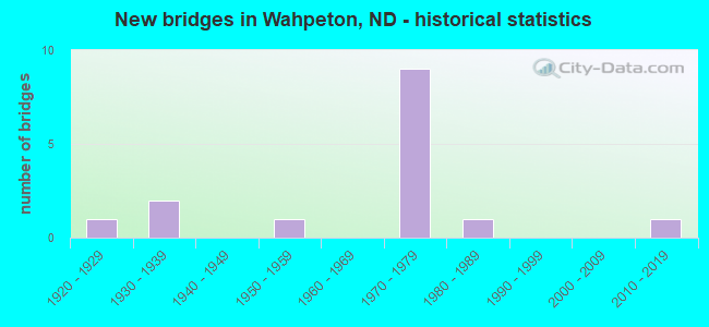
- New bridges - historical statistics
- 11920-1929
- 21930-1939
- 11950-1959
- 91970-1979
- 11980-1989
- 12010-2019

- Reconstructed bridges - Historical Statistics
- 11980-1989
- 21990-1999
- 32000-2009


- Bridge Condition - Deck
- 20.0%Good
- 40.0%Satisfactory
- 40.0%Fair

- Bridge Condition - Superstructure
- 50.0%Good
- 40.0%Satisfactory
- 10.0%Fair

- Bridge Condition - Substructure
- 20.0%Good
- 40.0%Satisfactory
- 40.0%Fair

- Bridge Condition - Channel
- 11.1%Very good
- 11.1%Good
- 44.4%Satisfactory
- 33.3%Fair

- Bridge Condition - Culverts
- 33.3%Good
- 66.7%Satisfactory
Find on map >> Show street view
Structure Number: 3912924, Location: 3 WEST OF WAHPETON (Lat: 46.282808, Lng: -96.684519), Route carried "on" structure: County highway , Year Built: 1982, Status: Posted for load, Structure Length: 3.69m (12.11ft), Average Daily Traffic: 100 (year 2018), Truck Traffic: 12%, Average Future Daily Traffic: 100 (year 2038), Design Load: H 20, Features Intersected: WILD RICE RIVER, Facility Carried by Structure: COUNTY HIGHWAY
Minimum Vertical Clearance: 30+ m (98+ ft), Kilometerpoint: 0.000, Lanes on structure: 2, Owner: County Highway Agency, Approaching Roadway Width: 7.3m (24.0ft), Skew: 3 degrees, Material/Design: Prestressed concrete continuous, Design/Construction: Box Beam or Girders - Single/Spread, Number Of Spans In Main Unit: 2, Length of Maximum Span: 17.7m (58.1ft), Curb-To-Curb Width: 8.5m (27.9ft), Out-to-Out Width: 9.8m (32.2ft)
Condition: Deck: Good, Superstructure: Good, Substructure: Good, Channel: Fair, Operating Rating: 19.4 metric tons, Method Used To Determine Operating Rating: Load and Resistance Factor Rating (LRFR) rating reported by rating factor(RF) method using HL-93 loadings, Inventory Rating: 10.0 metric tons, Method Used To Determine Inventory Rating: Load and Resistance Factor Rating (LRFR) rating reported by rating factor(RF) method using HL-93 loadings, Structural Evaluation: High priority of corrective action, Deck Geometry: Better than present minimum criteria, Waterway Adequacy: Equal to present desirable criteria, Approach Roadway Alignment: Better than present minimum criteria, Bridge Posting: Required (Relationship of Operating Rating to Maximum Legal Load: 10.0 - 19.9% below), Designated Inspection Frequency: Every 24 months, Inspection Date: July 2020, Deck Structure Type: Concrete Cast-file-Place, Wearing Surface/Protective System: Wearing Surface: Monolithic Concrete
Find on map >> Show street view
Structure Number: 3913227, Location: 1 WEST 2 SOUTH WAHPETON (Lat: 46.239314, Lng: -96.631181), Route carried "on" structure: County highway , Year Built: 1934, Status: Posted for load, Structure Length: 0.76m (2.49ft), Average Daily Traffic: 10 (year 2018), Average Future Daily Traffic: 10 (year 2038), Features Intersected: WILD RICE RIVER, Facility Carried by Structure: COUNTY HIGHWAY
Minimum Vertical Clearance: 30+ m (98+ ft), Kilometerpoint: 0.000, Lanes on structure: 2, Owner: County Highway Agency, Approaching Roadway Width: 3.7m (12.1ft), Material/Design: Steel, Design/Construction: Stringer/Multi-beam, Number Of Spans In Main Unit: 1, Length of Maximum Span: 7.0m (23.0ft), Curb or Sidewalk Widths: Left: 0.1m (0.3ft), Right: 0.1m (0.3ft), Curb-To-Curb Width: 5.2m (17.1ft), Out-to-Out Width: 5.5m (18.0ft)
Condition: Deck: Fair, Superstructure: Satisfactory, Substructure: Fair, Channel: Fair, Operating Rating: 10.2 metric tons, Method Used To Determine Operating Rating: Load Factor (LF), Inventory Rating: 6.1 metric tons, Method Used To Determine Inventory Rating: Load Factor (LF), Structural Evaluation: High priority of replacement, Deck Geometry: High priority of corrective action, Waterway Adequacy: Better than present minimum criteria, Approach Roadway Alignment: Equal to present minimum criteria, Bridge Posting: Required (Relationship of Operating Rating to Maximum Legal Load: > 39.9% below), Length Of Structure Improvement: 2.68m (8.79ft), Designated Inspection Frequency: Every 24 months, Inspection Date: July 2020, Bridge Improvement Cost: $121,000, Roadway Improvement Cost: $12,000, Total Project Cost: $182,000, Deck Structure Type: Wood or Timber, Wearing Surface/Protective System: Wearing Surface: Wood or Timber
Find on map >> Show street view
Structure Number: 3913228, Location: 3 SOUTH 1 WEST WAHPETON (Lat: 46.224872, Lng: -96.628231), Route carried "on" structure: County highway , Year Built: 1934, Status: Open, Structure Length: 0.88m (2.89ft), Average Daily Traffic: 20 (year 2018), Average Future Daily Traffic: 20 (year 2038), Features Intersected: WILD RICE RIVER, Facility Carried by Structure: COUNTY HIGHWAY
Minimum Vertical Clearance: 30+ m (98+ ft), Kilometerpoint: 0.000, Lanes on structure: 2, Owner: County Highway Agency, Approaching Roadway Width: 4.9m (16.1ft), Material/Design: Steel, Design/Construction: Stringer/Multi-beam, Number Of Spans In Main Unit: 1, Length of Maximum Span: 8.2m (26.9ft), Curb-To-Curb Width: 5.6m (18.4ft), Out-to-Out Width: 5.6m (18.4ft)
Condition: Deck: Fair, Superstructure: Fair, Substructure: Fair, Channel: Good, Operating Rating: 40.4 metric tons, Method Used To Determine Operating Rating: Load Factor (LF), Inventory Rating: 24.1 metric tons, Method Used To Determine Inventory Rating: Load Factor (LF), Structural Evaluation: Somewhat better than minimum adequacy, Deck Geometry: Meets minimum limits, Waterway Adequacy: Better than present minimum criteria, Approach Roadway Alignment: Better than present minimum criteria, Length Of Structure Improvement: 0.88m (2.89ft), Designated Inspection Frequency: Every 24 months, Inspection Date: July 2020, Bridge Improvement Cost: $52,000, Roadway Improvement Cost: $5,000, Total Project Cost: $78,000, Deck Structure Type: Wood or Timber, Wearing Surface/Protective System: Wearing Surface: Wood or Timber
Find on map >> Show street view
Structure Number: 3913231, Location: 6 SOUTH OF WHAPETON (Lat: 46.181333, Lng: -96.616508), Route carried "on" structure: County highway , Year Built: 2012, Status: Open, Structure Length: 0.62m (2.03ft), Average Daily Traffic: 20 (year 2018), Truck Traffic: 5%, Average Future Daily Traffic: 20 (year 2038), Design Load: HS 20, Features Intersected: CREEEK, Facility Carried by Structure: COUNTY HIGHWAY
Minimum Vertical Clearance: 30+ m (98+ ft), Kilometerpoint: 0.000, Lanes on structure: 2, Owner: County Highway Agency, Approaching Roadway Width: 6.1m (20.0ft), Material/Design: Steel, Design/Construction: Culvert, Number Of Spans In Main Unit: 3, Length of Maximum Span: 0.7m (2.3ft)
Condition: Channel: Very good, Culverts: Good, Operating Rating: 54.0 metric tons, Method Used To Determine Operating Rating: Load Factor (LF), Inventory Rating: 32.4 metric tons, Method Used To Determine Inventory Rating: Load Factor (LF), Structural Evaluation: Better than present minimum criteria, Waterway Adequacy: Better than present minimum criteria, Approach Roadway Alignment: Superior to present desirable criteria, Designated Inspection Frequency: Every 24 months, Inspection Date: July 2020
Find on map >> Show street view
Structure Number: 39133311, Location: 4 SOUTH OF WAHPETON (Lat: 46.195753, Lng: -96.611181), Route carried "on" structure: ServiceCounty highway , Year Built: 1955, Status: Posted for load, Structure Length: 0.82m (2.69ft), Average Daily Traffic: 5 (year 2018), Average Future Daily Traffic: 5 (year 2038), Features Intersected: DRAINAGE DITCH, Facility Carried by Structure: FIELD APPROACH
Minimum Vertical Clearance: 30+ m (98+ ft), Kilometerpoint: 0.000, Lanes on structure: 2, Owner: County Highway Agency, Approaching Roadway Width: 5.8m (19.0ft), Material/Design: Wood or Timber, Design/Construction: Stringer/Multi-beam, Number Of Spans In Main Unit: 1, Length of Maximum Span: 7.6m (24.9ft), Curb or Sidewalk Widths: Left: 0.0m, Right: 0.2m (0.7ft), Curb-To-Curb Width: 5.9m (19.4ft), Out-to-Out Width: 6.1m (20.0ft)
Condition: Deck: Satisfactory, Superstructure: Satisfactory, Substructure: Satisfactory, Channel: Satisfactory, Operating Rating: 18.9 metric tons, Method Used To Determine Operating Rating: Allowable Stress (AS), Inventory Rating: 12.6 metric tons, Method Used To Determine Inventory Rating: Allowable Stress (AS), Structural Evaluation: Meets minimum limits, Deck Geometry: Meets minimum limits, Waterway Adequacy: Better than present minimum criteria, Approach Roadway Alignment: Better than present minimum criteria, Bridge Posting: Required (Relationship of Operating Rating to Maximum Legal Load: > 39.9% below), Length Of Structure Improvement: 0.82m (2.69ft), Designated Inspection Frequency: Every 24 months, Inspection Date: July 2020, Bridge Improvement Cost: $47,000, Roadway Improvement Cost: $5,000, Total Project Cost: $71,000, Deck Structure Type: Wood or Timber, Wearing Surface/Protective System: Wearing Surface: Wood or Timber
Find on map >> Show street view
Structure Number: 13387782, Location: 4 WEST OF WAHPETON (Lat: 46.261064, Lng: -96.675500), Route carried "on" structure: State highway 13, Year Built: 1973, Year Reconstructed: 2002, Status: Open, Structure Length: 0.79m (2.59ft), Average Daily Traffic: 6,300 (year 2019), Truck Traffic: 12%, Average Future Daily Traffic: 6,500 (year 2039), Design Load: HS 20, Features Intersected: DRAIN 18
Minimum Vertical Clearance: 30+ m (98+ ft), Kilometerpoint: 623.941, Lanes on structure: 4, Base Highway Network: Yes, Owner: State Highway Agency, Approaching Roadway Width: 11.3m (37.1ft), Skew: 1 degrees, Material/Design: Concrete, Design/Construction: Culvert, Number Of Spans In Main Unit: 3, Length of Maximum Span: 2.4m (7.9ft)
Condition: Channel: Fair, Culverts: Satisfactory, Operating Rating: 54.0 metric tons, Method Used To Determine Operating Rating: Load Factor (LF), Inventory Rating: 32.4 metric tons, Method Used To Determine Inventory Rating: Load Factor (LF), Structural Evaluation: Equal to present minimum criteria, Waterway Adequacy: Somewhat better than minimum adequacy, Approach Roadway Alignment: Equal to present desirable criteria, Designated Inspection Frequency: Every 24 months, Inspection Date: September 2020
Find on map >> Show street view
Structure Number: 13389096, Location: 2 WEST OF WAHPETON (Lat: 46.262017, Lng: -96.648200), Route carried "on" structure: State highway 13, Year Built: 1973, Year Reconstructed: 2005, Status: Open, Structure Length: 0.85m (2.79ft), Average Daily Traffic: 5,530 (year 2019), Truck Traffic: 13%, Average Future Daily Traffic: 5,453 (year 2039), Design Load: HS 20, Features Intersected: SMALL CREEK
Minimum Vertical Clearance: 30+ m (98+ ft), Kilometerpoint: 626.055, Lanes on structure: 4, Base Highway Network: Yes, Owner: State Highway Agency, Approaching Roadway Width: 22.6m (74.1ft), Skew: 10 degrees, Material/Design: Concrete, Design/Construction: Culvert, Number Of Spans In Main Unit: 3, Length of Maximum Span: 2.7m (8.9ft)
Condition: Channel: Satisfactory, Culverts: Satisfactory, Operating Rating: 54.0 metric tons, Method Used To Determine Operating Rating: Load Factor (LF), Inventory Rating: 32.4 metric tons, Method Used To Determine Inventory Rating: Load Factor (LF), Structural Evaluation: Equal to present minimum criteria, Waterway Adequacy: Better than present minimum criteria, Approach Roadway Alignment: Better than present minimum criteria, Designated Inspection Frequency: Every 48 months, Inspection Date: September 2020
Find on map >> Show street view
Structure Number: 13390119 L, Location: 1 WEST OF WAHPETON (Lat: 46.270000, Lng: -96.633333), Route carried "on" structure: State highway 13, Year Built: 1975, Year Reconstructed: 2000, Status: Open, Structure Length: 10.97m (35.99ft), Average Daily Traffic: 2,870 (year 2019), Truck Traffic: 12%, Average Future Daily Traffic: 5,940 (year 2039), Design Load: HS 20, Features Intersected: RRVW SEPARATION OVERHEAD
Minimum Vertical Clearance: 30+ m (98+ ft), Kilometerpoint: 627.701, Lanes on structure: 2, Base Highway Network: Yes, Owner: State Highway Agency, Approaching Roadway Width: 11.3m (37.1ft), Skew: 3 degrees, Material/Design: Steel continuous, Design/Construction: Stringer/Multi-beam, Number Of Spans In Main Unit: 3, Length of Maximum Span: 38.7m (127.0ft), Curb-To-Curb Width: 11.3m (37.1ft), Out-to-Out Width: 12.7m (41.7ft)
Condition: Deck: Satisfactory, Superstructure: Satisfactory, Substructure: Satisfactory, Operating Rating: 58.6 metric tons, Method Used To Determine Operating Rating: Load Factor (LF), Inventory Rating: 35.1 metric tons, Method Used To Determine Inventory Rating: Load Factor (LF), Structural Evaluation: Equal to present minimum criteria, Deck Geometry: Somewhat better than minimum adequacy, Underclear: Equal to present minimum criteria, Approach Roadway Alignment: Better than present minimum criteria, Designated Inspection Frequency: Every 24 months, Inspection Date: September 2020, Deck Structure Type: Concrete Cast-file-Place, Wearing Surface/Protective System: Wearing Surface: Low Slump Concrete
Find on map >> Show street view
Structure Number: 13390119 R, Location: 1 WEST OF WAHPETON (Lat: 46.270000, Lng: -96.633333), Route carried "on" structure: State highway 13, Year Built: 1975, Year Reconstructed: 2000, Status: Open, Structure Length: 10.97m (35.99ft), Average Daily Traffic: 2,870 (year 2019), Truck Traffic: 12%, Average Future Daily Traffic: 5,940 (year 2039), Design Load: HS 20, Features Intersected: RRVW SEPARATION OVERHEAD
Minimum Vertical Clearance: 30+ m (98+ ft), Kilometerpoint: 627.701, Lanes on structure: 2, Base Highway Network: Yes, Owner: State Highway Agency, Approaching Roadway Width: 11.3m (37.1ft), Skew: 3 degrees, Material/Design: Steel continuous, Design/Construction: Stringer/Multi-beam, Number Of Spans In Main Unit: 3, Length of Maximum Span: 38.7m (127.0ft), Curb-To-Curb Width: 11.3m (37.1ft), Out-to-Out Width: 12.7m (41.7ft)
Condition: Deck: Fair, Superstructure: Good, Substructure: Satisfactory, Operating Rating: 58.6 metric tons, Method Used To Determine Operating Rating: Load Factor (LF), Inventory Rating: 35.1 metric tons, Method Used To Determine Inventory Rating: Load Factor (LF), Structural Evaluation: Equal to present minimum criteria, Deck Geometry: Somewhat better than minimum adequacy, Underclear: Better than present minimum criteria, Approach Roadway Alignment: Better than present minimum criteria, Designated Inspection Frequency: Every 24 months, Inspection Date: September 2020, Deck Structure Type: Concrete Cast-file-Place, Wearing Surface/Protective System: Wearing Surface: Low Slump Concrete
Find on map >> Show street view
Structure Number: 13390260 L, Location: 1 WEST OF WAHPETON (Lat: 46.267733, Lng: -96.625336), Route carried "on" structure: State highway 13, Year Built: 1975, Status: Open, Structure Length: 4.88m (16.01ft), Average Daily Traffic: 2,950 (year 2019), Truck Traffic: 10%, Average Future Daily Traffic: 6,325 (year 2039), Design Load: HS 20, Features Intersected: WAHPETON BYPASS
Minimum Vertical Clearance: 30+ m (98+ ft), Kilometerpoint: 627.928, Lanes on structure: 2, Lanes under structure: 2, Base Highway Network: Yes, Owner: State Highway Agency, Approaching Roadway Width: 11.3m (37.1ft), Material/Design: Steel continuous, Design/Construction: Stringer/Multi-beam, Number Of Spans In Main Unit: 3, Length of Maximum Span: 22.6m (74.1ft), Curb-To-Curb Width: 11.3m (37.1ft), Out-to-Out Width: 12.7m (41.7ft)
Condition: Deck: Satisfactory, Superstructure: Good, Substructure: Good, Operating Rating: 86.5 metric tons, Method Used To Determine Operating Rating: Load Factor (LF), Inventory Rating: 51.8 metric tons, Method Used To Determine Inventory Rating: Load Factor (LF), Structural Evaluation: Better than present minimum criteria, Deck Geometry: Equal to present minimum criteria, Underclear: Better than present minimum criteria, Approach Roadway Alignment: Equal to present desirable criteria, Designated Inspection Frequency: Every 24 months, Inspection Date: September 2020, Deck Structure Type: Concrete Cast-file-Place, Wearing Surface/Protective System: Wearing Surface: Low Slump Concrete
Find on map >> Show street view
Structure Number: 13390260 R, Location: 1 WEST OF WAHPETON (Lat: 46.267628, Lng: -96.625319), Route carried "on" structure: State highway 13, Year Built: 1975, Status: Open, Structure Length: 4.88m (16.01ft), Average Daily Traffic: 2,950 (year 2019), Truck Traffic: 10%, Average Future Daily Traffic: 6,325 (year 2039), Design Load: HS 20, Features Intersected: ND HIGHWAY 210 BYPASS
Minimum Vertical Clearance: 30+ m (98+ ft), Kilometerpoint: 627.928, Lanes on structure: 2, Lanes under structure: 2, Base Highway Network: Yes, Owner: State Highway Agency, Approaching Roadway Width: 11.3m (37.1ft), Material/Design: Steel continuous, Design/Construction: Stringer/Multi-beam, Number Of Spans In Main Unit: 3, Length of Maximum Span: 22.6m (74.1ft), Curb-To-Curb Width: 11.3m (37.1ft), Out-to-Out Width: 12.7m (41.7ft)
Condition: Deck: Fair, Superstructure: Good, Substructure: Satisfactory, Operating Rating: 68.6 metric tons, Method Used To Determine Operating Rating: Load Factor (LF), Inventory Rating: 41.1 metric tons, Method Used To Determine Inventory Rating: Load Factor (LF), Structural Evaluation: Equal to present minimum criteria, Deck Geometry: Equal to present minimum criteria, Underclear: Equal to present minimum criteria, Approach Roadway Alignment: Equal to present desirable criteria, Designated Inspection Frequency: Every 24 months, Inspection Date: September 2020, Deck Structure Type: Concrete Cast-file-Place, Wearing Surface/Protective System: Wearing Surface: Low Slump Concrete
Find on map >> Show street view
Structure Number: 13391615, Location: CITY OF WAHPETON (Lat: 46.263333, Lng: -96.598333), Route carried "on" structure: State highway 13, Year Built: 1929, Year Reconstructed: 1987, Status: Open, Structure Length: 5.24m (17.19ft), Average Daily Traffic: 15,200 (year 2019), Truck Traffic: 4%, Average Future Daily Traffic: 8,800 (year 2039), Design Load: HS 20, Features Intersected: BOIS DE SIOUX RIVER
Minimum Vertical Clearance: 30+ m (98+ ft), Kilometerpoint: 630.110, Lanes on structure: 2, Base Highway Network: Yes, Owner: State Highway Agency, Maintenance Responsibility: City or Municipal Highway Agency, Approaching Roadway Width: 16.5m (54.1ft), Material/Design: Prestressed concrete continuous, Design/Construction: Box Beam or Girders - Single/Spread, Number Of Spans In Main Unit: 3, Length of Maximum Span: 12.5m (41.0ft), Curb or Sidewalk Widths: Left: 2.7m (8.9ft), Right: 0.0m, Curb-To-Curb Width: 16.5m (54.1ft), Out-to-Out Width: 19.9m (65.3ft)
Condition: Deck: Good, Superstructure: Good, Substructure: Fair, Channel: Satisfactory, Operating Rating: 89.4 metric tons, Method Used To Determine Operating Rating: Load Factor (LF), Inventory Rating: 53.5 metric tons, Method Used To Determine Inventory Rating: Load Factor (LF), Structural Evaluation: Somewhat better than minimum adequacy, Deck Geometry: Superior to present desirable criteria, Waterway Adequacy: Equal to present minimum criteria, Approach Roadway Alignment: Equal to present desirable criteria, Designated Inspection Frequency: Every 24 months, Inspection Date: September 2021, Deck Structure Type: Concrete Cast-file-Place, Wearing Surface/Protective System: Wearing Surface: Monolithic Concrete, Deck Protection: Epoxy Coated Reinforcing
Find on map >> Show street view
Structure Number: 210002937, Location: NORTH OF WAHPETON (Lat: 46.288333, Lng: -96.595000), Route carried "on" structure: State highway 21, Year Built: 1974, Year Reconstructed: 1998, Status: Open, Structure Length: 10.67m (35.01ft), Average Daily Traffic: 200 (year 2019), Truck Traffic: 15%, Average Future Daily Traffic: 253 (year 2039), Design Load: HS 20, Features Intersected: RED RIVER OF THE NORTH
Minimum Vertical Clearance: 30+ m (98+ ft), Kilometerpoint: 4.726, Lanes on structure: 2, Base Highway Network: Yes, Owner: State Highway Agency, Approaching Roadway Width: 13.4m (44.0ft), Material/Design: Steel continuous, Design/Construction: Stringer/Multi-beam, Number Of Spans In Main Unit: 3, Length of Maximum Span: 41.1m (134.8ft), Curb or Sidewalk Widths: Left: 1.8m (5.9ft), Right: 0.0m, Curb-To-Curb Width: 13.4m (44.0ft), Out-to-Out Width: 16.9m (55.4ft)
Condition: Deck: Satisfactory, Superstructure: Satisfactory, Substructure: Fair, Channel: Satisfactory, Operating Rating: 68.3 metric tons, Method Used To Determine Operating Rating: Load Factor (LF), Inventory Rating: 40.9 metric tons, Method Used To Determine Inventory Rating: Load Factor (LF), Structural Evaluation: Somewhat better than minimum adequacy, Deck Geometry: Superior to present desirable criteria, Waterway Adequacy: Equal to present desirable criteria, Approach Roadway Alignment: Equal to present desirable criteria, Designated Inspection Frequency: Every 24 months, Underwater Inspection Frequency: Every 60 months, Inspection Date: August 2020, Underwater Inspection Date: June 2021, Deck Structure Type: Concrete Cast-file-Place, Wearing Surface/Protective System: Wearing Surface: Low Slump Concrete
Find on map >> Show street view
Structure Number: 13390260 L, Location: 1 WEST OF WAHPETON (Lat: 46.267733, Lng: -96.625336), Route carried "under" structure: State highway 210, Year Built: 1975, Structure Length: 0. m, Average Daily Traffic: 2,965 (year 2010), Truck Traffic: 8%, Features Intersected: WAHPETON BYPASS, Facility Carried by Structure: ND HIGHWAY 13
Minimum Vertical Clearance: 5.55m (18.21ft), Kilometerpoint: 0.254, Lanes on structure: 2, Lanes under structure: 2, Material/Design: Steel continuous, Design/Construction: Stringer/Multi-beam, Length of Maximum Span: 22.6m (74.1ft)
Find on map >> Show street view
Structure Number: 13390260 R, Location: 1 WEST OF WAHPETON (Lat: 46.267628, Lng: -96.625319), Route carried "under" structure: State highway 210, Year Built: 1975, Structure Length: 0. m, Average Daily Traffic: 2,965 (year 2010), Truck Traffic: 8%, Features Intersected: ND HIGHWAY 210 BYPASS, Facility Carried by Structure: ND HIGHWAY 13
Minimum Vertical Clearance: 5.10m (16.73ft), Kilometerpoint: 0.246, Lanes on structure: 2, Lanes under structure: 2, Material/Design: Steel continuous, Design/Construction: Stringer/Multi-beam, Length of Maximum Span: 22.6m (74.1ft)