Bridge Statistics for Vestavia Hills, Alabama (AL)
Condition, Traffic, Stress, Structural Evaluation, Project Costs
- National Bridge Inventory (NBI) Statistics
- 34Number of bridges
- 449ft / 137mTotal length
- $85,579,000Total costs
- 1,072,921Total average daily traffic
- 108,422Total average daily truck traffic
- National Bridge Inventory (NBI) Registered Bridges for Vestavia Hills
- No street view available for this location
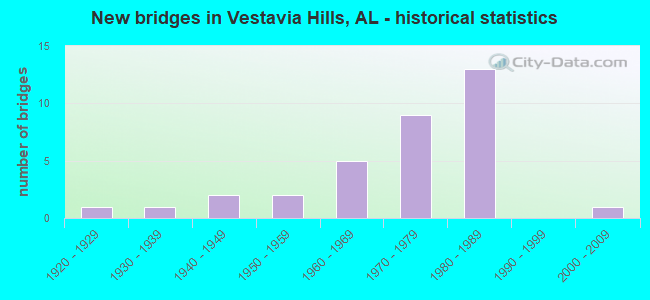
- New bridges - historical statistics
- 11920-1929
- 11930-1939
- 21940-1949
- 21950-1959
- 51960-1969
- 91970-1979
- 131980-1989
- 12000-2009
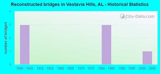
- Reconstructed bridges - Historical Statistics
- 31940-1949
- 01950-1959
- 01960-1969
- 01970-1979
- 31980-1989
- 01990-1999
- 12000-2009
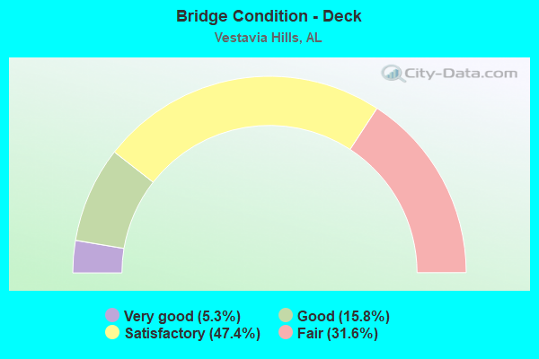
- Bridge Condition - Deck
- 5.3%Very good
- 15.8%Good
- 47.4%Satisfactory
- 31.6%Fair
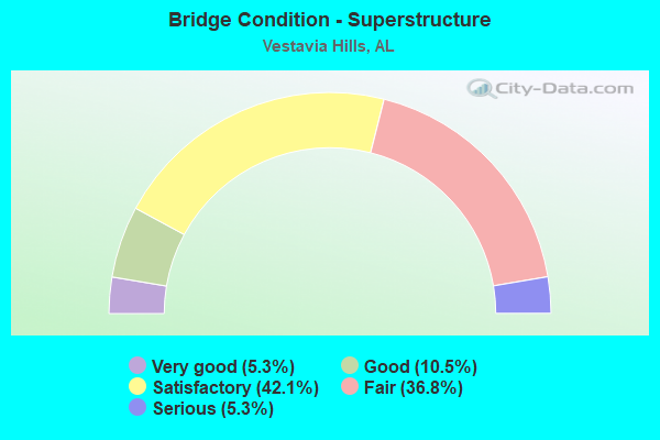
- Bridge Condition - Superstructure
- 5.3%Very good
- 10.5%Good
- 42.1%Satisfactory
- 36.8%Fair
- 5.3%Serious
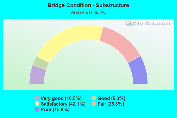
- Bridge Condition - Substructure
- 10.5%Very good
- 5.3%Good
- 42.1%Satisfactory
- 26.3%Fair
- 15.8%Poor
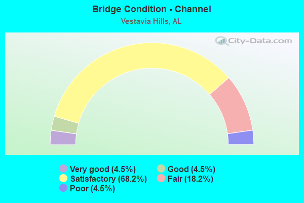
- Bridge Condition - Channel
- 4.5%Very good
- 4.5%Good
- 68.2%Satisfactory
- 18.2%Fair
- 4.5%Poor
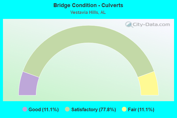
- Bridge Condition - Culverts
- 11.1%Good
- 77.8%Satisfactory
- 11.1%Fair
Find on map >> Show street view
Structure Number: 1307, Location: ROCKY RIDGE (Lat: 33.432800, Lng: -86.770350), Route carried "on" structure: County highway 113, Year Built: 1935, Status: Open, Structure Length: 1.98m (6.50ft), Average Daily Traffic: 10,930 (year 2021), Truck Traffic: 15%, Average Future Daily Traffic: 15,200 (year 2041), Features Intersected: SHADES CREEK, Facility Carried by Structure: ROCKY RIDGE ROAD
Minimum Vertical Clearance: 30+ m (98+ ft), Kilometerpoint: 0.010, Lanes on structure: 2, Owner: County Highway Agency, Approaching Roadway Width: 6.7m (22.0ft), Skew: 6 degrees, Material/Design: Concrete, Design/Construction: Tee Beam, Number Of Spans In Main Unit: 2, Length of Maximum Span: 10.1m (33.1ft), Curb or Sidewalk Widths: Left: 0.3m (1.0ft), Right: 0.3m (1.0ft), Curb-To-Curb Width: 7.6m (24.9ft), Out-to-Out Width: 8.2m (26.9ft)
Condition: Deck: Satisfactory, Superstructure: Fair, Substructure: Fair, Channel: Satisfactory, Operating Rating: 43.5 metric tons, Method Used To Determine Operating Rating: Field evaluation and documented engineering judgment, Inventory Rating: 32.7 metric tons, Method Used To Determine Inventory Rating: Field evaluation and documented engineering judgment, Structural Evaluation: Somewhat better than minimum adequacy, Deck Geometry: High priority of replacement, Waterway Adequacy: Equal to present minimum criteria, Approach Roadway Alignment: Better than present minimum criteria, Length Of Structure Improvement: 2.73m (8.96ft), Designated Inspection Frequency: Every 24 months, Inspection Date: November 2021, Bridge Improvement Cost: $486,000, Roadway Improvement Cost: $49,000, Total Project Cost: $535,000 ( Estimate for 2022), Deck Structure Type: Concrete Cast-file-Place, Wearing Surface/Protective System: Wearing Surface: Bituminous
Find on map >> Show street view
Structure Number: 3592, Location: 150' E HWY 280 CAHABA HTS (Lat: 33.453983, Lng: -86.743433), Route carried "on" structure: County highway , Year Built: 1950, Status: Posted for load, Structure Length: 5.65m (18.54ft), Average Daily Traffic: 323 (year 2021), Truck Traffic: 1%, Average Future Daily Traffic: 430 (year 2041), Design Load: H 15, Features Intersected: LITTLE SHADES CREEK, Facility Carried by Structure: BROOKWOOD GREEN TR
Minimum Vertical Clearance: 30+ m (98+ ft), Kilometerpoint: 0.010, Lanes on structure: 2, Owner: City or Municipal Highway Agency, Approaching Roadway Width: 6.5m (21.3ft), Material/Design: Concrete, Design/Construction: Tee Beam, Number Of Spans In Main Unit: 5, Length of Maximum Span: 10.4m (34.1ft), Curb or Sidewalk Widths: Left: 0.2m (0.7ft), Right: 0.2m (0.7ft), Curb-To-Curb Width: 7.3m (24.0ft), Out-to-Out Width: 8.4m (27.6ft)
Condition: Deck: Fair, Superstructure: Fair, Substructure: Poor, Channel: Satisfactory, Operating Rating: 9.1 metric tons, Method Used To Determine Operating Rating: Load Factor (LF), Inventory Rating: 7.3 metric tons, Method Used To Determine Inventory Rating: Load Factor (LF), Structural Evaluation: High priority of replacement, Deck Geometry: Somewhat better than minimum adequacy, Waterway Adequacy: Better than present minimum criteria, Approach Roadway Alignment: Equal to present minimum criteria, Bridge Posting: Required (Relationship of Operating Rating to Maximum Legal Load: > 39.9% below), Length Of Structure Improvement: 6.69m (21.95ft), Designated Inspection Frequency: Every 24 months, Other Special Inspection Frequency: Every 12 months, Inspection Date: July 2021, Other Special Inspection Date: July 2021, Bridge Improvement Cost: $1,239,000, Roadway Improvement Cost: $124,000, Total Project Cost: $1,363,000 ( Estimate for 2022), Deck Structure Type: Concrete Cast-file-Place, Wearing Surface/Protective System: Wearing Surface: Bituminous
Find on map >> Show street view
Structure Number: 3944, Location: ACTON (Lat: 33.426553, Lng: -86.733692), Route carried "on" structure: County highway ?????, Year Built: 1950, Status: Posted for load, Structure Length: 0.85m (2.79ft), Average Daily Traffic: 509 (year 2021), Truck Traffic: 1%, Average Future Daily Traffic: 700 (year 2041), Features Intersected: CABAHA RIVER TRIBUTARY, Facility Carried by Structure: OLD LOONEY MILL RD
Minimum Vertical Clearance: 30+ m (98+ ft), Kilometerpoint: 0.010, Lanes on structure: 1, Owner: County Highway Agency, Approaching Roadway Width: 5.5m (18.0ft), Material/Design: Steel, Design/Construction: Stringer/Multi-beam, Number Of Spans In Main Unit: 2, Length of Maximum Span: 3.7m (12.1ft), Curb-To-Curb Width: 7.4m (24.3ft), Out-to-Out Width: 7.7m (25.3ft)
Condition: Deck: Satisfactory, Superstructure: Fair, Substructure: Poor, Channel: Satisfactory, Operating Rating: 5.4 metric tons, Method Used To Determine Operating Rating: Load Factor (LF), Inventory Rating: 3.6 metric tons, Method Used To Determine Inventory Rating: Load Factor (LF), Structural Evaluation: High priority of replacement, Deck Geometry: Meets minimum limits, Waterway Adequacy: Equal to present minimum criteria, Approach Roadway Alignment: Equal to present minimum criteria, Bridge Posting: Required (Relationship of Operating Rating to Maximum Legal Load: > 39.9% below), Length Of Structure Improvement: 1.52m (4.99ft), Designated Inspection Frequency: Every 24 months, Other Special Inspection Frequency: Every 12 months, Inspection Date: July 2021, Other Special Inspection Date: July 2021, Bridge Improvement Cost: $260,000, Roadway Improvement Cost: $26,000, Total Project Cost: $286,000 ( Estimate for 2022), Deck Structure Type: Open Grating
Find on map >> Show street view
Structure Number: 4713, Location: .9 MI. NO. I-65 (Lat: 33.423300, Lng: -86.796400), Route carried "on" structure: US 31, Year Built: 1926, Year Reconstructed: 1954, Status: Open, Structure Length: 0.64m (2.10ft), Average Daily Traffic: 32,920 (year 2020), Truck Traffic: 5%, Average Future Daily Traffic: 42,288 (year 2040), Features Intersected: PATTON CREEK
Minimum Vertical Clearance: 30+ m (98+ ft), Kilometerpoint: 429.856, Lanes on structure: 8, Owner: State Highway Agency, Approaching Roadway Width: 30.5m (100.1ft), Skew: 10 degrees, Material/Design: Concrete, Design/Construction: Culvert, Number Of Spans In Main Unit: 2, Length of Maximum Span: 3.0m (9.8ft)
Condition: Channel: Satisfactory, Culverts: Satisfactory, Operating Rating: 88.9 metric tons, Method Used To Determine Operating Rating: Load Factor (LF), Inventory Rating: 67.5 metric tons, Method Used To Determine Inventory Rating: Load Factor (LF), Structural Evaluation: Equal to present minimum criteria, Waterway Adequacy: Equal to present minimum criteria, Approach Roadway Alignment: Equal to present desirable criteria, Length Of Structure Improvement: 1.26m (4.13ft), Designated Inspection Frequency: Every 24 months, Inspection Date: September 2020, Bridge Improvement Cost: $946,000, Roadway Improvement Cost: $95,000, Total Project Cost: $1,041,000 ( Estimate for 2022), Wearing Surface/Protective System: Wearing Surface: Bituminous
Find on map >> Show street view
Structure Number: 4728, Location: .6 MI. NO. I-65 (Lat: 33.416944, Lng: -86.802500), Route carried "on" structure: US 31, Year Built: 1942, Year Reconstructed: 1954, Status: Open, Structure Length: 2.41m (7.91ft), Average Daily Traffic: 16,460 (year 2021), Truck Traffic: 5%, Average Future Daily Traffic: 21,144 (year 2041), Design Load: H 20, Features Intersected: PATTON CREEK, Facility Carried by Structure: AL - 3 SOUTH
Minimum Vertical Clearance: 7.56m (24.80ft), Kilometerpoint: 429.508, Lanes on structure: 2, Owner: State Highway Agency, Approaching Roadway Width: 11.0m (36.1ft), Material/Design: Concrete, Design/Construction: Slab, Number Of Spans In Main Unit: 3, Length of Maximum Span: 7.9m (25.9ft), Curb-To-Curb Width: 11.0m (36.1ft), Out-to-Out Width: 12.5m (41.0ft)
Condition: Deck: Fair, Superstructure: Fair, Substructure: Fair, Channel: Fair, Operating Rating: 43.5 metric tons, Method Used To Determine Operating Rating: Field evaluation and documented engineering judgment, Inventory Rating: 32.7 metric tons, Method Used To Determine Inventory Rating: Field evaluation and documented engineering judgment, Structural Evaluation: Somewhat better than minimum adequacy, Deck Geometry: Equal to present minimum criteria, Waterway Adequacy: Somewhat better than minimum adequacy, Approach Roadway Alignment: Better than present minimum criteria, Length Of Structure Improvement: 3.27m (10.73ft), Designated Inspection Frequency: Every 24 months, Inspection Date: August 2020, Bridge Improvement Cost: $920,000, Roadway Improvement Cost: $92,000, Total Project Cost: $1,012,000 ( Estimate for 2022), Deck Structure Type: Concrete Cast-file-Place
Find on map >> Show street view
Structure Number: 4729, Location: .6 MI. NO. I-65 (Lat: 33.417361, Lng: -86.802583), Route carried "on" structure: US 31, Year Built: 1942, Year Reconstructed: 1954, Status: Open, Structure Length: 1.56m (5.12ft), Average Daily Traffic: 16,460 (year 2020), Truck Traffic: 5%, Average Future Daily Traffic: 21,144 (year 2040), Design Load: H 20, Features Intersected: PATTON CREEK
Minimum Vertical Clearance: 30+ m (98+ ft), Kilometerpoint: 429.508, Lanes on structure: 2, Owner: State Highway Agency, Approaching Roadway Width: 12.2m (40.0ft), Material/Design: Concrete, Design/Construction: Culvert, Number Of Spans In Main Unit: 4, Length of Maximum Span: 3.7m (12.1ft), Curb-To-Curb Width: 12.4m (40.7ft), Out-to-Out Width: 13.4m (44.0ft)
Condition: Channel: Satisfactory, Culverts: Satisfactory, Operating Rating: 50.2 metric tons, Method Used To Determine Operating Rating: Load Factor (LF), Inventory Rating: 30.0 metric tons, Method Used To Determine Inventory Rating: Load Factor (LF), Structural Evaluation: Equal to present minimum criteria, Deck Geometry: Better than present minimum criteria, Waterway Adequacy: Equal to present minimum criteria, Approach Roadway Alignment: Equal to present desirable criteria, Length Of Structure Improvement: 2.25m (7.38ft), Designated Inspection Frequency: Every 24 months, Inspection Date: August 2020, Bridge Improvement Cost: $662,000, Roadway Improvement Cost: $66,000, Total Project Cost: $728,000 ( Estimate for 2022)
Find on map >> Show street view
Structure Number: 7191, Location: 1/2 MI S ACTON ROAD (Lat: 33.425100, Lng: -86.736400), Route carried "on" structure: County highway 534, Year Built: 1960, Status: Posted for load, Structure Length: 1.01m (3.31ft), Average Daily Traffic: 875 (year 2020), Truck Traffic: 4%, Average Future Daily Traffic: 1,046 (year 2040), Features Intersected: CAHABA RIVER TRIBUTART, Facility Carried by Structure: CALDWELL MILL RD
Minimum Vertical Clearance: 30+ m (98+ ft), Kilometerpoint: 0.010, Lanes on structure: 2, Owner: County Highway Agency, Approaching Roadway Width: 5.6m (18.4ft), Material/Design: Steel continuous, Design/Construction: Stringer/Multi-beam, Number Of Spans In Main Unit: 2, Length of Maximum Span: 4.4m (14.4ft), Curb or Sidewalk Widths: Left: 0.2m (0.7ft), Right: 0.2m (0.7ft), Curb-To-Curb Width: 7.3m (24.0ft), Out-to-Out Width: 7.8m (25.6ft)
Condition: Deck: Fair, Superstructure: Serious, Substructure: Fair, Channel: Fair, Operating Rating: 2.7 metric tons, Method Used To Determine Operating Rating: Load Factor (LF), Inventory Rating: 1.8 metric tons, Method Used To Determine Inventory Rating: Load Factor (LF), Structural Evaluation: High priority of replacement, Deck Geometry: Meets minimum limits, Waterway Adequacy: Equal to present minimum criteria, Approach Roadway Alignment: Equal to present minimum criteria, Bridge Posting: Required (Relationship of Operating Rating to Maximum Legal Load: > 39.9% below), Length Of Structure Improvement: 1.68m (5.51ft), Designated Inspection Frequency: Every 24 months, Other Special Inspection Frequency: Every 3 months, Inspection Date: Febuary 2022, Other Special Inspection Date: Febuary 2022, Bridge Improvement Cost: $287,000, Roadway Improvement Cost: $29,000, Total Project Cost: $316,000 ( Estimate for 2022), Deck Structure Type: Concrete Cast-file-Place
Find on map >> Show street view
Structure Number: 739, Location: 300 FT. SO. JEFF CO LINE (Lat: 33.415883, Lng: -86.740264), Route carried "on" structure: County highway 29, Year Built: 1961, Status: Open, Structure Length: 6.86m (22.51ft), Average Daily Traffic: 16,152 (year 2021), Truck Traffic: 15%, Average Future Daily Traffic: 22,613 (year 2041), Design Load: H 20, Features Intersected: CAHABA RIVER
Minimum Vertical Clearance: 30+ m (98+ ft), Kilometerpoint: 0.010, Lanes on structure: 2, Owner: County Highway Agency, Approaching Roadway Width: 7.3m (24.0ft), Material/Design: Steel continuous, Design/Construction: Stringer/Multi-beam, Number Of Spans In Main Unit: 3, Length of Maximum Span: 31.1m (102.0ft), Curb-To-Curb Width: 7.3m (24.0ft), Out-to-Out Width: 8.8m (28.9ft)
Condition: Deck: Fair, Superstructure: Fair, Substructure: Fair, Channel: Poor, Operating Rating: 43.5 metric tons, Method Used To Determine Operating Rating: Load Factor (LF), Inventory Rating: 26.0 metric tons, Method Used To Determine Inventory Rating: Load Factor (LF), Structural Evaluation: Somewhat better than minimum adequacy, Deck Geometry: High priority of replacement, Waterway Adequacy: Equal to present desirable criteria, Approach Roadway Alignment: Somewhat better than minimum adequacy, Length Of Structure Improvement: 7.89m (25.89ft), Designated Inspection Frequency: Every 24 months, Inspection Date: October 2021, Bridge Improvement Cost: $1,569,000, Roadway Improvement Cost: $157,000, Total Project Cost: $1,726,000 ( Estimate for 2022), Deck Structure Type: Concrete Cast-file-Place
Find on map >> Show street view
Structure Number: 8823, Location: VESTRIDGE DR * US 31 (Lat: 33.433333, Lng: -86.783333), Route carried "on" structure: City street , Year Built: 1965, Status: Open, Structure Length: 0.64m (2.10ft), Average Daily Traffic: 3,100 (year 2020), Truck Traffic: 1%, Average Future Daily Traffic: 5,000 (year 2040), Design Load: H 15, Features Intersected: BRANCH, Facility Carried by Structure: VESTRIDGE DR
Minimum Vertical Clearance: 30+ m (98+ ft), Kilometerpoint: 0.100, Lanes on structure: 2, Owner: City or Municipal Highway Agency, Approaching Roadway Width: 6.4m (21.0ft), Material/Design: Concrete, Design/Construction: Culvert, Number Of Spans In Main Unit: 2, Length of Maximum Span: 3.0m (9.8ft)
Condition: Channel: Satisfactory, Culverts: Satisfactory, Operating Rating: 88.9 metric tons, Method Used To Determine Operating Rating: Load Factor (LF), Inventory Rating: 68.9 metric tons, Method Used To Determine Inventory Rating: Load Factor (LF), Structural Evaluation: Equal to present minimum criteria, Waterway Adequacy: Equal to present minimum criteria, Approach Roadway Alignment: Somewhat better than minimum adequacy, Length Of Structure Improvement: 1.26m (4.13ft), Designated Inspection Frequency: Every 24 months, Inspection Date: July 2020, Bridge Improvement Cost: $306,000, Roadway Improvement Cost: $31,000, Total Project Cost: $337,000 ( Estimate for 2022)
Find on map >> Show street view
Structure Number: 8933, Location: CAHABA HEIGHTS (Lat: 33.456961, Lng: -86.736894), Route carried "on" structure: County highway 501, Year Built: 1965, Status: Posted for load, Structure Length: 0.91m (2.99ft), Average Daily Traffic: 406 (year 2020), Truck Traffic: 2%, Average Future Daily Traffic: 530 (year 2040), Design Load: H 20, Features Intersected: LITTLE SHADES CREEK, Facility Carried by Structure: PIPE LINE ROAD
Minimum Vertical Clearance: 30+ m (98+ ft), Kilometerpoint: 0.010, Lanes on structure: 2, Owner: City or Municipal Highway Agency, Approaching Roadway Width: 6.8m (22.3ft), Material/Design: Concrete, Design/Construction: Channel Beam, Number Of Spans In Main Unit: 2, Length of Maximum Span: 4.0m (13.1ft), Curb or Sidewalk Widths: Left: 0.2m (0.7ft), Right: 0.2m (0.7ft), Curb-To-Curb Width: 8.3m (27.2ft), Out-to-Out Width: 8.7m (28.5ft)
Condition: Deck: Satisfactory, Superstructure: Satisfactory, Substructure: Satisfactory, Channel: Satisfactory, Operating Rating: 38.2 metric tons, Method Used To Determine Operating Rating: Load Factor (LF), Inventory Rating: 22.9 metric tons, Method Used To Determine Inventory Rating: Load Factor (LF), Structural Evaluation: Equal to present minimum criteria, Deck Geometry: Somewhat better than minimum adequacy, Waterway Adequacy: Equal to present minimum criteria, Approach Roadway Alignment: Equal to present minimum criteria, Bridge Posting: Required (Relationship of Operating Rating to Maximum Legal Load: 20.0 - 29.9% below), Length Of Structure Improvement: 1.59m (5.22ft), Designated Inspection Frequency: Every 24 months, Other Special Inspection Frequency: Every 12 months, Inspection Date: September 2020, Other Special Inspection Date: September 2021, Bridge Improvement Cost: $304,000, Roadway Improvement Cost: $30,000, Total Project Cost: $334,000 ( Estimate for 2022), Deck Structure Type: Concrete Precast Panels
Find on map >> Show street view
Structure Number: 10227, Location: 0.25 MI W ROCKY RIDGE RD (Lat: 33.425617, Lng: -86.775633), Route carried "on" structure: County highway , Year Built: 1970, Status: Open, Structure Length: 3.16m (10.37ft), Average Daily Traffic: 5,026 (year 2021), Truck Traffic: 8%, Average Future Daily Traffic: 6,835 (year 2041), Design Load: HS 20, Features Intersected: LITTLE SHADES CREEK, Facility Carried by Structure: MORGAN DR VESTAVIA
Minimum Vertical Clearance: 30+ m (98+ ft), Kilometerpoint: 0.010, Lanes on structure: 2, Owner: County Highway Agency, Approaching Roadway Width: 8.8m (28.9ft), Material/Design: Concrete, Design/Construction: Channel Beam, Number Of Spans In Main Unit: 3, Length of Maximum Span: 9.6m (31.5ft), Curb-To-Curb Width: 8.8m (28.9ft), Out-to-Out Width: 9.4m (30.8ft)
Condition: Deck: Good, Superstructure: Good, Substructure: Satisfactory, Channel: Fair, Operating Rating: 50.7 metric tons, Method Used To Determine Operating Rating: Load Factor (LF), Inventory Rating: 30.4 metric tons, Method Used To Determine Inventory Rating: Load Factor (LF), Structural Evaluation: Equal to present minimum criteria, Deck Geometry: High priority of replacement, Waterway Adequacy: Equal to present minimum criteria, Approach Roadway Alignment: Better than present minimum criteria, Length Of Structure Improvement: 4.02m (13.19ft), Designated Inspection Frequency: Every 24 months, Inspection Date: July 2021, Bridge Improvement Cost: $855,000, Roadway Improvement Cost: $86,000, Total Project Cost: $941,000 ( Estimate for 2022), Deck Structure Type: Concrete Precast Panels
Find on map >> Show street view
Structure Number: 10523, Location: 100 FT N JANNEBO (Lat: 33.421172, Lng: -86.776039), Route carried "on" structure: County highway , Year Built: 1971, Status: Posted for load, Structure Length: 1.98m (6.50ft), Average Daily Traffic: 75 (year 2021), Average Future Daily Traffic: 100 (year 2041), Features Intersected: LITTLE SHADES CREEK, Facility Carried by Structure: CHERRY TREE LANE
Minimum Vertical Clearance: 30+ m (98+ ft), Kilometerpoint: 0.010, Lanes on structure: 1, Owner: County Highway Agency, Approaching Roadway Width: 4.3m (14.1ft), Material/Design: Steel, Design/Construction: Stringer/Multi-beam, Number Of Spans In Main Unit: 3, Length of Maximum Span: 7.6m (24.9ft), Curb or Sidewalk Widths: Left: 0.2m (0.7ft), Right: 0.2m (0.7ft), Curb-To-Curb Width: 4.3m (14.1ft), Out-to-Out Width: 4.9m (16.1ft)
Condition: Deck: Good, Superstructure: Fair, Substructure: Satisfactory, Channel: Satisfactory, Operating Rating: 27.2 metric tons, Method Used To Determine Operating Rating: Load Factor (LF), Inventory Rating: 20.9 metric tons, Method Used To Determine Inventory Rating: Load Factor (LF), Structural Evaluation: Somewhat better than minimum adequacy, Deck Geometry: Equal to present minimum criteria, Waterway Adequacy: Equal to present minimum criteria, Approach Roadway Alignment: Better than present minimum criteria, Bridge Posting: Required (Relationship of Operating Rating to Maximum Legal Load: 10.0 - 19.9% below), Length Of Structure Improvement: 2.73m (8.96ft), Designated Inspection Frequency: Every 24 months, Other Special Inspection Frequency: Every 12 months, Inspection Date: May 2021, Other Special Inspection Date: May 2021, Bridge Improvement Cost: $299,000, Roadway Improvement Cost: $30,000, Total Project Cost: $329,000 ( Estimate for 2022), Deck Structure Type: Wood or Timber, Wearing Surface/Protective System: Wearing Surface: Wood or Timber
Find on map >> Show street view
Structure Number: 10685, Location: 0 . 8 MI S ALFORD AVE (Lat: 33.422356, Lng: -86.814242), Route carried "on" structure: Interstate 65, Year Built: 1972, Status: Open, Structure Length: 0.67m (2.20ft), Average Daily Traffic: 117,910 (year 2022), Truck Traffic: 10%, Average Future Daily Traffic: 149,383 (year 2042), Design Load: HS 20, Features Intersected: STREAM
Minimum Vertical Clearance: 30+ m (98+ ft), Kilometerpoint: 406.918, Lanes on structure: 3, Base Highway Network: Yes, Owner: State Highway Agency, Approaching Roadway Width: 17.1m (56.1ft), Skew: 4 degrees, Material/Design: Concrete, Design/Construction: Culvert, Number Of Spans In Main Unit: 2, Length of Maximum Span: 3.0m (9.8ft)
Condition: Channel: Satisfactory, Culverts: Satisfactory, Operating Rating: 88.9 metric tons, Method Used To Determine Operating Rating: Load Factor (LF), Inventory Rating: 88.9 metric tons, Method Used To Determine Inventory Rating: Load Factor (LF), Structural Evaluation: Equal to present minimum criteria, Waterway Adequacy: Better than present minimum criteria, Approach Roadway Alignment: Equal to present desirable criteria, Length Of Structure Improvement: 1.30m (4.27ft), Designated Inspection Frequency: Every 24 months, Inspection Date: January 2022, Bridge Improvement Cost: $1,764,000, Roadway Improvement Cost: $176,000, Total Project Cost: $1,940,000 ( Estimate for 2022), Deck Structure Type: Concrete Cast-file-Place
Find on map >> Show street view
Structure Number: 12205, Location: TANGLEWOOD DR @ VESTAVIA (Lat: 33.450000, Lng: -86.766667), Route carried "on" structure: City street , Year Built: 1979, Status: Open, Structure Length: 0.64m (2.10ft), Average Daily Traffic: 1,550 (year 2020), Truck Traffic: 1%, Average Future Daily Traffic: 2,000 (year 2040), Design Load: H 15, Features Intersected: BRANCH, Facility Carried by Structure: TANGLEWOOD DR
Minimum Vertical Clearance: 30+ m (98+ ft), Kilometerpoint: 0.100, Lanes on structure: 2, Owner: City or Municipal Highway Agency, Approaching Roadway Width: 18.0m (59.1ft), Material/Design: Concrete, Design/Construction: Culvert, Number Of Spans In Main Unit: 2, Length of Maximum Span: 3.0m (9.8ft)
Condition: Channel: Good, Culverts: Good, Operating Rating: 66.0 metric tons, Method Used To Determine Operating Rating: Load Factor (LF), Inventory Rating: 39.6 metric tons, Method Used To Determine Inventory Rating: Load Factor (LF), Structural Evaluation: Better than present minimum criteria, Waterway Adequacy: Equal to present minimum criteria, Approach Roadway Alignment: Equal to present desirable criteria, Length Of Structure Improvement: 1.26m (4.13ft), Designated Inspection Frequency: Every 24 months, Inspection Date: July 2020, Bridge Improvement Cost: $437,000, Roadway Improvement Cost: $44,000, Total Project Cost: $481,000 ( Estimate for 2022)
Find on map >> Show street view
Structure Number: 12302, Location: I459 * ACTON ROAD (Lat: 33.411936, Lng: -86.759369), Route carried "on" structure: Interstate 459, Year Built: 1980, Status: Open, Structure Length: 7.22m (23.69ft), Average Daily Traffic: 48,035 (year 2020), Truck Traffic: 10%, Average Future Daily Traffic: 60,736 (year 2040), Design Load: HS 20, Features Intersected: ACTON ROAD
Minimum Vertical Clearance: 30+ m (98+ ft), Kilometerpoint: 27.871, Lanes on structure: 3, Lanes under structure: 4, Base Highway Network: Yes, Owner: State Highway Agency, Approaching Roadway Width: 17.1m (56.1ft), Material/Design: Steel, Design/Construction: Stringer/Multi-beam, Number Of Spans In Main Unit: 1, Number Of Approach Spans: 2, Length of Maximum Span: 38.4m (126.0ft), Curb-To-Curb Width: 17.1m (56.1ft), Out-to-Out Width: 18.2m (59.7ft)
Condition: Deck: Satisfactory, Superstructure: Satisfactory, Substructure: Satisfactory, Operating Rating: 81.2 metric tons, Method Used To Determine Operating Rating: Load Factor (LF), Inventory Rating: 48.6 metric tons, Method Used To Determine Inventory Rating: Load Factor (LF), Structural Evaluation: Equal to present minimum criteria, Deck Geometry: Equal to present minimum criteria, Underclear: Superior to present desirable criteria, Approach Roadway Alignment: Equal to present desirable criteria, Length Of Structure Improvement: 8.25m (27.07ft), Designated Inspection Frequency: Every 24 months, Inspection Date: September 2020, Bridge Improvement Cost: $3,337,000, Roadway Improvement Cost: $334,000, Total Project Cost: $3,671,000 ( Estimate for 2022), Deck Structure Type: Concrete Cast-file-Place
Find on map >> Show street view
Structure Number: 12303, Location: I459 * ACTON ROAD (Lat: 33.412100, Lng: -86.758500), Route carried "on" structure: Interstate 459, Year Built: 1980, Status: Open, Structure Length: 7.56m (24.80ft), Average Daily Traffic: 48,035 (year 2020), Truck Traffic: 10%, Average Future Daily Traffic: 60,736 (year 2040), Design Load: HS 20, Features Intersected: ACTON ROAD
Minimum Vertical Clearance: 30+ m (98+ ft), Kilometerpoint: 27.871, Lanes on structure: 3, Lanes under structure: 4, Base Highway Network: Yes, Owner: State Highway Agency, Approaching Roadway Width: 17.1m (56.1ft), Material/Design: Steel, Design/Construction: Stringer/Multi-beam, Number Of Spans In Main Unit: 1, Number Of Approach Spans: 2, Length of Maximum Span: 40.2m (131.9ft), Curb-To-Curb Width: 17.1m (56.1ft), Out-to-Out Width: 18.0m (59.1ft)
Condition: Deck: Satisfactory, Superstructure: Satisfactory, Substructure: Satisfactory, Operating Rating: 81.2 metric tons, Method Used To Determine Operating Rating: Load Factor (LF), Inventory Rating: 48.6 metric tons, Method Used To Determine Inventory Rating: Load Factor (LF), Structural Evaluation: Equal to present minimum criteria, Deck Geometry: Equal to present minimum criteria, Underclear: Superior to present desirable criteria, Approach Roadway Alignment: Equal to present desirable criteria, Length Of Structure Improvement: 8.58m (28.15ft), Designated Inspection Frequency: Every 24 months, Inspection Date: September 2020, Bridge Improvement Cost: $3,471,000, Roadway Improvement Cost: $347,000, Total Project Cost: $3,818,000 ( Estimate for 2022), Deck Structure Type: Concrete Cast-file-Place
Find on map >> Show street view
Structure Number: 12304, Location: I459 * CAHABA RIVER RD. (Lat: 33.433808, Lng: -86.739633), Route carried "on" structure: Interstate 459, Year Built: 1980, Status: Open, Structure Length: 9.25m (30.35ft), Average Daily Traffic: 48,035 (year 2021), Truck Traffic: 10%, Average Future Daily Traffic: 60,736 (year 2041), Design Load: HS 20, Features Intersected: CAHABA RIVER RD.
Minimum Vertical Clearance: 30+ m (98+ ft), Kilometerpoint: 30.856, Lanes on structure: 3, Lanes under structure: 2, Base Highway Network: Yes, Owner: State Highway Agency, Approaching Roadway Width: 17.1m (56.1ft), Skew: 2 degrees, Material/Design: Steel continuous, Design/Construction: Stringer/Multi-beam, Number Of Spans In Main Unit: 3, Length of Maximum Span: 31.0m (101.7ft), Curb-To-Curb Width: 17.1m (56.1ft), Out-to-Out Width: 18.0m (59.1ft)
Condition: Deck: Fair, Superstructure: Satisfactory, Substructure: Good, Operating Rating: 44.8 metric tons, Method Used To Determine Operating Rating: Load Factor (LF), Inventory Rating: 34.4 metric tons, Method Used To Determine Inventory Rating: Load Factor (LF), Structural Evaluation: Equal to present minimum criteria, Deck Geometry: Equal to present minimum criteria, Underclear: Superior to present desirable criteria, Approach Roadway Alignment: Equal to present desirable criteria, Length Of Structure Improvement: 10.21m (33.50ft), Designated Inspection Frequency: Every 24 months, Inspection Date: March 2021, Bridge Improvement Cost: $4,131,000, Roadway Improvement Cost: $413,000, Total Project Cost: $4,544,000 ( Estimate for 2022), Deck Structure Type: Concrete Cast-file-Place
Find on map >> Show street view
Structure Number: 12305, Location: I459 * CAHABA RIVER RD. (Lat: 33.433611, Lng: -86.739444), Route carried "on" structure: Interstate 459, Year Built: 1980, Year Reconstructed: 2005, Status: Open, Structure Length: 9.25m (30.35ft), Average Daily Traffic: 48,035 (year 2021), Truck Traffic: 10%, Average Future Daily Traffic: 60,736 (year 2041), Design Load: HS 20, Features Intersected: CAHABA RIVER RD.
Minimum Vertical Clearance: 30+ m (98+ ft), Kilometerpoint: 30.856, Lanes on structure: 3, Lanes under structure: 2, Base Highway Network: Yes, Owner: State Highway Agency, Approaching Roadway Width: 17.1m (56.1ft), Material/Design: Steel continuous, Design/Construction: Stringer/Multi-beam, Number Of Spans In Main Unit: 3, Length of Maximum Span: 31.0m (101.7ft), Curb-To-Curb Width: 17.1m (56.1ft), Out-to-Out Width: 18.0m (59.1ft)
Condition: Deck: Satisfactory, Superstructure: Satisfactory, Substructure: Satisfactory, Operating Rating: 44.8 metric tons, Method Used To Determine Operating Rating: Load Factor (LF), Inventory Rating: 34.4 metric tons, Method Used To Determine Inventory Rating: Load Factor (LF), Structural Evaluation: Equal to present minimum criteria, Deck Geometry: Equal to present minimum criteria, Underclear: Superior to present desirable criteria, Approach Roadway Alignment: Equal to present desirable criteria, Length Of Structure Improvement: 10.21m (33.50ft), Designated Inspection Frequency: Every 24 months, Inspection Date: March 2021, Bridge Improvement Cost: $4,131,000, Roadway Improvement Cost: $413,000, Total Project Cost: $4,544,000 ( Estimate for 2022), Deck Structure Type: Concrete Cast-file-Place
Find on map >> Show street view
Structure Number: 12493, Location: I459 * CAHABA RIVER (Lat: 33.466619, Lng: -86.709389), Route carried "on" structure: Interstate 459, Year Built: 1981, Status: Open, Structure Length: 19.39m (63.62ft), Average Daily Traffic: 99,312 (year 2022), Truck Traffic: 14%, Average Future Daily Traffic: 179,368 (year 2042), Design Load: HS 20, Features Intersected: CAHABA RIVER
Minimum Vertical Clearance: 30+ m (98+ ft), Kilometerpoint: 35.464, Lanes on structure: 3, Base Highway Network: Yes, Owner: State Highway Agency, Approaching Roadway Width: 18.9m (62.0ft), Material/Design: Steel continuous, Design/Construction: Stringer/Multi-beam, Number Of Spans In Main Unit: 4, Number Of Approach Spans: 2, Length of Maximum Span: 45.7m (149.9ft), Curb-To-Curb Width: 17.1m (56.1ft), Out-to-Out Width: 17.9m (58.7ft)
Condition: Deck: Satisfactory, Superstructure: Satisfactory, Substructure: Poor, Channel: Satisfactory, Operating Rating: 62.1 metric tons, Method Used To Determine Operating Rating: Load Factor (LF), Inventory Rating: 37.1 metric tons, Method Used To Determine Inventory Rating: Load Factor (LF), Structural Evaluation: Meets minimum limits, Deck Geometry: Equal to present minimum criteria, Waterway Adequacy: Equal to present desirable criteria, Approach Roadway Alignment: Equal to present desirable criteria, Length Of Structure Improvement: 19.97m (65.52ft), Designated Inspection Frequency: Every 24 months, Other Special Inspection Frequency: Every 12 months, Inspection Date: January 2021, Other Special Inspection Date: January 2022, Bridge Improvement Cost: $7,941,000, Roadway Improvement Cost: $794,000, Total Project Cost: $8,735,000 ( Estimate for 2022), Deck Structure Type: Concrete Cast-file-Place
Find on map >> Show street view
Structure Number: 12494, Location: I459 * CAHABA RIVER (Lat: 33.466542, Lng: -86.709183), Route carried "on" structure: Interstate 459, Year Built: 1981, Status: Open, Structure Length: 19.39m (63.62ft), Average Daily Traffic: 99,312 (year 2021), Truck Traffic: 14%, Average Future Daily Traffic: 179,368 (year 2041), Design Load: HS 20, Features Intersected: CAHABA RIVER
Minimum Vertical Clearance: 30+ m (98+ ft), Kilometerpoint: 35.464, Lanes on structure: 3, Base Highway Network: Yes, Owner: State Highway Agency, Approaching Roadway Width: 18.9m (62.0ft), Material/Design: Steel continuous, Design/Construction: Stringer/Multi-beam, Number Of Spans In Main Unit: 4, Number Of Approach Spans: 2, Length of Maximum Span: 45.7m (149.9ft), Curb-To-Curb Width: 17.1m (56.1ft), Out-to-Out Width: 17.9m (58.7ft)
Condition: Deck: Satisfactory, Superstructure: Satisfactory, Substructure: Fair, Channel: Satisfactory, Operating Rating: 62.1 metric tons, Method Used To Determine Operating Rating: Load Factor (LF), Inventory Rating: 37.1 metric tons, Method Used To Determine Inventory Rating: Load Factor (LF), Structural Evaluation: Somewhat better than minimum adequacy, Deck Geometry: Equal to present minimum criteria, Waterway Adequacy: Equal to present desirable criteria, Approach Roadway Alignment: Equal to present desirable criteria, Length Of Structure Improvement: 19.97m (65.52ft), Designated Inspection Frequency: Every 24 months, Inspection Date: January 2021, Bridge Improvement Cost: $7,944,000, Roadway Improvement Cost: $794,000, Total Project Cost: $8,738,000 ( Estimate for 2022), Deck Structure Type: Concrete Cast-file-Place
Find on map >> Show street view
Structure Number: 14298, Location: .3 MI N JCT US 31 (Lat: 33.415667, Lng: -86.805550), Route carried "on" structure: County highway 501, Year Built: 1987, Status: Open, Structure Length: 2.13m (6.99ft), Average Daily Traffic: 20,885 (year 2021), Truck Traffic: 15%, Average Future Daily Traffic: 29,200 (year 2041), Design Load: HS 20, Features Intersected: PATTON CREEK, Facility Carried by Structure: COLUMBIANA ROAD
Minimum Vertical Clearance: 30+ m (98+ ft), Kilometerpoint: 0.100, Lanes on structure: 5, Owner: County Highway Agency, Approaching Roadway Width: 13.4m (44.0ft), Skew: 4 degrees, Material/Design: Concrete continuous, Design/Construction: Culvert, Number Of Spans In Main Unit: 4, Length of Maximum Span: 5.3m (17.4ft)
Condition: Channel: Satisfactory, Culverts: Satisfactory, Operating Rating: 88.9 metric tons, Method Used To Determine Operating Rating: Load Factor (LF), Inventory Rating: 88.9 metric tons, Method Used To Determine Inventory Rating: Load Factor (LF), Structural Evaluation: Equal to present minimum criteria, Waterway Adequacy: Better than present minimum criteria, Approach Roadway Alignment: Equal to present desirable criteria, Length Of Structure Improvement: 2.91m (9.55ft), Designated Inspection Frequency: Every 24 months, Inspection Date: January 2021, Bridge Improvement Cost: $2,019,000, Roadway Improvement Cost: $202,000, Total Project Cost: $2,221,000 ( Estimate for 2022)
Find on map >> Show street view
Structure Number: 14418, Location: HOOVER INTERCHANGE (Lat: 33.412003, Lng: -86.805656), Route carried "on" structure: Interstate 65, Year Built: 1972, Year Reconstructed: 1988, Status: Open, Structure Length: 9.69m (31.79ft), Average Daily Traffic: 117,910 (year 2020), Truck Traffic: 10%, Average Future Daily Traffic: 149,383 (year 2040), Design Load: HS 20, Features Intersected: AL - 3
Minimum Vertical Clearance: 30+ m (98+ ft), Kilometerpoint: 405.474, Lanes on structure: 8, Lanes under structure: 7, Base Highway Network: Yes, Owner: State Highway Agency, Approaching Roadway Width: 41.1m (134.8ft), Skew: 30 degrees, Material/Design: Steel continuous, Design/Construction: Stringer/Multi-beam, Number Of Spans In Main Unit: 3, Length of Maximum Span: 43.3m (142.1ft), Curb-To-Curb Width: 39.3m (128.9ft), Out-to-Out Width: 41.1m (134.8ft)
Condition: Deck: Satisfactory, Superstructure: Satisfactory, Substructure: Satisfactory, Operating Rating: 59.7 metric tons, Method Used To Determine Operating Rating: Load Factor (LF), Inventory Rating: 35.7 metric tons, Method Used To Determine Inventory Rating: Load Factor (LF), Structural Evaluation: Equal to present minimum criteria, Deck Geometry: Superior to present desirable criteria, Underclear: Superior to present desirable criteria, Approach Roadway Alignment: Equal to present desirable criteria, Length Of Structure Improvement: 10.64m (34.91ft), Designated Inspection Frequency: Every 24 months, Inspection Date: July 2020, Bridge Improvement Cost: $9,772,000, Roadway Improvement Cost: $977,000, Total Project Cost: $10,749,000 ( Estimate for 2022), Deck Structure Type: Concrete Cast-file-Place
Find on map >> Show street view
Structure Number: 14419, Location: .1 MI. NO. HOOVER INTER (Lat: 33.412819, Lng: -86.807611), Route carried "on" structure: Interstate 65, Year Built: 1972, Year Reconstructed: 1988, Status: Open, Structure Length: 2.14m (7.02ft), Average Daily Traffic: 117,910 (year 2022), Truck Traffic: 10%, Average Future Daily Traffic: 149,383 (year 2042), Design Load: HS 20, Features Intersected: PATTONS CK
Minimum Vertical Clearance: 30+ m (98+ ft), Kilometerpoint: 405.651, Lanes on structure: 9, Base Highway Network: Yes, Owner: State Highway Agency, Approaching Roadway Width: 57.9m (190.0ft), Skew: 2 degrees, Material/Design: Concrete, Design/Construction: Culvert, Number Of Spans In Main Unit: 5, Length of Maximum Span: 3.7m (12.1ft)
Condition: Channel: Satisfactory, Culverts: Fair, Operating Rating: 88.9 metric tons, Method Used To Determine Operating Rating: Load Factor (LF), Inventory Rating: 88.9 metric tons, Method Used To Determine Inventory Rating: Load Factor (LF), Structural Evaluation: Somewhat better than minimum adequacy, Waterway Adequacy: Superior to present desirable criteria, Approach Roadway Alignment: Better than present minimum criteria, Length Of Structure Improvement: 2.93m (9.61ft), Designated Inspection Frequency: Every 24 months, Inspection Date: January 2022, Bridge Improvement Cost: $10,374,000, Roadway Improvement Cost: $1,037,000, Total Project Cost: $11,411,000 ( Estimate for 2022)
Find on map >> Show street view
Structure Number: 1442, Location: I65 * TYLER ROAD (Lat: 33.413500, Lng: -86.809400), Route carried "on" structure: Interstate 65, Year Built: 1972, Year Reconstructed: 1988, Status: Open, Structure Length: 5.79m (19.00ft), Average Daily Traffic: 117,910 (year 2020), Truck Traffic: 10%, Average Future Daily Traffic: 149,383 (year 2040), Design Load: HS 20, Features Intersected: TYLER ROAD
Minimum Vertical Clearance: 30+ m (98+ ft), Kilometerpoint: 405.976, Lanes on structure: 7, Lanes under structure: 2, Base Highway Network: Yes, Owner: State Highway Agency, Approaching Roadway Width: 42.4m (139.1ft), Skew: 31 degrees, Material/Design: Steel, Design/Construction: Stringer/Multi-beam, Number Of Spans In Main Unit: 3, Length of Maximum Span: 23.5m (77.1ft), Curb-To-Curb Width: 39.3m (128.9ft), Out-to-Out Width: 39.6m (129.9ft)
Condition: Deck: Fair, Superstructure: Fair, Substructure: Satisfactory, Operating Rating: 75.9 metric tons, Method Used To Determine Operating Rating: Load Factor (LF), Inventory Rating: 45.4 metric tons, Method Used To Determine Inventory Rating: Load Factor (LF), Structural Evaluation: Somewhat better than minimum adequacy, Deck Geometry: Superior to present desirable criteria, Underclear: Equal to present minimum criteria, Approach Roadway Alignment: Better than present minimum criteria, Length Of Structure Improvement: 6.83m (22.41ft), Designated Inspection Frequency: Every 24 months, Inspection Date: April 2020, Bridge Improvement Cost: $6,087,000, Roadway Improvement Cost: $609,000, Total Project Cost: $6,696,000 ( Estimate for 2022), Deck Structure Type: Concrete Cast-file-Place
Find on map >> Show street view
Structure Number: 14668, Location: JCT DOLLY RIDGE RD (Lat: 33.456647, Lng: -86.737242), Route carried "on" structure: County highway 523, Year Built: 1988, Status: Open, Structure Length: 0.92m (3.02ft), Average Daily Traffic: 15,061 (year 2022), Truck Traffic: 5%, Average Future Daily Traffic: 21,100 (year 2042), Design Load: HS 20, Features Intersected: LITTLE SHADES CREEK, Facility Carried by Structure: CAHABA HEIGHTS RD
Minimum Vertical Clearance: 30+ m (98+ ft), Kilometerpoint: 0.010, Lanes on structure: 2, Owner: City or Municipal Highway Agency, Approaching Roadway Width: 9.8m (32.2ft), Skew: 2 degrees, Material/Design: Concrete, Design/Construction: Culvert, Number Of Spans In Main Unit: 3, Length of Maximum Span: 2.7m (8.9ft)
Condition: Channel: Satisfactory, Culverts: Satisfactory, Operating Rating: 56.8 metric tons, Method Used To Determine Operating Rating: Load Factor (LF), Inventory Rating: 34.0 metric tons, Method Used To Determine Inventory Rating: Load Factor (LF), Structural Evaluation: Equal to present minimum criteria, Waterway Adequacy: Better than present minimum criteria, Approach Roadway Alignment: Better than present minimum criteria, Length Of Structure Improvement: 1.58m (5.18ft), Designated Inspection Frequency: Every 24 months, Inspection Date: Febuary 2022, Bridge Improvement Cost: $1,463,000, Roadway Improvement Cost: $146,000, Total Project Cost: $1,609,000 ( Estimate for 2022)
Find on map >> Show street view
Structure Number: 15799, Location: .1 MI E I459 N (Lat: 33.485400, Lng: -86.708367), Route carried "on" structure: County highway , Year Built: 1984, Status: Open, Structure Length: 9.47m (31.07ft), Average Daily Traffic: 2,625 (year 2021), Truck Traffic: 10%, Average Future Daily Traffic: 3,600 (year 2041), Design Load: HS 20, Features Intersected: OLD OVERTON RD;CAHABA R, Facility Carried by Structure: LIBERTY PARKWAY
Minimum Vertical Clearance: 30+ m (98+ ft), Kilometerpoint: 0.000, Lanes on structure: 5, Lanes under structure: 2, Owner: City or Municipal Highway Agency, Approaching Roadway Width: 19.2m (63.0ft), Material/Design: Prestressed concrete, Design/Construction: Stringer/Multi-beam, Number Of Spans In Main Unit: 4, Length of Maximum Span: 22.9m (75.1ft), Curb or Sidewalk Widths: Left: 0.3m (1.0ft), Right: 0.3m (1.0ft), Curb-To-Curb Width: 19.2m (63.0ft), Out-to-Out Width: 20.4m (66.9ft)
Condition: Deck: Good, Superstructure: Good, Substructure: Very good, Channel: Satisfactory, Operating Rating: 70.9 metric tons, Method Used To Determine Operating Rating: Load Factor (LF), Inventory Rating: 33.9 metric tons, Method Used To Determine Inventory Rating: Load Factor (LF), Structural Evaluation: Better than present minimum criteria, Deck Geometry: Meets minimum limits, Underclear: Superior to present desirable criteria, Waterway Adequacy: Better than present minimum criteria, Approach Roadway Alignment: Better than present minimum criteria, Length Of Structure Improvement: 10.42m (34.19ft), Designated Inspection Frequency: Every 24 months, Underwater Inspection Frequency: Every 48 months, Inspection Date: July 2021, Underwater Inspection Date: July 2021, Bridge Improvement Cost: $4,717,000, Roadway Improvement Cost: $472,000, Total Project Cost: $5,189,000 ( Estimate for 2022), Deck Structure Type: Concrete Cast-file-Place
Find on map >> Show street view
Structure Number: 17699, Location: 1.5 MI SO MORGAN DRIVE (Lat: 33.410119, Lng: -86.780886), Route carried "on" structure: County highway 528, Year Built: 2001, Status: Open, Structure Length: 5.00m (16.40ft), Average Daily Traffic: 13,400 (year 2021), Truck Traffic: 1%, Average Future Daily Traffic: 15,560 (year 2041), Design Load: HS 20, Features Intersected: LITTLE SHADES CREEK, Facility Carried by Structure: ROCKY RIDGE ROAD
Minimum Vertical Clearance: 30+ m (98+ ft), Kilometerpoint: 0.000, Lanes on structure: 2, Owner: County Highway Agency, Approaching Roadway Width: 10.0m (32.8ft), Skew: 3 degrees, Material/Design: Prestressed concrete, Design/Construction: Stringer/Multi-beam, Number Of Spans In Main Unit: 3, Length of Maximum Span: 23.5m (77.1ft), Curb-To-Curb Width: 12.3m (40.4ft), Out-to-Out Width: 13.0m (42.7ft)
Condition: Deck: Very good, Superstructure: Very good, Substructure: Very good, Channel: Very good, Operating Rating: 54.6 metric tons, Method Used To Determine Operating Rating: Load Factor (LF), Inventory Rating: 43.5 metric tons, Method Used To Determine Inventory Rating: Load Factor (LF), Structural Evaluation: Equal to present desirable criteria, Deck Geometry: Somewhat better than minimum adequacy, Waterway Adequacy: Equal to present desirable criteria, Approach Roadway Alignment: Better than present minimum criteria, Length Of Structure Improvement: 6.02m (19.75ft), Designated Inspection Frequency: Every 24 months, Inspection Date: August 2021, Bridge Improvement Cost: $1,734,000, Roadway Improvement Cost: $173,000, Total Project Cost: $1,907,000 ( Estimate for 2019), Deck Structure Type: Concrete Cast-file-Place
Find on map >> Show street view
Structure Number: 19819, Location: 0.25MI FROM ROCKY RIDGE R (Lat: 33.460075, Lng: -86.771822), Route carried "on" structure: City street , Year Built: 1960, Status: Open, Structure Length: 0.62m (2.03ft), Average Daily Traffic: 300 (year 2020), Average Future Daily Traffic: 420 (year 2040), Design Load: HS 20, Features Intersected: BRANCH, Facility Carried by Structure: TANGLEWOOD CIRCLE
Minimum Vertical Clearance: 30+ m (98+ ft), Kilometerpoint: 0.000, Lanes on structure: 2, Owner: City or Municipal Highway Agency, Approaching Roadway Width: 7.3m (24.0ft), Skew: 3 degrees, Material/Design: Concrete, Design/Construction: Culvert, Number Of Spans In Main Unit: 2, Length of Maximum Span: 3.2m (10.5ft), Curb-To-Curb Width: 9.1m (29.9ft), Out-to-Out Width: 14.6m (47.9ft)
Condition: Channel: Fair, Culverts: Satisfactory, Operating Rating: 55.5 metric tons, Method Used To Determine Operating Rating: Load Factor (LF), Inventory Rating: 33.3 metric tons, Method Used To Determine Inventory Rating: Load Factor (LF), Structural Evaluation: Equal to present minimum criteria, Deck Geometry: Equal to present minimum criteria, Waterway Adequacy: Equal to present desirable criteria, Approach Roadway Alignment: Equal to present desirable criteria, Length Of Structure Improvement: 1.24m (4.07ft), Designated Inspection Frequency: Every 24 months, Inspection Date: July 2020, Bridge Improvement Cost: $344,000, Roadway Improvement Cost: $34,000, Total Project Cost: $378,000 ( Estimate for 2022)
Find on map >> Show street view
Structure Number: 12302, Location: I459 * ACTON ROAD (Lat: 33.411936, Lng: -86.759369), Route carried "under" structure: Business City street , Year Built: 1980, Structure Length: 0. m, Average Daily Traffic: 10,000 (year 2020), Features Intersected: ACTON ROAD, Facility Carried by Structure: I - 459 SOUTH
Minimum Vertical Clearance: 30+ m (98+ ft), Kilometerpoint: 0.161, Lanes on structure: 3, Lanes under structure: 4, Material/Design: Steel, Design/Construction: Stringer/Multi-beam, Length of Maximum Span: 38.4m (126.0ft)
Find on map >> Show street view
Structure Number: 12303, Location: I459 * ACTON ROAD (Lat: 33.412100, Lng: -86.758500), Route carried "under" structure: City street , Year Built: 1980, Structure Length: 0. m, Average Daily Traffic: 1,000 (year 2020), Truck Traffic: 8%, Features Intersected: ACTON ROAD, Facility Carried by Structure: I - 459 NORTH
Minimum Vertical Clearance: 5.28m (17.32ft), Kilometerpoint: 17.308, Lanes on structure: 3, Lanes under structure: 4, Material/Design: Steel, Design/Construction: Stringer/Multi-beam, Length of Maximum Span: 40.2m (131.9ft)
Find on map >> Show street view
Structure Number: 12304, Location: I459 * CAHABA RIVER RD. (Lat: 33.433808, Lng: -86.739633), Route carried "under" structure: City street , Year Built: 1980, Structure Length: 0. m, Average Daily Traffic: 700 (year 2003), Truck Traffic: 2%, Features Intersected: CAHABA RIVER RD., Facility Carried by Structure: I459
Minimum Vertical Clearance: 11.49m (37.70ft), Kilometerpoint: 19.190, Lanes on structure: 3, Lanes under structure: 2, Material/Design: Steel continuous, Design/Construction: Stringer/Multi-beam, Length of Maximum Span: 31.0m (101.7ft)
Find on map >> Show street view
Structure Number: 12305, Location: I459 * CAHABA RIVER RD. (Lat: 33.433611, Lng: -86.739444), Route carried "under" structure: City street , Year Built: 1980, Structure Length: 0. m, Average Daily Traffic: 1,000 (year 2003), Truck Traffic: 8%, Features Intersected: CAHABA RIVER RD., Facility Carried by Structure: I459
Minimum Vertical Clearance: 11.49m (37.70ft), Kilometerpoint: 19.190, Lanes on structure: 3, Lanes under structure: 2, Material/Design: Steel continuous, Design/Construction: Stringer/Multi-beam, Length of Maximum Span: 31.0m (101.7ft)
Find on map >> Show street view
Structure Number: 14418, Location: HOOVER INTERCHANGE (Lat: 33.412003, Lng: -86.805656), Route carried "under" structure: US 31, Year Built: 1972, Structure Length: 0. m, Average Daily Traffic: 37,260 (year 2020), Truck Traffic: 5%, Features Intersected: AL - 3, Facility Carried by Structure: I65
Minimum Vertical Clearance: 5.15m (16.90ft), Kilometerpoint: 428.488, Lanes on structure: 8, Lanes under structure: 7, Material/Design: Steel continuous, Design/Construction: Stringer/Multi-beam, Length of Maximum Span: 43.3m (142.1ft)
Find on map >> Show street view
Structure Number: 1442, Location: I65 * TYLER ROAD (Lat: 33.413500, Lng: -86.809400), Route carried "under" structure: ServiceCity street , Year Built: 1972, Structure Length: 0. m, Average Daily Traffic: 3,500 (year 2002), Truck Traffic: 2%, Features Intersected: TYLER ROAD, Facility Carried by Structure: I - 65
Minimum Vertical Clearance: 5.11m (16.77ft), Kilometerpoint: 0.161, Lanes on structure: 7, Lanes under structure: 2, Material/Design: Steel, Design/Construction: Stringer/Multi-beam, Length of Maximum Span: 23.5m (77.1ft)