Bridge Statistics for Vero Beach, Florida (FL)
Condition, Traffic, Stress, Structural Evaluation, Project Costs
- National Bridge Inventory (NBI) Statistics
- 38Number of bridges
- 1,165ft / 355mTotal length
- 293,890Total average daily traffic
- 20,240Total average daily truck traffic
- 576,975Total future (year 2040) average daily traffic
- National Bridge Inventory (NBI) Registered Bridges for Vero Beach
- No street view available for this location
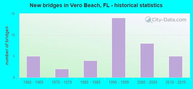
- New bridges - historical statistics
- 51960-1969
- 21970-1979
- 41980-1989
- 141990-1999
- 82000-2009
- 52010-2019

- Reconstructed bridges - Historical Statistics
- 21980-1989
- 01990-1999
- 12000-2009


- Bridge Condition - Deck
- 2.8%Excellent
- 16.7%Very good
- 44.4%Good
- 13.9%Satisfactory
- 19.4%Fair
- 2.8%Poor

- Bridge Condition - Superstructure
- 2.8%Excellent
- 19.4%Very good
- 41.7%Good
- 11.1%Satisfactory
- 19.4%Fair
- 5.6%Poor

- Bridge Condition - Substructure
- 2.8%Excellent
- 19.4%Very good
- 58.3%Good
- 11.1%Satisfactory
- 8.3%Fair

- Bridge Condition - Channel
- 2.6%Excellent
- 23.7%Very good
- 63.2%Good
- 10.5%Satisfactory

- Bridge Condition - Culverts
- 50.0%Good
- 50.0%Satisfactory
Find on map >> Show street view
Structure Number: 880018, Location: 0.7 MILE NORTH OF SR-60 (Lat: 27.650039, Lng: -80.495603), Route carried "on" structure: County highway 619, Year Built: 1962, Year Reconstructed: 1980, Status: Open, Structure Length: 1.37m (4.49ft), Average Daily Traffic: 2,300 (year 2022), Truck Traffic: 10%, Average Future Daily Traffic: 3,991 (year 2042), Design Load: H 10, Features Intersected: RELIEF CANAL
Minimum Vertical Clearance: 30+ m (98+ ft), Kilometerpoint: 6.883, Lanes on structure: 2, Owner: County Highway Agency, Approaching Roadway Width: 7.3m (24.0ft), Material/Design: Concrete, Design/Construction: Slab, Number Of Spans In Main Unit: 3, Length of Maximum Span: 4.6m (15.1ft), Curb or Sidewalk Widths: Left: 0.1m (0.3ft), Right: 0.1m (0.3ft), Curb-To-Curb Width: 7.3m (24.0ft), Out-to-Out Width: 7.7m (25.3ft)
Condition: Deck: Satisfactory, Superstructure: Satisfactory, Substructure: Satisfactory, Channel: Satisfactory, Operating Rating: 44.0 metric tons, Method Used To Determine Operating Rating: Load Factor (LF), Inventory Rating: 26.4 metric tons, Method Used To Determine Inventory Rating: Load Factor (LF), Structural Evaluation: Equal to present minimum criteria, Deck Geometry: High priority of replacement, Waterway Adequacy: Better than present minimum criteria, Approach Roadway Alignment: Equal to present desirable criteria, Designated Inspection Frequency: Every 24 months, Inspection Date: January 2022, Deck Structure Type: Concrete Precast Panels, Wearing Surface/Protective System: Wearing Surface: Bituminous
Find on map >> Show street view
Structure Number: 880019, Location: 1MI NORTH OF SR-60 (Lat: 27.653697, Lng: -80.495567), Route carried "on" structure: County highway 619, Year Built: 1962, Status: Open, Structure Length: 1.37m (4.49ft), Average Daily Traffic: 2,300 (year 2022), Truck Traffic: 9%, Average Future Daily Traffic: 3,990 (year 2042), Design Load: H 10, Features Intersected: RELIEF CANAL
Minimum Vertical Clearance: 30+ m (98+ ft), Kilometerpoint: 7.284, Lanes on structure: 2, Owner: County Highway Agency, Approaching Roadway Width: 7.3m (24.0ft), Material/Design: Concrete, Design/Construction: Slab, Number Of Spans In Main Unit: 3, Length of Maximum Span: 4.6m (15.1ft), Curb or Sidewalk Widths: Left: 0.1m (0.3ft), Right: 0.1m (0.3ft), Curb-To-Curb Width: 7.3m (24.0ft), Out-to-Out Width: 7.7m (25.3ft)
Condition: Deck: Satisfactory, Superstructure: Satisfactory, Substructure: Satisfactory, Channel: Satisfactory, Operating Rating: 44.0 metric tons, Method Used To Determine Operating Rating: Load Factor (LF), Inventory Rating: 26.4 metric tons, Method Used To Determine Inventory Rating: Load Factor (LF), Structural Evaluation: Equal to present minimum criteria, Deck Geometry: High priority of replacement, Waterway Adequacy: Equal to present desirable criteria, Approach Roadway Alignment: Equal to present desirable criteria, Designated Inspection Frequency: Every 24 months, Inspection Date: January 2022, Deck Structure Type: Concrete Precast Panels, Wearing Surface/Protective System: Wearing Surface: Bituminous
Find on map >> Show street view
Structure Number: 88002, Location: 1.1MI N OF SR-60 (Lat: 27.657369, Lng: -80.495531), Route carried "on" structure: County highway 619, Year Built: 1965, Year Reconstructed: 1980, Status: Open, Structure Length: 1.37m (4.49ft), Average Daily Traffic: 1,650 (year 2022), Truck Traffic: 10%, Average Future Daily Traffic: 1,980 (year 2042), Design Load: H 10, Features Intersected: RELIEF CANAL
Minimum Vertical Clearance: 30+ m (98+ ft), Kilometerpoint: 7.691, Lanes on structure: 2, Owner: County Highway Agency, Approaching Roadway Width: 7.0m (23.0ft), Material/Design: Concrete, Design/Construction: Slab, Number Of Spans In Main Unit: 3, Length of Maximum Span: 4.6m (15.1ft), Curb or Sidewalk Widths: Left: 0.1m (0.3ft), Right: 0.1m (0.3ft), Curb-To-Curb Width: 7.3m (24.0ft), Out-to-Out Width: 7.7m (25.3ft)
Condition: Deck: Satisfactory, Superstructure: Satisfactory, Substructure: Fair, Channel: Good, Operating Rating: 42.7 metric tons, Method Used To Determine Operating Rating: Load Factor (LF), Inventory Rating: 25.7 metric tons, Method Used To Determine Inventory Rating: Load Factor (LF), Structural Evaluation: Somewhat better than minimum adequacy, Deck Geometry: Meets minimum limits, Waterway Adequacy: Better than present minimum criteria, Approach Roadway Alignment: Equal to present desirable criteria, Designated Inspection Frequency: Every 24 months, Inspection Date: January 2022, Deck Structure Type: Concrete Precast Panels, Wearing Surface/Protective System: Wearing Surface: Bituminous
Find on map >> Show street view
Structure Number: 88003, Location: 2.25Mi. W of US-1 (Lat: 27.638611, Lng: -80.432778), Route carried "on" structure: State highway 60, Year Built: 1971, Year Reconstructed: 2005, Status: Open, Structure Length: 12.68m (41.60ft), Average Daily Traffic: 28,000 (year 2020), Truck Traffic: 7%, Average Future Daily Traffic: 48,580 (year 2042), Design Load: HS 20, Features Intersected: Main Canal
Minimum Vertical Clearance: 30+ m (98+ ft), Kilometerpoint: 44.933, Lanes on structure: 6, Base Highway Network: Yes, Owner: State Highway Agency, Approaching Roadway Width: 25.6m (84.0ft), Skew: 26 degrees, Material/Design: Prestressed concrete, Design/Construction: Stringer/Multi-beam, Number Of Spans In Main Unit: 6, Length of Maximum Span: 21.3m (69.9ft), Curb or Sidewalk Widths: Left: 2.0m (6.6ft), Right: 2.0m (6.6ft), Curb-To-Curb Width: 26.1m (85.6ft), Out-to-Out Width: 30.8m (101.0ft)
Condition: Deck: Good, Superstructure: Good, Substructure: Satisfactory, Channel: Good, Operating Rating: 65.4 metric tons, Method Used To Determine Operating Rating: Load Factor (LF), Inventory Rating: 39.1 metric tons, Method Used To Determine Inventory Rating: Load Factor (LF), Structural Evaluation: Equal to present minimum criteria, Deck Geometry: Equal to present minimum criteria, Waterway Adequacy: Superior to present desirable criteria, Approach Roadway Alignment: Equal to present desirable criteria, Designated Inspection Frequency: Every 24 months, Underwater Inspection Frequency: Every 24 months, Inspection Date: April 2020, Underwater Inspection Date: April 2020, Deck Structure Type: Concrete Cast-file-Place
Find on map >> Show street view
Structure Number: 880077, Location: 0.4 Mi. W of SR-A1A (Lat: 27.632333, Lng: -80.371333), Route carried "on" structure: State highway 656, Year Built: 1979, Status: Open, Structure Length: 144.19m (473.06ft), Average Daily Traffic: 23,500 (year 2022), Truck Traffic: 6%, Average Future Daily Traffic: 40,772 (year 2042), Design Load: HS 20, Features Intersected: Intracoastal Waterway
Minimum Vertical Clearance: 30+ m (98+ ft), Kilometerpoint: 1.149, Lanes on structure: 4, Owner: State Highway Agency, Approaching Roadway Width: 24.8m (81.4ft), Skew: 30 degrees, Navigation Control: Yes ( Vertical Clearance: 19.8m (65.0ft), Horizontal Clearance: 27.4m (89.9ft)), Material/Design: Prestressed concrete, Design/Construction: Stringer/Multi-beam, Number Of Spans In Main Unit: 59, Number Of Approach Spans: 5, Length of Maximum Span: 43.0m (141.1ft), Curb-To-Curb Width: 24.2m (79.4ft), Out-to-Out Width: 25.8m (84.6ft)
Condition: Deck: Satisfactory, Superstructure: Poor, Substructure: Good, Channel: Good, Operating Rating: 49.4 metric tons, Method Used To Determine Operating Rating: Load and Resistance Factor (LRFR), Inventory Rating: 38.2 metric tons, Method Used To Determine Inventory Rating: Load and Resistance Factor (LRFR), Structural Evaluation: Meets minimum limits, Deck Geometry: Superior to present desirable criteria, Waterway Adequacy: Superior to present desirable criteria, Approach Roadway Alignment: Equal to present desirable criteria, Designated Inspection Frequency: Every 24 months, Underwater Inspection Frequency: Every 24 months, Other Special Inspection Frequency: Every 2 months, Inspection Date: November 2020, Underwater Inspection Date: November 2020, Other Special Inspection Date: January 2022, Deck Structure Type: Concrete Precast Panels
Find on map >> Show street view
Structure Number: 880085, Location: 0.75 Mile North of SR-60 (Lat: 27.649289, Lng: -80.400417), Route carried "on" structure: US 1, Year Built: 1980, Status: Open, Structure Length: 3.47m (11.38ft), Average Daily Traffic: 23,000 (year 2021), Truck Traffic: 6%, Average Future Daily Traffic: 39,905 (year 2041), Design Load: HS 20, Features Intersected: MAIN CANAL VERO BEACH
Minimum Vertical Clearance: 30+ m (98+ ft), Kilometerpoint: 11.351, Lanes on structure: 4, Base Highway Network: Yes, Owner: State Highway Agency, Approaching Roadway Width: 17.2m (56.4ft), Material/Design: Prestressed concrete, Design/Construction: Slab, Number Of Spans In Main Unit: 4, Length of Maximum Span: 9.6m (31.5ft), Curb or Sidewalk Widths: Left: 0.0m, Right: 1.6m (5.2ft), Curb-To-Curb Width: 18.9m (62.0ft), Out-to-Out Width: 21.3m (69.9ft)
Condition: Deck: Good, Superstructure: Good, Substructure: Good, Channel: Good, Operating Rating: 52.3 metric tons, Method Used To Determine Operating Rating: Load Factor (LF), Inventory Rating: 42.6 metric tons, Method Used To Determine Inventory Rating: Load Factor (LF), Structural Evaluation: Better than present minimum criteria, Deck Geometry: Equal to present minimum criteria, Waterway Adequacy: Superior to present desirable criteria, Approach Roadway Alignment: Equal to present desirable criteria, Designated Inspection Frequency: Every 24 months, Underwater Inspection Frequency: Every 24 months, Inspection Date: May 2021, Underwater Inspection Date: May 2021, Deck Structure Type: Concrete Precast Panels, Wearing Surface/Protective System: Wearing Surface: Integral Concrete
Find on map >> Show street view
Structure Number: 880087, Location: 0.6Mi. W of SR-A1A (Lat: 27.651964, Lng: -80.381392), Route carried "on" structure: State highway 60, Year Built: 1995, Status: Open, Structure Length: 116.86m (383.40ft), Average Daily Traffic: 15,900 (year 2020), Truck Traffic: 18%, Average Future Daily Traffic: 27,586 (year 2042), Design Load: HS 20+Mod, Features Intersected: ICWW
Minimum Vertical Clearance: 30+ m (98+ ft), Kilometerpoint: 52.008, Lanes on structure: 4, Owner: State Highway Agency, Approaching Roadway Width: 25.5m (83.7ft), Skew: 10 degrees, Navigation Control: Yes ( Vertical Clearance: 19.8m (65.0ft), Horizontal Clearance: 27.4m (89.9ft)), Material/Design: Prestressed concrete continuous, Design/Construction: Stringer/Multi-beam, Number Of Spans In Main Unit: 27, Length of Maximum Span: 43.3m (142.1ft), Curb or Sidewalk Widths: Left: 1.5m (4.9ft), Right: 1.5m (4.9ft), Curb-To-Curb Width: 24.4m (80.1ft), Out-to-Out Width: 30.2m (99.1ft)
Condition: Deck: Good, Superstructure: Good, Substructure: Good, Channel: Good, Operating Rating: 87.4 metric tons, Method Used To Determine Operating Rating: Load Factor (LF), Inventory Rating: 52.4 metric tons, Method Used To Determine Inventory Rating: Load Factor (LF), Structural Evaluation: Better than present minimum criteria, Deck Geometry: Superior to present desirable criteria, Waterway Adequacy: Superior to present desirable criteria, Approach Roadway Alignment: Better than present minimum criteria, Designated Inspection Frequency: Every 24 months, Underwater Inspection Frequency: Every 24 months, Inspection Date: November 2020, Underwater Inspection Date: November 2020, Deck Structure Type: Concrete Cast-file-Place
Find on map >> Show street view
Structure Number: 880088, Location: 2.8MI S OF SR-60 (Lat: 27.598019, Lng: -80.414008), Route carried "on" structure: County highway 607, Year Built: 1997, Status: Open, Structure Length: 3.44m (11.29ft), Average Daily Traffic: 9,900 (year 2022), Truck Traffic: 10%, Average Future Daily Traffic: 17,177 (year 2042), Features Intersected: South Relief Canal, Facility Carried by Structure: Emerson Ave 27th A
Minimum Vertical Clearance: 30+ m (98+ ft), Kilometerpoint: 4.450, Lanes on structure: 2, Owner: County Highway Agency, Approaching Roadway Width: 10.3m (33.8ft), Material/Design: Prestressed concrete, Design/Construction: Slab, Number Of Spans In Main Unit: 3, Length of Maximum Span: 12.8m (42.0ft), Curb or Sidewalk Widths: Left: 1.5m (4.9ft), Right: 1.5m (4.9ft), Curb-To-Curb Width: 17.2m (56.4ft), Out-to-Out Width: 21.9m (71.9ft)
Condition: Deck: Good, Superstructure: Good, Substructure: Good, Channel: Good, Operating Rating: 32.3 metric tons, Method Used To Determine Operating Rating: Load and Resistance Factor (LRFR), Inventory Rating: 24.9 metric tons, Method Used To Determine Inventory Rating: Load and Resistance Factor (LRFR), Structural Evaluation: Equal to present minimum criteria, Deck Geometry: Superior to present desirable criteria, Waterway Adequacy: Better than present minimum criteria, Approach Roadway Alignment: Equal to present desirable criteria, Designated Inspection Frequency: Every 24 months, Underwater Inspection Frequency: Every 24 months, Inspection Date: January 2022, Underwater Inspection Date: January 2022, Deck Structure Type: Concrete Precast Panels, Wearing Surface/Protective System: Wearing Surface: Bituminous
Find on map >> Show street view
Structure Number: 880106, Location: SR-60 East of 66 Ave (Lat: 27.639069, Lng: -80.463031), Route carried "on" structure: State highway 88, Year Built: 1995, Status: Open, Structure Length: 0.64m (2.10ft), Average Daily Traffic: 28,500 (year 2020), Truck Traffic: 5%, Average Future Daily Traffic: 49,448 (year 2040), Features Intersected: Lateral Canal A, Facility Carried by Structure: SR-60
Minimum Vertical Clearance: 30.18m (99.02ft), Kilometerpoint: 42.044, Lanes on structure: 8, Base Highway Network: Yes, Owner: State Highway Agency, Approaching Roadway Width: 34.4m (112.9ft), Skew: 10 degrees, Material/Design: Concrete, Design/Construction: Culvert, Number Of Spans In Main Unit: 2, Length of Maximum Span: 3.2m (10.5ft)
Condition: Channel: Good, Culverts: Satisfactory, Operating Rating: 48.4 metric tons, Method Used To Determine Operating Rating: Field evaluation and documented engineering judgment, Inventory Rating: 37.2 metric tons, Method Used To Determine Inventory Rating: Field evaluation and documented engineering judgment, Structural Evaluation: Equal to present minimum criteria, Approach Roadway Alignment: Equal to present desirable criteria, Designated Inspection Frequency: Every 24 months, Underwater Inspection Frequency: Every 24 months, Inspection Date: April 2020, Underwater Inspection Date: April 2020, Wearing Surface/Protective System: Wearing Surface: Other
Find on map >> Show street view
Structure Number: 884039, Location: CR-615 (66TH AVE.) (Lat: 27.719231, Lng: -80.461875), Route carried "on" structure: County highway 508, Year Built: 1961, Status: Posted for load, Structure Length: 1.37m (4.49ft), Average Daily Traffic: 950 (year 2021), Truck Traffic: 4%, Average Future Daily Traffic: 1,647 (year 2042), Features Intersected: LATERAL A CANAL
Minimum Vertical Clearance: 30+ m (98+ ft), Kilometerpoint: 3.199, Lanes on structure: 2, Owner: County Highway Agency, Approaching Roadway Width: 5.9m (19.4ft), Material/Design: Concrete, Design/Construction: Slab, Number Of Spans In Main Unit: 3, Length of Maximum Span: 4.6m (15.1ft), Curb or Sidewalk Widths: Left: 0.2m (0.7ft), Right: 0.2m (0.7ft), Curb-To-Curb Width: 7.3m (24.0ft), Out-to-Out Width: 7.7m (25.3ft)
Condition: Deck: Fair, Superstructure: Fair, Substructure: Fair, Channel: Good, Operating Rating: 31.4 metric tons, Method Used To Determine Operating Rating: Load Factor (LF), Inventory Rating: 18.9 metric tons, Method Used To Determine Inventory Rating: Load Factor (LF), Structural Evaluation: Somewhat better than minimum adequacy, Deck Geometry: Meets minimum limits, Waterway Adequacy: Better than present minimum criteria, Approach Roadway Alignment: Equal to present desirable criteria, Bridge Posting: Required (Relationship of Operating Rating to Maximum Legal Load: 0.1 - 9.9% below), Designated Inspection Frequency: Every 24 months, Other Special Inspection Frequency: Every 12 months, Inspection Date: October 2021, Other Special Inspection Date: October 2021, Deck Structure Type: Concrete Precast Panels, Wearing Surface/Protective System: Wearing Surface: Bituminous
Find on map >> Show street view
Structure Number: 884047, Location: 33FT E OF CR-611 43RD AVE (Lat: 27.565131, Lng: -80.430758), Route carried "on" structure: County highway , Year Built: 1961, Status: Open, Structure Length: 1.37m (4.49ft), Average Daily Traffic: 101 (year 2021), Truck Traffic: 2%, Average Future Daily Traffic: 200 (year 2042), Design Load: H 10, Features Intersected: LATERAL CANAL, Facility Carried by Structure: 21ST ST SW
Minimum Vertical Clearance: 30+ m (98+ ft), Kilometerpoint: 0.000, Lanes on structure: 1, Owner: County Highway Agency, Approaching Roadway Width: 4.7m (15.4ft), Material/Design: Concrete, Design/Construction: Slab, Number Of Spans In Main Unit: 3, Length of Maximum Span: 4.6m (15.1ft), Curb or Sidewalk Widths: Left: 0.1m (0.3ft), Right: 0.1m (0.3ft), Curb-To-Curb Width: 4.7m (15.4ft), Out-to-Out Width: 5.1m (16.7ft)
Condition: Deck: Satisfactory, Superstructure: Satisfactory, Substructure: Satisfactory, Channel: Satisfactory, Operating Rating: 50.4 metric tons, Method Used To Determine Operating Rating: Load Factor (LF), Inventory Rating: 30.3 metric tons, Method Used To Determine Inventory Rating: Load Factor (LF), Structural Evaluation: Equal to present minimum criteria, Deck Geometry: High priority of replacement, Waterway Adequacy: Better than present minimum criteria, Approach Roadway Alignment: Equal to present desirable criteria, Designated Inspection Frequency: Every 24 months, Inspection Date: December 2021, Deck Structure Type: Concrete Precast Panels
Find on map >> Show street view
Structure Number: 884053, Location: 50FT. S OF 30TH STREET (Lat: 27.649658, Lng: -80.390003), Route carried "on" structure: County highway , Year Built: 1987, Status: Open, Structure Length: 3.38m (11.09ft), Average Daily Traffic: 428 (year 2021), Truck Traffic: 1%, Average Future Daily Traffic: 535 (year 2042), Design Load: HS 20, Features Intersected: MAIN CANAL, Facility Carried by Structure: COUNTRY CLUB DRIVE
Minimum Vertical Clearance: 30+ m (98+ ft), Kilometerpoint: 0.000, Lanes on structure: 2, Owner: County Highway Agency, Approaching Roadway Width: 7.6m (24.9ft), Material/Design: Prestressed concrete, Design/Construction: Slab, Number Of Spans In Main Unit: 3, Length of Maximum Span: 11.3m (37.1ft), Curb or Sidewalk Widths: Left: 0.0m, Right: 1.4m (4.6ft), Curb-To-Curb Width: 7.6m (24.9ft), Out-to-Out Width: 12.1m (39.7ft)
Condition: Deck: Fair, Superstructure: Fair, Substructure: Good, Channel: Good, Operating Rating: 63.7 metric tons, Method Used To Determine Operating Rating: Load Factor (LF), Inventory Rating: 38.2 metric tons, Method Used To Determine Inventory Rating: Load Factor (LF), Structural Evaluation: Somewhat better than minimum adequacy, Deck Geometry: Meets minimum limits, Waterway Adequacy: Better than present minimum criteria, Approach Roadway Alignment: Better than present minimum criteria, Designated Inspection Frequency: Every 24 months, Underwater Inspection Frequency: Every 24 months, Inspection Date: December 2021, Underwater Inspection Date: December 2021, Deck Structure Type: Concrete Precast Panels, Wearing Surface/Protective System: Wearing Surface: Bituminous
Find on map >> Show street view
Structure Number: 884054, Location: 1.4MI NORTH OF US-1 (Lat: 27.626944, Lng: -80.378594), Route carried "on" structure: County highway 603, Year Built: 1987, Status: Open, Structure Length: 2.58m (8.46ft), Average Daily Traffic: 22,500 (year 2021), Truck Traffic: 4%, Average Future Daily Traffic: 27,000 (year 2042), Design Load: HS 20, Features Intersected: 14TH STREET CANAL
Minimum Vertical Clearance: 30+ m (98+ ft), Kilometerpoint: 2.216, Lanes on structure: 4, Base Highway Network: Yes, Owner: County Highway Agency, Approaching Roadway Width: 17.1m (56.1ft), Skew: 20 degrees, Material/Design: Prestressed concrete, Design/Construction: Slab, Number Of Spans In Main Unit: 3, Length of Maximum Span: 8.6m (28.2ft), Curb-To-Curb Width: 24.4m (80.1ft), Out-to-Out Width: 28.3m (92.8ft)
Condition: Deck: Good, Superstructure: Good, Substructure: Good, Channel: Good, Operating Rating: 82.0 metric tons, Method Used To Determine Operating Rating: Load and Resistance Factor (LRFR), Inventory Rating: 63.3 metric tons, Method Used To Determine Inventory Rating: Load and Resistance Factor (LRFR), Structural Evaluation: Better than present minimum criteria, Deck Geometry: Superior to present desirable criteria, Waterway Adequacy: Equal to present desirable criteria, Approach Roadway Alignment: Equal to present desirable criteria, Designated Inspection Frequency: Every 24 months, Inspection Date: December 2021, Deck Structure Type: Concrete Precast Panels, Wearing Surface/Protective System: Wearing Surface: Bituminous
Find on map >> Show street view
Structure Number: 884056, Location: 250ft North of SR-60 (Lat: 27.639447, Lng: -80.430200), Route carried "on" structure: County highway 611, Year Built: 1995, Status: Open, Structure Length: 4.02m (13.19ft), Average Daily Traffic: 10,585 (year 2022), Truck Traffic: 5%, Average Future Daily Traffic: 18,365 (year 2042), Design Load: HS 20+Mod, Features Intersected: MAIN RELIEF CANAL
Minimum Vertical Clearance: 30+ m (98+ ft), Kilometerpoint: 0.082, Lanes on structure: 7, Owner: County Highway Agency, Approaching Roadway Width: 12.2m (40.0ft), Skew: 2 degrees, Material/Design: Prestressed concrete, Design/Construction: Stringer/Multi-beam, Number Of Spans In Main Unit: 3, Length of Maximum Span: 13.4m (44.0ft), Curb or Sidewalk Widths: Left: 1.5m (4.9ft), Right: 1.5m (4.9ft), Curb-To-Curb Width: 28.7m (94.2ft), Out-to-Out Width: 35.1m (115.2ft)
Condition: Deck: Good, Superstructure: Very good, Substructure: Good, Channel: Good, Operating Rating: 61.4 metric tons, Method Used To Determine Operating Rating: Load Factor (LF), Inventory Rating: 36.8 metric tons, Method Used To Determine Inventory Rating: Load Factor (LF), Structural Evaluation: Better than present minimum criteria, Deck Geometry: Somewhat better than minimum adequacy, Waterway Adequacy: Equal to present desirable criteria, Approach Roadway Alignment: Equal to present desirable criteria, Designated Inspection Frequency: Every 24 months, Underwater Inspection Frequency: Every 24 months, Inspection Date: January 2022, Underwater Inspection Date: January 2022, Deck Structure Type: Concrete Cast-file-Place
Find on map >> Show street view
Structure Number: 884057, Location: SR60, 1.6Miles W. of A1A (Lat: 27.649600, Lng: -80.382803), Route carried "on" structure: State highway 60, Year Built: 1994, Status: Open, Structure Length: 3.83m (12.57ft), Average Daily Traffic: 16,000 (year 2020), Truck Traffic: 13%, Average Future Daily Traffic: 27,760 (year 2042), Design Load: HS 20, Features Intersected: MAIN CANAL
Minimum Vertical Clearance: 30+ m (98+ ft), Kilometerpoint: 51.531, Lanes on structure: 2, Base Highway Network: Yes, Owner: State Highway Agency, Approaching Roadway Width: 10.9m (35.8ft), Skew: 1 degrees, Material/Design: Prestressed concrete, Design/Construction: Slab, Number Of Spans In Main Unit: 3, Length of Maximum Span: 12.8m (42.0ft), Curb-To-Curb Width: 12.3m (40.4ft), Out-to-Out Width: 13.3m (43.6ft)
Condition: Deck: Good, Superstructure: Good, Substructure: Good, Channel: Good, Operating Rating: 84.5 metric tons, Method Used To Determine Operating Rating: Load Factor (LF), Inventory Rating: 50.7 metric tons, Method Used To Determine Inventory Rating: Load Factor (LF), Structural Evaluation: Better than present minimum criteria, Deck Geometry: Better than present minimum criteria, Waterway Adequacy: Equal to present desirable criteria, Approach Roadway Alignment: Equal to present desirable criteria, Designated Inspection Frequency: Every 24 months, Underwater Inspection Frequency: Every 24 months, Inspection Date: April 2020, Underwater Inspection Date: April 2020, Deck Structure Type: Concrete Precast Panels, Wearing Surface/Protective System: Wearing Surface: Bituminous
Find on map >> Show street view
Structure Number: 884058, Location: 0.4MI. N OF SR-60 (Lat: 27.656547, Lng: -80.384183), Route carried "on" structure: County highway 603, Year Built: 1994, Status: Open, Structure Length: 2.74m (8.99ft), Average Daily Traffic: 6,960 (year 2021), Truck Traffic: 5%, Average Future Daily Traffic: 8,352 (year 2042), Design Load: HS 20, Features Intersected: NORTH CANAL, Facility Carried by Structure: INDIAN RIV BLVD NB
Minimum Vertical Clearance: 30+ m (98+ ft), Kilometerpoint: 1.143, Lanes on structure: 2, Owner: County Highway Agency, Approaching Roadway Width: 7.9m (25.9ft), Material/Design: Prestressed concrete, Design/Construction: Slab, Number Of Spans In Main Unit: 3, Length of Maximum Span: 9.1m (29.9ft), Curb-To-Curb Width: 12.2m (40.0ft), Out-to-Out Width: 13.1m (43.0ft)
Condition: Deck: Good, Superstructure: Good, Substructure: Good, Channel: Good, Operating Rating: 83.6 metric tons, Method Used To Determine Operating Rating: Load Factor (LF), Inventory Rating: 50.2 metric tons, Method Used To Determine Inventory Rating: Load Factor (LF), Structural Evaluation: Better than present minimum criteria, Deck Geometry: Better than present minimum criteria, Waterway Adequacy: Equal to present minimum criteria, Approach Roadway Alignment: Equal to present desirable criteria, Designated Inspection Frequency: Every 24 months, Underwater Inspection Frequency: Every 24 months, Inspection Date: October 2021, Underwater Inspection Date: October 2021, Deck Structure Type: Concrete Precast Panels, Wearing Surface/Protective System: Wearing Surface: Bituminous
Find on map >> Show street view
Structure Number: 884059, Location: SR-60 1.6MILES W. OF A1A (Lat: 27.649597, Lng: -80.382978), Route carried "on" structure: State highway 60, Year Built: 1994, Status: Open, Structure Length: 3.83m (12.57ft), Average Daily Traffic: 16,000 (year 2020), Truck Traffic: 13%, Average Future Daily Traffic: 27,760 (year 2042), Design Load: HS 20, Features Intersected: MAIN CANAL
Minimum Vertical Clearance: 30+ m (98+ ft), Kilometerpoint: 51.531, Lanes on structure: 2, Base Highway Network: Yes, Owner: State Highway Agency, Approaching Roadway Width: 10.9m (35.8ft), Skew: 1 degrees, Material/Design: Prestressed concrete, Design/Construction: Slab, Number Of Spans In Main Unit: 3, Length of Maximum Span: 12.8m (42.0ft), Curb-To-Curb Width: 12.3m (40.4ft), Out-to-Out Width: 13.3m (43.6ft)
Condition: Deck: Good, Superstructure: Good, Substructure: Good, Channel: Good, Operating Rating: 84.5 metric tons, Method Used To Determine Operating Rating: Load Factor (LF), Inventory Rating: 50.7 metric tons, Method Used To Determine Inventory Rating: Load Factor (LF), Structural Evaluation: Better than present minimum criteria, Deck Geometry: Better than present minimum criteria, Waterway Adequacy: Equal to present desirable criteria, Approach Roadway Alignment: Equal to present desirable criteria, Designated Inspection Frequency: Every 24 months, Underwater Inspection Frequency: Every 24 months, Inspection Date: April 2020, Underwater Inspection Date: April 2020, Deck Structure Type: Concrete Precast Panels, Wearing Surface/Protective System: Wearing Surface: Bituminous
Find on map >> Show street view
Structure Number: 88406, Location: 0.4MI N OF SR-60 (Lat: 27.656372, Lng: -80.384325), Route carried "on" structure: County highway 603, Year Built: 1994, Status: Open, Structure Length: 2.74m (8.99ft), Average Daily Traffic: 6,960 (year 2021), Truck Traffic: 5%, Average Future Daily Traffic: 8,352 (year 2042), Design Load: HS 20, Features Intersected: NORTH CANAL, Facility Carried by Structure: INDIAN RIV BLVD SB
Minimum Vertical Clearance: 30+ m (98+ ft), Kilometerpoint: 1.143, Lanes on structure: 2, Owner: County Highway Agency, Approaching Roadway Width: 7.9m (25.9ft), Material/Design: Prestressed concrete, Design/Construction: Slab, Number Of Spans In Main Unit: 3, Length of Maximum Span: 9.1m (29.9ft), Curb-To-Curb Width: 12.2m (40.0ft), Out-to-Out Width: 13.1m (43.0ft)
Condition: Deck: Good, Superstructure: Good, Substructure: Good, Channel: Good, Operating Rating: 83.6 metric tons, Method Used To Determine Operating Rating: Load Factor (LF), Inventory Rating: 50.2 metric tons, Method Used To Determine Inventory Rating: Load Factor (LF), Structural Evaluation: Better than present minimum criteria, Deck Geometry: Better than present minimum criteria, Waterway Adequacy: Equal to present minimum criteria, Approach Roadway Alignment: Equal to present desirable criteria, Designated Inspection Frequency: Every 24 months, Underwater Inspection Frequency: Every 24 months, Inspection Date: October 2021, Underwater Inspection Date: October 2021, Deck Structure Type: Concrete Precast Panels, Wearing Surface/Protective System: Wearing Surface: Bituminous
Find on map >> Show street view
Structure Number: 884061, Location: AT CR-615 - 66TH AVE (Lat: 27.646258, Lng: -80.462972), Route carried "on" structure: County highway , Year Built: 1998, Status: Open, Structure Length: 0.63m (2.07ft), Average Daily Traffic: 1,000 (year 2021), Truck Traffic: 2%, Average Future Daily Traffic: 1,250 (year 2042), Design Load: HS 20, Features Intersected: LATERAL CANAL A, Facility Carried by Structure: 26TH STREET
Minimum Vertical Clearance: 30+ m (98+ ft), Kilometerpoint: 3.225, Lanes on structure: 3, Owner: County Highway Agency, Approaching Roadway Width: 14.3m (46.9ft), Material/Design: Concrete, Design/Construction: Culvert, Number Of Spans In Main Unit: 2, Length of Maximum Span: 3.0m (9.8ft)
Condition: Channel: Satisfactory, Culverts: Good, Operating Rating: 73.1 metric tons, Method Used To Determine Operating Rating: Load Factor (LF), Inventory Rating: 43.9 metric tons, Method Used To Determine Inventory Rating: Load Factor (LF), Structural Evaluation: Better than present minimum criteria, Waterway Adequacy: Better than present minimum criteria, Approach Roadway Alignment: Equal to present desirable criteria, Designated Inspection Frequency: Every 24 months, Underwater Inspection Frequency: Every 24 months, Inspection Date: December 2021, Underwater Inspection Date: December 2019
Find on map >> Show street view
Structure Number: 884062, Location: 2.6 MILES S OF SR-60 (Lat: 27.599125, Lng: -80.405889), Route carried "on" structure: County highway , Year Built: 1992, Status: Open, Structure Length: 3.66m (12.01ft), Average Daily Traffic: 7,300 (year 2022), Truck Traffic: 5%, Average Future Daily Traffic: 12,665 (year 2042), Design Load: HS 20, Features Intersected: SOUTH RELIEF CANAL, Facility Carried by Structure: 20TH AVENUE
Minimum Vertical Clearance: 30+ m (98+ ft), Kilometerpoint: 4.540, Lanes on structure: 2, Owner: County Highway Agency, Approaching Roadway Width: 10.0m (32.8ft), Skew: 1 degrees, Material/Design: Prestressed concrete, Design/Construction: Stringer/Multi-beam, Number Of Spans In Main Unit: 3, Length of Maximum Span: 12.2m (40.0ft), Curb or Sidewalk Widths: Left: 1.6m (5.2ft), Right: 1.6m (5.2ft), Curb-To-Curb Width: 12.2m (40.0ft), Out-to-Out Width: 16.7m (54.8ft)
Condition: Deck: Good, Superstructure: Good, Substructure: Good, Channel: Good, Operating Rating: 63.7 metric tons, Method Used To Determine Operating Rating: Load Factor (LF), Inventory Rating: 38.2 metric tons, Method Used To Determine Inventory Rating: Load Factor (LF), Structural Evaluation: Better than present minimum criteria, Deck Geometry: Somewhat better than minimum adequacy, Waterway Adequacy: Equal to present desirable criteria, Approach Roadway Alignment: Equal to present desirable criteria, Designated Inspection Frequency: Every 24 months, Inspection Date: January 2022, Deck Structure Type: Concrete Cast-file-Place
Find on map >> Show street view
Structure Number: 884065, Location: 0.3MI S OF SR-60 (Lat: 27.633944, Lng: -80.446856), Route carried "on" structure: County highway 613, Year Built: 1999, Status: Open, Structure Length: 3.69m (12.11ft), Average Daily Traffic: 18,400 (year 2021), Truck Traffic: 4%, Average Future Daily Traffic: 22,080 (year 2042), Design Load: HS 20+Mod, Features Intersected: RELIEF CANAL
Minimum Vertical Clearance: 30+ m (98+ ft), Kilometerpoint: 5.142, Lanes on structure: 5, Base Highway Network: Yes, Owner: County Highway Agency, Approaching Roadway Width: 17.6m (57.7ft), Skew: 22 degrees, Material/Design: Prestressed concrete, Design/Construction: Slab, Number Of Spans In Main Unit: 3, Length of Maximum Span: 12.3m (40.4ft), Curb or Sidewalk Widths: Left: 2.5m (8.2ft), Right: 0.0m, Curb-To-Curb Width: 21.5m (70.5ft), Out-to-Out Width: 29.3m (96.1ft)
Condition: Deck: Fair, Superstructure: Fair, Substructure: Good, Channel: Good, Operating Rating: 71.9 metric tons, Method Used To Determine Operating Rating: Load Factor (LF), Inventory Rating: 43.2 metric tons, Method Used To Determine Inventory Rating: Load Factor (LF), Structural Evaluation: Somewhat better than minimum adequacy, Deck Geometry: Somewhat better than minimum adequacy, Waterway Adequacy: Better than present minimum criteria, Approach Roadway Alignment: Equal to present desirable criteria, Designated Inspection Frequency: Every 24 months, Underwater Inspection Frequency: Every 24 months, Inspection Date: December 2021, Underwater Inspection Date: December 2021, Deck Structure Type: Concrete Precast Panels, Wearing Surface/Protective System: Wearing Surface: Bituminous
Find on map >> Show street view
Structure Number: 884066, Location: 20ft. E of 58th Ave/CR613 (Lat: 27.631681, Lng: -80.446614), Route carried "on" structure: County highway , Year Built: 1999, Status: Open, Structure Length: 2.44m (8.01ft), Average Daily Traffic: 3,800 (year 2022), Truck Traffic: 5%, Average Future Daily Traffic: 6,593 (year 2042), Design Load: HS 20+Mod, Features Intersected: LATERAL B CANAL, Facility Carried by Structure: 16TH ST
Minimum Vertical Clearance: 30+ m (98+ ft), Kilometerpoint: 0.018, Lanes on structure: 3, Owner: County Highway Agency, Approaching Roadway Width: 8.8m (28.9ft), Material/Design: Prestressed concrete, Design/Construction: Slab, Number Of Spans In Main Unit: 2, Length of Maximum Span: 12.2m (40.0ft), Curb or Sidewalk Widths: Left: 2.4m (7.9ft), Right: 0.0m, Curb-To-Curb Width: 13.4m (44.0ft), Out-to-Out Width: 19.7m (64.6ft)
Condition: Deck: Good, Superstructure: Good, Substructure: Good, Channel: Good, Operating Rating: 72.4 metric tons, Method Used To Determine Operating Rating: Load Factor (LF), Inventory Rating: 43.5 metric tons, Method Used To Determine Inventory Rating: Load Factor (LF), Structural Evaluation: Better than present minimum criteria, Deck Geometry: Somewhat better than minimum adequacy, Waterway Adequacy: Better than present minimum criteria, Approach Roadway Alignment: Equal to present desirable criteria, Designated Inspection Frequency: Every 24 months, Underwater Inspection Frequency: Every 24 months, Inspection Date: January 2022, Underwater Inspection Date: January 2022, Deck Structure Type: Concrete Precast Panels, Wearing Surface/Protective System: Wearing Surface: Bituminous
Find on map >> Show street view
Structure Number: 884069, Location: At 58th Ave (Lat: 27.594817, Lng: -80.446975), Route carried "on" structure: County highway , Year Built: 2003, Status: Open, Structure Length: 2.44m (8.01ft), Average Daily Traffic: 2,900 (year 2022), Truck Traffic: 5%, Average Future Daily Traffic: 5,032 (year 2042), Design Load: HS 25 or greater, Features Intersected: Lateral "B" Canal, Facility Carried by Structure: 5th Street
Minimum Vertical Clearance: 30+ m (98+ ft), Kilometerpoint: 0.023, Lanes on structure: 3, Owner: County Highway Agency, Approaching Roadway Width: 13.4m (44.0ft), Material/Design: Prestressed concrete, Design/Construction: Slab, Number Of Spans In Main Unit: 2, Length of Maximum Span: 12.2m (40.0ft), Curb or Sidewalk Widths: Left: 1.8m (5.9ft), Right: 0.0m, Curb-To-Curb Width: 14.1m (46.3ft), Out-to-Out Width: 19.7m (64.6ft)
Condition: Deck: Fair, Superstructure: Fair, Substructure: Very good, Channel: Very good, Operating Rating: 89.0 metric tons, Method Used To Determine Operating Rating: Load Factor (LF), Inventory Rating: 53.4 metric tons, Method Used To Determine Inventory Rating: Load Factor (LF), Structural Evaluation: Somewhat better than minimum adequacy, Deck Geometry: Somewhat better than minimum adequacy, Waterway Adequacy: Better than present minimum criteria, Approach Roadway Alignment: Equal to present desirable criteria, Designated Inspection Frequency: Every 24 months, Underwater Inspection Frequency: Every 24 months, Inspection Date: January 2022, Underwater Inspection Date: January 2022, Deck Structure Type: Concrete Precast Panels, Wearing Surface/Protective System: Wearing Surface: Bituminous
Find on map >> Show street view
Structure Number: 884071, Location: At CR-613 (Lat: 27.587494, Lng: -80.447039), Route carried "on" structure: County highway 606, Year Built: 2002, Status: Open, Structure Length: 2.42m (7.94ft), Average Daily Traffic: 9,500 (year 2021), Truck Traffic: 4%, Average Future Daily Traffic: 114,000 (year 2042), Design Load: HS 25 or greater, Features Intersected: Lateral B Canal
Minimum Vertical Clearance: 30+ m (98+ ft), Kilometerpoint: 4.857, Lanes on structure: 5, Base Highway Network: Yes, Owner: County Highway Agency, Approaching Roadway Width: 12.8m (42.0ft), Material/Design: Prestressed concrete, Design/Construction: Slab, Number Of Spans In Main Unit: 2, Length of Maximum Span: 12.2m (40.0ft), Curb or Sidewalk Widths: Left: 2.6m (8.5ft), Right: 0.0m, Curb-To-Curb Width: 20.9m (68.6ft), Out-to-Out Width: 33.1m (108.6ft)
Condition: Deck: Very good, Superstructure: Very good, Substructure: Good, Channel: Good, Operating Rating: 64.3 metric tons, Method Used To Determine Operating Rating: Load Factor (LF), Inventory Rating: 38.6 metric tons, Method Used To Determine Inventory Rating: Load Factor (LF), Structural Evaluation: Better than present minimum criteria, Deck Geometry: Somewhat better than minimum adequacy, Waterway Adequacy: Equal to present desirable criteria, Approach Roadway Alignment: Equal to present desirable criteria, Designated Inspection Frequency: Every 24 months, Underwater Inspection Frequency: Every 48 months, Inspection Date: December 2021, Underwater Inspection Date: December 2019, Deck Structure Type: Concrete Precast Panels, Wearing Surface/Protective System: Wearing Surface: Bituminous
Find on map >> Show street view
Structure Number: 884072, Location: 30ft. E of 58th Ave/CR613 (Lat: 27.616722, Lng: -80.446775), Route carried "on" structure: County highway 612, Year Built: 2003, Status: Open, Structure Length: 2.45m (8.04ft), Average Daily Traffic: 4,200 (year 2022), Truck Traffic: 5%, Average Future Daily Traffic: 7,287 (year 2042), Design Load: HS 25 or greater, Features Intersected: Lateral B Canal
Minimum Vertical Clearance: 30+ m (98+ ft), Kilometerpoint: 0.026, Lanes on structure: 3, Owner: County Highway Agency, Approaching Roadway Width: 13.4m (44.0ft), Material/Design: Prestressed concrete, Design/Construction: Slab, Number Of Spans In Main Unit: 2, Length of Maximum Span: 12.3m (40.4ft), Curb or Sidewalk Widths: Left: 2.6m (8.5ft), Right: 0.0m, Curb-To-Curb Width: 13.4m (44.0ft), Out-to-Out Width: 19.8m (65.0ft)
Condition: Deck: Good, Superstructure: Good, Substructure: Good, Channel: Very good, Operating Rating: 89.0 metric tons, Method Used To Determine Operating Rating: Load Factor (LF), Inventory Rating: 53.4 metric tons, Method Used To Determine Inventory Rating: Load Factor (LF), Structural Evaluation: Better than present minimum criteria, Deck Geometry: Somewhat better than minimum adequacy, Waterway Adequacy: Equal to present desirable criteria, Approach Roadway Alignment: Equal to present desirable criteria, Designated Inspection Frequency: Every 24 months, Underwater Inspection Frequency: Every 24 months, Inspection Date: January 2022, Underwater Inspection Date: January 2022, Deck Structure Type: Concrete Precast Panels, Wearing Surface/Protective System: Wearing Surface: Bituminous
Find on map >> Show street view
Structure Number: 884073, Location: 20ft. E of 58th Ave/CR613 (Lat: 27.602122, Lng: -80.446922), Route carried "on" structure: County highway , Year Built: 2003, Status: Open, Structure Length: 2.44m (8.01ft), Average Daily Traffic: 2,700 (year 2022), Truck Traffic: 5%, Average Future Daily Traffic: 4,685 (year 2042), Design Load: HS 25 or greater, Features Intersected: Lateral B Canal, Facility Carried by Structure: 1st St SW
Minimum Vertical Clearance: 30+ m (98+ ft), Kilometerpoint: 0.023, Lanes on structure: 3, Owner: County Highway Agency, Approaching Roadway Width: 8.8m (28.9ft), Material/Design: Prestressed concrete, Design/Construction: Slab, Number Of Spans In Main Unit: 2, Length of Maximum Span: 12.2m (40.0ft), Curb or Sidewalk Widths: Left: 2.4m (7.9ft), Right: 0.0m, Curb-To-Curb Width: 13.4m (44.0ft), Out-to-Out Width: 19.7m (64.6ft)
Condition: Deck: Fair, Superstructure: Fair, Substructure: Good, Channel: Good, Operating Rating: 89.0 metric tons, Method Used To Determine Operating Rating: Load Factor (LF), Inventory Rating: 53.4 metric tons, Method Used To Determine Inventory Rating: Load Factor (LF), Structural Evaluation: Somewhat better than minimum adequacy, Deck Geometry: Somewhat better than minimum adequacy, Waterway Adequacy: Equal to present desirable criteria, Approach Roadway Alignment: Equal to present desirable criteria, Designated Inspection Frequency: Every 24 months, Underwater Inspection Frequency: Every 24 months, Inspection Date: January 2022, Underwater Inspection Date: January 2022, Deck Structure Type: Concrete Precast Panels, Wearing Surface/Protective System: Wearing Surface: Bituminous
Find on map >> Show street view
Structure Number: 884074, Location: At CR-613 (Lat: 27.609417, Lng: -80.446853), Route carried "on" structure: County highway , Year Built: 2002, Status: Open, Structure Length: 2.44m (8.01ft), Average Daily Traffic: 3,600 (year 2022), Truck Traffic: 5%, Average Future Daily Traffic: 6,246 (year 2042), Design Load: HS 25 or greater, Features Intersected: Lateral "B" Canal, Facility Carried by Structure: 4th Street
Minimum Vertical Clearance: 30+ m (98+ ft), Kilometerpoint: 1.616, Lanes on structure: 3, Owner: County Highway Agency, Approaching Roadway Width: 12.6m (41.3ft), Material/Design: Prestressed concrete, Design/Construction: Slab, Number Of Spans In Main Unit: 2, Length of Maximum Span: 12.2m (40.0ft), Curb or Sidewalk Widths: Left: 2.4m (7.9ft), Right: 0.0m, Curb-To-Curb Width: 13.4m (44.0ft), Out-to-Out Width: 19.7m (64.6ft)
Condition: Deck: Fair, Superstructure: Fair, Substructure: Very good, Channel: Very good, Operating Rating: 89.0 metric tons, Method Used To Determine Operating Rating: Load Factor (LF), Inventory Rating: 53.4 metric tons, Method Used To Determine Inventory Rating: Load Factor (LF), Structural Evaluation: Somewhat better than minimum adequacy, Deck Geometry: Somewhat better than minimum adequacy, Waterway Adequacy: Better than present minimum criteria, Approach Roadway Alignment: Equal to present desirable criteria, Designated Inspection Frequency: Every 24 months, Underwater Inspection Frequency: Every 24 months, Inspection Date: January 2022, Underwater Inspection Date: January 2022, Deck Structure Type: Concrete Precast Panels, Wearing Surface/Protective System: Wearing Surface: Bituminous
Find on map >> Show street view
Structure Number: 884075, Location: At CR-613 - 58th Ave (Lat: 27.624181, Lng: -80.446683), Route carried "on" structure: County highway , Year Built: 2002, Status: Open, Structure Length: 2.44m (8.01ft), Average Daily Traffic: 3,600 (year 2022), Truck Traffic: 5%, Average Future Daily Traffic: 6,246 (year 2042), Design Load: HS 25 or greater, Features Intersected: Lateral B Canal, Facility Carried by Structure: 12th Street
Minimum Vertical Clearance: 30+ m (98+ ft), Kilometerpoint: 0.018, Lanes on structure: 3, Owner: County Highway Agency, Approaching Roadway Width: 10.0m (32.8ft), Material/Design: Prestressed concrete, Design/Construction: Slab, Number Of Spans In Main Unit: 2, Length of Maximum Span: 12.2m (40.0ft), Curb or Sidewalk Widths: Left: 2.6m (8.5ft), Right: 0.0m, Curb-To-Curb Width: 13.4m (44.0ft), Out-to-Out Width: 19.7m (64.6ft)
Condition: Deck: Fair, Superstructure: Fair, Substructure: Good, Channel: Very good, Operating Rating: 89.0 metric tons, Method Used To Determine Operating Rating: Load Factor (LF), Inventory Rating: 53.4 metric tons, Method Used To Determine Inventory Rating: Load Factor (LF), Structural Evaluation: Somewhat better than minimum adequacy, Deck Geometry: Somewhat better than minimum adequacy, Waterway Adequacy: Better than present minimum criteria, Approach Roadway Alignment: Equal to present desirable criteria, Designated Inspection Frequency: Every 24 months, Underwater Inspection Frequency: Every 48 months, Inspection Date: Febuary 2022, Underwater Inspection Date: Febuary 2020, Deck Structure Type: Concrete Precast Panels, Wearing Surface/Protective System: Wearing Surface: Bituminous
Find on map >> Show street view
Structure Number: 884077, Location: 130ft. S of Aviation Blvd (Lat: 27.647528, Lng: -80.405736), Route carried "on" structure: County highway , Year Built: 2006, Status: Open, Structure Length: 2.56m (8.40ft), Average Daily Traffic: 3,000 (year 2021), Truck Traffic: 5%, Average Future Daily Traffic: 6,940 (year 2042), Design Load: HL 93, Features Intersected: Main Relief Canal, Facility Carried by Structure: 27th Street
Minimum Vertical Clearance: 30+ m (98+ ft), Kilometerpoint: 0.000, Lanes on structure: 3, Owner: County Highway Agency, Approaching Roadway Width: 10.8m (35.4ft), Material/Design: Concrete continuous, Design/Construction: Slab, Number Of Spans In Main Unit: 3, Length of Maximum Span: 8.5m (27.9ft), Curb or Sidewalk Widths: Left: 1.8m (5.9ft), Right: 1.8m (5.9ft), Curb-To-Curb Width: 18.6m (61.0ft), Out-to-Out Width: 24.4m (80.1ft)
Condition: Deck: Good, Superstructure: Good, Substructure: Good, Channel: Good, Operating Rating: 58.8 metric tons, Method Used To Determine Operating Rating: Load and Resistance Factor (LRFR), Inventory Rating: 45.4 metric tons, Method Used To Determine Inventory Rating: Load and Resistance Factor (LRFR), Structural Evaluation: Better than present minimum criteria, Deck Geometry: Superior to present desirable criteria, Waterway Adequacy: Superior to present desirable criteria, Approach Roadway Alignment: Better than present minimum criteria, Designated Inspection Frequency: Every 24 months, Underwater Inspection Frequency: Every 24 months, Inspection Date: April 2021, Underwater Inspection Date: April 2021, Deck Structure Type: Concrete Cast-file-Place
Find on map >> Show street view
Structure Number: 884084, Location: Inter 66th Ave/College Ln (Lat: 27.631722, Lng: -80.463056), Route carried "on" structure: County highway , Year Built: 2009, Status: Open, Structure Length: 1.05m (3.44ft), Average Daily Traffic: 3,000 (year 2020), Truck Traffic: 2%, Average Future Daily Traffic: 5,205 (year 2042), Design Load: HL 93, Features Intersected: Lateral A Canal, Facility Carried by Structure: 16th St/College Ln
Minimum Vertical Clearance: 30.45m (99.90ft), Kilometerpoint: 1.624, Lanes on structure: 4, Owner: County Highway Agency, Approaching Roadway Width: 17.7m (58.1ft), Material/Design: Concrete, Design/Construction: Slab, Number Of Spans In Main Unit: 1, Length of Maximum Span: 10.5m (34.4ft), Curb or Sidewalk Widths: Left: 2.0m (6.6ft), Right: 0.5m (1.6ft), Curb-To-Curb Width: 17.7m (58.1ft), Out-to-Out Width: 23.8m (78.1ft)
Condition: Deck: Very good, Superstructure: Very good, Substructure: Very good, Channel: Very good, Operating Rating: 49.9 metric tons, Method Used To Determine Operating Rating: Load and Resistance Factor (LRFR), Inventory Rating: 38.1 metric tons, Method Used To Determine Inventory Rating: Load and Resistance Factor (LRFR), Structural Evaluation: Equal to present desirable criteria, Deck Geometry: Somewhat better than minimum adequacy, Waterway Adequacy: Equal to present desirable criteria, Approach Roadway Alignment: Equal to present desirable criteria, Designated Inspection Frequency: Every 24 months, Inspection Date: June 2020, Deck Structure Type: Concrete Precast Panels
Find on map >> Show street view
Structure Number: 884103, Location: At CR-615 (66th Ave) (Lat: 27.682639, Lng: -80.462639), Route carried "on" structure: County highway , Year Built: 2014, Status: Open, Structure Length: 1.13m (3.71ft), Average Daily Traffic: 101 (year 2020), Truck Traffic: 1%, Average Future Daily Traffic: 175 (year 2042), Design Load: HL 93, Features Intersected: Lateral A Canal, Facility Carried by Structure: 49th St Lindsey Rd
Minimum Vertical Clearance: 30+ m (98+ ft), Kilometerpoint: 0.000, Lanes on structure: 3, Owner: County Highway Agency, Approaching Roadway Width: 13.9m (45.6ft), Material/Design: Prestressed concrete, Design/Construction: Slab, Number Of Spans In Main Unit: 1, Length of Maximum Span: 11.3m (37.1ft), Curb or Sidewalk Widths: Left: 2.0m (6.6ft), Right: 0.0m, Curb-To-Curb Width: 14.6m (47.9ft), Out-to-Out Width: 20.5m (67.3ft)
Condition: Deck: Very good, Superstructure: Very good, Substructure: Very good, Channel: Very good, Operating Rating: 44.7 metric tons, Method Used To Determine Operating Rating: Load and Resistance Factor (LRFR), Inventory Rating: 33.0 metric tons, Method Used To Determine Inventory Rating: Load and Resistance Factor (LRFR), Structural Evaluation: Equal to present desirable criteria, Deck Geometry: Somewhat better than minimum adequacy, Waterway Adequacy: Equal to present desirable criteria, Approach Roadway Alignment: Equal to present desirable criteria, Designated Inspection Frequency: Every 24 months, Inspection Date: July 2020, Deck Structure Type: Concrete Precast Panels
Find on map >> Show street view
Structure Number: 884105, Location: At CR-613 (58th Ave.) (Lat: 27.580139, Lng: -80.447139), Route carried "on" structure: County highway , Year Built: 2015, Status: Open, Structure Length: 1.13m (3.71ft), Average Daily Traffic: 120 (year 2021), Truck Traffic: 3%, Average Future Daily Traffic: 174 (year 2042), Design Load: HL 93, Features Intersected: Lateral B Canal, Facility Carried by Structure: 13th Street SW
Minimum Vertical Clearance: 30+ m (98+ ft), Kilometerpoint: 0.005, Lanes on structure: 3, Owner: County Highway Agency, Approaching Roadway Width: 15.1m (49.5ft), Material/Design: Prestressed concrete, Design/Construction: Slab, Number Of Spans In Main Unit: 1, Length of Maximum Span: 11.3m (37.1ft), Curb or Sidewalk Widths: Left: 2.0m (6.6ft), Right: 0.0m, Curb-To-Curb Width: 15.1m (49.5ft), Out-to-Out Width: 21.0m (68.9ft)
Condition: Deck: Excellent, Superstructure: Excellent, Substructure: Excellent, Channel: Excellent, Operating Rating: 50.6 metric tons, Method Used To Determine Operating Rating: Load and Resistance Factor (LRFR), Inventory Rating: 38.6 metric tons, Method Used To Determine Inventory Rating: Load and Resistance Factor (LRFR), Structural Evaluation: Superior to present desirable criteria, Deck Geometry: Equal to present minimum criteria, Waterway Adequacy: Superior to present desirable criteria, Approach Roadway Alignment: Equal to present desirable criteria, Designated Inspection Frequency: Every 24 months, Inspection Date: June 2021, Deck Structure Type: Concrete Precast Panels, Wearing Surface/Protective System: Wearing Surface: Bituminous
Find on map >> Show street view
Structure Number: 885808, Location: INSIDE RIVERSIDE PARK (Lat: 27.648206, Lng: -80.367750), Route carried "on" structure: ServiceOther road , Year Built: 1988, Status: Posted for load-capacity, Structure Length: 3.32m (10.89ft), Average Daily Traffic: 10 (year 2022), Average Future Daily Traffic: 20 (year 2042), Design Load: HS 20, Features Intersected: RIO MAR BAY, Facility Carried by Structure: VETERANS WALK
Minimum Vertical Clearance: 30+ m (98+ ft), Kilometerpoint: 0.000, Lanes on structure: 1, Owner: City or Municipal Highway Agency, Approaching Roadway Width: 4.2m (13.8ft), Material/Design: Prestressed concrete, Design/Construction: Slab, Number Of Spans In Main Unit: 3, Length of Maximum Span: 11.3m (37.1ft), Curb-To-Curb Width: 4.0m (13.1ft), Out-to-Out Width: 4.8m (15.7ft)
Condition: Deck: Poor, Superstructure: Poor, Substructure: Fair, Channel: Good, Operating Rating: 42.6 metric tons, Method Used To Determine Operating Rating: Load Factor (LF), Inventory Rating: 36.3 metric tons, Method Used To Determine Inventory Rating: Load Factor (LF), Structural Evaluation: Meets minimum limits, Deck Geometry: Somewhat better than minimum adequacy, Waterway Adequacy: Better than present minimum criteria, Approach Roadway Alignment: Better than present minimum criteria, Designated Inspection Frequency: Every 24 months, Underwater Inspection Frequency: Every 24 months, Other Special Inspection Frequency: Every 12 months, Inspection Date: January 2022, Underwater Inspection Date: January 2022, Other Special Inspection Date: January 2022, Deck Structure Type: Concrete Precast Panels, Wearing Surface/Protective System: Wearing Surface: Other
Find on map >> Show street view
Structure Number: 885809, Location: 0.2 MILE WEST OF US-1 (Lat: 27.646628, Lng: -80.401953), Route carried "on" structure: City street , Year Built: 1990, Status: Open, Structure Length: 1.07m (3.51ft), Average Daily Traffic: 3,025 (year 2022), Truck Traffic: 3%, Average Future Daily Traffic: 5,205 (year 2042), Design Load: HS 20, Features Intersected: LATERAL E DRAIN CANAL, Facility Carried by Structure: 27TH STREET
Minimum Vertical Clearance: 30+ m (98+ ft), Kilometerpoint: 0.000, Lanes on structure: 2, Owner: County Highway Agency, Approaching Roadway Width: 7.6m (24.9ft), Material/Design: Prestressed concrete, Design/Construction: Slab, Number Of Spans In Main Unit: 1, Length of Maximum Span: 10.7m (35.1ft), Curb-To-Curb Width: 11.0m (36.1ft), Out-to-Out Width: 11.9m (39.0ft)
Condition: Deck: Good, Superstructure: Good, Substructure: Good, Channel: Good, Operating Rating: 71.8 metric tons, Method Used To Determine Operating Rating: Load Factor (LF), Inventory Rating: 35.9 metric tons, Method Used To Determine Inventory Rating: Load Factor (LF), Structural Evaluation: Better than present minimum criteria, Deck Geometry: Somewhat better than minimum adequacy, Waterway Adequacy: Equal to present desirable criteria, Approach Roadway Alignment: Equal to present desirable criteria, Designated Inspection Frequency: Every 24 months, Inspection Date: January 2022, Deck Structure Type: Concrete Precast Panels, Wearing Surface/Protective System: Wearing Surface: Bituminous
Find on map >> Show street view
Structure Number: 88581, Location: 0.4Mi. North of SR-60 (Lat: 27.644778, Lng: -80.413744), Route carried "on" structure: City street 607, Year Built: 1993, Status: Open, Structure Length: 4.24m (13.91ft), Average Daily Traffic: 6,900 (year 2022), Truck Traffic: 5%, Average Future Daily Traffic: 11,972 (year 2042), Design Load: HS 20+Mod, Features Intersected: MAIN CANAL, Facility Carried by Structure: NW 27TH AVE.
Minimum Vertical Clearance: 30+ m (98+ ft), Kilometerpoint: 0.708, Lanes on structure: 2, Owner: City or Municipal Highway Agency, Approaching Roadway Width: 9.8m (32.2ft), Skew: 2 degrees, Material/Design: Prestressed concrete, Design/Construction: Tee Beam, Number Of Spans In Main Unit: 3, Length of Maximum Span: 14.2m (46.6ft), Curb or Sidewalk Widths: Left: 1.5m (4.9ft), Right: 1.5m (4.9ft), Curb-To-Curb Width: 9.8m (32.2ft), Out-to-Out Width: 13.6m (44.6ft)
Condition: Deck: Good, Superstructure: Good, Substructure: Good, Channel: Good, Operating Rating: 68.9 metric tons, Method Used To Determine Operating Rating: Load Factor (LF), Inventory Rating: 41.2 metric tons, Method Used To Determine Inventory Rating: Load Factor (LF), Structural Evaluation: Better than present minimum criteria, Deck Geometry: Meets minimum limits, Waterway Adequacy: Equal to present desirable criteria, Approach Roadway Alignment: Equal to present desirable criteria, Designated Inspection Frequency: Every 24 months, Underwater Inspection Frequency: Every 24 months, Inspection Date: January 2022, Underwater Inspection Date: January 2022, Deck Structure Type: Other
Find on map >> Show street view
Structure Number: 885811, Location: 0.1 Mile West of A1A (Lat: 27.641494, Lng: -80.361361), Route carried "on" structure: City street , Year Built: 2010, Status: Open, Structure Length: 0.73m (2.40ft), Average Daily Traffic: 600 (year 2020), Truck Traffic: 1%, Average Future Daily Traffic: 900 (year 2042), Design Load: HL 93, Features Intersected: Rio Mar Bay, Facility Carried by Structure: Bay Drive
Minimum Vertical Clearance: 30+ m (98+ ft), Kilometerpoint: 0.000, Lanes on structure: 2, Owner: City or Municipal Highway Agency, Approaching Roadway Width: 7.3m (24.0ft), Material/Design: Prestressed concrete, Design/Construction: Slab, Number Of Spans In Main Unit: 1, Length of Maximum Span: 7.3m (24.0ft), Curb or Sidewalk Widths: Left: 2.0m (6.6ft), Right: 2.0m (6.6ft), Curb-To-Curb Width: 7.3m (24.0ft), Out-to-Out Width: 12.8m (42.0ft)
Condition: Deck: Very good, Superstructure: Very good, Substructure: Very good, Channel: Very good, Operating Rating: 52.6 metric tons, Method Used To Determine Operating Rating: Load and Resistance Factor (LRFR), Inventory Rating: 37.2 metric tons, Method Used To Determine Inventory Rating: Load and Resistance Factor (LRFR), Structural Evaluation: Equal to present desirable criteria, Deck Geometry: Meets minimum limits, Waterway Adequacy: Equal to present desirable criteria, Approach Roadway Alignment: Equal to present desirable criteria, Designated Inspection Frequency: Every 24 months, Underwater Inspection Frequency: Every 24 months, Inspection Date: November 2020, Underwater Inspection Date: November 2020, Deck Structure Type: Concrete Precast Panels, Wearing Surface/Protective System: Wearing Surface: Bituminous
Find on map >> Show street view
Structure Number: 885812, Location: 100Ft. South of Bay Drive (Lat: 27.640833, Lng: -80.362222), Route carried "on" structure: City street , Year Built: 2010, Status: Open, Structure Length: 0.73m (2.40ft), Average Daily Traffic: 600 (year 2020), Truck Traffic: 1%, Average Future Daily Traffic: 900 (year 2042), Design Load: HL 93, Features Intersected: Rio Mar Bay, Facility Carried by Structure: River Drive
Minimum Vertical Clearance: 30+ m (98+ ft), Kilometerpoint: 0.000, Lanes on structure: 2, Owner: City or Municipal Highway Agency, Approaching Roadway Width: 7.5m (24.6ft), Material/Design: Prestressed concrete, Design/Construction: Slab, Number Of Spans In Main Unit: 1, Length of Maximum Span: 7.3m (24.0ft), Curb or Sidewalk Widths: Left: 1.9m (6.2ft), Right: 2.0m (6.6ft), Curb-To-Curb Width: 7.5m (24.6ft), Out-to-Out Width: 14.0m (45.9ft)
Condition: Deck: Very good, Superstructure: Very good, Substructure: Very good, Channel: Very good, Operating Rating: 52.6 metric tons, Method Used To Determine Operating Rating: Load and Resistance Factor (LRFR), Inventory Rating: 37.2 metric tons, Method Used To Determine Inventory Rating: Load and Resistance Factor (LRFR), Structural Evaluation: Equal to present desirable criteria, Deck Geometry: Meets minimum limits, Waterway Adequacy: Equal to present desirable criteria, Approach Roadway Alignment: Equal to present desirable criteria, Designated Inspection Frequency: Every 24 months, Underwater Inspection Frequency: Every 24 months, Inspection Date: November 2020, Underwater Inspection Date: November 2020, Deck Structure Type: Concrete Precast Panels, Wearing Surface/Protective System: Wearing Surface: Bituminous
Find on map >> Show street view
Structure Number: 885813, Location: 0.3 Miles North of SR 60 (Lat: 27.642697, Lng: -80.420389), Route carried "on" structure: Business City street , Year Built: 2017, Status: Open, Structure Length: 3.20m (10.50ft), Average Daily Traffic: 4,000 (year 2021), Truck Traffic: 2%, Average Future Daily Traffic: 6,000 (year 2042), Design Load: HL 93, Features Intersected: Main Relief Canal, Facility Carried by Structure: 34th Avenue
Minimum Vertical Clearance: 30.45m (99.90ft), Kilometerpoint: 0.000, Lanes on structure: 2, Toll: On toll road, Owner: City or Municipal Highway Agency, Approaching Roadway Width: 10.1m (33.1ft), Skew: 2 degrees, Material/Design: Prestressed concrete, Design/Construction: Slab, Number Of Spans In Main Unit: 3, Length of Maximum Span: 13.7m (44.9ft), Curb or Sidewalk Widths: Left: 2.0m (6.6ft), Right: 2.0m (6.6ft), Curb-To-Curb Width: 10.1m (33.1ft), Out-to-Out Width: 14.7m (48.2ft)
Condition: Deck: Very good, Superstructure: Very good, Substructure: Very good, Channel: Very good, Operating Rating: 82.9 metric tons, Method Used To Determine Operating Rating: Load and Resistance Factor (LRFR), Inventory Rating: 52.3 metric tons, Method Used To Determine Inventory Rating: Load and Resistance Factor (LRFR), Structural Evaluation: Equal to present desirable criteria, Deck Geometry: Meets minimum limits, Waterway Adequacy: Equal to present desirable criteria, Approach Roadway Alignment: Equal to present minimum criteria, Designated Inspection Frequency: Every 24 months, Inspection Date: May 2021, Deck Structure Type: Concrete Cast-file-Place, Wearing Surface/Protective System: Wearing Surface: Bituminous