Bridge Statistics for Vernon, Connecticut (CT)
Condition, Traffic, Stress, Structural Evaluation, Project Costs
- National Bridge Inventory (NBI) Statistics
- 43Number of bridges
- 581ft / 177mTotal length
- $41,284,000Total costs
- 959,018Total average daily traffic
- 112,551Total average daily truck traffic
- National Bridge Inventory (NBI) Registered Bridges for Vernon
- No street view available for this location
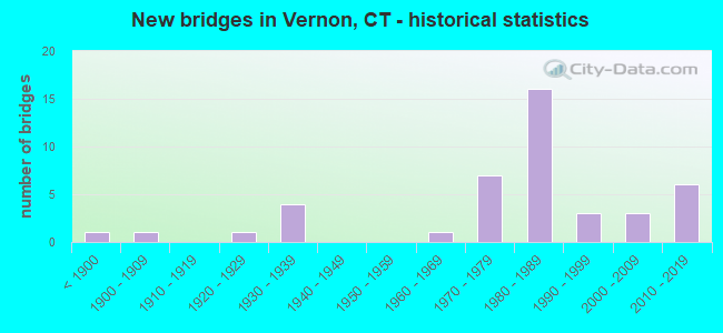
- New bridges - historical statistics
- 1Before 1900
- 11900-1909
- 11920-1929
- 41930-1939
- 11960-1969
- 71970-1979
- 161980-1989
- 31990-1999
- 32000-2009
- 62010-2019

- Reconstructed bridges - Historical Statistics
- 11950-1959
- 01960-1969
- 11970-1979
- 21980-1989
- 01990-1999
- 12000-2009


- Bridge Condition - Deck
- 13.0%Very good
- 52.2%Good
- 26.1%Satisfactory
- 4.3%Fair
- 4.3%Poor

- Bridge Condition - Superstructure
- 14.8%Very good
- 55.6%Good
- 22.2%Satisfactory
- 3.7%Fair
- 3.7%Poor

- Bridge Condition - Substructure
- 12.5%Very good
- 45.8%Good
- 37.5%Satisfactory
- 4.2%Poor

- Bridge Condition - Channel
- 4.0%Very good
- 32.0%Good
- 60.0%Satisfactory
- 4.0%Fair

- Bridge Condition - Culverts
- 50.0%Good
- 50.0%Satisfactory
Find on map >> Show street view
Structure Number: 524, Location: 0.25 MI W OF ROUTE 9 (Lat: 41.569239, Lng: -72.648186), Route carried "on" structure: State highway 66, Year Built: 1938, Year Reconstructed: 1994, Status: Open, Structure Length: 104.49m (342.81ft), Average Daily Traffic: 34,400 (year 2016), Truck Traffic: 6%, Average Future Daily Traffic: 51,115 (year 2036), Design Load: H 20, Features Intersected: P&W RR RT9 CONN RIVER
Minimum Vertical Clearance: 4.67m (15.32ft), Kilometerpoint: 11.475, Lanes on structure: 4, Lanes under structure: 17, Base Highway Network: Yes, Owner: State Highway Agency, Approaching Roadway Width: 13.7m (44.9ft), Skew: 9 degrees, Navigation Control: Yes ( Vertical Clearance: 28.0m (91.9ft), Horizontal Clearance: 146.3m (480.0ft)), Material/Design: Steel, Design/Construction: Arch - Thru, Number Of Spans In Main Unit: 2, Number Of Approach Spans: 28, Length of Maximum Span: 182.9m (600.1ft), Curb or Sidewalk Widths: Left: 1.4m (4.6ft), Right: 1.4m (4.6ft), Curb-To-Curb Width: 13.6m (44.6ft), Out-to-Out Width: 17.7m (58.1ft)
Condition: Deck: Poor, Superstructure: Poor, Substructure: Poor, Channel: Satisfactory, Operating Rating: 47.4 metric tons, Method Used To Determine Operating Rating: Load Factor (LF), Inventory Rating: 28.4 metric tons, Method Used To Determine Inventory Rating: Load Factor (LF), Structural Evaluation: Meets minimum limits, Deck Geometry: High priority of replacement, Underclear: High priority of corrective action, Waterway Adequacy: Superior to present desirable criteria, Approach Roadway Alignment: Somewhat better than minimum adequacy, Designated Inspection Frequency: Every 24 months, Critical Feature Inspection Frequency: Every 24 months, Underwater Inspection Frequency: Every 24 months, Inspection Date: January 2019, Critical Feature Inspection Date: January 2019, Underwater Inspection Date: January 2019, Total Project Cost: $37,000,000, Deck Structure Type: Concrete Cast-file-Place, Wearing Surface/Protective System: Wearing Surface: Bituminous, Membrane: Preformed Fabric
Find on map >> Show street view
Structure Number: 583, Location: 3.7 MI NORTH OF ROUTE 34 (Lat: 41.368486, Lng: -73.087300), Route carried "on" structure: State highway 8, Year Built: 1961, Year Reconstructed: 1991, Status: Open, Structure Length: 4.30m (14.11ft), Average Daily Traffic: 2,700 (year 2018), Truck Traffic: 5%, Average Future Daily Traffic: 4,012 (year 2038), Design Load: HS 20, Features Intersected: NB ACC LOWER DERBY AVE
Minimum Vertical Clearance: 30+ m (98+ ft), Kilometerpoint: 26.506, Lanes on structure: 2, Lanes under structure: 2, Base Highway Network: Yes, Owner: State Highway Agency, Approaching Roadway Width: 11.9m (39.0ft), Skew: 14 degrees, Material/Design: Steel, Design/Construction: Stringer/Multi-beam, Number Of Spans In Main Unit: 3, Length of Maximum Span: 16.5m (54.1ft), Curb-To-Curb Width: 12.4m (40.7ft), Out-to-Out Width: 13.6m (44.6ft)
Condition: Deck: Good, Superstructure: Satisfactory, Substructure: Good, Operating Rating: 59.6 metric tons, Method Used To Determine Operating Rating: Load and Resistance Factor Rating (LRFR) rating reported by rating factor(RF) method using HL-93 loadings, Inventory Rating: 46.0 metric tons, Method Used To Determine Inventory Rating: Load and Resistance Factor Rating (LRFR) rating reported by rating factor(RF) method using HL-93 loadings, Structural Evaluation: Equal to present minimum criteria, Deck Geometry: Better than present minimum criteria, Underclear: Meets minimum limits, Approach Roadway Alignment: Equal to present desirable criteria, Designated Inspection Frequency: Every 24 months, Inspection Date: July 2021, Deck Structure Type: Concrete Cast-file-Place, Wearing Surface/Protective System: Wearing Surface: Bituminous, Membrane: Preformed Fabric, Deck Protection: Epoxy Coated Reinforcing
Find on map >> Show street view
Structure Number: 1868, Location: .5 MILE EAST OF ROUTE 31 (Lat: 41.867947, Lng: -72.433425), Route carried "on" structure: State highway 74, Year Built: 1938, Status: Open, Structure Length: 0.88m (2.89ft), Average Daily Traffic: 3,400 (year 2017), Truck Traffic: 3%, Average Future Daily Traffic: 5,052 (year 2037), Design Load: H 20, Features Intersected: HOCKANUM RIVER
Minimum Vertical Clearance: 30+ m (98+ ft), Kilometerpoint: 12.070, Lanes on structure: 2, Owner: State Highway Agency, Approaching Roadway Width: 8.8m (28.9ft), Material/Design: Concrete, Design/Construction: Slab, Number Of Spans In Main Unit: 1, Length of Maximum Span: 7.9m (25.9ft), Curb or Sidewalk Widths: Left: 0.0m, Right: 2.0m (6.6ft), Curb-To-Curb Width: 8.7m (28.5ft), Out-to-Out Width: 11.9m (39.0ft)
Condition: Deck: Good, Superstructure: Good, Substructure: Satisfactory, Channel: Good, Operating Rating: 80.4 metric tons, Method Used To Determine Operating Rating: Load Factor (LF), Inventory Rating: 48.2 metric tons, Method Used To Determine Inventory Rating: Load Factor (LF), Structural Evaluation: Equal to present minimum criteria, Deck Geometry: Meets minimum limits, Waterway Adequacy: Equal to present minimum criteria, Approach Roadway Alignment: Equal to present desirable criteria, Designated Inspection Frequency: Every 24 months, Inspection Date: July 2021, Deck Structure Type: Concrete Cast-file-Place, Wearing Surface/Protective System: Wearing Surface: Bituminous, Membrane: Preformed Fabric
Find on map >> Show street view
Structure Number: 3238, Location: 50' SOUTH OF ROUTE 74 (Lat: 41.866667, Lng: -72.441667), Route carried "on" structure: State highway 31, Year Built: 1995, Status: Open, Structure Length: 1.25m (4.10ft), Average Daily Traffic: 8,100 (year 2017), Truck Traffic: 5%, Average Future Daily Traffic: 12,036 (year 2037), Design Load: HS 20, Features Intersected: HOCKANUM RIVER
Minimum Vertical Clearance: 30+ m (98+ ft), Kilometerpoint: 0.048, Lanes on structure: 2, Owner: State Highway Agency, Approaching Roadway Width: 11.0m (36.1ft), Material/Design: Prestressed concrete, Design/Construction: Slab, Number Of Spans In Main Unit: 1, Length of Maximum Span: 11.9m (39.0ft), Curb or Sidewalk Widths: Left: 1.7m (5.6ft), Right: 1.7m (5.6ft), Curb-To-Curb Width: 11.1m (36.4ft), Out-to-Out Width: 15.2m (49.9ft)
Condition: Deck: Good, Superstructure: Good, Substructure: Good, Channel: Good, Operating Rating: 46.7 metric tons, Method Used To Determine Operating Rating: Load and Resistance Factor Rating (LRFR) rating reported by rating factor(RF) method using HL-93 loadings, Inventory Rating: 35.0 metric tons, Method Used To Determine Inventory Rating: Load and Resistance Factor Rating (LRFR) rating reported by rating factor(RF) method using HL-93 loadings, Structural Evaluation: Better than present minimum criteria, Deck Geometry: Meets minimum limits, Waterway Adequacy: Equal to present desirable criteria, Approach Roadway Alignment: Better than present minimum criteria, Designated Inspection Frequency: Every 24 months, Inspection Date: March 2021, Deck Structure Type: Other, Wearing Surface/Protective System: Wearing Surface: Bituminous, Membrane: Built-up, Deck Protection: Epoxy Coated Reinforcing
Find on map >> Show street view
Structure Number: 3933, Location: 25 FT S OF BAMFORTH ROAD (Lat: 41.829675, Lng: -72.448111), Route carried "on" structure: City street , Year Built: 2007, Status: Open, Structure Length: 0.76m (2.49ft), Average Daily Traffic: 1,500 (year 2020), Truck Traffic: 4%, Average Future Daily Traffic: 2,229 (year 2040), Design Load: HS 20, Features Intersected: TANKERHOOSEN RIVER, Facility Carried by Structure: BOLTON ROAD
Minimum Vertical Clearance: 30+ m (98+ ft), Kilometerpoint: 3.428, Lanes on structure: 2, Owner: Town or Township Highway Agency, Approaching Roadway Width: 8.5m (27.9ft), Material/Design: Concrete, Design/Construction: Frame, Number Of Spans In Main Unit: 1, Length of Maximum Span: 7.6m (24.9ft), Curb or Sidewalk Widths: Left: 0.8m (2.6ft), Right: 0.8m (2.6ft), Curb-To-Curb Width: 8.5m (27.9ft), Out-to-Out Width: 10.0m (32.8ft)
Condition: Superstructure: Good, Channel: Satisfactory, Operating Rating: 64.6 metric tons, Method Used To Determine Operating Rating: Load Factor (LF), Inventory Rating: 38.7 metric tons, Method Used To Determine Inventory Rating: Load Factor (LF), Structural Evaluation: Better than present minimum criteria, Deck Geometry: Somewhat better than minimum adequacy, Waterway Adequacy: Equal to present desirable criteria, Approach Roadway Alignment: Equal to present desirable criteria, Designated Inspection Frequency: Every 24 months, Inspection Date: October 2021, Wearing Surface/Protective System: Wearing Surface: Bituminous
Find on map >> Show street view
Structure Number: 3934, Location: 200' SO OF WEST MAIN ST (Lat: 41.864672, Lng: -72.450992), Route carried "on" structure: City street , Year Built: 1925, Year Reconstructed: 2008, Status: Open, Structure Length: 0.70m (2.30ft), Average Daily Traffic: 3,145 (year 2021), Truck Traffic: 2%, Average Future Daily Traffic: 4,673 (year 2041), Design Load: HS 20, Features Intersected: HOCKANUM RIVER, Facility Carried by Structure: VERNON AVENUE
Minimum Vertical Clearance: 30+ m (98+ ft), Kilometerpoint: 2.317, Lanes on structure: 2, Owner: Town or Township Highway Agency, Approaching Roadway Width: 9.8m (32.2ft), Material/Design: Prestressed concrete, Design/Construction: Slab, Number Of Spans In Main Unit: 1, Length of Maximum Span: 6.1m (20.0ft), Curb or Sidewalk Widths: Left: 1.2m (3.9ft), Right: 1.2m (3.9ft), Curb-To-Curb Width: 9.7m (31.8ft), Out-to-Out Width: 13.1m (43.0ft)
Condition: Deck: Good, Superstructure: Good, Substructure: Satisfactory, Channel: Satisfactory, Operating Rating: 63.9 metric tons, Method Used To Determine Operating Rating: Load Factor (LF), Inventory Rating: 38.3 metric tons, Method Used To Determine Inventory Rating: Load Factor (LF), Structural Evaluation: Equal to present minimum criteria, Deck Geometry: Meets minimum limits, Waterway Adequacy: Equal to present desirable criteria, Approach Roadway Alignment: Equal to present desirable criteria, Designated Inspection Frequency: Every 24 months, Inspection Date: October 2021, Deck Structure Type: Concrete Cast-file-Place, Wearing Surface/Protective System: Wearing Surface: Bituminous, Membrane: Preformed Fabric
Find on map >> Show street view
Structure Number: 3936, Location: 1000 FT WEST OF ROUTE 83 (Lat: 41.850378, Lng: -72.488322), Route carried "on" structure: City street , Year Built: 1932, Status: Open, Structure Length: 0.70m (2.30ft), Average Daily Traffic: 9,107 (year 2021), Truck Traffic: 2%, Average Future Daily Traffic: 13,532 (year 2041), Design Load: H 20, Features Intersected: HOCKANUM RIVER, Facility Carried by Structure: DART HILL ROAD
Minimum Vertical Clearance: 30+ m (98+ ft), Kilometerpoint: 0.370, Lanes on structure: 2, Owner: Town or Township Highway Agency, Approaching Roadway Width: 8.2m (26.9ft), Skew: 2 degrees, Material/Design: Concrete, Design/Construction: Slab, Number Of Spans In Main Unit: 1, Length of Maximum Span: 6.1m (20.0ft), Curb or Sidewalk Widths: Left: 0.5m (1.6ft), Right: 0.5m (1.6ft), Curb-To-Curb Width: 7.2m (23.6ft), Out-to-Out Width: 8.2m (26.9ft)
Condition: Deck: Satisfactory, Superstructure: Satisfactory, Substructure: Satisfactory, Channel: Satisfactory, Operating Rating: 52.8 metric tons, Method Used To Determine Operating Rating: Load and Resistance Factor Rating (LRFR) rating reported by rating factor(RF) method using HL-93 loadings, Inventory Rating: 40.8 metric tons, Method Used To Determine Inventory Rating: Load and Resistance Factor Rating (LRFR) rating reported by rating factor(RF) method using HL-93 loadings, Structural Evaluation: Equal to present minimum criteria, Deck Geometry: High priority of replacement, Waterway Adequacy: Equal to present minimum criteria, Approach Roadway Alignment: Better than present minimum criteria, Designated Inspection Frequency: Every 24 months, Inspection Date: October 2021, Deck Structure Type: Concrete Cast-file-Place, Wearing Surface/Protective System: Wearing Surface: Bituminous
Find on map >> Show street view
Structure Number: 427, Location: 0.5 MILE WEST OF EXIT 66 (Lat: 41.829178, Lng: -72.474900), Route carried "on" structure: Interstate 84, Year Built: 2009, Status: Open, Structure Length: 0.70m (2.30ft), Average Daily Traffic: 49,200 (year 2018), Truck Traffic: 12%, Average Future Daily Traffic: 73,106 (year 2038), Design Load: HS 20, Features Intersected: RAILS TO TRAILS PATHWAY
Minimum Vertical Clearance: 30+ m (98+ ft), Kilometerpoint: 119.590, Lanes on structure: 4, Base Highway Network: Yes, Owner: State Highway Agency, Approaching Roadway Width: 23.2m (76.1ft), Skew: 1 degrees, Material/Design: Aluminum, Iron, Design/Construction: Arch - Deck, Number Of Spans In Main Unit: 1, Length of Maximum Span: 7.0m (23.0ft), Curb-To-Curb Width: 23.2m (76.1ft), Out-to-Out Width: 34.0m (111.5ft)
Condition: Superstructure: Good, Operating Rating: 97.2 metric tons, Method Used To Determine Operating Rating: Load and Resistance Factor Rating (LRFR) rating reported by rating factor(RF) method using HL-93 loadings, Inventory Rating: 76.1 metric tons, Method Used To Determine Inventory Rating: Load and Resistance Factor Rating (LRFR) rating reported by rating factor(RF) method using HL-93 loadings, Structural Evaluation: Better than present minimum criteria, Deck Geometry: Superior to present desirable criteria, Approach Roadway Alignment: Equal to present desirable criteria, Designated Inspection Frequency: Every 24 months, Inspection Date: December 2021, Wearing Surface/Protective System: Wearing Surface: Bituminous
Find on map >> Show street view
Structure Number: 4277, Location: INTERSTATE-84 EXIT 67 (Lat: 41.854483, Lng: -72.429200), Route carried "on" structure: Interstate 84, Year Built: 1978, Status: Open, Structure Length: 4.82m (15.81ft), Average Daily Traffic: 36,450 (year 2018), Truck Traffic: 14%, Average Future Daily Traffic: 54,161 (year 2038), Design Load: HS 20, Features Intersected: ROUTE 31
Minimum Vertical Clearance: 30+ m (98+ ft), Kilometerpoint: 124.338, Lanes on structure: 3, Lanes under structure: 4, Base Highway Network: Yes, Owner: State Highway Agency, Approaching Roadway Width: 17.7m (58.1ft), Skew: 10 degrees, Material/Design: Steel, Design/Construction: Stringer/Multi-beam, Number Of Spans In Main Unit: 1, Length of Maximum Span: 47.2m (154.9ft), Curb-To-Curb Width: 17.7m (58.1ft), Out-to-Out Width: 18.8m (61.7ft)
Condition: Deck: Good, Superstructure: Good, Substructure: Satisfactory, Operating Rating: 96.3 metric tons, Method Used To Determine Operating Rating: Load Factor (LF), Inventory Rating: 57.8 metric tons, Method Used To Determine Inventory Rating: Load Factor (LF), Structural Evaluation: Equal to present minimum criteria, Deck Geometry: Better than present minimum criteria, Underclear: Better than present minimum criteria, Approach Roadway Alignment: Equal to present desirable criteria, Designated Inspection Frequency: Every 24 months, Inspection Date: October 2020, Deck Structure Type: Concrete Cast-file-Place, Wearing Surface/Protective System: Wearing Surface: Bituminous, Membrane: Preformed Fabric
Find on map >> Show street view
Structure Number: 4572, Location: 75FT FR JCT WEST MAIN ST (Lat: 41.864822, Lng: -72.458139), Route carried "on" structure: City street , Year Built: 2010, Status: Open, Structure Length: 1.95m (6.40ft), Average Daily Traffic: 1,460 (year 2021), Truck Traffic: 2%, Average Future Daily Traffic: 2,169 (year 2041), Design Load: HL 93, Features Intersected: HOCKANUM RIVER, Facility Carried by Structure: SPRING STREET
Minimum Vertical Clearance: 30+ m (98+ ft), Kilometerpoint: 0.290, Lanes on structure: 2, Owner: Town or Township Highway Agency, Approaching Roadway Width: 9.4m (30.8ft), Skew: 2 degrees, Material/Design: Concrete, Design/Construction: Frame, Number Of Spans In Main Unit: 2, Length of Maximum Span: 9.1m (29.9ft), Curb or Sidewalk Widths: Left: 0.5m (1.6ft), Right: 2.2m (7.2ft), Curb-To-Curb Width: 9.4m (30.8ft), Out-to-Out Width: 12.2m (40.0ft)
Condition: Superstructure: Good, Channel: Satisfactory, Operating Rating: 33.4 metric tons, Method Used To Determine Operating Rating: Load and Resistance Factor Rating (LRFR) rating reported by rating factor(RF) method using HL-93 loadings, Inventory Rating: 25.6 metric tons, Method Used To Determine Inventory Rating: Load and Resistance Factor Rating (LRFR) rating reported by rating factor(RF) method using HL-93 loadings, Structural Evaluation: Equal to present minimum criteria, Deck Geometry: Somewhat better than minimum adequacy, Waterway Adequacy: Equal to present desirable criteria, Approach Roadway Alignment: Equal to present desirable criteria, Designated Inspection Frequency: Every 24 months, Inspection Date: September 2021, Wearing Surface/Protective System: Wearing Surface: Bituminous, Membrane: Built-up
Find on map >> Show street view
Structure Number: 4573, Location: 500 FEET EAST OF SR 527 (Lat: 41.865767, Lng: -72.463292), Route carried "on" structure: City street , Year Built: 2014, Status: Open, Structure Length: 1.22m (4.00ft), Average Daily Traffic: 683 (year 2021), Truck Traffic: 2%, Average Future Daily Traffic: 1,015 (year 2041), Design Load: HL 93, Features Intersected: HOCKANUM RIVER, Facility Carried by Structure: WEST MAIN STREET
Minimum Vertical Clearance: 30+ m (98+ ft), Kilometerpoint: 0.129, Lanes on structure: 2, Owner: Town or Township Highway Agency, Approaching Roadway Width: 9.9m (32.5ft), Skew: 2 degrees, Material/Design: Prestressed concrete, Design/Construction: Slab, Number Of Spans In Main Unit: 1, Length of Maximum Span: 11.4m (37.4ft), Curb or Sidewalk Widths: Left: 2.4m (7.9ft), Right: 0.5m (1.6ft), Curb-To-Curb Width: 9.8m (32.2ft), Out-to-Out Width: 12.6m (41.3ft)
Condition: Deck: Good, Superstructure: Very good, Substructure: Good, Channel: Good, Operating Rating: 45.7 metric tons, Method Used To Determine Operating Rating: Load and Resistance Factor Rating (LRFR) rating reported by rating factor(RF) method using HL-93 loadings, Inventory Rating: 35.3 metric tons, Method Used To Determine Inventory Rating: Load and Resistance Factor Rating (LRFR) rating reported by rating factor(RF) method using HL-93 loadings, Structural Evaluation: Better than present minimum criteria, Deck Geometry: Equal to present minimum criteria, Waterway Adequacy: Better than present minimum criteria, Approach Roadway Alignment: Better than present minimum criteria, Designated Inspection Frequency: Every 24 months, Inspection Date: October 2021, Deck Structure Type: Other, Wearing Surface/Protective System: Wearing Surface: Bituminous, Membrane: Built-up, Deck Protection: Epoxy Coated Reinforcing
Find on map >> Show street view
Structure Number: 4574, Location: 400 FT FROM JCT ROUTE 74 (Lat: 41.867831, Lng: -72.465833), Route carried "on" structure: City street , Year Built: 1900, Year Reconstructed: 1955, Status: Open, Structure Length: 0.70m (2.30ft), Average Daily Traffic: 1,623 (year 2021), Truck Traffic: 2%, Average Future Daily Traffic: 2,412 (year 2041), Features Intersected: HOCKANUM RIVER, Facility Carried by Structure: WINDSOR AVENUE
Minimum Vertical Clearance: 30+ m (98+ ft), Kilometerpoint: 0.064, Lanes on structure: 1, Owner: Town or Township Highway Agency, Approaching Roadway Width: 8.8m (28.9ft), Material/Design: Concrete, Design/Construction: Slab, Number Of Spans In Main Unit: 1, Length of Maximum Span: 6.1m (20.0ft), Curb or Sidewalk Widths: Left: 2.0m (6.6ft), Right: 2.0m (6.6ft), Curb-To-Curb Width: 8.9m (29.2ft), Out-to-Out Width: 12.9m (42.3ft)
Condition: Deck: Fair, Superstructure: Fair, Substructure: Satisfactory, Channel: Satisfactory, Operating Rating: 42.6 metric tons, Method Used To Determine Operating Rating: Field evaluation and documented engineering judgment, Inventory Rating: 32.7 metric tons, Method Used To Determine Inventory Rating: Field evaluation and documented engineering judgment, Structural Evaluation: Somewhat better than minimum adequacy, Deck Geometry: Somewhat better than minimum adequacy, Waterway Adequacy: Better than present minimum criteria, Approach Roadway Alignment: Better than present minimum criteria, Designated Inspection Frequency: Every 24 months, Inspection Date: October 2021, Deck Structure Type: Concrete Cast-file-Place, Wearing Surface/Protective System: Wearing Surface: Bituminous
Find on map >> Show street view
Structure Number: 4575, Location: 0.4 MILE FROM ROUTE 83 (Lat: 41.822214, Lng: -72.498022), Route carried "on" structure: City street , Year Built: 1885, Year Reconstructed: 2021, Status: Open, Structure Length: 2.59m (8.50ft), Average Daily Traffic: 21 (year 2021), Truck Traffic: 1%, Average Future Daily Traffic: 31 (year 2041), Design Load: HS 25 or greater, Features Intersected: TANKERHOOSEN RIVER, Facility Carried by Structure: MAIN STREET
Minimum Vertical Clearance: 30+ m (98+ ft), Kilometerpoint: 0.080, Lanes on structure: 1, Owner: Town or Township Highway Agency, Approaching Roadway Width: 4.3m (14.1ft), Skew: 1 degrees, Material/Design: Steel, Design/Construction: Stringer/Multi-beam, Number Of Spans In Main Unit: 1, Length of Maximum Span: 22.7m (74.5ft), Curb-To-Curb Width: 4.3m (14.1ft), Out-to-Out Width: 5.3m (17.4ft)
Condition: Deck: Very good, Superstructure: Very good, Substructure: Very good, Channel: Satisfactory, Operating Rating: 69.3 metric tons, Method Used To Determine Operating Rating: Load and Resistance Factor Rating (LRFR) rating reported by rating factor(RF) method using HL-93 loadings, Inventory Rating: 53.1 metric tons, Method Used To Determine Inventory Rating: Load and Resistance Factor Rating (LRFR) rating reported by rating factor(RF) method using HL-93 loadings, Structural Evaluation: Equal to present desirable criteria, Deck Geometry: Equal to present minimum criteria, Waterway Adequacy: Equal to present desirable criteria, Approach Roadway Alignment: Equal to present desirable criteria, Designated Inspection Frequency: Every 24 months, Underwater Inspection Frequency: Every 24 months, Inspection Date: November 2021, Underwater Inspection Date: November 2021, Total Project Cost: $2,000,000 ( Estimate for 2014), Deck Structure Type: Concrete Cast-file-Place, Wearing Surface/Protective System: Wearing Surface: Bituminous, Membrane: Preformed Fabric, Deck Protection: Galvanized Reinforcing
Find on map >> Show street view
Structure Number: 4576, Location: 900 FT WEST OF ROUTE 83 (Lat: 41.832497, Lng: -72.496842), Route carried "on" structure: City street , Year Built: 2018, Status: Open, Structure Length: 1.46m (4.79ft), Average Daily Traffic: 1,082 (year 2021), Truck Traffic: 2%, Average Future Daily Traffic: 1,608 (year 2041), Design Load: HL 93, Features Intersected: HOCKANUM RIVER, Facility Carried by Structure: PLEASANTVIEW DRIVE
Minimum Vertical Clearance: 30+ m (98+ ft), Kilometerpoint: 0.274, Lanes on structure: 2, Owner: Town or Township Highway Agency, Approaching Roadway Width: 8.5m (27.9ft), Material/Design: Prestressed concrete, Design/Construction: Slab, Number Of Spans In Main Unit: 1, Length of Maximum Span: 13.7m (44.9ft), Curb or Sidewalk Widths: Left: 1.5m (4.9ft), Right: 0.0m, Curb-To-Curb Width: 8.6m (28.2ft), Out-to-Out Width: 11.2m (36.7ft)
Condition: Deck: Very good, Superstructure: Very good, Substructure: Good, Channel: Good, Operating Rating: 82.3 metric tons, Method Used To Determine Operating Rating: Load and Resistance Factor Rating (LRFR) rating reported by rating factor(RF) method using HL-93 loadings, Inventory Rating: 63.2 metric tons, Method Used To Determine Inventory Rating: Load and Resistance Factor Rating (LRFR) rating reported by rating factor(RF) method using HL-93 loadings, Structural Evaluation: Better than present minimum criteria, Deck Geometry: Somewhat better than minimum adequacy, Waterway Adequacy: Equal to present desirable criteria, Approach Roadway Alignment: Better than present minimum criteria, Designated Inspection Frequency: Every 24 months, Inspection Date: October 2021, Total Project Cost: $2,284,000 ( Estimate for 2016), Deck Structure Type: Other, Wearing Surface/Protective System: Wearing Surface: Bituminous, Membrane: Built-up, Deck Protection: Epoxy Coated Reinforcing
Find on map >> Show street view
Structure Number: 4577, Location: AT JCT WEST MAIN STREET (Lat: 41.865233, Lng: -72.461803), Route carried "on" structure: City street , Year Built: 2010, Status: Open, Structure Length: 1.59m (5.22ft), Average Daily Traffic: 1,261 (year 2021), Truck Traffic: 2%, Average Future Daily Traffic: 1,874 (year 2041), Design Load: HS 20, Features Intersected: HOCKANUM RIVER, Facility Carried by Structure: RIVER STREET
Minimum Vertical Clearance: 30+ m (98+ ft), Kilometerpoint: 0.241, Lanes on structure: 2, Owner: Town or Township Highway Agency, Approaching Roadway Width: 9.1m (29.9ft), Material/Design: Prestressed concrete, Design/Construction: Slab, Number Of Spans In Main Unit: 1, Length of Maximum Span: 14.9m (48.9ft), Curb or Sidewalk Widths: Left: 2.2m (7.2ft), Right: 1.2m (3.9ft), Curb-To-Curb Width: 9.4m (30.8ft), Out-to-Out Width: 12.8m (42.0ft)
Condition: Deck: Good, Superstructure: Good, Substructure: Very good, Channel: Good, Operating Rating: 65.9 metric tons, Method Used To Determine Operating Rating: Load Factor (LF), Inventory Rating: 31.3 metric tons, Method Used To Determine Inventory Rating: Load Factor (LF), Structural Evaluation: Better than present minimum criteria, Deck Geometry: Somewhat better than minimum adequacy, Waterway Adequacy: Equal to present desirable criteria, Approach Roadway Alignment: Equal to present desirable criteria, Designated Inspection Frequency: Every 24 months, Inspection Date: September 2021, Deck Structure Type: Other, Wearing Surface/Protective System: Wearing Surface: Bituminous, Membrane: Built-up
Find on map >> Show street view
Structure Number: 5228, Location: .25 MILE WEST OF EXIT 64 (Lat: 41.821811, Lng: -72.503519), Route carried "on" structure: Interstate 84, Year Built: 1981, Status: Open, Structure Length: 3.70m (12.14ft), Average Daily Traffic: 52,950 (year 2018), Truck Traffic: 14%, Average Future Daily Traffic: 78,678 (year 2038), Design Load: HS 20, Features Intersected: HOCKANUM RIVER
Minimum Vertical Clearance: 30+ m (98+ ft), Kilometerpoint: 117.064, Lanes on structure: 6, Base Highway Network: Yes, Owner: State Highway Agency, Approaching Roadway Width: 44.2m (145.0ft), Material/Design: Prestressed concrete, Design/Construction: Stringer/Multi-beam, Number Of Spans In Main Unit: 1, Length of Maximum Span: 35.4m (116.1ft), Curb-To-Curb Width: 44.1m (144.7ft), Out-to-Out Width: 45.6m (149.6ft)
Condition: Deck: Good, Superstructure: Good, Substructure: Satisfactory, Channel: Satisfactory, Operating Rating: 60.6 metric tons, Method Used To Determine Operating Rating: Load and Resistance Factor Rating (LRFR) rating reported by rating factor(RF) method using HL-93 loadings, Inventory Rating: 46.7 metric tons, Method Used To Determine Inventory Rating: Load and Resistance Factor Rating (LRFR) rating reported by rating factor(RF) method using HL-93 loadings, Structural Evaluation: Equal to present minimum criteria, Deck Geometry: Superior to present desirable criteria, Waterway Adequacy: Equal to present desirable criteria, Approach Roadway Alignment: Equal to present desirable criteria, Designated Inspection Frequency: Every 24 months, Inspection Date: August 2020, Deck Structure Type: Concrete Cast-file-Place, Wearing Surface/Protective System: Wearing Surface: Bituminous, Membrane: Built-up
Find on map >> Show street view
Structure Number: 5229, Location: .1 MILE E OF S.WINDSOR TL (Lat: 41.822164, Lng: -72.503839), Route carried "on" structure: Interstate 84, Year Built: 1982, Status: Open, Structure Length: 3.72m (12.20ft), Average Daily Traffic: 52,950 (year 2018), Truck Traffic: 14%, Average Future Daily Traffic: 78,678 (year 2038), Design Load: HS 20, Features Intersected: HOCKANUM RIVER
Minimum Vertical Clearance: 30+ m (98+ ft), Kilometerpoint: 117.064, Lanes on structure: 6, Base Highway Network: Yes, Owner: State Highway Agency, Approaching Roadway Width: 46.0m (150.9ft), Skew: 20 degrees, Material/Design: Prestressed concrete, Design/Construction: Stringer/Multi-beam, Number Of Spans In Main Unit: 1, Length of Maximum Span: 35.4m (116.1ft), Curb-To-Curb Width: 46.2m (151.6ft), Out-to-Out Width: 50.2m (164.7ft)
Condition: Deck: Satisfactory, Superstructure: Satisfactory, Substructure: Satisfactory, Channel: Satisfactory, Operating Rating: 62.5 metric tons, Method Used To Determine Operating Rating: Load and Resistance Factor Rating (LRFR) rating reported by rating factor(RF) method using HL-93 loadings, Inventory Rating: 48.3 metric tons, Method Used To Determine Inventory Rating: Load and Resistance Factor Rating (LRFR) rating reported by rating factor(RF) method using HL-93 loadings, Structural Evaluation: Equal to present minimum criteria, Deck Geometry: Superior to present desirable criteria, Waterway Adequacy: Equal to present desirable criteria, Approach Roadway Alignment: Equal to present desirable criteria, Designated Inspection Frequency: Every 24 months, Inspection Date: August 2020, Deck Structure Type: Concrete Cast-file-Place, Wearing Surface/Protective System: Wearing Surface: Bituminous, Membrane: Built-up
Find on map >> Show street view
Structure Number: 5232, Location: .63 MI E OF MANCHESTER TL (Lat: 41.824681, Lng: -72.493897), Route carried "on" structure: Ramp Interstate 84, Year Built: 1982, Status: Open, Structure Length: 12.53m (41.11ft), Average Daily Traffic: 12,600 (year 2018), Truck Traffic: 14%, Average Future Daily Traffic: 18,722 (year 2038), Design Load: HS 20, Features Intersected: INTERSTATE-84
Minimum Vertical Clearance: 6.96m (22.83ft), Kilometerpoint: 10.332, Lanes on structure: 3, Lanes under structure: 8, Owner: State Highway Agency, Approaching Roadway Width: 16.5m (54.1ft), Skew: 9 degrees, Material/Design: Steel continuous, Design/Construction: Box Beam or Girders - Single/Spread, Number Of Spans In Main Unit: 2, Length of Maximum Span: 64.0m (210.0ft), Curb-To-Curb Width: 16.5m (54.1ft), Out-to-Out Width: 17.6m (57.7ft)
Condition: Deck: Satisfactory, Superstructure: Satisfactory, Substructure: Satisfactory, Inventory Rating: 61.7 metric tons, Method Used To Determine Inventory Rating: Load Factor (LF), Structural Evaluation: Equal to present minimum criteria, Deck Geometry: Superior to present desirable criteria, Underclear: Better than present minimum criteria, Approach Roadway Alignment: Equal to present minimum criteria, Designated Inspection Frequency: Every 24 months, Inspection Date: August 2021, Deck Structure Type: Concrete Cast-file-Place, Wearing Surface/Protective System: Wearing Surface: Bituminous, Membrane: Preformed Fabric
Find on map >> Show street view
Structure Number: 5233, Location: .56 MI EAST OF RT 30 & 83 (Lat: 41.825953, Lng: -72.488686), Route carried "on" structure: City street , Year Built: 1981, Status: Open, Structure Length: 9.98m (32.74ft), Average Daily Traffic: 5,200 (year 2020), Truck Traffic: 3%, Average Future Daily Traffic: 7,727 (year 2040), Design Load: HS 20, Features Intersected: INTERSTATE-84 & RAMP 016, Facility Carried by Structure: DOBSON ROAD
Minimum Vertical Clearance: 30+ m (98+ ft), Kilometerpoint: 12.086, Lanes on structure: 2, Lanes under structure: 9, Owner: State Highway Agency, Approaching Roadway Width: 15.9m (52.2ft), Material/Design: Steel continuous, Design/Construction: Box Beam or Girders - Single/Spread, Number Of Spans In Main Unit: 2, Length of Maximum Span: 51.8m (169.9ft), Curb or Sidewalk Widths: Left: 2.1m (6.9ft), Right: 2.1m (6.9ft), Curb-To-Curb Width: 15.9m (52.2ft), Out-to-Out Width: 20.9m (68.6ft)
Condition: Deck: Good, Superstructure: Satisfactory, Substructure: Good, Operating Rating: 48.9 metric tons, Method Used To Determine Operating Rating: Load and Resistance Factor Rating (LRFR) rating reported by rating factor(RF) method using HL-93 loadings, Inventory Rating: 37.9 metric tons, Method Used To Determine Inventory Rating: Load and Resistance Factor Rating (LRFR) rating reported by rating factor(RF) method using HL-93 loadings, Structural Evaluation: Equal to present minimum criteria, Deck Geometry: Superior to present desirable criteria, Underclear: Somewhat better than minimum adequacy, Approach Roadway Alignment: Equal to present desirable criteria, Designated Inspection Frequency: Every 24 months, Inspection Date: August 2021, Deck Structure Type: Concrete Cast-file-Place, Wearing Surface/Protective System: Wearing Surface: Bituminous, Membrane: Preformed Fabric
Find on map >> Show street view
Structure Number: 5236, Location: I-84 WB EXIT NO. 64 (Lat: 41.823664, Lng: -72.501517), Route carried "on" structure: Ramp Interstate 84, Year Built: 1982, Status: Open, Structure Length: 3.89m (12.76ft), Average Daily Traffic: 2,880 (year 2020), Truck Traffic: 9%, Average Future Daily Traffic: 4,279 (year 2040), Design Load: HS 20, Features Intersected: I-84 WB RAMP FROM 30/83
Minimum Vertical Clearance: 30+ m (98+ ft), Kilometerpoint: 1.287, Lanes on structure: 1, Lanes under structure: 1, Owner: State Highway Agency, Approaching Roadway Width: 7.3m (24.0ft), Skew: 9 degrees, Material/Design: Steel, Design/Construction: Stringer/Multi-beam, Number Of Spans In Main Unit: 1, Length of Maximum Span: 37.2m (122.0ft), Curb-To-Curb Width: 7.3m (24.0ft), Out-to-Out Width: 8.5m (27.9ft)
Condition: Deck: Good, Superstructure: Good, Substructure: Good, Operating Rating: 72.9 metric tons, Method Used To Determine Operating Rating: Load and Resistance Factor Rating (LRFR) rating reported by rating factor(RF) method using HL-93 loadings, Inventory Rating: 56.4 metric tons, Method Used To Determine Inventory Rating: Load and Resistance Factor Rating (LRFR) rating reported by rating factor(RF) method using HL-93 loadings, Structural Evaluation: Better than present minimum criteria, Deck Geometry: Better than present minimum criteria, Underclear: Equal to present desirable criteria, Approach Roadway Alignment: Better than present minimum criteria, Designated Inspection Frequency: Every 24 months, Inspection Date: August 2020, Deck Structure Type: Concrete Cast-file-Place, Wearing Surface/Protective System: Wearing Surface: Bituminous, Membrane: Preformed Fabric
Find on map >> Show street view
Structure Number: 5239, Location: 0.3 MI E OF MANCHESTER TL (Lat: 41.819467, Lng: -72.501817), Route carried "on" structure: State highway 30, Year Built: 1932, Year Reconstructed: 1981, Status: Open, Structure Length: 0.98m (3.22ft), Average Daily Traffic: 19,300 (year 2017), Truck Traffic: 4%, Average Future Daily Traffic: 28,678 (year 2037), Features Intersected: TANKERHOOSEN RIVER
Minimum Vertical Clearance: 30+ m (98+ ft), Kilometerpoint: 12.086, Lanes on structure: 4, Base Highway Network: Yes, Owner: State Highway Agency, Approaching Roadway Width: 15.9m (52.2ft), Material/Design: Concrete continuous, Design/Construction: Culvert, Number Of Spans In Main Unit: 3, Length of Maximum Span: 3.0m (9.8ft), Curb or Sidewalk Widths: Left: 2.1m (6.9ft), Right: 2.1m (6.9ft), Curb-To-Curb Width: 15.9m (52.2ft), Out-to-Out Width: 20.9m (68.6ft)
Condition: Channel: Satisfactory, Culverts: Satisfactory, Operating Rating: 13.6 metric tons, Method Used To Determine Operating Rating: Load and Resistance Factor Rating (LRFR) rating reported by rating factor(RF) method using HL-93 loadings, Inventory Rating: 10.7 metric tons, Method Used To Determine Inventory Rating: Load and Resistance Factor Rating (LRFR) rating reported by rating factor(RF) method using HL-93 loadings, Structural Evaluation: High priority of corrective action, Deck Geometry: Meets minimum limits, Waterway Adequacy: Better than present minimum criteria, Approach Roadway Alignment: Equal to present desirable criteria, Designated Inspection Frequency: Every 24 months, Inspection Date: Febuary 2021, Deck Structure Type: Concrete Cast-file-Place, Wearing Surface/Protective System: Wearing Surface: Bituminous, Membrane: Preformed Fabric
Find on map >> Show street view
Structure Number: 524, Location: 0.3 MILES WEST OF RT.83 (Lat: 41.824867, Lng: -72.502528), Route carried "on" structure: City street , Year Built: 1981, Status: Open, Structure Length: 3.23m (10.60ft), Average Daily Traffic: 6,925 (year 2021), Truck Traffic: 4%, Average Future Daily Traffic: 10,290 (year 2041), Design Load: HS 20, Features Intersected: HOCKANUM RIVER, Facility Carried by Structure: KELLY ROAD
Minimum Vertical Clearance: 30+ m (98+ ft), Kilometerpoint: 1.706, Lanes on structure: 4, Owner: Town or Township Highway Agency, Approaching Roadway Width: 15.9m (52.2ft), Skew: 3 degrees, Material/Design: Prestressed concrete, Design/Construction: Stringer/Multi-beam, Number Of Spans In Main Unit: 1, Length of Maximum Span: 30.5m (100.1ft), Curb or Sidewalk Widths: Left: 2.7m (8.9ft), Right: 2.7m (8.9ft), Curb-To-Curb Width: 15.9m (52.2ft), Out-to-Out Width: 21.2m (69.6ft)
Condition: Deck: Satisfactory, Superstructure: Good, Substructure: Good, Channel: Satisfactory, Operating Rating: 77.8 metric tons, Method Used To Determine Operating Rating: Load Factor (LF), Inventory Rating: 46.6 metric tons, Method Used To Determine Inventory Rating: Load Factor (LF), Structural Evaluation: Better than present minimum criteria, Deck Geometry: Meets minimum limits, Waterway Adequacy: Equal to present desirable criteria, Approach Roadway Alignment: Equal to present desirable criteria, Designated Inspection Frequency: Every 24 months, Inspection Date: October 2021, Deck Structure Type: Concrete Cast-file-Place, Wearing Surface/Protective System: Wearing Surface: Bituminous, Membrane: Preformed Fabric, Deck Protection: Epoxy Coated Reinforcing
Find on map >> Show street view
Structure Number: 5374, Location: 0.2 MILES SO. OF RTE. 30 (Lat: 41.824217, Lng: -72.487572), Route carried "on" structure: City street , Year Built: 1986, Status: Open, Structure Length: 2.29m (7.51ft), Average Daily Traffic: 5,200 (year 2020), Truck Traffic: 4%, Average Future Daily Traffic: 7,727 (year 2040), Design Load: HS 20, Features Intersected: DOBSONVILLE POND, Facility Carried by Structure: DOBSON ROAD
Minimum Vertical Clearance: 30+ m (98+ ft), Kilometerpoint: 1.062, Lanes on structure: 2, Owner: Town or Township Highway Agency, Approaching Roadway Width: 9.8m (32.2ft), Material/Design: Steel, Design/Construction: Stringer/Multi-beam, Number Of Spans In Main Unit: 1, Length of Maximum Span: 21.9m (71.9ft), Curb or Sidewalk Widths: Left: 2.1m (6.9ft), Right: 2.1m (6.9ft), Curb-To-Curb Width: 9.8m (32.2ft), Out-to-Out Width: 13.9m (45.6ft)
Condition: Deck: Good, Superstructure: Good, Substructure: Good, Channel: Good, Operating Rating: 81.4 metric tons, Method Used To Determine Operating Rating: Load Factor (LF), Inventory Rating: 48.8 metric tons, Method Used To Determine Inventory Rating: Load Factor (LF), Structural Evaluation: Better than present minimum criteria, Deck Geometry: Meets minimum limits, Waterway Adequacy: Equal to present desirable criteria, Approach Roadway Alignment: Equal to present desirable criteria, Designated Inspection Frequency: Every 24 months, Inspection Date: September 2021, Deck Structure Type: Concrete Cast-file-Place, Wearing Surface/Protective System: Wearing Surface: Bituminous, Membrane: Preformed Fabric, Deck Protection: Epoxy Coated Reinforcing
Find on map >> Show street view
Structure Number: 5588, Location: .5 MI WEST OF ROUTE 83 (Lat: 41.865931, Lng: -72.486378), Route carried "on" structure: State highway 74, Year Built: 2016, Status: Open, Structure Length: 1.37m (4.49ft), Average Daily Traffic: 7,500 (year 2015), Truck Traffic: 3%, Average Future Daily Traffic: 11,144 (year 2035), Design Load: HL 93, Features Intersected: HOCKANUM RIVER
Minimum Vertical Clearance: 30+ m (98+ ft), Kilometerpoint: 7.371, Lanes on structure: 2, Owner: State Highway Agency, Approaching Roadway Width: 9.5m (31.2ft), Material/Design: Prestressed concrete, Design/Construction: Slab, Number Of Spans In Main Unit: 1, Length of Maximum Span: 12.8m (42.0ft), Curb or Sidewalk Widths: Left: 0.0m, Right: 1.5m (4.9ft), Curb-To-Curb Width: 9.8m (32.2ft), Out-to-Out Width: 12.2m (40.0ft)
Condition: Deck: Very good, Superstructure: Very good, Substructure: Very good, Channel: Very good, Operating Rating: 64.2 metric tons, Method Used To Determine Operating Rating: Load and Resistance Factor Rating (LRFR) rating reported by rating factor(RF) method using HL-93 loadings, Inventory Rating: 42.1 metric tons, Method Used To Determine Inventory Rating: Load and Resistance Factor Rating (LRFR) rating reported by rating factor(RF) method using HL-93 loadings, Structural Evaluation: Equal to present desirable criteria, Deck Geometry: Meets minimum limits, Waterway Adequacy: Equal to present desirable criteria, Approach Roadway Alignment: Equal to present minimum criteria, Designated Inspection Frequency: Every 24 months, Inspection Date: September 2020, Deck Structure Type: Concrete Cast-file-Place, Wearing Surface/Protective System: Wearing Surface: Bituminous, Membrane: Built-up, Deck Protection: Epoxy Coated Reinforcing
Find on map >> Show street view
Structure Number: 5711, Location: .5 MI S OF INTERSTATE-84 (Lat: 41.827131, Lng: -72.464083), Route carried "on" structure: State highway 533, Year Built: 1989, Status: Open, Structure Length: 0.85m (2.79ft), Average Daily Traffic: 3,000 (year 2020), Truck Traffic: 3%, Average Future Daily Traffic: 4,458 (year 2040), Features Intersected: TANKERHOOSEN RIVER
Minimum Vertical Clearance: 30+ m (98+ ft), Kilometerpoint: 5.359, Lanes on structure: 2, Owner: State Highway Agency, Approaching Roadway Width: 6.4m (21.0ft), Material/Design: Concrete, Design/Construction: Culvert, Number Of Spans In Main Unit: 2, Length of Maximum Span: 4.0m (13.1ft)
Condition: Channel: Fair, Culverts: Good, Operating Rating: 42.6 metric tons, Method Used To Determine Operating Rating: Field evaluation and documented engineering judgment, Inventory Rating: 32.7 metric tons, Method Used To Determine Inventory Rating: Field evaluation and documented engineering judgment, Structural Evaluation: Better than present minimum criteria, Waterway Adequacy: Better than present minimum criteria, Approach Roadway Alignment: Equal to present desirable criteria, Designated Inspection Frequency: Every 24 months, Inspection Date: January 2022
Find on map >> Show street view
Structure Number: 583, Location: 100 FT FR JCT ROUTE 74 (Lat: 41.867197, Lng: -72.442933), Route carried "on" structure: City street , Year Built: 1988, Status: Open, Structure Length: 1.04m (3.41ft), Average Daily Traffic: 733 (year 2021), Truck Traffic: 2%, Average Future Daily Traffic: 1,089 (year 2041), Design Load: HS 20, Features Intersected: HOCKANUM RIVER, Facility Carried by Structure: BROOKLYN STREET
Minimum Vertical Clearance: 30+ m (98+ ft), Kilometerpoint: 0.724, Lanes on structure: 2, Owner: Town or Township Highway Agency, Approaching Roadway Width: 8.5m (27.9ft), Skew: 2 degrees, Material/Design: Prestressed concrete, Design/Construction: Box Beam or Girders - Multiple, Number Of Spans In Main Unit: 1, Length of Maximum Span: 9.1m (29.9ft), Curb or Sidewalk Widths: Left: 1.9m (6.2ft), Right: 0.0m, Curb-To-Curb Width: 8.4m (27.6ft), Out-to-Out Width: 10.3m (33.8ft)
Condition: Deck: Good, Superstructure: Good, Substructure: Good, Channel: Good, Operating Rating: 69.6 metric tons, Method Used To Determine Operating Rating: Load Factor (LF), Inventory Rating: 41.7 metric tons, Method Used To Determine Inventory Rating: Load Factor (LF), Structural Evaluation: Better than present minimum criteria, Deck Geometry: Somewhat better than minimum adequacy, Waterway Adequacy: Equal to present desirable criteria, Approach Roadway Alignment: Equal to present desirable criteria, Designated Inspection Frequency: Every 48 months, Inspection Date: October 2021, Deck Structure Type: Other, Wearing Surface/Protective System: Wearing Surface: Bituminous, Membrane: Preformed Fabric
Find on map >> Show street view
Structure Number: 5961, Location: 0.1 MILE SOUTH OF RTE 74 (Lat: 41.866592, Lng: -72.464769), Route carried "on" structure: State highway 527, Year Built: 1990, Status: Open, Structure Length: 1.16m (3.81ft), Average Daily Traffic: 11,400 (year 2017), Truck Traffic: 3%, Average Future Daily Traffic: 16,939 (year 2037), Design Load: HS 20, Features Intersected: HOCKANUM RIVER
Minimum Vertical Clearance: 30+ m (98+ ft), Kilometerpoint: 3.090, Lanes on structure: 2, Owner: State Highway Agency, Approaching Roadway Width: 11.0m (36.1ft), Skew: 3 degrees, Material/Design: Concrete, Design/Construction: Tee Beam, Number Of Spans In Main Unit: 1, Length of Maximum Span: 10.1m (33.1ft), Curb or Sidewalk Widths: Left: 1.7m (5.6ft), Right: 1.7m (5.6ft), Curb-To-Curb Width: 11.0m (36.1ft), Out-to-Out Width: 15.1m (49.5ft)
Condition: Deck: Satisfactory, Superstructure: Satisfactory, Substructure: Good, Channel: Satisfactory, Operating Rating: 76.1 metric tons, Method Used To Determine Operating Rating: Load Factor (LF), Inventory Rating: 45.7 metric tons, Method Used To Determine Inventory Rating: Load Factor (LF), Structural Evaluation: Equal to present minimum criteria, Deck Geometry: Meets minimum limits, Waterway Adequacy: Equal to present desirable criteria, Approach Roadway Alignment: Equal to present desirable criteria, Designated Inspection Frequency: Every 24 months, Inspection Date: Febuary 2021, Deck Structure Type: Concrete Cast-file-Place, Wearing Surface/Protective System: Wearing Surface: Bituminous, Membrane: Preformed Fabric, Deck Protection: Epoxy Coated Reinforcing
Find on map >> Show street view
Structure Number: 6294, Location: 300' WEST OF WEST STREET (Lat: 41.868161, Lng: -72.465933), Route carried "on" structure: State highway 83, Year Built: 1993, Status: Open, Structure Length: 0.85m (2.79ft), Average Daily Traffic: 20,300 (year 2017), Truck Traffic: 4%, Average Future Daily Traffic: 30,164 (year 2037), Features Intersected: HOCKANUM RIVER
Minimum Vertical Clearance: 30+ m (98+ ft), Kilometerpoint: 24.655, Lanes on structure: 2, Base Highway Network: Yes, Owner: State Highway Agency, Approaching Roadway Width: 13.4m (44.0ft), Skew: 2 degrees, Material/Design: Concrete continuous, Design/Construction: Culvert, Number Of Spans In Main Unit: 2, Length of Maximum Span: 4.0m (13.1ft), Curb or Sidewalk Widths: Left: 2.1m (6.9ft), Right: 2.1m (6.9ft), Curb-To-Curb Width: 13.4m (44.0ft), Out-to-Out Width: 18.2m (59.7ft)
Condition: Channel: Satisfactory, Culverts: Good, Operating Rating: 42.6 metric tons, Method Used To Determine Operating Rating: Field evaluation and documented engineering judgment, Inventory Rating: 32.7 metric tons, Method Used To Determine Inventory Rating: Field evaluation and documented engineering judgment, Structural Evaluation: Better than present minimum criteria, Deck Geometry: Equal to present minimum criteria, Waterway Adequacy: Equal to present desirable criteria, Approach Roadway Alignment: Equal to present desirable criteria, Designated Inspection Frequency: Every 24 months, Inspection Date: December 2020, Wearing Surface/Protective System: Wearing Surface: Bituminous, Membrane: Preformed Fabric
Find on map >> Show street view
Structure Number: 6641, Location: 1.3 MILES SOUTH OF RTE 74 (Lat: 41.847633, Lng: -72.485050), Route carried "on" structure: State highway 83, Year Built: 1974, Status: Open, Structure Length: 0.67m (2.20ft), Average Daily Traffic: 26,200 (year 2015), Truck Traffic: 5%, Average Future Daily Traffic: 38,931 (year 2035), Features Intersected: OGDEN BROOK
Minimum Vertical Clearance: 30+ m (98+ ft), Kilometerpoint: 21.388, Lanes on structure: 4, Base Highway Network: Yes, Owner: State Highway Agency, Approaching Roadway Width: 14.0m (45.9ft), Material/Design: Concrete, Design/Construction: Culvert, Number Of Spans In Main Unit: 2, Length of Maximum Span: 2.7m (8.9ft), Curb-To-Curb Width: 14.2m (46.6ft), Out-to-Out Width: 23.2m (76.1ft)
Condition: Channel: Satisfactory, Culverts: Satisfactory, Operating Rating: 42.6 metric tons, Method Used To Determine Operating Rating: Field evaluation and documented engineering judgment, Inventory Rating: 32.7 metric tons, Method Used To Determine Inventory Rating: Field evaluation and documented engineering judgment, Structural Evaluation: Equal to present minimum criteria, Deck Geometry: High priority of replacement, Waterway Adequacy: Better than present minimum criteria, Approach Roadway Alignment: Equal to present desirable criteria, Designated Inspection Frequency: Every 24 months, Inspection Date: September 2020
Find on map >> Show street view
Structure Number: 6806, Location: 100 FT. S CAMPBELL AVE. (Lat: 41.826558, Lng: -72.480133), Route carried "on" structure: City street , Year Built: 2012, Status: Open, Structure Length: 0.85m (2.79ft), Average Daily Traffic: 2,800 (year 2020), Truck Traffic: 1%, Average Future Daily Traffic: 4,161 (year 2040), Design Load: HL 93, Features Intersected: TANKERHOOSEN RIVER, Facility Carried by Structure: PHOENIX STREET
Minimum Vertical Clearance: 30+ m (98+ ft), Kilometerpoint: 0.000, Lanes on structure: 2, Owner: Town or Township Highway Agency, Approaching Roadway Width: 8.5m (27.9ft), Material/Design: Concrete, Design/Construction: Frame, Number Of Spans In Main Unit: 1, Length of Maximum Span: 8.5m (27.9ft), Curb or Sidewalk Widths: Left: 0.6m (2.0ft), Right: 0.6m (2.0ft), Curb-To-Curb Width: 8.5m (27.9ft), Out-to-Out Width: 9.8m (32.2ft)
Condition: Superstructure: Good, Substructure: Satisfactory, Channel: Satisfactory, Operating Rating: 86.5 metric tons, Method Used To Determine Operating Rating: Load and Resistance Factor Rating (LRFR) rating reported by rating factor(RF) method using HL-93 loadings, Inventory Rating: 56.7 metric tons, Method Used To Determine Inventory Rating: Load and Resistance Factor Rating (LRFR) rating reported by rating factor(RF) method using HL-93 loadings, Structural Evaluation: Equal to present minimum criteria, Deck Geometry: Meets minimum limits, Waterway Adequacy: Superior to present desirable criteria, Approach Roadway Alignment: Equal to present desirable criteria, Designated Inspection Frequency: Every 24 months, Inspection Date: October 2021, Wearing Surface/Protective System: Wearing Surface: Bituminous, Membrane: Built-up, Deck Protection: Epoxy Coated Reinforcing
Find on map >> Show street view
Structure Number: 6978, Location: 0.2 MILES WEST OF RTE 83 (Lat: 41.842417, Lng: -72.493108), Route carried "on" structure: City street , Year Built: 2000, Status: Open, Structure Length: 1.71m (5.61ft), Average Daily Traffic: 318 (year 2021), Truck Traffic: 4%, Average Future Daily Traffic: 473 (year 2041), Features Intersected: HOCKANUM RIVER, Facility Carried by Structure: HOCKANUM BOULEVARD
Minimum Vertical Clearance: 30+ m (98+ ft), Kilometerpoint: 0.338, Lanes on structure: 2, Owner: Town or Township Highway Agency, Approaching Roadway Width: 10.1m (33.1ft), Skew: 2 degrees, Material/Design: Prestressed concrete, Design/Construction: Box Beam or Girders - Multiple, Number Of Spans In Main Unit: 1, Length of Maximum Span: 15.9m (52.2ft), Curb or Sidewalk Widths: Left: 1.5m (4.9ft), Right: 0.0m, Curb-To-Curb Width: 10.1m (33.1ft), Out-to-Out Width: 12.2m (40.0ft)
Condition: Deck: Satisfactory, Superstructure: Good, Substructure: Good, Channel: Good, Operating Rating: 50.2 metric tons, Method Used To Determine Operating Rating: Load and Resistance Factor Rating (LRFR) rating reported by rating factor(RF) method using HL-93 loadings, Inventory Rating: 38.9 metric tons, Method Used To Determine Inventory Rating: Load and Resistance Factor Rating (LRFR) rating reported by rating factor(RF) method using HL-93 loadings, Structural Evaluation: Better than present minimum criteria, Deck Geometry: Better than present minimum criteria, Waterway Adequacy: Better than present minimum criteria, Approach Roadway Alignment: Somewhat better than minimum adequacy, Designated Inspection Frequency: Every 24 months, Inspection Date: October 2021, Deck Structure Type: Other, Wearing Surface/Protective System: Wearing Surface: Bituminous, Deck Protection: Epoxy Coated Reinforcing
Find on map >> Show street view
Structure Number: 4273, Location: 0.3 MILE SOUTH OF RTE 30 (Lat: 41.832383, Lng: -72.466661), Route carried "under" structure: Interstate 84, Year Built: 1978, Structure Length: 0. m, Average Daily Traffic: 99,100 (year 2018), Truck Traffic: 14%, Features Intersected: INTERSTATE-84, Facility Carried by Structure: SR 533 (TUNNEL RD)
Minimum Vertical Clearance: 6.22m (20.41ft), Kilometerpoint: 120.379, Lanes on structure: 2, Lanes under structure: 9, Material/Design: Steel continuous, Design/Construction: Stringer/Multi-beam, Length of Maximum Span: 41.1m (134.8ft)
Find on map >> Show street view
Structure Number: 4274, Location: 0.3 MILE SOUTH OF RTE. 30 (Lat: 41.835472, Lng: -72.460778), Route carried "under" structure: Interstate 84, Year Built: 1978, Structure Length: 0. m, Average Daily Traffic: 89,600 (year 2018), Truck Traffic: 14%, Features Intersected: INTERSTATE-84, Facility Carried by Structure: SR 541-BOLTON ROAD
Minimum Vertical Clearance: 5.66m (18.57ft), Kilometerpoint: 120.990, Lanes on structure: 2, Lanes under structure: 8, Material/Design: Steel continuous, Design/Construction: Stringer/Multi-beam, Length of Maximum Span: 41.1m (134.8ft)
Find on map >> Show street view
Structure Number: 4275, Location: 0.4 MILE SOUTH OF RTE 30 (Lat: 41.840011, Lng: -72.452128), Route carried "under" structure: Interstate 84, Year Built: 1978, Structure Length: 0. m, Average Daily Traffic: 91,200 (year 2018), Truck Traffic: 14%, Features Intersected: INTERSTATE-84, Facility Carried by Structure: BAMFORTH ROAD
Minimum Vertical Clearance: 5.13m (16.83ft), Kilometerpoint: 121.860, Lanes on structure: 2, Lanes under structure: 7, Material/Design: Prestressed concrete, Design/Construction: Stringer/Multi-beam, Length of Maximum Span: 37.5m (123.0ft)
Find on map >> Show street view
Structure Number: 4276, Location: AT EXIT 67 (Lat: 41.854750, Lng: -72.429397), Route carried "under" structure: State highway 31, Year Built: 1978, Structure Length: 0. m, Average Daily Traffic: 16,500 (year 2017), Truck Traffic: 5%, Features Intersected: ROUTE 31, Facility Carried by Structure: INTERSTATE-84 WB
Minimum Vertical Clearance: 5.05m (16.57ft), Kilometerpoint: 1.835, Lanes on structure: 3, Lanes under structure: 4, Material/Design: Steel, Design/Construction: Stringer/Multi-beam, Length of Maximum Span: 47.2m (154.9ft)
Find on map >> Show street view
Structure Number: 4277, Location: INTERSTATE-84 EXIT 67 (Lat: 41.854483, Lng: -72.429200), Route carried "under" structure: State highway 31, Year Built: 1978, Structure Length: 0. m, Average Daily Traffic: 16,500 (year 2017), Truck Traffic: 5%, Features Intersected: ROUTE 31, Facility Carried by Structure: INTERSTATE-84 EB
Minimum Vertical Clearance: 5.36m (17.59ft), Kilometerpoint: 1.867, Lanes on structure: 3, Lanes under structure: 4, Material/Design: Steel, Design/Construction: Stringer/Multi-beam, Length of Maximum Span: 47.2m (154.9ft)
Find on map >> Show street view
Structure Number: 523, Location: 0.4 MI E OF MANCHESTER TL (Lat: 41.823147, Lng: -72.499233), Route carried "under" structure: State highway 30, Year Built: 1982, Structure Length: 0. m, Average Daily Traffic: 19,300 (year 2017), Truck Traffic: 5%, Features Intersected: ROUTE 30 & 83 (OVERLAP), Facility Carried by Structure: INTERSTATE-84 EB
Minimum Vertical Clearance: 4.95m (16.24ft), Kilometerpoint: 12.070, Lanes on structure: 6, Lanes under structure: 4, Material/Design: Steel, Design/Construction: Stringer/Multi-beam, Length of Maximum Span: 51.8m (169.9ft)
Find on map >> Show street view
Structure Number: 5231, Location: 0.6 MI WEST OF DOBSON RD (Lat: 41.823742, Lng: -72.498817), Route carried "under" structure: State highway 30, Year Built: 1982, Structure Length: 0. m, Average Daily Traffic: 19,300 (year 2017), Truck Traffic: 5%, Features Intersected: ROUTE 30 & 83 (OVERLAP), Facility Carried by Structure: INTERSTATE-84 WB
Minimum Vertical Clearance: 5.28m (17.32ft), Kilometerpoint: 12.070, Lanes on structure: 5, Lanes under structure: 4, Material/Design: Steel, Design/Construction: Stringer/Multi-beam, Length of Maximum Span: 51.8m (169.9ft)
Find on map >> Show street view
Structure Number: 5232, Location: .63 MI E OF MANCHESTER TL (Lat: 41.824681, Lng: -72.493897), Route carried "under" structure: Interstate 84, Year Built: 1982, Structure Length: 0. m, Average Daily Traffic: 95,400 (year 2018), Truck Traffic: 16%, Features Intersected: INTERSTATE-84
Minimum Vertical Clearance: 7.19m (23.59ft), Kilometerpoint: 117.917, Lanes on structure: 3, Lanes under structure: 8, Material/Design: Steel continuous, Design/Construction: Box Beam or Girders - Single/Spread, Length of Maximum Span: 64.0m (210.0ft)
Find on map >> Show street view
Structure Number: 5233, Location: .56 MI EAST OF RT 30 & 83 (Lat: 41.825953, Lng: -72.488686), Route carried "under" structure: Interstate 84, Year Built: 1981, Structure Length: 0. m, Average Daily Traffic: 95,400 (year 2018), Truck Traffic: 16%, Features Intersected: INTERSTATE-84 & RAMP 016, Facility Carried by Structure: DOBSON ROAD
Minimum Vertical Clearance: 5.16m (16.93ft), Kilometerpoint: 118.399, Lanes on structure: 2, Lanes under structure: 8, Material/Design: Steel continuous, Design/Construction: Box Beam or Girders - Single/Spread, Length of Maximum Span: 51.8m (169.9ft)
Find on map >> Show street view
Structure Number: 5233, Location: .56 MI EAST OF RT 30 & 83 (Lat: 41.825953, Lng: -72.488686), Route carried "under" structure: Ramp Interstate 84, Year Built: 1981, Structure Length: 0. m, Average Daily Traffic: 3,900 (year 2018), Truck Traffic: 14%, Features Intersected: INTERSTATE-84 & RAMP 016, Facility Carried by Structure: DOBSON ROAD
Minimum Vertical Clearance: 4.98m (16.34ft), Kilometerpoint: 0.000, Lanes on structure: 2, Lanes under structure: 1, Material/Design: Steel continuous, Design/Construction: Box Beam or Girders - Single/Spread, Length of Maximum Span: 51.8m (169.9ft)
Find on map >> Show street view
Structure Number: 5236, Location: I-84 WB EXIT NO. 64 (Lat: 41.823664, Lng: -72.501517), Route carried "under" structure: Ramp Interstate 84, Year Built: 1982, Structure Length: 0. m, Average Daily Traffic: 11,730 (year 2020), Truck Traffic: 14%, Features Intersected: I-84 WB RAMP FROM 30/83
Minimum Vertical Clearance: 5.26m (17.26ft), Kilometerpoint: 0.370, Lanes on structure: 1, Lanes under structure: 1, Material/Design: Steel, Design/Construction: Stringer/Multi-beam, Length of Maximum Span: 37.2m (122.0ft)
Find on map >> Show street view
Structure Number: 5237, Location: EXIT 64 (Lat: 41.826197, Lng: -72.493958), Route carried "under" structure: State highway 30, Year Built: 1981, Structure Length: 0. m, Average Daily Traffic: 16,700 (year 2017), Truck Traffic: 11%, Features Intersected: ROUTE 30 (HARTFORD TPKE), Facility Carried by Structure: I-84 EB OFF RAMP
Minimum Vertical Clearance: 5.23m (17.16ft), Kilometerpoint: 13.132, Lanes on structure: 2, Lanes under structure: 4, Material/Design: Steel, Design/Construction: Stringer/Multi-beam, Length of Maximum Span: 33.5m (109.9ft)