Bridge Statistics for Vail, Arizona (AZ)
Condition, Traffic, Stress, Structural Evaluation, Project Costs
- National Bridge Inventory (NBI) Statistics
- 16Number of bridges
- 154ft / 47.1mTotal length
- $1,000Total costs
- 165,037Total average daily traffic
- 33,782Total average daily truck traffic
- National Bridge Inventory (NBI) Registered Bridges for Vail
- No street view available for this location
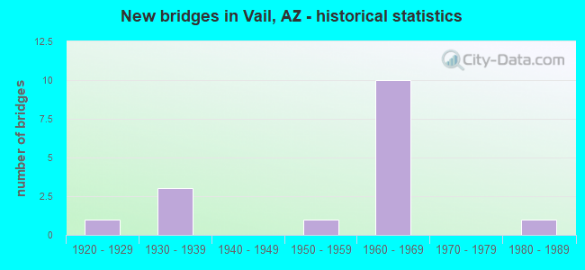
- New bridges - historical statistics
- 11920-1929
- 31930-1939
- 11950-1959
- 101960-1969
- 11980-1989

- Reconstructed bridges - Historical Statistics
- 11980-1989
- 01990-1999
- 02000-2009
- 12010-2019


- Bridge Condition - Deck
- 33.3%Very good
- 16.7%Good
- 50.0%Satisfactory

- Bridge Condition - Superstructure
- 16.7%Very good
- 33.3%Good
- 33.3%Satisfactory
- 16.7%Fair

- Bridge Condition - Substructure
- 33.3%Good
- 50.0%Satisfactory
- 16.7%Fair

- Bridge Condition - Channel
- 9.1%Very good
- 63.6%Good
- 9.1%Satisfactory
- 18.2%Fair

- Bridge Condition - Culverts
- 71.4%Good
- 28.6%Satisfactory
Find on map >> Show street view
Structure Number: 598, Location: 2.7 mi E Jct SR 83 (Lat: 31.997500, Lng: -110.646600), Route carried "on" structure: Interstate 10, Year Built: 1961, Year Reconstructed: 2016, Status: Open, Structure Length: 11.06m (36.29ft), Average Daily Traffic: 24,549 (year 2020), Truck Traffic: 30%, Average Future Daily Traffic: 24,559 (year 2040), Design Load: HL 93, Features Intersected: Davidson Canyon
Minimum Vertical Clearance: 30+ m (98+ ft), Kilometerpoint: 457.778, Lanes on structure: 2, Owner: State Highway Agency, Approaching Roadway Width: 12.8m (42.0ft), Material/Design: Prestressed concrete continuous, Design/Construction: Stringer/Multi-beam, Number Of Spans In Main Unit: 3, Length of Maximum Span: 36.6m (120.1ft), Curb-To-Curb Width: 12.8m (42.0ft), Out-to-Out Width: 13.7m (44.9ft)
Condition: Deck: Very good, Superstructure: Very good, Substructure: Good, Channel: Good, Operating Rating: 89.8 metric tons, Method Used To Determine Operating Rating: Load Factor (LF), Inventory Rating: 32.7 metric tons, Method Used To Determine Inventory Rating: Load Factor (LF), Structural Evaluation: Better than present minimum criteria, Deck Geometry: Equal to present desirable criteria, Waterway Adequacy: Equal to present desirable criteria, Approach Roadway Alignment: Equal to present desirable criteria, Designated Inspection Frequency: Every 24 months, Inspection Date: January 2022, Deck Structure Type: Concrete Cast-file-Place, Wearing Surface/Protective System: Wearing Surface: Monolithic Concrete
Find on map >> Show street view
Structure Number: 744, Location: 2.3 mi W Jct SR 83 (Lat: 32.027400, Lng: -110.720700), Route carried "on" structure: County highway , Year Built: 1962, Status: Open, Structure Length: 4.88m (16.01ft), Average Daily Traffic: 2,390 (year 2019), Truck Traffic: 5%, Average Future Daily Traffic: 2,400 (year 2039), Design Load: HS 20, Features Intersected: I 10;EB Lanes, Facility Carried by Structure: Vail Road
Minimum Vertical Clearance: 30+ m (98+ ft), Kilometerpoint: 0.000, Lanes on structure: 2, Lanes under structure: 2, Owner: State Highway Agency, Approaching Roadway Width: 9.1m (29.9ft), Skew: 2 degrees, Material/Design: Steel continuous, Design/Construction: Stringer/Multi-beam, Number Of Spans In Main Unit: 3, Length of Maximum Span: 18.0m (59.1ft), Curb-To-Curb Width: 9.1m (29.9ft), Out-to-Out Width: 10.7m (35.1ft)
Condition: Deck: Very good, Superstructure: Satisfactory, Substructure: Satisfactory, Operating Rating: 55.3 metric tons, Method Used To Determine Operating Rating: Load Factor (LF), Inventory Rating: 33.6 metric tons, Method Used To Determine Inventory Rating: Load Factor (LF), Structural Evaluation: Equal to present minimum criteria, Deck Geometry: Meets minimum limits, Underclear: High priority of corrective action, Approach Roadway Alignment: Equal to present desirable criteria, Designated Inspection Frequency: Every 24 months, Inspection Date: October 2020, Deck Structure Type: Concrete Cast-file-Place, Wearing Surface/Protective System: Wearing Surface: Monolithic Concrete
Find on map >> Show street view
Structure Number: 745, Location: 2.3 mi W Jct SR 83 (Lat: 32.028600, Lng: -110.720400), Route carried "on" structure: County highway , Year Built: 1962, Status: Open, Structure Length: 4.88m (16.01ft), Average Daily Traffic: 2,390 (year 2019), Truck Traffic: 5%, Average Future Daily Traffic: 2,400 (year 2039), Design Load: HS 20, Features Intersected: I 10;WB, Facility Carried by Structure: Vail Road
Minimum Vertical Clearance: 30+ m (98+ ft), Kilometerpoint: 0.000, Lanes on structure: 2, Lanes under structure: 2, Owner: State Highway Agency, Approaching Roadway Width: 9.1m (29.9ft), Skew: 2 degrees, Material/Design: Steel continuous, Design/Construction: Stringer/Multi-beam, Number Of Spans In Main Unit: 3, Length of Maximum Span: 18.0m (59.1ft), Curb-To-Curb Width: 9.1m (29.9ft), Out-to-Out Width: 10.7m (35.1ft)
Condition: Deck: Good, Superstructure: Good, Substructure: Satisfactory, Operating Rating: 56.2 metric tons, Method Used To Determine Operating Rating: Load Factor (LF), Inventory Rating: 33.6 metric tons, Method Used To Determine Inventory Rating: Load Factor (LF), Structural Evaluation: Equal to present minimum criteria, Deck Geometry: Meets minimum limits, Underclear: High priority of corrective action, Approach Roadway Alignment: Equal to present desirable criteria, Designated Inspection Frequency: Every 24 months, Inspection Date: May 2020, Deck Structure Type: Concrete Cast-file-Place, Wearing Surface/Protective System: Wearing Surface: Monolithic Concrete
Find on map >> Show street view
Structure Number: 1784, Location: 2.7 mi E Jct SR 83 (Lat: 31.996997, Lng: -110.646442), Route carried "on" structure: Interstate 10, Year Built: 1981, Status: Open, Structure Length: 9.88m (32.41ft), Average Daily Traffic: 24,549 (year 2020), Truck Traffic: 30%, Average Future Daily Traffic: 24,559 (year 2040), Design Load: HS 20, Features Intersected: Davidson Canyon
Minimum Vertical Clearance: 30+ m (98+ ft), Kilometerpoint: 457.778, Lanes on structure: 2, Owner: State Highway Agency, Approaching Roadway Width: 11.6m (38.1ft), Material/Design: Prestressed concrete continuous, Design/Construction: Stringer/Multi-beam, Number Of Spans In Main Unit: 4, Length of Maximum Span: 24.7m (81.0ft), Curb-To-Curb Width: 12.8m (42.0ft), Out-to-Out Width: 13.8m (45.3ft)
Condition: Deck: Satisfactory, Superstructure: Good, Substructure: Good, Channel: Good, Operating Rating: 64.4 metric tons, Method Used To Determine Operating Rating: Load Factor (LF), Inventory Rating: 32.7 metric tons, Method Used To Determine Inventory Rating: Load Factor (LF), Structural Evaluation: Better than present minimum criteria, Deck Geometry: Equal to present desirable criteria, Waterway Adequacy: Better than present minimum criteria, Approach Roadway Alignment: Equal to present desirable criteria, Designated Inspection Frequency: Every 24 months, Inspection Date: January 2022, Deck Structure Type: Concrete Cast-file-Place, Wearing Surface/Protective System: Wearing Surface: Bituminous
Find on map >> Show street view
Structure Number: 4536, Location: 4.5 mi S Jct I 10 (Lat: 31.955200, Lng: -110.668700), Route carried "on" structure: State highway 83, Year Built: 1966, Status: Open, Structure Length: 0.64m (2.10ft), Average Daily Traffic: 2,301 (year 2018), Truck Traffic: 8%, Average Future Daily Traffic: 2,311 (year 2038), Design Load: HS 20, Features Intersected: Wash
Minimum Vertical Clearance: 30+ m (98+ ft), Kilometerpoint: 86.599, Lanes on structure: 2, Owner: State Highway Agency, Approaching Roadway Width: 8.8m (28.9ft), Material/Design: Concrete continuous, Design/Construction: Culvert, Number Of Spans In Main Unit: 2, Length of Maximum Span: 3.0m (9.8ft)
Condition: Channel: Very good, Culverts: Good, Operating Rating: 64.4 metric tons, Method Used To Determine Operating Rating: Load Factor (LF), Inventory Rating: 38.1 metric tons, Method Used To Determine Inventory Rating: Load Factor (LF), Structural Evaluation: Better than present minimum criteria, Waterway Adequacy: Equal to present desirable criteria, Approach Roadway Alignment: Equal to present desirable criteria, Designated Inspection Frequency: Every 48 months, Inspection Date: April 2020
Find on map >> Show street view
Structure Number: 4537, Location: 2.5 mi S Jct I 10 (Lat: 31.970000, Lng: -110.674800), Route carried "on" structure: State highway 83, Year Built: 1966, Status: Open, Structure Length: 2.68m (8.79ft), Average Daily Traffic: 3,634 (year 2018), Truck Traffic: 12%, Average Future Daily Traffic: 4,413 (year 2038), Design Load: HS 20, Features Intersected: Wash
Minimum Vertical Clearance: 30+ m (98+ ft), Kilometerpoint: 89.866, Lanes on structure: 2, Owner: State Highway Agency, Approaching Roadway Width: 8.8m (28.9ft), Skew: 6 degrees, Material/Design: Concrete continuous, Design/Construction: Culvert, Number Of Spans In Main Unit: 4, Length of Maximum Span: 3.0m (9.8ft)
Condition: Channel: Good, Culverts: Satisfactory, Operating Rating: 59.9 metric tons, Method Used To Determine Operating Rating: Load Factor (LF), Inventory Rating: 35.4 metric tons, Method Used To Determine Inventory Rating: Load Factor (LF), Structural Evaluation: Equal to present minimum criteria, Waterway Adequacy: Equal to present desirable criteria, Approach Roadway Alignment: Equal to present desirable criteria, Designated Inspection Frequency: Every 48 months, Inspection Date: April 2020
Find on map >> Show street view
Structure Number: 4538, Location: 1.8 mi S Jct I 10 (Lat: 31.981800, Lng: -110.679700), Route carried "on" structure: State highway 83, Year Built: 1966, Status: Open, Structure Length: 0.91m (2.99ft), Average Daily Traffic: 3,624 (year 2018), Truck Traffic: 12%, Average Future Daily Traffic: 3,634 (year 2038), Design Load: HS 20, Features Intersected: Wash
Minimum Vertical Clearance: 30+ m (98+ ft), Kilometerpoint: 91.234, Lanes on structure: 2, Owner: State Highway Agency, Approaching Roadway Width: 8.8m (28.9ft), Skew: 4 degrees, Material/Design: Concrete continuous, Design/Construction: Culvert, Number Of Spans In Main Unit: 2, Length of Maximum Span: 3.0m (9.8ft)
Condition: Channel: Good, Culverts: Good, Operating Rating: 89.8 metric tons, Method Used To Determine Operating Rating: Load Factor (LF), Inventory Rating: 71.7 metric tons, Method Used To Determine Inventory Rating: Load Factor (LF), Structural Evaluation: Better than present minimum criteria, Waterway Adequacy: Equal to present desirable criteria, Approach Roadway Alignment: Equal to present desirable criteria, Designated Inspection Frequency: Every 48 months, Inspection Date: April 2020
Find on map >> Show street view
Structure Number: 5557, Location: 18.1 mi E Jct SR B10 (Lat: 31.997900, Lng: -110.632200), Route carried "on" structure: Interstate 10, Year Built: 1955, Status: Open, Structure Length: 0.64m (2.10ft), Average Daily Traffic: 12,275 (year 2020), Truck Traffic: 17%, Average Future Daily Traffic: 12,285 (year 2040), Design Load: HS 20, Features Intersected: Blue Nob Canyon
Minimum Vertical Clearance: 30+ m (98+ ft), Kilometerpoint: 459.240, Lanes on structure: 2, Owner: State Highway Agency, Approaching Roadway Width: 11.6m (38.1ft), Material/Design: Concrete continuous, Design/Construction: Culvert, Number Of Spans In Main Unit: 2, Length of Maximum Span: 3.0m (9.8ft)
Condition: Channel: Fair, Culverts: Good, Operating Rating: 89.8 metric tons, Method Used To Determine Operating Rating: Load Factor (LF), Inventory Rating: 68.0 metric tons, Method Used To Determine Inventory Rating: Load Factor (LF), Structural Evaluation: Better than present minimum criteria, Waterway Adequacy: Equal to present desirable criteria, Approach Roadway Alignment: Equal to present desirable criteria, Designated Inspection Frequency: Every 48 months, Inspection Date: November 2021
Find on map >> Show street view
Structure Number: 5558, Location: 18.1 mi E Jct SR B10 (Lat: 31.999000, Lng: -110.632300), Route carried "on" structure: Interstate 10, Year Built: 1961, Status: Open, Structure Length: 0.64m (2.10ft), Average Daily Traffic: 12,275 (year 2020), Truck Traffic: 17%, Average Future Daily Traffic: 12,285 (year 2040), Design Load: HS 20, Features Intersected: Blue Nob Canyon
Minimum Vertical Clearance: 30+ m (98+ ft), Kilometerpoint: 459.240, Lanes on structure: 2, Owner: State Highway Agency, Approaching Roadway Width: 11.6m (38.1ft), Material/Design: Concrete continuous, Design/Construction: Culvert, Number Of Spans In Main Unit: 2, Length of Maximum Span: 3.0m (9.8ft)
Condition: Channel: Good, Culverts: Good, Operating Rating: 89.8 metric tons, Method Used To Determine Operating Rating: Load Factor (LF), Inventory Rating: 68.0 metric tons, Method Used To Determine Inventory Rating: Load Factor (LF), Structural Evaluation: Better than present minimum criteria, Waterway Adequacy: Equal to present desirable criteria, Approach Roadway Alignment: Equal to present desirable criteria, Designated Inspection Frequency: Every 48 months, Inspection Date: November 2021
Find on map >> Show street view
Structure Number: 8292, Location: 8.4 mi N of I 10 Exit 289 (Lat: 32.003339, Lng: -110.671386), Route carried "on" structure: County highway , Year Built: 1933, Status: Open, Structure Length: 0.64m (2.10ft), Average Daily Traffic: 400 (year 2012), Average Future Daily Traffic: 410 (year 2032), Design Load: H 20, Features Intersected: Medium Wash, Facility Carried by Structure: Marsh Station Rd
Minimum Vertical Clearance: 30+ m (98+ ft), Kilometerpoint: 0.000, Lanes on structure: 2, Owner: County Highway Agency, Approaching Roadway Width: 7.9m (25.9ft), Material/Design: Concrete continuous, Design/Construction: Culvert, Number Of Spans In Main Unit: 2, Length of Maximum Span: 3.0m (9.8ft)
Condition: Channel: Good, Culverts: Satisfactory, Structural Evaluation: Equal to present minimum criteria, Waterway Adequacy: Better than present minimum criteria, Approach Roadway Alignment: Equal to present minimum criteria, Designated Inspection Frequency: Every 48 months, Inspection Date: December 2019
Find on map >> Show street view
Structure Number: 8293, Location: 6.1 mi N Benson Hwy (Lat: 32.019300, Lng: -110.646100), Route carried "on" structure: County highway , Year Built: 1920, Year Reconstructed: 1989, Status: Posted for load, Structure Length: 8.47m (27.79ft), Average Daily Traffic: 627 (year 2021), Average Future Daily Traffic: 637 (year 2041), Design Load: H 15, Features Intersected: Pantano Wash & RR, Facility Carried by Structure: Marsh Station Rd
Minimum Vertical Clearance: 30+ m (98+ ft), Kilometerpoint: 0.000, Lanes on structure: 2, Owner: County Highway Agency, Approaching Roadway Width: 9.4m (30.8ft), Material/Design: Concrete, Design/Construction: Arch - Deck, Number Of Spans In Main Unit: 1, Number Of Approach Spans: 5, Length of Maximum Span: 44.5m (146.0ft), Curb-To-Curb Width: 6.1m (20.0ft), Out-to-Out Width: 7.1m (23.3ft)
Condition: Deck: Satisfactory, Superstructure: Fair, Substructure: Fair, Channel: Good, Operating Rating: 47.2 metric tons, Method Used To Determine Operating Rating: Load Factor (LF), Inventory Rating: 28.1 metric tons, Method Used To Determine Inventory Rating: Load Factor (LF), Structural Evaluation: Somewhat better than minimum adequacy, Deck Geometry: High priority of corrective action, Underclear: Meets minimum limits, Waterway Adequacy: Equal to present desirable criteria, Approach Roadway Alignment: Equal to present minimum criteria, Length Of Structure Improvement: 9.14m (29.99ft), Designated Inspection Frequency: Every 24 months, Inspection Date: October 2021, Deck Structure Type: Concrete Cast-file-Place, Wearing Surface/Protective System: Wearing Surface: Bituminous
Find on map >> Show street view
Structure Number: 8294, Location: 4.7 mi N of I 10 Exit 289 (Lat: 32.023100, Lng: -110.622200), Route carried "on" structure: County highway , Year Built: 1933, Status: Posted for load, Structure Length: 1.10m (3.61ft), Average Daily Traffic: 627 (year 2021), Average Future Daily Traffic: 637 (year 2041), Design Load: H 15, Features Intersected: Medium Wash, Facility Carried by Structure: Marsh Station Rd
Minimum Vertical Clearance: 30+ m (98+ ft), Kilometerpoint: 0.000, Lanes on structure: 2, Owner: County Highway Agency, Approaching Roadway Width: 8.2m (26.9ft), Material/Design: Concrete continuous, Design/Construction: Slab, Number Of Spans In Main Unit: 2, Length of Maximum Span: 4.6m (15.1ft), Curb-To-Curb Width: 7.8m (25.6ft), Out-to-Out Width: 8.3m (27.2ft)
Condition: Deck: Satisfactory, Superstructure: Satisfactory, Substructure: Satisfactory, Channel: Fair, Operating Rating: 38.1 metric tons, Method Used To Determine Operating Rating: Load Factor (LF), Inventory Rating: 22.7 metric tons, Method Used To Determine Inventory Rating: Load Factor (LF), Structural Evaluation: Equal to present minimum criteria, Deck Geometry: Meets minimum limits, Waterway Adequacy: Equal to present minimum criteria, Approach Roadway Alignment: Equal to present minimum criteria, Length Of Structure Improvement: 1.83m (6.00ft), Designated Inspection Frequency: Every 24 months, Inspection Date: October 2021, Total Project Cost: $1,000 ( Estimate for 2021), Deck Structure Type: Concrete Cast-file-Place, Wearing Surface/Protective System: Wearing Surface: Bituminous
Find on map >> Show street view
Structure Number: 8295, Location: 3.7 mi N of I 10 Exit 289 (Lat: 32.018228, Lng: -110.607694), Route carried "on" structure: County highway , Year Built: 1933, Status: Open, Structure Length: 0.64m (2.10ft), Average Daily Traffic: 400 (year 2012), Average Future Daily Traffic: 410 (year 2032), Design Load: HS 20, Features Intersected: Medium Wash, Facility Carried by Structure: Marsh Station Rd
Minimum Vertical Clearance: 30+ m (98+ ft), Kilometerpoint: 0.000, Lanes on structure: 2, Owner: County Highway Agency, Approaching Roadway Width: 7.3m (24.0ft), Material/Design: Concrete continuous, Design/Construction: Culvert, Number Of Spans In Main Unit: 2, Length of Maximum Span: 3.0m (9.8ft), Curb-To-Curb Width: 8.5m (27.9ft), Out-to-Out Width: 9.4m (30.8ft)
Condition: Channel: Satisfactory, Culverts: Good, Operating Rating: 38.1 metric tons, Method Used To Determine Operating Rating: Load Factor (LF), Inventory Rating: 22.7 metric tons, Method Used To Determine Inventory Rating: Load Factor (LF), Structural Evaluation: Equal to present minimum criteria, Deck Geometry: Equal to present minimum criteria, Waterway Adequacy: Equal to present minimum criteria, Approach Roadway Alignment: Equal to present minimum criteria, Designated Inspection Frequency: Every 48 months, Inspection Date: December 2019, Wearing Surface/Protective System: Wearing Surface: Bituminous
Find on map >> Show street view
Structure Number: 744, Location: 2.3 mi W Jct SR 83 (Lat: 32.027400, Lng: -110.720700), Route carried "under" structure: Interstate 10, Year Built: 1962, Structure Length: 0. m, Average Daily Traffic: 21,918 (year 2019), Truck Traffic: 16%, Features Intersected: I 10;EB Lanes, Facility Carried by Structure: Vail Road
Minimum Vertical Clearance: 4.92m (16.14ft), Kilometerpoint: 449.602, Lanes on structure: 2, Lanes under structure: 2, Material/Design: Steel continuous, Design/Construction: Stringer/Multi-beam, Length of Maximum Span: 18.0m (59.1ft)
Find on map >> Show street view
Structure Number: 745, Location: 2.3 mi W Jct SR 83 (Lat: 32.028600, Lng: -110.720400), Route carried "under" structure: Interstate 10, Year Built: 1962, Structure Length: 0. m, Average Daily Traffic: 21,274 (year 2018), Truck Traffic: 19%, Features Intersected: I 10;WB, Facility Carried by Structure: Vail Road
Minimum Vertical Clearance: 4.97m (16.31ft), Kilometerpoint: 449.602, Lanes on structure: 2, Lanes under structure: 2, Material/Design: Steel continuous, Design/Construction: Stringer/Multi-beam, Length of Maximum Span: 18.0m (59.1ft)
Find on map >> Show street view
Structure Number: 1053, Location: Jct SR 83 (Lat: 32.007400, Lng: -110.690300), Route carried "under" structure: Interstate 10, Year Built: 1961, Structure Length: 0. m, Average Daily Traffic: 31,804 (year 2018), Truck Traffic: 19%, Features Intersected: I 10, Facility Carried by Structure: SR 83;Mtn View Rd
Minimum Vertical Clearance: 5.06m (16.60ft), Kilometerpoint: 453.320, Lanes on structure: 2, Lanes under structure: 4, Material/Design: Steel continuous, Design/Construction: Stringer/Multi-beam, Length of Maximum Span: 34.1m (111.9ft)