Bridge Statistics for Union, New York (NY)
Condition, Traffic, Stress, Structural Evaluation, Project Costs
- National Bridge Inventory (NBI) Statistics
- 42Number of bridges
- 666ft / 203mTotal length
- $98,213,000Total costs
- 399,020Total average daily traffic
- 27,376Total average daily truck traffic
- National Bridge Inventory (NBI) Registered Bridges for Union
- No street view available for this location
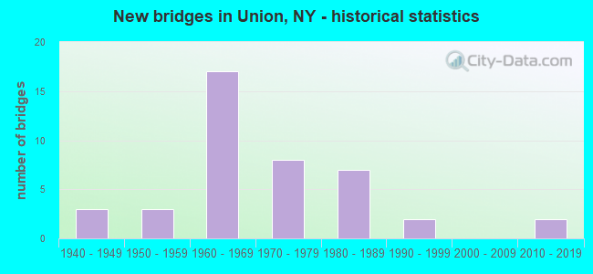
- New bridges - historical statistics
- 31940-1949
- 31950-1959
- 171960-1969
- 81970-1979
- 71980-1989
- 21990-1999
- 22010-2019
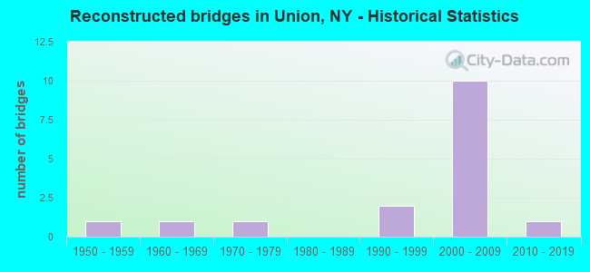
- Reconstructed bridges - Historical Statistics
- 11950-1959
- 11960-1969
- 11970-1979
- 01980-1989
- 21990-1999
- 102000-2009
- 12010-2019
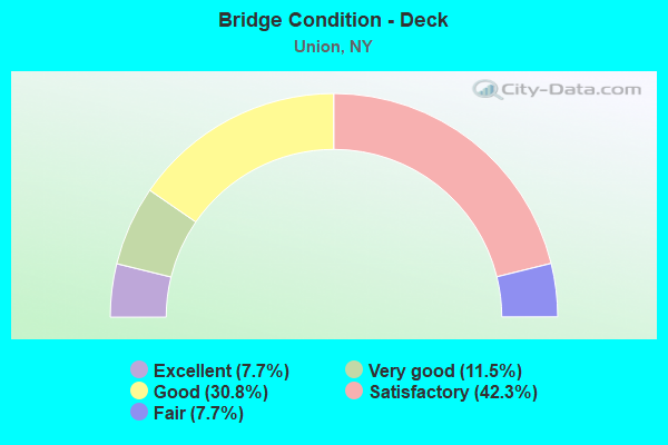
- Bridge Condition - Deck
- 7.7%Excellent
- 11.5%Very good
- 30.8%Good
- 42.3%Satisfactory
- 7.7%Fair
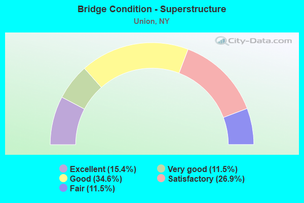
- Bridge Condition - Superstructure
- 15.4%Excellent
- 11.5%Very good
- 34.6%Good
- 26.9%Satisfactory
- 11.5%Fair
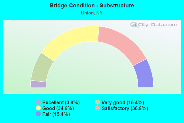
- Bridge Condition - Substructure
- 3.8%Excellent
- 15.4%Very good
- 34.6%Good
- 30.8%Satisfactory
- 15.4%Fair
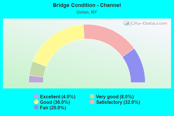
- Bridge Condition - Channel
- 4.0%Excellent
- 8.0%Very good
- 36.0%Good
- 32.0%Satisfactory
- 20.0%Fair
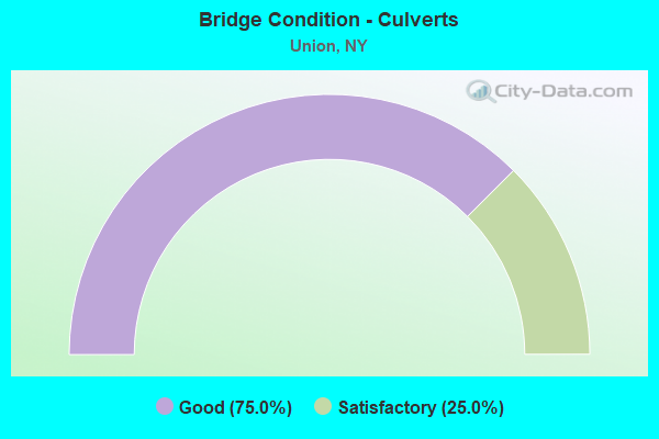
- Bridge Condition - Culverts
- 75.0%Good
- 25.0%Satisfactory
Find on map >> Show street view
Structure Number: 101426, Location: 1.5 MI E WEST BRM CO LINE (Lat: 42.091750, Lng: -76.089778), Route carried "on" structure: State highway 17C, Year Built: 1999, Status: Open, Structure Length: 5.15m (16.90ft), Average Daily Traffic: 9,977 (year 2020), Truck Traffic: 5%, Average Future Daily Traffic: 12,120 (year 2040), Design Load: HS 25 or greater, Features Intersected: NANTICOKE CREEK
Minimum Vertical Clearance: 30+ m (98+ ft), Kilometerpoint: 2.462, Lanes on structure: 2, Base Highway Network: Yes, Owner: State Highway Agency, Approaching Roadway Width: 13.7m (44.9ft), Skew: 20 degrees, Material/Design: Steel, Design/Construction: Stringer/Multi-beam, Number Of Spans In Main Unit: 1, Length of Maximum Span: 50.0m (164.0ft), Curb or Sidewalk Widths: Left: 1.5m (4.9ft), Right: 0.0m, Curb-To-Curb Width: 13.8m (45.3ft), Out-to-Out Width: 16.1m (52.8ft)
Condition: Deck: Satisfactory, Superstructure: Good, Substructure: Good, Channel: Very good, Operating Rating: 86.2 metric tons, Method Used To Determine Operating Rating: Load Factor (LF), Inventory Rating: 51.7 metric tons, Method Used To Determine Inventory Rating: Load Factor (LF), Structural Evaluation: Better than present minimum criteria, Deck Geometry: Superior to present desirable criteria, Waterway Adequacy: Equal to present minimum criteria, Approach Roadway Alignment: Equal to present desirable criteria, Length Of Structure Improvement: 5.15m (16.90ft), Designated Inspection Frequency: Every 24 months, Inspection Date: November 2020, Bridge Improvement Cost: $2,105,000, Roadway Improvement Cost: $1,233,000, Total Project Cost: $3,338,000 ( Estimate for 2021), Deck Structure Type: Concrete Cast-file-Place, Wearing Surface/Protective System: Wearing Surface: Integral Concrete, Deck Protection: Epoxy Coated Reinforcing
Find on map >> Show street view
Structure Number: 101427, Location: 1.7 MI E W BROOME CO LINE (Lat: 42.091925, Lng: -76.086283), Route carried "on" structure: State highway 17C, Year Built: 1999, Status: Open, Structure Length: 8.08m (26.51ft), Average Daily Traffic: 9,977 (year 2020), Truck Traffic: 5%, Average Future Daily Traffic: 12,120 (year 2040), Design Load: HS 25 or greater, Features Intersected: NORFOLK SOUTHERN
Minimum Vertical Clearance: 30+ m (98+ ft), Kilometerpoint: 2.735, Lanes on structure: 2, Base Highway Network: Yes, Owner: State Highway Agency, Approaching Roadway Width: 13.7m (44.9ft), Skew: 3 degrees, Material/Design: Steel continuous, Design/Construction: Stringer/Multi-beam, Number Of Spans In Main Unit: 3, Length of Maximum Span: 39.0m (128.0ft), Curb or Sidewalk Widths: Left: 1.5m (4.9ft), Right: 0.0m, Curb-To-Curb Width: 13.8m (45.3ft), Out-to-Out Width: 16.1m (52.8ft)
Condition: Deck: Good, Superstructure: Very good, Substructure: Very good, Operating Rating: 76.2 metric tons, Method Used To Determine Operating Rating: Load Factor (LF), Inventory Rating: 37.2 metric tons, Method Used To Determine Inventory Rating: Load Factor (LF), Structural Evaluation: Equal to present desirable criteria, Deck Geometry: Superior to present desirable criteria, Underclear: Equal to present minimum criteria, Approach Roadway Alignment: Equal to present desirable criteria, Length Of Structure Improvement: 8.07m (26.48ft), Designated Inspection Frequency: Every 24 months, Inspection Date: November 2021, Bridge Improvement Cost: $3,081,000, Roadway Improvement Cost: $1,804,000, Total Project Cost: $4,886,000 ( Estimate for 2021), Deck Structure Type: Concrete Cast-file-Place, Wearing Surface/Protective System: Wearing Surface: Integral Concrete, Deck Protection: Epoxy Coated Reinforcing
Find on map >> Show street view
Structure Number: 10143, Location: 1.6 MI E JCT RTS 17C + 26 (Lat: 42.107764, Lng: -76.014500), Route carried "on" structure: State highway 17C, Year Built: 2016, Status: Open, Structure Length: 1.74m (5.71ft), Average Daily Traffic: 20,950 (year 2020), Truck Traffic: 3%, Average Future Daily Traffic: 25,450 (year 2040), Design Load: HL 93, Features Intersected: PATTERSON CREEK
Minimum Vertical Clearance: 30+ m (98+ ft), Kilometerpoint: 9.091, Lanes on structure: 4, Base Highway Network: Yes, Owner: State Highway Agency, Approaching Roadway Width: 18.6m (61.0ft), Skew: 1 degrees, Material/Design: Prestressed concrete, Design/Construction: Box Beam or Girders - Multiple, Number Of Spans In Main Unit: 1, Length of Maximum Span: 16.5m (54.1ft), Curb or Sidewalk Widths: Left: 0.0m, Right: 1.6m (5.2ft), Curb-To-Curb Width: 19.4m (63.6ft), Out-to-Out Width: 22.1m (72.5ft)
Condition: Deck: Excellent, Superstructure: Excellent, Substructure: Excellent, Channel: Excellent, Operating Rating: 85.3 metric tons, Method Used To Determine Operating Rating: Load Factor (LF), Inventory Rating: 36.3 metric tons, Method Used To Determine Inventory Rating: Load Factor (LF), Structural Evaluation: Superior to present desirable criteria, Deck Geometry: Better than present minimum criteria, Waterway Adequacy: Equal to present desirable criteria, Approach Roadway Alignment: Equal to present desirable criteria, Length Of Structure Improvement: 1.73m (5.68ft), Designated Inspection Frequency: Every 24 months, Inspection Date: November 2020, Bridge Improvement Cost: $1,247,000, Roadway Improvement Cost: $730,000, Total Project Cost: $1,977,000 ( Estimate for 2021), Deck Structure Type: Concrete Cast-file-Place, Wearing Surface/Protective System: Wearing Surface: Monolithic Concrete, Deck Protection: Epoxy Coated Reinforcing
Find on map >> Show street view
Structure Number: 101846, Location: 1.3 MI N JCT SH26 & SH17C (Lat: 42.112353, Lng: -76.070667), Route carried "on" structure: State highway 26, Year Built: 1969, Status: Posted for load-capacity, Structure Length: 0.88m (2.89ft), Average Daily Traffic: 6,283 (year 2020), Truck Traffic: 7%, Average Future Daily Traffic: 7,632 (year 2040), Design Load: H 20, Features Intersected: WEST CREEK
Minimum Vertical Clearance: 30+ m (98+ ft), Kilometerpoint: 16.460, Lanes on structure: 3, Base Highway Network: Yes, Owner: State Highway Agency, Approaching Roadway Width: 15.2m (49.9ft), Skew: 1 degrees, Material/Design: Concrete continuous, Design/Construction: Culvert, Number Of Spans In Main Unit: 2, Length of Maximum Span: 3.9m (12.8ft), Curb or Sidewalk Widths: Left: 2.1m (6.9ft), Right: 2.3m (7.5ft), Curb-To-Curb Width: 15.2m (49.9ft), Out-to-Out Width: 20.9m (68.6ft)
Condition: Channel: Satisfactory, Culverts: Satisfactory, Operating Rating: 45.4 metric tons, Method Used To Determine Operating Rating: Load Factor (LF), Inventory Rating: 27.2 metric tons, Method Used To Determine Inventory Rating: Load Factor (LF), Structural Evaluation: Equal to present minimum criteria, Deck Geometry: Equal to present minimum criteria, Waterway Adequacy: Somewhat better than minimum adequacy, Approach Roadway Alignment: Equal to present desirable criteria, Length Of Structure Improvement: 0.88m (2.89ft), Designated Inspection Frequency: Every 24 months, Inspection Date: July 2020, Bridge Improvement Cost: $702,000, Roadway Improvement Cost: $411,000, Total Project Cost: $1,113,000 ( Estimate for 2021), Wearing Surface/Protective System: Wearing Surface: Bituminous
Find on map >> Show street view
Structure Number: 1054831, Location: 1.2 MI E JCT SH17 & SH26 (Lat: 42.100069, Lng: -76.025550), Route carried "on" structure: State highway 17, Year Built: 1969, Year Reconstructed: 2009, Status: Open, Structure Length: 30.08m (98.69ft), Average Daily Traffic: 24,003 (year 2011), Truck Traffic: 13%, Average Future Daily Traffic: 33,604 (year 2031), Design Load: HS 20+Mod, Features Intersected: SUSQUEHANNA RIVER
Minimum Vertical Clearance: 30+ m (98+ ft), Kilometerpoint: 7.820, Lanes on structure: 2, Base Highway Network: Yes, Owner: State Highway Agency, Approaching Roadway Width: 12.2m (40.0ft), Skew: 3 degrees, Material/Design: Steel, Design/Construction: Stringer/Multi-beam, Number Of Spans In Main Unit: 7, Length of Maximum Span: 49.4m (162.1ft), Curb-To-Curb Width: 8.5m (27.9ft), Out-to-Out Width: 10.1m (33.1ft)
Condition: Deck: Satisfactory, Superstructure: Good, Substructure: Satisfactory, Channel: Good, Operating Rating: 68.0 metric tons, Method Used To Determine Operating Rating: Load Factor (LF), Inventory Rating: 39.9 metric tons, Method Used To Determine Inventory Rating: Load Factor (LF), Structural Evaluation: Equal to present minimum criteria, Deck Geometry: High priority of corrective action, Waterway Adequacy: Equal to present minimum criteria, Approach Roadway Alignment: Equal to present desirable criteria, Length Of Structure Improvement: 30.08m (98.69ft), Designated Inspection Frequency: Every 24 months, Underwater Inspection Frequency: Every 60 months, Inspection Date: November 2020, Underwater Inspection Date: May 2020, Bridge Improvement Cost: $6,257,000, Roadway Improvement Cost: $3,664,000, Total Project Cost: $9,921,000 ( Estimate for 2021), Deck Structure Type: Concrete Cast-file-Place, Wearing Surface/Protective System: Wearing Surface: Monolithic Concrete
Find on map >> Show street view
Structure Number: 1054832, Location: 1.2 MI E JCT SH 17 & SH 2 (Lat: 42.100631, Lng: -76.023722), Route carried "on" structure: State highway 17, Year Built: 1969, Year Reconstructed: 2009, Status: Open, Structure Length: 30.08m (98.69ft), Average Daily Traffic: 18,715 (year 2011), Truck Traffic: 13%, Average Future Daily Traffic: 21,687 (year 2040), Design Load: HS 20+Mod, Features Intersected: SUSQUEHANNA RIVER
Minimum Vertical Clearance: 30+ m (98+ ft), Kilometerpoint: 7.820, Lanes on structure: 2, Base Highway Network: Yes, Owner: State Highway Agency, Approaching Roadway Width: 12.2m (40.0ft), Skew: 3 degrees, Material/Design: Steel, Design/Construction: Stringer/Multi-beam, Number Of Spans In Main Unit: 7, Length of Maximum Span: 49.4m (162.1ft), Curb-To-Curb Width: 8.5m (27.9ft), Out-to-Out Width: 10.1m (33.1ft)
Condition: Deck: Satisfactory, Superstructure: Good, Substructure: Satisfactory, Channel: Satisfactory, Operating Rating: 54.4 metric tons, Method Used To Determine Operating Rating: Load Factor (LF), Inventory Rating: 32.7 metric tons, Method Used To Determine Inventory Rating: Load Factor (LF), Structural Evaluation: Equal to present minimum criteria, Deck Geometry: High priority of corrective action, Waterway Adequacy: Equal to present minimum criteria, Approach Roadway Alignment: Equal to present desirable criteria, Length Of Structure Improvement: 30.08m (98.69ft), Designated Inspection Frequency: Every 24 months, Underwater Inspection Frequency: Every 60 months, Inspection Date: November 2020, Underwater Inspection Date: May 2020, Bridge Improvement Cost: $6,227,000, Roadway Improvement Cost: $3,647,000, Total Project Cost: $9,874,000 ( Estimate for 2021), Deck Structure Type: Concrete Cast-file-Place, Wearing Surface/Protective System: Wearing Surface: Monolithic Concrete
Find on map >> Show street view
Structure Number: 1054841, Location: 2 MI E JCT SH 17 & SH 26 (Lat: 42.106278, Lng: -76.013886), Route carried "on" structure: State highway 17, Year Built: 1969, Year Reconstructed: 2009, Status: Open, Structure Length: 1.34m (4.40ft), Average Daily Traffic: 24,003 (year 2011), Truck Traffic: 13%, Design Load: HS 20+Mod, Features Intersected: PATTERSON CREEK
Minimum Vertical Clearance: 30+ m (98+ ft), Kilometerpoint: 9.043, Lanes on structure: 2, Base Highway Network: Yes, Owner: State Highway Agency, Approaching Roadway Width: 11.0m (36.1ft), Skew: 2 degrees, Material/Design: Steel, Design/Construction: Stringer/Multi-beam, Number Of Spans In Main Unit: 1, Length of Maximum Span: 11.8m (38.7ft), Curb-To-Curb Width: 11.8m (38.7ft), Out-to-Out Width: 12.8m (42.0ft)
Condition: Deck: Satisfactory, Superstructure: Satisfactory, Substructure: Satisfactory, Channel: Satisfactory, Operating Rating: 58.1 metric tons, Method Used To Determine Operating Rating: Load Factor (LF), Inventory Rating: 34.5 metric tons, Method Used To Determine Inventory Rating: Load Factor (LF), Structural Evaluation: Equal to present minimum criteria, Deck Geometry: Equal to present minimum criteria, Waterway Adequacy: Meets minimum limits, Approach Roadway Alignment: Equal to present desirable criteria, Length Of Structure Improvement: 1.34m (4.40ft), Designated Inspection Frequency: Every 24 months, Inspection Date: October 2020, Bridge Improvement Cost: $1,158,000, Roadway Improvement Cost: $678,000, Total Project Cost: $1,837,000 ( Estimate for 2021), Deck Structure Type: Concrete Cast-file-Place, Wearing Surface/Protective System: Wearing Surface: Monolithic Concrete
Find on map >> Show street view
Structure Number: 1054842, Location: 1.9 MI E JCT SH 17 & SH 2 (Lat: 42.106103, Lng: -76.013786), Route carried "on" structure: State highway 17, Year Built: 1969, Year Reconstructed: 2009, Status: Open, Structure Length: 1.22m (4.00ft), Average Daily Traffic: 18,715 (year 2011), Truck Traffic: 13%, Average Future Daily Traffic: 21,687 (year 2040), Design Load: HS 20+Mod, Features Intersected: PATTERSON CREEK
Minimum Vertical Clearance: 30+ m (98+ ft), Kilometerpoint: 9.043, Lanes on structure: 2, Base Highway Network: Yes, Owner: State Highway Agency, Approaching Roadway Width: 11.0m (36.1ft), Skew: 2 degrees, Material/Design: Steel, Design/Construction: Stringer/Multi-beam, Number Of Spans In Main Unit: 1, Length of Maximum Span: 11.8m (38.7ft), Curb-To-Curb Width: 11.8m (38.7ft), Out-to-Out Width: 12.8m (42.0ft)
Condition: Deck: Satisfactory, Superstructure: Satisfactory, Substructure: Good, Channel: Satisfactory, Operating Rating: 58.1 metric tons, Method Used To Determine Operating Rating: Load Factor (LF), Inventory Rating: 34.5 metric tons, Method Used To Determine Inventory Rating: Load Factor (LF), Structural Evaluation: Equal to present minimum criteria, Deck Geometry: Equal to present minimum criteria, Waterway Adequacy: Superior to present desirable criteria, Approach Roadway Alignment: Equal to present desirable criteria, Length Of Structure Improvement: 1.21m (3.97ft), Designated Inspection Frequency: Every 24 months, Inspection Date: October 2020, Bridge Improvement Cost: $1,144,000, Roadway Improvement Cost: $670,000, Total Project Cost: $1,813,000 ( Estimate for 2021), Deck Structure Type: Concrete Cast-file-Place, Wearing Surface/Protective System: Wearing Surface: Monolithic Concrete
Find on map >> Show street view
Structure Number: 1054851, Location: 2.1 MI E JCT SH 17 & SH 2 (Lat: 42.108075, Lng: -76.011261), Route carried "on" structure: State highway 17, Year Built: 1969, Year Reconstructed: 2009, Status: Open, Structure Length: 4.11m (13.48ft), Average Daily Traffic: 24,003 (year 2011), Truck Traffic: 13%, Average Future Daily Traffic: 33,604 (year 2031), Design Load: HS 20+Mod, Features Intersected: RIVER RD
Minimum Vertical Clearance: 30+ m (98+ ft), Kilometerpoint: 9.316, Lanes on structure: 2, Lanes under structure: 2, Base Highway Network: Yes, Owner: State Highway Agency, Approaching Roadway Width: 11.6m (38.1ft), Skew: 2 degrees, Material/Design: Steel, Design/Construction: Stringer/Multi-beam, Number Of Spans In Main Unit: 3, Length of Maximum Span: 14.6m (47.9ft), Curb-To-Curb Width: 8.5m (27.9ft), Out-to-Out Width: 10.1m (33.1ft)
Condition: Deck: Satisfactory, Superstructure: Fair, Substructure: Satisfactory, Operating Rating: 50.8 metric tons, Method Used To Determine Operating Rating: Load Factor (LF), Inventory Rating: 29.9 metric tons, Method Used To Determine Inventory Rating: Load Factor (LF), Structural Evaluation: Somewhat better than minimum adequacy, Deck Geometry: High priority of replacement, Underclear: Meets minimum limits, Approach Roadway Alignment: Equal to present desirable criteria, Length Of Structure Improvement: 4.11m (13.48ft), Designated Inspection Frequency: Every 24 months, Inspection Date: June 2020, Bridge Improvement Cost: $942,000, Roadway Improvement Cost: $552,000, Total Project Cost: $1,493,000 ( Estimate for 2021), Deck Structure Type: Concrete Cast-file-Place, Wearing Surface/Protective System: Wearing Surface: Monolithic Concrete
Find on map >> Show street view
Structure Number: 1054852, Location: 2.1 MI E JCT SH 17 & SH 2 (Lat: 42.107903, Lng: -76.011169), Route carried "on" structure: State highway 17, Year Built: 1969, Year Reconstructed: 2009, Status: Open, Structure Length: 4.11m (13.48ft), Average Daily Traffic: 18,715 (year 2011), Truck Traffic: 13%, Average Future Daily Traffic: 21,687 (year 2040), Design Load: HS 20+Mod, Features Intersected: RIVER RD
Minimum Vertical Clearance: 30+ m (98+ ft), Kilometerpoint: 9.316, Lanes on structure: 2, Lanes under structure: 2, Base Highway Network: Yes, Owner: State Highway Agency, Approaching Roadway Width: 11.6m (38.1ft), Skew: 2 degrees, Material/Design: Steel, Design/Construction: Stringer/Multi-beam, Number Of Spans In Main Unit: 3, Length of Maximum Span: 14.9m (48.9ft), Curb or Sidewalk Widths: Left: 0.5m (1.6ft), Right: 0.5m (1.6ft), Curb-To-Curb Width: 8.5m (27.9ft), Out-to-Out Width: 10.1m (33.1ft)
Condition: Deck: Satisfactory, Superstructure: Fair, Substructure: Fair, Operating Rating: 50.8 metric tons, Method Used To Determine Operating Rating: Load Factor (LF), Inventory Rating: 29.9 metric tons, Method Used To Determine Inventory Rating: Load Factor (LF), Structural Evaluation: Somewhat better than minimum adequacy, Deck Geometry: High priority of replacement, Underclear: Meets minimum limits, Approach Roadway Alignment: Equal to present desirable criteria, Length Of Structure Improvement: 4.11m (13.48ft), Designated Inspection Frequency: Every 24 months, Inspection Date: October 2020, Bridge Improvement Cost: $942,000, Roadway Improvement Cost: $552,000, Total Project Cost: $1,493,000 ( Estimate for 2021), Deck Structure Type: Concrete Cast-file-Place, Wearing Surface/Protective System: Wearing Surface: Monolithic Concrete
Find on map >> Show street view
Structure Number: 105486, Location: 2 MI E JCT SH 17C & SH 26 (Lat: 42.110750, Lng: -76.007339), Route carried "on" structure: State highway 17C, Year Built: 1968, Year Reconstructed: 2009, Status: Open, Structure Length: 11.16m (36.61ft), Average Daily Traffic: 20,950 (year 2020), Truck Traffic: 3%, Average Future Daily Traffic: 25,450 (year 2040), Design Load: HS 20, Features Intersected: 17 17 91071062 SW, RTE
Minimum Vertical Clearance: 30+ m (98+ ft), Kilometerpoint: 9.767, Lanes on structure: 2, Lanes under structure: 8, Base Highway Network: Yes, Owner: State Highway Agency, Approaching Roadway Width: 13.1m (43.0ft), Skew: 5 degrees, Material/Design: Steel, Design/Construction: Stringer/Multi-beam, Number Of Spans In Main Unit: 4, Length of Maximum Span: 29.8m (97.8ft), Curb or Sidewalk Widths: Left: 0.5m (1.6ft), Right: 0.5m (1.6ft), Curb-To-Curb Width: 8.5m (27.9ft), Out-to-Out Width: 10.1m (33.1ft)
Condition: Deck: Good, Superstructure: Good, Substructure: Good, Operating Rating: 78.9 metric tons, Method Used To Determine Operating Rating: Load Factor (LF), Inventory Rating: 47.2 metric tons, Method Used To Determine Inventory Rating: Load Factor (LF), Structural Evaluation: Better than present minimum criteria, Deck Geometry: Meets minimum limits, Underclear: High priority of corrective action, Approach Roadway Alignment: Equal to present desirable criteria, Length Of Structure Improvement: 11.15m (36.58ft), Designated Inspection Frequency: Every 24 months, Inspection Date: October 2021, Bridge Improvement Cost: $2,509,000, Roadway Improvement Cost: $1,469,000, Total Project Cost: $3,979,000 ( Estimate for 2021), Deck Structure Type: Concrete Cast-file-Place, Wearing Surface/Protective System: Wearing Surface: Integral Concrete, Deck Protection: Epoxy Coated Reinforcing
Find on map >> Show street view
Structure Number: 1063161, Location: .9 MI W JCT SH17 & SH201 (Lat: 42.118731, Lng: -75.985444), Route carried "on" structure: State highway 17, Year Built: 1971, Year Reconstructed: 2003, Status: Open, Structure Length: 23.47m (77.00ft), Average Daily Traffic: 21,721 (year 2014), Truck Traffic: 10%, Design Load: HS 20+Mod, Features Intersected: RTE 17C, N-S RR
Minimum Vertical Clearance: 30+ m (98+ ft), Kilometerpoint: 11.714, Lanes on structure: 3, Lanes under structure: 2, Base Highway Network: Yes, Owner: State Highway Agency, Approaching Roadway Width: 14.3m (46.9ft), Material/Design: Steel, Design/Construction: Stringer/Multi-beam, Number Of Spans In Main Unit: 8, Length of Maximum Span: 39.0m (128.0ft), Curb-To-Curb Width: 13.4m (44.0ft), Out-to-Out Width: 14.3m (46.9ft)
Condition: Deck: Good, Superstructure: Good, Substructure: Good, Operating Rating: 48.1 metric tons, Method Used To Determine Operating Rating: Load Factor (LF), Inventory Rating: 29.0 metric tons, Method Used To Determine Inventory Rating: Load Factor (LF), Structural Evaluation: Better than present minimum criteria, Deck Geometry: Meets minimum limits, Underclear: Meets minimum limits, Approach Roadway Alignment: Equal to present desirable criteria, Length Of Structure Improvement: 23.46m (76.97ft), Designated Inspection Frequency: Every 24 months, Inspection Date: November 2021, Bridge Improvement Cost: $6,929,000, Roadway Improvement Cost: $4,058,000, Total Project Cost: $10,987,000 ( Estimate for 2021), Deck Structure Type: Concrete Cast-file-Place, Wearing Surface/Protective System: Wearing Surface: Bituminous, Membrane: Other
Find on map >> Show street view
Structure Number: 1063162, Location: .9 MI W JCT SH17 & SH201 (Lat: 42.118686, Lng: -75.984839), Route carried "on" structure: State highway 17, Year Built: 1971, Year Reconstructed: 2003, Status: Open, Structure Length: 23.47m (77.00ft), Average Daily Traffic: 23,214 (year 2014), Truck Traffic: 10%, Average Future Daily Traffic: 26,900 (year 2040), Design Load: HS 20+Mod, Features Intersected: RTE 17C, N-S RR
Minimum Vertical Clearance: 30+ m (98+ ft), Kilometerpoint: 11.714, Lanes on structure: 3, Lanes under structure: 2, Base Highway Network: Yes, Owner: State Highway Agency, Approaching Roadway Width: 15.8m (51.8ft), Material/Design: Steel, Design/Construction: Stringer/Multi-beam, Number Of Spans In Main Unit: 8, Length of Maximum Span: 39.0m (128.0ft), Curb-To-Curb Width: 13.4m (44.0ft), Out-to-Out Width: 14.3m (46.9ft)
Condition: Deck: Good, Superstructure: Good, Substructure: Good, Operating Rating: 49.0 metric tons, Method Used To Determine Operating Rating: Load Factor (LF), Inventory Rating: 29.0 metric tons, Method Used To Determine Inventory Rating: Load Factor (LF), Structural Evaluation: Better than present minimum criteria, Deck Geometry: Meets minimum limits, Underclear: Meets minimum limits, Approach Roadway Alignment: Equal to present desirable criteria, Length Of Structure Improvement: 23.46m (76.97ft), Designated Inspection Frequency: Every 24 months, Inspection Date: November 2021, Bridge Improvement Cost: $6,949,000, Roadway Improvement Cost: $4,069,000, Total Project Cost: $11,018,000 ( Estimate for 2021), Deck Structure Type: Concrete Cast-file-Place, Wearing Surface/Protective System: Wearing Surface: Bituminous, Membrane: Other
Find on map >> Show street view
Structure Number: 1063269, Location: JCT RTS 201 + 17C (Lat: 42.114092, Lng: -75.969653), Route carried "on" structure: US 201, Year Built: 1971, Status: Open, Structure Length: 14.08m (46.19ft), Average Daily Traffic: 2,259 (year 2017), Truck Traffic: 4%, Average Future Daily Traffic: 2,617 (year 2040), Design Load: H 20, Features Intersected: LITTLE CHOCONUT CREEK
Minimum Vertical Clearance: 30+ m (98+ ft), Kilometerpoint: 0.161, Lanes on structure: 4, Base Highway Network: Yes, Owner: State Highway Agency, Approaching Roadway Width: 15.2m (49.9ft), Skew: 30 degrees, Material/Design: Steel, Design/Construction: Stringer/Multi-beam, Number Of Spans In Main Unit: 5, Length of Maximum Span: 33.2m (108.9ft), Curb or Sidewalk Widths: Left: 0.5m (1.6ft), Right: 0.5m (1.6ft), Curb-To-Curb Width: 15.2m (49.9ft), Out-to-Out Width: 17.7m (58.1ft)
Condition: Deck: Satisfactory, Superstructure: Satisfactory, Substructure: Satisfactory, Channel: Good, Operating Rating: 73.0 metric tons, Method Used To Determine Operating Rating: Field evaluation and documented engineering judgment, Inventory Rating: 27.9 metric tons, Method Used To Determine Inventory Rating: Field evaluation and documented engineering judgment, Structural Evaluation: Equal to present minimum criteria, Deck Geometry: High priority of replacement, Waterway Adequacy: Equal to present minimum criteria, Approach Roadway Alignment: Equal to present desirable criteria, Length Of Structure Improvement: 14.08m (46.19ft), Designated Inspection Frequency: Every 24 months, Inspection Date: July 2020, Bridge Improvement Cost: $5,286,000, Roadway Improvement Cost: $3,096,000, Total Project Cost: $8,382,000 ( Estimate for 2021), Deck Structure Type: Concrete Cast-file-Place, Wearing Surface/Protective System: Wearing Surface: Monolithic Concrete
Find on map >> Show street view
Structure Number: 106327, Location: JCT SH 17C & SH 201 (Lat: 42.115511, Lng: -75.969381), Route carried "on" structure: State highway 17C, Year Built: 1970, Status: Open, Structure Length: 1.16m (3.81ft), Average Daily Traffic: 7,986 (year 2014), Truck Traffic: 2%, Average Future Daily Traffic: 9,701 (year 2040), Design Load: HS 20, Features Intersected: LITTLE CHOCONUT CREEK
Minimum Vertical Clearance: 30+ m (98+ ft), Kilometerpoint: 13.194, Lanes on structure: 5, Base Highway Network: Yes, Owner: State Highway Agency, Approaching Roadway Width: 21.9m (71.9ft), Skew: 1 degrees, Material/Design: Concrete continuous, Design/Construction: Culvert, Number Of Spans In Main Unit: 2, Length of Maximum Span: 5.2m (17.1ft), Curb or Sidewalk Widths: Left: 2.4m (7.9ft), Right: 0.5m (1.6ft)
Condition: Channel: Fair, Culverts: Satisfactory, Inventory Rating: 62.6 metric tons, Method Used To Determine Inventory Rating: Load Factor (LF), Structural Evaluation: Equal to present minimum criteria, Waterway Adequacy: Meets minimum limits, Approach Roadway Alignment: Equal to present desirable criteria, Length Of Structure Improvement: 1.15m (3.77ft), Designated Inspection Frequency: Every 24 months, Inspection Date: September 2020, Bridge Improvement Cost: $450,000, Roadway Improvement Cost: $264,000, Total Project Cost: $714,000 ( Estimate for 2021)
Find on map >> Show street view
Structure Number: 106343, Location: .7 MI N JCT SH 26 & SH 17 (Lat: 42.106722, Lng: -76.067589), Route carried "on" structure: State highway 26, Year Built: 1969, Status: Open, Structure Length: 5.33m (17.49ft), Average Daily Traffic: 10,859 (year 2020), Truck Traffic: 4%, Average Future Daily Traffic: 13,191 (year 2040), Design Load: H 20, Features Intersected: NANTICOKE CREEK
Minimum Vertical Clearance: 30+ m (98+ ft), Kilometerpoint: 15.704, Lanes on structure: 3, Base Highway Network: Yes, Owner: State Highway Agency, Approaching Roadway Width: 15.2m (49.9ft), Skew: 2 degrees, Material/Design: Steel, Design/Construction: Stringer/Multi-beam, Number Of Spans In Main Unit: 2, Length of Maximum Span: 25.6m (84.0ft), Curb or Sidewalk Widths: Left: 1.5m (4.9ft), Right: 1.5m (4.9ft), Curb-To-Curb Width: 15.2m (49.9ft), Out-to-Out Width: 19.1m (62.7ft)
Condition: Deck: Satisfactory, Superstructure: Good, Substructure: Satisfactory, Channel: Satisfactory, Operating Rating: 55.7 metric tons, Method Used To Determine Operating Rating: Load and Resistance Factor Rating (LRFR) rating reported by rating factor(RF) method using HL-93 loadings, Inventory Rating: 42.8 metric tons, Method Used To Determine Inventory Rating: Load and Resistance Factor Rating (LRFR) rating reported by rating factor(RF) method using HL-93 loadings, Structural Evaluation: Equal to present minimum criteria, Deck Geometry: Equal to present minimum criteria, Waterway Adequacy: Somewhat better than minimum adequacy, Approach Roadway Alignment: Equal to present desirable criteria, Length Of Structure Improvement: 5.33m (17.49ft), Designated Inspection Frequency: Every 24 months, Underwater Inspection Frequency: Every 60 months, Inspection Date: June 2021, Underwater Inspection Date: July 2012, Bridge Improvement Cost: $2,644,000, Roadway Improvement Cost: $1,548,000, Total Project Cost: $4,192,000 ( Estimate for 2021), Deck Structure Type: Concrete Cast-file-Place, Wearing Surface/Protective System: Wearing Surface: Integral Concrete
Find on map >> Show street view
Structure Number: 107298, Location: 0.1MI.S.INTER.RTES201&17C (Lat: 42.113856, Lng: -75.968794), Route carried "on" structure: Ramp Other road , Year Built: 1986, Status: Open, Structure Length: 4.72m (15.49ft), Average Daily Traffic: 2,207 (year 2017), Truck Traffic: 2%, Average Future Daily Traffic: 2,557 (year 2040), Design Load: HS 20, Features Intersected: RIVERSIDE DRIVE, Facility Carried by Structure: RAMP-RTS17C TO201
Minimum Vertical Clearance: 30+ m (98+ ft), Kilometerpoint: 0.225, Lanes on structure: 1, Lanes under structure: 2, Owner: State Highway Agency, Approaching Roadway Width: 7.9m (25.9ft), Material/Design: Steel continuous, Design/Construction: Stringer/Multi-beam, Number Of Spans In Main Unit: 3, Length of Maximum Span: 20.4m (66.9ft), Curb-To-Curb Width: 7.7m (25.3ft), Out-to-Out Width: 8.8m (28.9ft)
Condition: Deck: Satisfactory, Superstructure: Satisfactory, Substructure: Fair, Operating Rating: 80.4 metric tons, Method Used To Determine Operating Rating: Field evaluation and documented engineering judgment, Inventory Rating: 32.7 metric tons, Method Used To Determine Inventory Rating: Field evaluation and documented engineering judgment, Structural Evaluation: Somewhat better than minimum adequacy, Deck Geometry: Better than present minimum criteria, Underclear: Equal to present minimum criteria, Approach Roadway Alignment: Equal to present desirable criteria, Length Of Structure Improvement: 4.72m (15.49ft), Designated Inspection Frequency: Every 24 months, Inspection Date: May 2020, Bridge Improvement Cost: $1,014,000, Roadway Improvement Cost: $594,000, Total Project Cost: $1,608,000 ( Estimate for 2021), Deck Structure Type: Concrete Cast-file-Place, Wearing Surface/Protective System: Wearing Surface: Integral Concrete, Deck Protection: Epoxy Coated Reinforcing
Find on map >> Show street view
Structure Number: 107299, Location: 0.1MI.S.INTER.RTES291&17C (Lat: 42.114186, Lng: -75.968825), Route carried "on" structure: Ramp Other road , Year Built: 1986, Status: Open, Structure Length: 4.08m (13.39ft), Average Daily Traffic: 2,259 (year 2017), Truck Traffic: 4%, Average Future Daily Traffic: 2,617 (year 2040), Design Load: HS 20, Features Intersected: RIVERSIDE DRIVE, Facility Carried by Structure: RAMPRT201 TO 17C
Minimum Vertical Clearance: 30+ m (98+ ft), Kilometerpoint: 0.113, Lanes on structure: 1, Lanes under structure: 2, Owner: State Highway Agency, Approaching Roadway Width: 7.6m (24.9ft), Material/Design: Steel continuous, Design/Construction: Stringer/Multi-beam, Number Of Spans In Main Unit: 3, Length of Maximum Span: 18.5m (60.7ft), Curb-To-Curb Width: 7.7m (25.3ft), Out-to-Out Width: 8.8m (28.9ft)
Condition: Deck: Good, Superstructure: Satisfactory, Substructure: Satisfactory, Operating Rating: 79.3 metric tons, Method Used To Determine Operating Rating: Field evaluation and documented engineering judgment, Inventory Rating: 32.7 metric tons, Method Used To Determine Inventory Rating: Field evaluation and documented engineering judgment, Structural Evaluation: Equal to present minimum criteria, Deck Geometry: Better than present minimum criteria, Underclear: Equal to present minimum criteria, Approach Roadway Alignment: Equal to present desirable criteria, Length Of Structure Improvement: 4.08m (13.39ft), Designated Inspection Frequency: Every 24 months, Inspection Date: April 2020, Bridge Improvement Cost: $913,000, Roadway Improvement Cost: $535,000, Total Project Cost: $1,448,000 ( Estimate for 2021), Deck Structure Type: Concrete Cast-file-Place, Wearing Surface/Protective System: Wearing Surface: Integral Concrete, Deck Protection: Epoxy Coated Reinforcing
Find on map >> Show street view
Structure Number: 222569, Location: 1.5 MI N. Johnson City (Lat: 42.142928, Lng: -75.941728), Route carried "on" structure: Other road , Year Built: 1974, Status: Open, Structure Length: 1.01m (3.31ft), Average Daily Traffic: 3,860 (year 2017), Truck Traffic: 3%, Average Future Daily Traffic: 4,775 (year 2040), Features Intersected: LITTLE CHOCONUT CK, Facility Carried by Structure: COUNTY ROAD 72
Minimum Vertical Clearance: 30+ m (98+ ft), Kilometerpoint: 0.129, Lanes on structure: 4, Owner: County Highway Agency, Approaching Roadway Width: 14.6m (47.9ft), Skew: 4 degrees, Material/Design: Concrete, Design/Construction: Culvert, Number Of Spans In Main Unit: 2, Length of Maximum Span: 3.4m (11.2ft)
Condition: Channel: Fair, Culverts: Good, Structural Evaluation: Better than present minimum criteria, Waterway Adequacy: Equal to present desirable criteria, Approach Roadway Alignment: Equal to present desirable criteria, Length Of Structure Improvement: 0.82m (2.69ft), Designated Inspection Frequency: Every 24 months, Inspection Date: March 2020, Bridge Improvement Cost: $213,000, Roadway Improvement Cost: $125,000, Total Project Cost: $338,000 ( Estimate for 2021)
Find on map >> Show street view
Structure Number: 222574, Location: BTW 17 & 17C OVER PATTERS (Lat: 42.106967, Lng: -76.014072), Route carried "on" structure: Other road , Year Built: 1988, Status: Open, Structure Length: 1.04m (3.41ft), Average Daily Traffic: 134 (year 2018), Truck Traffic: 6%, Average Future Daily Traffic: 188 (year 2038), Features Intersected: PATTERSON CREEK, Facility Carried by Structure: ARGONNE AVENUE
Minimum Vertical Clearance: 30+ m (98+ ft), Kilometerpoint: 0.949, Lanes on structure: 1, Owner: Town or Township Highway Agency, Approaching Roadway Width: 4.9m (16.1ft), Material/Design: Steel, Design/Construction: Culvert, Number Of Spans In Main Unit: 1, Length of Maximum Span: 10.0m (32.8ft)
Condition: Channel: Fair, Culverts: Good, Operating Rating: 79.7 metric tons, Method Used To Determine Operating Rating: Field evaluation and documented engineering judgment, Inventory Rating: 32.7 metric tons, Method Used To Determine Inventory Rating: Field evaluation and documented engineering judgment, Structural Evaluation: Better than present minimum criteria, Waterway Adequacy: Meets minimum limits, Approach Roadway Alignment: Meets minimum limits, Length Of Structure Improvement: 1.03m (3.38ft), Designated Inspection Frequency: Every 24 months, Inspection Date: October 2020, Bridge Improvement Cost: $89,000, Roadway Improvement Cost: $52,000, Total Project Cost: $142,000 ( Estimate for 2021)
Find on map >> Show street view
Structure Number: 222576, Location: 3.0 MILES N OF ENDWELL (Lat: 42.146447, Lng: -76.014019), Route carried "on" structure: Other road , Year Built: 1987, Status: Open, Structure Length: 0.76m (2.49ft), Average Daily Traffic: 1,313 (year 2017), Truck Traffic: 2%, Average Future Daily Traffic: 1,838 (year 2037), Features Intersected: PATTERSON CREEK, Facility Carried by Structure: SALLY PIPER ROAD
Minimum Vertical Clearance: 30+ m (98+ ft), Kilometerpoint: 0.676, Lanes on structure: 2, Owner: Town or Township Highway Agency, Approaching Roadway Width: 9.4m (30.8ft), Material/Design: Steel, Design/Construction: Culvert, Number Of Spans In Main Unit: 1, Length of Maximum Span: 7.3m (24.0ft)
Condition: Channel: Fair, Culverts: Good, Operating Rating: 77.7 metric tons, Method Used To Determine Operating Rating: Field evaluation and documented engineering judgment, Inventory Rating: 32.7 metric tons, Method Used To Determine Inventory Rating: Field evaluation and documented engineering judgment, Structural Evaluation: Better than present minimum criteria, Waterway Adequacy: Somewhat better than minimum adequacy, Approach Roadway Alignment: Meets minimum limits, Length Of Structure Improvement: 0.76m (2.49ft), Designated Inspection Frequency: Every 24 months, Inspection Date: August 2020, Bridge Improvement Cost: $128,000, Roadway Improvement Cost: $75,000, Total Project Cost: $202,000 ( Estimate for 2021)
Find on map >> Show street view
Structure Number: 222578, Location: HAMLET OF ENDWELL (Lat: 42.118428, Lng: -76.019792), Route carried "on" structure: Other road , Year Built: 1970, Status: Open, Structure Length: 1.16m (3.81ft), Average Daily Traffic: 1,451 (year 2016), Truck Traffic: 3%, Average Future Daily Traffic: 2,031 (year 2036), Features Intersected: PATTERSON CREEK, Facility Carried by Structure: SMITH DRIVE
Minimum Vertical Clearance: 30+ m (98+ ft), Kilometerpoint: 1.577, Lanes on structure: 2, Owner: Town or Township Highway Agency, Approaching Roadway Width: 9.1m (29.9ft), Material/Design: Concrete, Design/Construction: Tee Beam, Number Of Spans In Main Unit: 1, Length of Maximum Span: 11.2m (36.7ft), Curb or Sidewalk Widths: Left: 1.2m (3.9ft), Right: 1.2m (3.9ft), Curb-To-Curb Width: 9.2m (30.2ft), Out-to-Out Width: 12.2m (40.0ft)
Condition: Deck: Good, Superstructure: Very good, Substructure: Very good, Channel: Good, Operating Rating: 81.6 metric tons, Method Used To Determine Operating Rating: Load Factor (LF), Inventory Rating: 49.0 metric tons, Method Used To Determine Inventory Rating: Load Factor (LF), Structural Evaluation: Equal to present desirable criteria, Deck Geometry: Somewhat better than minimum adequacy, Waterway Adequacy: Equal to present desirable criteria, Approach Roadway Alignment: Equal to present desirable criteria, Length Of Structure Improvement: 1.15m (3.77ft), Designated Inspection Frequency: Every 24 months, Inspection Date: April 2020, Bridge Improvement Cost: $717,000, Roadway Improvement Cost: $420,000, Total Project Cost: $1,137,000 ( Estimate for 2021), Deck Structure Type: Concrete Cast-file-Place, Wearing Surface/Protective System: Wearing Surface: Bituminous
Find on map >> Show street view
Structure Number: 222579, Location: HAMLET OF ENDWELL (Lat: 42.116178, Lng: -76.019942), Route carried "on" structure: Other road , Year Built: 1949, Year Reconstructed: 2019, Status: Open, Structure Length: 1.55m (5.09ft), Average Daily Traffic: 7,707 (year 2020), Truck Traffic: 3%, Average Future Daily Traffic: 9,535 (year 2040), Features Intersected: PATTERSON CREEK, Facility Carried by Structure: COUNTRY CLUB ROAD
Minimum Vertical Clearance: 30+ m (98+ ft), Kilometerpoint: 1.641, Lanes on structure: 3, Owner: Town or Township Highway Agency, Approaching Roadway Width: 11.0m (36.1ft), Material/Design: Steel, Design/Construction: Stringer/Multi-beam, Number Of Spans In Main Unit: 1, Length of Maximum Span: 14.6m (47.9ft), Curb or Sidewalk Widths: Left: 1.7m (5.6ft), Right: 1.7m (5.6ft), Curb-To-Curb Width: 11.0m (36.1ft), Out-to-Out Width: 15.0m (49.2ft)
Condition: Deck: Excellent, Superstructure: Excellent, Substructure: Good, Channel: Fair, Operating Rating: 77.4 metric tons, Method Used To Determine Operating Rating: Load and Resistance Factor Rating (LRFR) rating reported by rating factor(RF) method using HL-93 loadings, Inventory Rating: 54.8 metric tons, Method Used To Determine Inventory Rating: Load and Resistance Factor Rating (LRFR) rating reported by rating factor(RF) method using HL-93 loadings, Structural Evaluation: Better than present minimum criteria, Deck Geometry: High priority of replacement, Waterway Adequacy: Meets minimum limits, Approach Roadway Alignment: Equal to present desirable criteria, Length Of Structure Improvement: 1.55m (5.09ft), Designated Inspection Frequency: Every 24 months, Inspection Date: September 2021, Bridge Improvement Cost: $969,000, Roadway Improvement Cost: $568,000, Total Project Cost: $1,537,000 ( Estimate for 2021), Deck Structure Type: Other, Wearing Surface/Protective System: Wearing Surface: Integral Concrete
Find on map >> Show street view
Structure Number: 227073, Location: .3 mi NE Nanticoke Dr & B (Lat: 42.151528, Lng: -76.058367), Route carried "on" structure: Other road , Year Built: 2011, Status: Open, Structure Length: 0.88m (2.89ft), Average Daily Traffic: 40 (year 2019), Truck Traffic: 9%, Average Future Daily Traffic: 56 (year 2039), Design Load: HS 25 or greater, Features Intersected: BRADLEY CREEK, Facility Carried by Structure: CARRIE ANNE DRIVE
Minimum Vertical Clearance: 30+ m (98+ ft), Kilometerpoint: 0.016, Lanes on structure: 2, Owner: Town or Township Highway Agency, Approaching Roadway Width: 7.9m (25.9ft), Material/Design: Concrete, Design/Construction: Culvert, Number Of Spans In Main Unit: 2, Length of Maximum Span: 4.3m (14.1ft), Curb-To-Curb Width: 8.8m (28.9ft), Out-to-Out Width: 9.8m (32.2ft)
Condition: Channel: Good, Culverts: Good, Operating Rating: 75.6 metric tons, Method Used To Determine Operating Rating: Field evaluation and documented engineering judgment, Inventory Rating: 40.8 metric tons, Method Used To Determine Inventory Rating: Field evaluation and documented engineering judgment, Structural Evaluation: Better than present minimum criteria, Deck Geometry: Better than present minimum criteria, Waterway Adequacy: Equal to present minimum criteria, Approach Roadway Alignment: High priority of corrective action, Length Of Structure Improvement: 0.88m (2.89ft), Designated Inspection Frequency: Every 24 months, Inspection Date: August 2021, Bridge Improvement Cost: $154,000, Roadway Improvement Cost: $90,000, Total Project Cost: $243,000 ( Estimate for 2021)
Find on map >> Show street view
Structure Number: 334974, Location: HAMLET OF ENDWELL (Lat: 42.108000, Lng: -76.017625), Route carried "on" structure: County highway 33, Year Built: 1964, Year Reconstructed: 2008, Status: Open, Structure Length: 3.75m (12.30ft), Average Daily Traffic: 16,548 (year 2017), Truck Traffic: 3%, Average Future Daily Traffic: 20,102 (year 2040), Design Load: HS 20, Features Intersected: NORFOLK SOUTHERN RR, PAT
Minimum Vertical Clearance: 30+ m (98+ ft), Kilometerpoint: 0.370, Lanes on structure: 3, Owner: County Highway Agency, Approaching Roadway Width: 11.6m (38.1ft), Material/Design: Steel, Design/Construction: Stringer/Multi-beam, Number Of Spans In Main Unit: 2, Length of Maximum Span: 20.1m (65.9ft), Curb or Sidewalk Widths: Left: 1.7m (5.6ft), Right: 0.0m, Curb-To-Curb Width: 11.6m (38.1ft), Out-to-Out Width: 14.5m (47.6ft)
Condition: Deck: Very good, Superstructure: Very good, Substructure: Good, Channel: Very good, Operating Rating: 81.6 metric tons, Method Used To Determine Operating Rating: Load Factor (LF), Inventory Rating: 49.0 metric tons, Method Used To Determine Inventory Rating: Load Factor (LF), Structural Evaluation: Better than present minimum criteria, Deck Geometry: High priority of replacement, Underclear: Somewhat better than minimum adequacy, Waterway Adequacy: Equal to present minimum criteria, Approach Roadway Alignment: Equal to present minimum criteria, Length Of Structure Improvement: 3.74m (12.27ft), Designated Inspection Frequency: Every 24 months, Inspection Date: October 2020, Bridge Improvement Cost: $2,367,000, Roadway Improvement Cost: $1,386,000, Total Project Cost: $3,753,000 ( Estimate for 2021), Deck Structure Type: Concrete Cast-file-Place, Wearing Surface/Protective System: Wearing Surface: Integral Concrete
Find on map >> Show street view
Structure Number: 334975, Location: 1.0 MI N OF ENDWELL (Lat: 42.123931, Lng: -76.022225), Route carried "on" structure: County highway , Year Built: 1944, Year Reconstructed: 1963, Status: Open, Structure Length: 1.37m (4.49ft), Average Daily Traffic: 9,391 (year 2020), Truck Traffic: 4%, Average Future Daily Traffic: 11,408 (year 2040), Design Load: H 20, Features Intersected: PATTERSON CREEK, Facility Carried by Structure: CR33 HOOPER ROAD
Minimum Vertical Clearance: 30+ m (98+ ft), Kilometerpoint: 2.269, Lanes on structure: 2, Owner: County Highway Agency, Approaching Roadway Width: 11.0m (36.1ft), Skew: 4 degrees, Material/Design: Steel, Design/Construction: Stringer/Multi-beam, Number Of Spans In Main Unit: 1, Length of Maximum Span: 12.4m (40.7ft), Curb or Sidewalk Widths: Left: 0.0m, Right: 1.0m (3.3ft), Curb-To-Curb Width: 11.1m (36.4ft), Out-to-Out Width: 13.5m (44.3ft)
Condition: Deck: Fair, Superstructure: Fair, Substructure: Fair, Channel: Satisfactory, Operating Rating: 34.5 metric tons, Method Used To Determine Operating Rating: Load Factor (LF), Inventory Rating: 20.9 metric tons, Method Used To Determine Inventory Rating: Load Factor (LF), Structural Evaluation: Somewhat better than minimum adequacy, Deck Geometry: Meets minimum limits, Waterway Adequacy: Equal to present desirable criteria, Approach Roadway Alignment: Equal to present desirable criteria, Length Of Structure Improvement: 1.37m (4.49ft), Designated Inspection Frequency: Every 24 months, Inspection Date: April 2020, Bridge Improvement Cost: $1,245,000, Roadway Improvement Cost: $729,000, Total Project Cost: $1,974,000 ( Estimate for 2021), Deck Structure Type: Concrete Cast-file-Place, Wearing Surface/Protective System: Wearing Surface: Bituminous
Find on map >> Show street view
Structure Number: 334976, Location: 2.0 MI NW OF ENDICOTT (Lat: 42.114181, Lng: -76.083578), Route carried "on" structure: County highway , Year Built: 1953, Year Reconstructed: 1974, Status: Open, Structure Length: 1.43m (4.69ft), Average Daily Traffic: 4,602 (year 2020), Truck Traffic: 4%, Average Future Daily Traffic: 5,590 (year 2040), Design Load: HS 20, Features Intersected: WEST CREEK, Facility Carried by Structure: DAY HOLLOW ROAD
Minimum Vertical Clearance: 30+ m (98+ ft), Kilometerpoint: 2.558, Lanes on structure: 2, Owner: County Highway Agency, Approaching Roadway Width: 11.0m (36.1ft), Skew: 5 degrees, Material/Design: Steel, Design/Construction: Stringer/Multi-beam, Number Of Spans In Main Unit: 1, Length of Maximum Span: 13.1m (43.0ft), Curb or Sidewalk Widths: Left: 0.0m, Right: 1.2m (3.9ft), Curb-To-Curb Width: 11.0m (36.1ft), Out-to-Out Width: 13.1m (43.0ft)
Condition: Deck: Good, Superstructure: Good, Substructure: Satisfactory, Channel: Good, Operating Rating: 82.6 metric tons, Method Used To Determine Operating Rating: Load Factor (LF), Inventory Rating: 49.0 metric tons, Method Used To Determine Inventory Rating: Load Factor (LF), Structural Evaluation: Equal to present minimum criteria, Deck Geometry: Somewhat better than minimum adequacy, Waterway Adequacy: Somewhat better than minimum adequacy, Approach Roadway Alignment: Equal to present desirable criteria, Length Of Structure Improvement: 1.43m (4.69ft), Designated Inspection Frequency: Every 24 months, Inspection Date: July 2020, Bridge Improvement Cost: $1,170,000, Roadway Improvement Cost: $685,000, Total Project Cost: $1,856,000 ( Estimate for 2021), Deck Structure Type: Concrete Cast-file-Place, Wearing Surface/Protective System: Wearing Surface: Bituminous, Membrane: Other
Find on map >> Show street view
Structure Number: 334977, Location: 2.0 MI NW OF ENDICOTT (Lat: 42.148528, Lng: -76.063144), Route carried "on" structure: County highway , Year Built: 1957, Status: Open, Structure Length: 0.94m (3.08ft), Average Daily Traffic: 3,847 (year 2020), Truck Traffic: 6%, Average Future Daily Traffic: 4,759 (year 2040), Design Load: H 20, Features Intersected: BRADLEY CREEK, Facility Carried by Structure: NANTICOKE DRIVE
Minimum Vertical Clearance: 30+ m (98+ ft), Kilometerpoint: 5.020, Lanes on structure: 2, Owner: County Highway Agency, Approaching Roadway Width: 7.3m (24.0ft), Skew: 2 degrees, Material/Design: Concrete, Design/Construction: Slab, Number Of Spans In Main Unit: 1, Length of Maximum Span: 8.8m (28.9ft), Curb-To-Curb Width: 7.9m (25.9ft), Out-to-Out Width: 8.9m (29.2ft)
Condition: Deck: Good, Superstructure: Good, Substructure: Good, Channel: Good, Operating Rating: 88.0 metric tons, Method Used To Determine Operating Rating: Load Factor (LF), Inventory Rating: 52.6 metric tons, Method Used To Determine Inventory Rating: Load Factor (LF), Structural Evaluation: Better than present minimum criteria, Deck Geometry: High priority of corrective action, Waterway Adequacy: Somewhat better than minimum adequacy, Approach Roadway Alignment: Better than present minimum criteria, Length Of Structure Improvement: 0.94m (3.08ft), Designated Inspection Frequency: Every 24 months, Inspection Date: July 2020, Bridge Improvement Cost: $384,000, Roadway Improvement Cost: $225,000, Total Project Cost: $609,000 ( Estimate for 2021), Wearing Surface/Protective System: Wearing Surface: Bituminous
Find on map >> Show street view
Structure Number: 334978, Location: HAMLET OF UNION CENTER (Lat: 42.149028, Lng: -76.066583), Route carried "on" structure: County highway , Year Built: 1957, Year Reconstructed: 2013, Status: Open, Structure Length: 4.69m (15.39ft), Average Daily Traffic: 3,530 (year 2020), Truck Traffic: 5%, Average Future Daily Traffic: 4,367 (year 2040), Design Load: HS 20, Features Intersected: NANTICOKE CREEK, Facility Carried by Structure: COUNTY ROAD 13
Minimum Vertical Clearance: 30+ m (98+ ft), Kilometerpoint: 5.326, Lanes on structure: 2, Owner: County Highway Agency, Approaching Roadway Width: 7.3m (24.0ft), Skew: 1 degrees, Material/Design: Steel continuous, Design/Construction: Stringer/Multi-beam, Number Of Spans In Main Unit: 3, Length of Maximum Span: 18.2m (59.7ft), Curb-To-Curb Width: 9.4m (30.8ft), Out-to-Out Width: 10.5m (34.4ft)
Condition: Deck: Very good, Superstructure: Excellent, Substructure: Very good, Channel: Good, Operating Rating: 76.2 metric tons, Method Used To Determine Operating Rating: Load Factor (LF), Inventory Rating: 45.4 metric tons, Method Used To Determine Inventory Rating: Load Factor (LF), Structural Evaluation: Equal to present desirable criteria, Deck Geometry: Meets minimum limits, Waterway Adequacy: Somewhat better than minimum adequacy, Approach Roadway Alignment: Equal to present desirable criteria, Length Of Structure Improvement: 4.69m (15.39ft), Designated Inspection Frequency: Every 24 months, Inspection Date: September 2021, Bridge Improvement Cost: $1,010,000, Roadway Improvement Cost: $592,000, Total Project Cost: $1,602,000 ( Estimate for 2021), Deck Structure Type: Concrete Cast-file-Place, Wearing Surface/Protective System: Wearing Surface: Integral Concrete, Deck Protection: Epoxy Coated Reinforcing
Find on map >> Show street view
Structure Number: 334979, Location: HAMLET OF ENDWELL (Lat: 42.110822, Lng: -76.019814), Route carried "on" structure: County highway , Year Built: 1960, Year Reconstructed: 1982, Status: Open, Structure Length: 1.43m (4.69ft), Average Daily Traffic: 6,289 (year 2020), Truck Traffic: 3%, Average Future Daily Traffic: 7,639 (year 2040), Design Load: HS 20, Features Intersected: PATTERSON CREEK, Facility Carried by Structure: WATSON BOULEVARD
Minimum Vertical Clearance: 30+ m (98+ ft), Kilometerpoint: 1.416, Lanes on structure: 2, Owner: Town or Township Highway Agency, Approaching Roadway Width: 11.0m (36.1ft), Material/Design: Steel, Design/Construction: Stringer/Multi-beam, Number Of Spans In Main Unit: 1, Length of Maximum Span: 13.4m (44.0ft), Curb or Sidewalk Widths: Left: 2.0m (6.6ft), Right: 2.0m (6.6ft), Curb-To-Curb Width: 11.0m (36.1ft), Out-to-Out Width: 15.5m (50.9ft)
Condition: Deck: Fair, Superstructure: Satisfactory, Substructure: Fair, Channel: Satisfactory, Operating Rating: 71.7 metric tons, Method Used To Determine Operating Rating: Load Factor (LF), Inventory Rating: 42.6 metric tons, Method Used To Determine Inventory Rating: Load Factor (LF), Structural Evaluation: Somewhat better than minimum adequacy, Deck Geometry: Meets minimum limits, Waterway Adequacy: Somewhat better than minimum adequacy, Approach Roadway Alignment: Equal to present desirable criteria, Length Of Structure Improvement: 1.43m (4.69ft), Designated Inspection Frequency: Every 24 months, Inspection Date: October 2020, Bridge Improvement Cost: $909,000, Roadway Improvement Cost: $532,000, Total Project Cost: $1,441,000 ( Estimate for 2021), Deck Structure Type: Concrete Cast-file-Place, Wearing Surface/Protective System: Wearing Surface: Integral Concrete, Deck Protection: Epoxy Coated Reinforcing
Find on map >> Show street view
Structure Number: 334981, Location: 1.7MI N OF JOHNSON CITY (Lat: 42.156489, Lng: -75.943614), Route carried "on" structure: County highway , Year Built: 1987, Status: Open, Structure Length: 0.79m (2.59ft), Average Daily Traffic: 3,914 (year 2016), Truck Traffic: 8%, Average Future Daily Traffic: 4,754 (year 2040), Design Load: HS 20, Features Intersected: LITTLE CHOCONUT, Facility Carried by Structure: CR69 AIRPORT RD
Minimum Vertical Clearance: 30+ m (98+ ft), Kilometerpoint: 4.280, Lanes on structure: 2, Owner: County Highway Agency, Approaching Roadway Width: 11.6m (38.1ft), Skew: 4 degrees, Material/Design: Steel, Design/Construction: Culvert, Number Of Spans In Main Unit: 1, Length of Maximum Span: 7.6m (24.9ft)
Condition: Channel: Good, Culverts: Good, Operating Rating: 78.0 metric tons, Method Used To Determine Operating Rating: Field evaluation and documented engineering judgment, Inventory Rating: 32.7 metric tons, Method Used To Determine Inventory Rating: Field evaluation and documented engineering judgment, Structural Evaluation: Better than present minimum criteria, Waterway Adequacy: Equal to present minimum criteria, Approach Roadway Alignment: Equal to present desirable criteria, Length Of Structure Improvement: 0.79m (2.59ft), Designated Inspection Frequency: Every 24 months, Inspection Date: June 2020, Bridge Improvement Cost: $163,000, Roadway Improvement Cost: $95,000, Total Project Cost: $258,000 ( Estimate for 2021)
Find on map >> Show street view
Structure Number: 334982, Location: 1.7 MI N OF JOHNSON CITY (Lat: 42.154847, Lng: -75.940697), Route carried "on" structure: County highway , Year Built: 1942, Status: Open, Structure Length: 2.50m (8.20ft), Average Daily Traffic: 475 (year 2020), Truck Traffic: 6%, Average Future Daily Traffic: 665 (year 2040), Features Intersected: LITTLE CHOCONUT CK, Facility Carried by Structure: CR 93
Minimum Vertical Clearance: 30+ m (98+ ft), Kilometerpoint: 1.335, Lanes on structure: 2, Owner: County Highway Agency, Approaching Roadway Width: 7.0m (23.0ft), Skew: 4 degrees, Material/Design: Concrete, Design/Construction: Slab, Number Of Spans In Main Unit: 3, Length of Maximum Span: 11.0m (36.1ft), Curb-To-Curb Width: 7.3m (24.0ft), Out-to-Out Width: 8.2m (26.9ft)
Condition: Deck: Satisfactory, Superstructure: Satisfactory, Substructure: Good, Channel: Good, Operating Rating: 33.6 metric tons, Method Used To Determine Operating Rating: Load Factor (LF), Inventory Rating: 20.0 metric tons, Method Used To Determine Inventory Rating: Load Factor (LF), Structural Evaluation: Somewhat better than minimum adequacy, Deck Geometry: Meets minimum limits, Waterway Adequacy: Meets minimum limits, Approach Roadway Alignment: Somewhat better than minimum adequacy, Length Of Structure Improvement: 2.49m (8.17ft), Designated Inspection Frequency: Every 24 months, Inspection Date: April 2021, Bridge Improvement Cost: $637,000, Roadway Improvement Cost: $373,000, Total Project Cost: $1,011,000 ( Estimate for 2021), Wearing Surface/Protective System: Wearing Surface: Bituminous
Find on map >> Show street view
Structure Number: 335871, Location: IN TOWN OF UNION (Lat: 42.107064, Lng: -76.017719), Route carried "on" structure: County highway , Year Built: 1964, Year Reconstructed: 2014, Status: Open, Structure Length: 4.82m (15.81ft), Average Daily Traffic: 7,916 (year 2017), Truck Traffic: 3%, Average Future Daily Traffic: 9,616 (year 2040), Design Load: HS 25 or greater, Features Intersected: RTE 17C, Facility Carried by Structure: COUNTY ROAD 33
Minimum Vertical Clearance: 30+ m (98+ ft), Kilometerpoint: 0.290, Lanes on structure: 2, Lanes under structure: 4, Owner: County Highway Agency, Approaching Roadway Width: 8.8m (28.9ft), Skew: 2 degrees, Material/Design: Steel, Design/Construction: Stringer/Multi-beam, Number Of Spans In Main Unit: 3, Length of Maximum Span: 25.6m (84.0ft), Curb-To-Curb Width: 8.8m (28.9ft), Out-to-Out Width: 10.1m (33.1ft)
Condition: Deck: Very good, Superstructure: Excellent, Substructure: Very good, Operating Rating: 37.2 metric tons, Method Used To Determine Operating Rating: Load Factor (LF), Inventory Rating: 21.8 metric tons, Method Used To Determine Inventory Rating: Load Factor (LF), Structural Evaluation: Somewhat better than minimum adequacy, Deck Geometry: High priority of replacement, Underclear: Equal to present minimum criteria, Approach Roadway Alignment: Equal to present desirable criteria, Length Of Structure Improvement: 4.81m (15.78ft), Designated Inspection Frequency: Every 24 months, Inspection Date: October 2020, Bridge Improvement Cost: $1,107,000, Roadway Improvement Cost: $648,000, Total Project Cost: $1,755,000 ( Estimate for 2021), Deck Structure Type: Concrete Precast Panels, Wearing Surface/Protective System: Wearing Surface: Integral Concrete
Find on map >> Show street view
Structure Number: 33671, Location: 0.2 MU NE VIL.OF ENDICOTT (Lat: 42.117872, Lng: -76.043125), Route carried "on" structure: Alternate County highway , Year Built: 1966, Status: Open, Structure Length: 0.91m (2.99ft), Average Daily Traffic: 3,304 (year 2020), Truck Traffic: 2%, Average Future Daily Traffic: 4,088 (year 2040), Design Load: HS 20, Features Intersected: BRIXIUS CREEK, Facility Carried by Structure: NEWELL ROAD
Minimum Vertical Clearance: 30+ m (98+ ft), Kilometerpoint: 0.370, Lanes on structure: 2, Owner: Town or Township Highway Agency, Approaching Roadway Width: 11.0m (36.1ft), Material/Design: Steel, Design/Construction: Culvert, Number Of Spans In Main Unit: 1, Length of Maximum Span: 7.6m (24.9ft)
Condition: Channel: Satisfactory, Culverts: Good, Operating Rating: 78.0 metric tons, Method Used To Determine Operating Rating: Field evaluation and documented engineering judgment, Inventory Rating: 32.7 metric tons, Method Used To Determine Inventory Rating: Field evaluation and documented engineering judgment, Structural Evaluation: Better than present minimum criteria, Waterway Adequacy: Equal to present desirable criteria, Approach Roadway Alignment: Equal to present desirable criteria, Length Of Structure Improvement: 0.91m (2.99ft), Designated Inspection Frequency: Every 24 months, Inspection Date: June 2020, Bridge Improvement Cost: $178,000, Roadway Improvement Cost: $104,000, Total Project Cost: $282,000 ( Estimate for 2021), Wearing Surface/Protective System: Wearing Surface: Bituminous
Find on map >> Show street view
Structure Number: 1054851, Location: 2.1 MI E JCT SH 17 & SH 2 (Lat: 42.108075, Lng: -76.011261), Route carried "under" structure: Other road , Year Built: 1969, Structure Length: 0. m, Features Intersected: RIVER RD, Facility Carried by Structure: RTE 17
Minimum Vertical Clearance: 4.45m (14.60ft), Kilometerpoint: 0.611, Lanes on structure: 2, Lanes under structure: 2, Material/Design: Steel, Design/Construction: Stringer/Multi-beam, Length of Maximum Span: 14.6m (47.9ft)
Find on map >> Show street view
Structure Number: 1054852, Location: 2.1 MI E JCT SH 17 & SH 2 (Lat: 42.107903, Lng: -76.011169), Route carried "under" structure: Business Other road , Year Built: 1969, Structure Length: 0. m, Features Intersected: RIVER RD, Facility Carried by Structure: RTE 17
Minimum Vertical Clearance: 4.47m (14.67ft), Kilometerpoint: 0.000, Lanes on structure: 2, Lanes under structure: 2, Material/Design: Steel, Design/Construction: Stringer/Multi-beam, Length of Maximum Span: 14.9m (48.9ft)
Find on map >> Show street view
Structure Number: 105486, Location: 2 MI E JCT SH 17C & SH 26 (Lat: 42.110750, Lng: -76.007339), Route carried "under" structure: State highway 17, Year Built: 1968, Structure Length: 0. m, Average Daily Traffic: 31,903 (year 2000), Features Intersected: 17 17 91071062 SW, RTE
Minimum Vertical Clearance: 5.79m (19.00ft), Kilometerpoint: 9.799, Lanes on structure: 2, Lanes under structure: 4, Material/Design: Steel, Design/Construction: Stringer/Multi-beam, Length of Maximum Span: 29.8m (97.8ft)
Find on map >> Show street view
Structure Number: 1063161, Location: .9 MI W JCT SH17 & SH201 (Lat: 42.118731, Lng: -75.985444), Route carried "under" structure: State highway 17C, Year Built: 1971, Structure Length: 0. m, Average Daily Traffic: 13,000 (year 1999), Features Intersected: RTE 17C, N-S RR, Facility Carried by Structure: RTE 17
Minimum Vertical Clearance: 7.52m (24.67ft), Kilometerpoint: 11.907, Lanes on structure: 3, Lanes under structure: 2, Material/Design: Steel, Design/Construction: Stringer/Multi-beam, Length of Maximum Span: 39.0m (128.0ft)
Find on map >> Show street view
Structure Number: 1063162, Location: .9 MI W JCT SH17 & SH201 (Lat: 42.118686, Lng: -75.984839), Route carried "under" structure: State highway 17C, Year Built: 1971, Structure Length: 0. m, Average Daily Traffic: 13,000 (year 1999), Features Intersected: RTE 17C, N-S RR, Facility Carried by Structure: RTE 17
Minimum Vertical Clearance: 7.44m (24.41ft), Kilometerpoint: 11.907, Lanes on structure: 3, Lanes under structure: 2, Material/Design: Steel, Design/Construction: Stringer/Multi-beam, Length of Maximum Span: 39.0m (128.0ft)
Find on map >> Show street view
Structure Number: 107298, Location: 0.1MI.S.INTER.RTES201&17C (Lat: 42.113856, Lng: -75.968794), Route carried "under" structure: Other road , Year Built: 1986, Structure Length: 0. m, Features Intersected: RIVERSIDE DRIVE, Facility Carried by Structure: RAMP-RTS17C TO201
Minimum Vertical Clearance: 4.70m (15.42ft), Kilometerpoint: 0.000, Lanes on structure: 1, Lanes under structure: 2, Material/Design: Steel continuous, Design/Construction: Stringer/Multi-beam, Length of Maximum Span: 20.4m (66.9ft)
Find on map >> Show street view
Structure Number: 107299, Location: 0.1MI.S.INTER.RTES291&17C (Lat: 42.114186, Lng: -75.968825), Route carried "under" structure: Other road , Year Built: 1986, Structure Length: 0. m, Features Intersected: RIVERSIDE DRIVE, Facility Carried by Structure: RAMPRT201 TO 17C
Minimum Vertical Clearance: 4.80m (15.75ft), Kilometerpoint: 0.000, Lanes on structure: 1, Lanes under structure: 2, Material/Design: Steel continuous, Design/Construction: Stringer/Multi-beam, Length of Maximum Span: 18.5m (60.7ft)
Find on map >> Show street view
Structure Number: 335871, Location: IN TOWN OF UNION (Lat: 42.107064, Lng: -76.017719), Route carried "under" structure: State highway 17C, Year Built: 1964, Structure Length: 0. m, Features Intersected: RTE 17C, Facility Carried by Structure: COUNTY ROAD 33
Minimum Vertical Clearance: 5.13m (16.83ft), Kilometerpoint: 9.026, Lanes on structure: 2, Lanes under structure: 4, Material/Design: Steel, Design/Construction: Stringer/Multi-beam, Length of Maximum Span: 25.6m (84.0ft)